Items Similar to Antique Genealogy Chart of the House of Wurttemberg in Germany, 1732
Want more images or videos?
Request additional images or videos from the seller
1 of 5
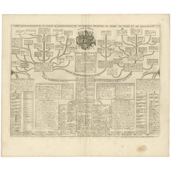
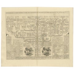
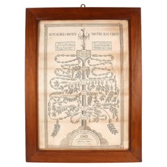
Antique Genealogy Chart of the House of Wurttemberg in Germany, 1732
$249.43
$311.7920% Off
£185.55
£231.9420% Off
€208
€26020% Off
CA$341.55
CA$426.9420% Off
A$379.76
A$474.7020% Off
CHF 198.29
CHF 247.8620% Off
MX$4,622.62
MX$5,778.2820% Off
NOK 2,530.10
NOK 3,162.6320% Off
SEK 2,370.58
SEK 2,963.2320% Off
DKK 1,583.39
DKK 1,979.2420% Off
Shipping
Retrieving quote...The 1stDibs Promise:
Authenticity Guarantee,
Money-Back Guarantee,
24-Hour Cancellation
About the Item
Antique print titled 'Genealogie de la Maison de Wirtemberg (..)'. Genealogy of the House Wurttemberg. This print orginates from 'Atlas Historique'.
The House of Württemberg is a German dynasty and former royal family from Württemberg. Due to the political upheavals during the reign of Napoleon I, and being an ally of Napoleon, Württemberg became a part of the Confederation of the Rhine, Duke Frederick II was made Elector in May 1803, he collected and received secularized and mediated dominions, which greatly enlarged his country in territorial extension. In January 1806 he was made King of Württemberg.
In 1828 King William I adopted a new house law, the rights and obligations of the ruling family have been established, including the exclusive primogeniture in the male line as well as marriage restrictions on coequal level. In 1867 the House created the Royal Dukedom of Urach for a younger cousin, Prince Wilhelm, 1st Duke of Urach, whose parents had married morganatically in 1800, whereby their sons were excluded from ruling the kingdom. In 1871 the Royal Dukedom of Teck was created for the same dynastic reason for Francis, Duke of Teck. At the end of World War I during the German Revolution all the monarchies in Germany were abolished, King William II abdicated on 30 November 1918. When former King William II died in 1921 the senior branch line of the House of Württemberg became extinct, the headship of the House passed to a distant relative, Albrecht, Duke of Württemberg.
The former royal family still owns the castles Monrepos, Altshausen and Friedrichshafen.
Artists and Engravers: Henri Abraham Chatelain (1684-1743), his father Zacharie Chatelain (d.1723) and Zacharie Junior (1690-1754), worked as a partnership publishing the Atlas Historique.
Condition: Very good, general age-related toning. Please study image carefully.
Date: 1732
Overall size: 51.6 x 44.3 cm.
Image size: 46.5 x 35.5 cm.
We also offer thousands of antique prints covering fields of interest as diverse as architecture, natural history, religion, ethnology and many more. Antique prints have long been appreciated for both their aesthetic and investment value. They were the product of engraved, etched or lithographed plates. These plates were handmade out of wood or metal, which required an incredible level of skill, patience and craftsmanship. Whether you have a house with Victorian furniture or more contemporary decor an old engraving can enhance your living space.
- Dimensions:Height: 17.45 in (44.3 cm)Width: 20.32 in (51.6 cm)Depth: 0 in (0.01 mm)
- Materials and Techniques:
- Period:
- Date of Manufacture:1732
- Condition:
- Seller Location:Langweer, NL
- Reference Number:Seller: BG-019401stDibs: LU3054325964582
About the Seller
5.0
Recognized Seller
These prestigious sellers are industry leaders and represent the highest echelon for item quality and design.
Platinum Seller
Premium sellers with a 4.7+ rating and 24-hour response times
Established in 2009
1stDibs seller since 2017
2,511 sales on 1stDibs
Typical response time: <1 hour
- ShippingRetrieving quote...Shipping from: Langweer, Netherlands
- Return Policy
Authenticity Guarantee
In the unlikely event there’s an issue with an item’s authenticity, contact us within 1 year for a full refund. DetailsMoney-Back Guarantee
If your item is not as described, is damaged in transit, or does not arrive, contact us within 7 days for a full refund. Details24-Hour Cancellation
You have a 24-hour grace period in which to reconsider your purchase, with no questions asked.Vetted Professional Sellers
Our world-class sellers must adhere to strict standards for service and quality, maintaining the integrity of our listings.Price-Match Guarantee
If you find that a seller listed the same item for a lower price elsewhere, we’ll match it.Trusted Global Delivery
Our best-in-class carrier network provides specialized shipping options worldwide, including custom delivery.More From This Seller
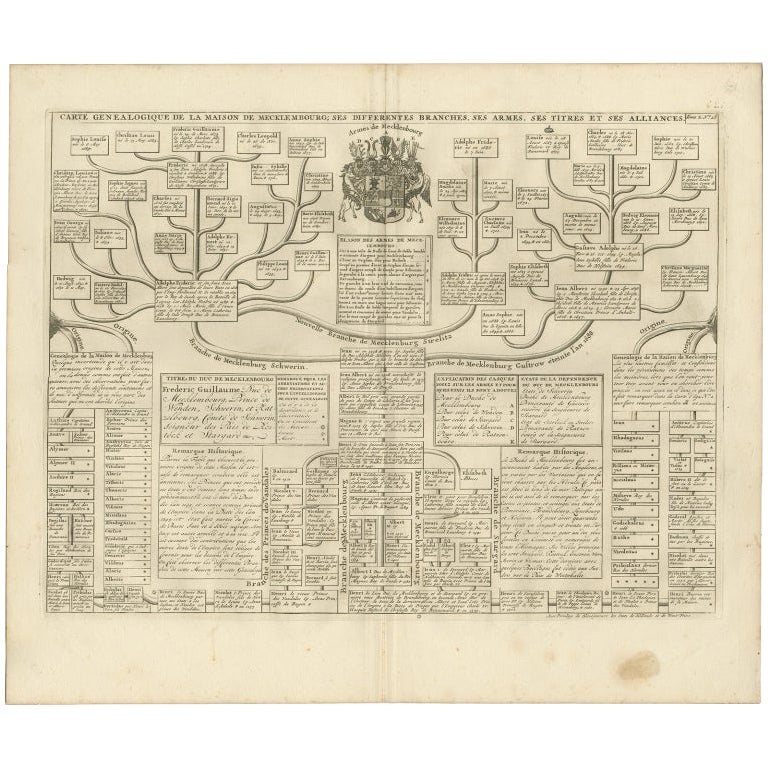
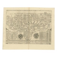
View AllAntique Genealogy Chart of the German House of Mecklenburg, 1732
Located in Langweer, NL
Antique print titled 'Carte Genealogique de la Maison de Mecklembourg (..)'. Genealogical chart of the house of Mecklenburg issuing from the lineage of Henry IV, Duke of Mecklenburg....
Category
Antique 18th Century Prints
Materials
Paper
$335 Sale Price
20% Off
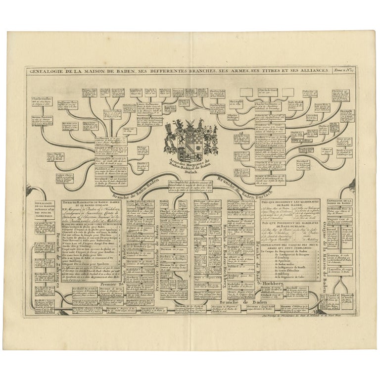
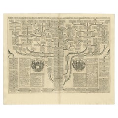
Antique Genealogy Chart of the Margraviates and Baden-Durlach, Germany, 1732
Located in Langweer, NL
Antique print titled 'Genealogie de la Maison de Baden (..)'. Chart of the genealogy of the Margraviates Baden-Baden and Baden-Durlach. This print orginates from 'Atlas Historique'. ...
Category
Antique 18th Century Prints
Materials
Paper
$268 Sale Price
20% Off
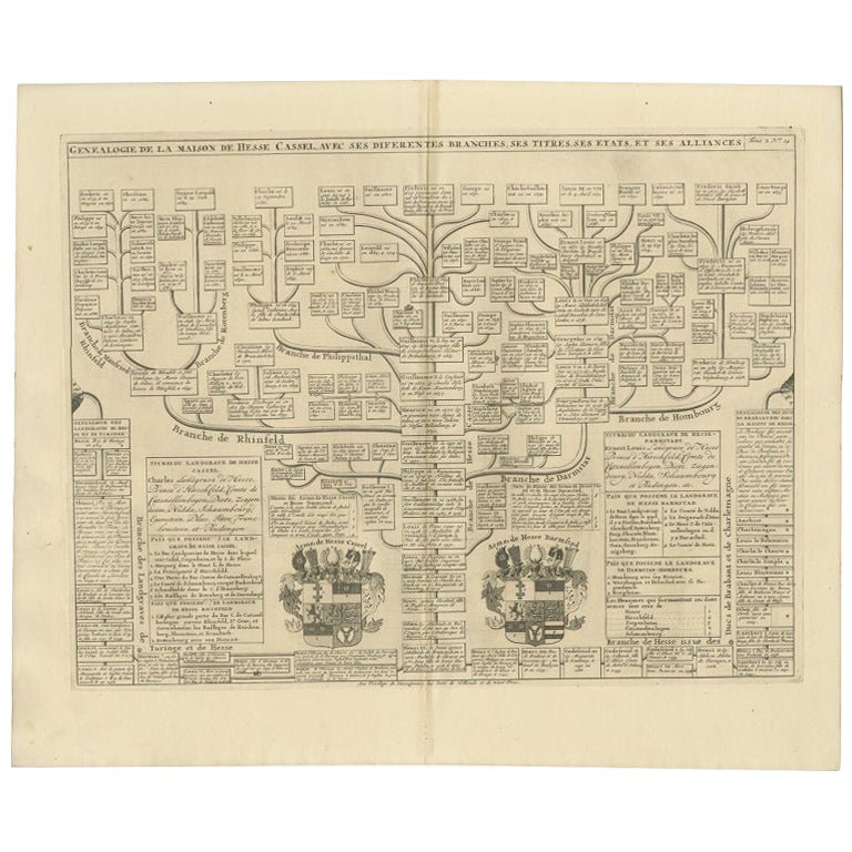
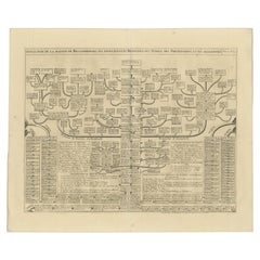
Antique Genealogy Chart of the Landgraviate Hessen-Kassel, Germany, 1732
Located in Langweer, NL
Antique print titled 'Genealogie de la Maison de Hesse Cassel'. Chart of the genealogy of the Landgraviate Hessen-Kassel / Hesse-Cassel. This includes the coats of arms of both Hesse-Cassel and Hesse-Darmstadt. This print orginates from 'Atlas Historique'.
The Landgraviate of Hesse-Kassel (German: Landgrafschaft Hessen-Kassel), spelled Hesse-Cassel during its entire existence, was a state in the Holy Roman Empire that was directly subject to the Emperor. The state was created in 1567 when the Landgraviate of Hesse was divided upon the death of Philip I, Landgrave of Hesse. His eldest son William IV inherited the northern half of the Landgraviate and the capital of Kassel. The other sons received the Landgraviate of Hesse-Marburg, the Landgraviate of Hesse-Rheinfels and the Landgraviate of Hesse-Darmstadt.
During the Napoleonic reorganisation of the Empire in 1803, the Landgrave of Hesse-Kassel was elevated to an Electorate and Landgrave William IX became an Imperial Elector. Many members of the Hesse-Kassel House served in the Danish military gaining high ranks and power in the Oldenburg realm due to the fact that many Landgraves were married to Danish princesses...
Category
Antique 18th Century Prints
Materials
Paper
$249 Sale Price
20% Off
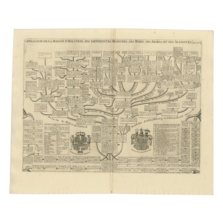
Antique Genealogy Chart of the House of Holstein, 1732
Located in Langweer, NL
Antique print titled 'Carte Genealogique d'Holstein (..)'. Genealogical chart of the house Holstein. Shows both the ducal and the royal arms of the House (the ducal arms with keyed l...
Category
Antique 18th Century Prints
Materials
Paper
$230 Sale Price
20% Off
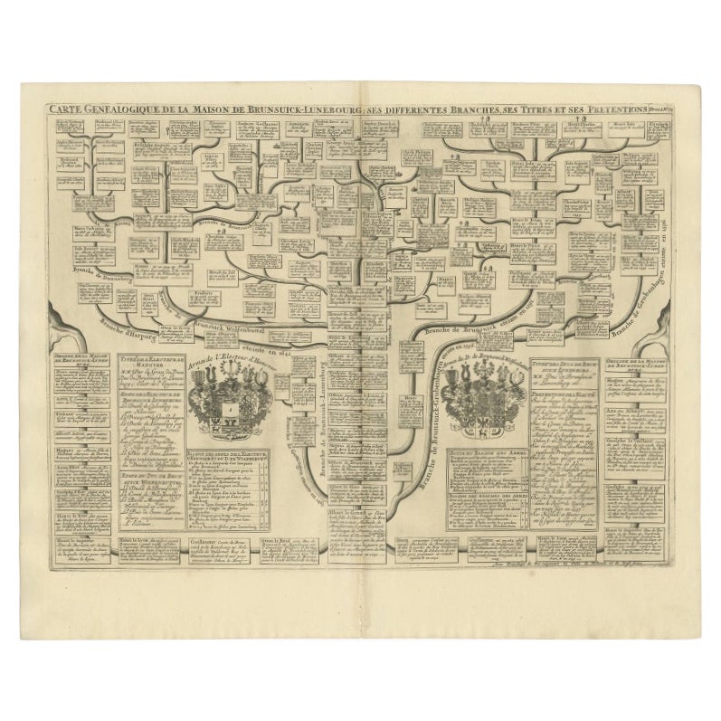
Antique Genealogy Chart of the Duchy of Brunswick-Luneburg, Germany, 1732
Located in Langweer, NL
Antique print titled 'Carte Genealogique de la Maison de Brunsuick-Lunebourg'. Genealogy of the Duchy of Brunswick-Luneburg. With coats of arms of the Elector of Hannover and the Duc...
Category
Antique 18th Century Prints
Materials
Paper
$230 Sale Price
20% Off
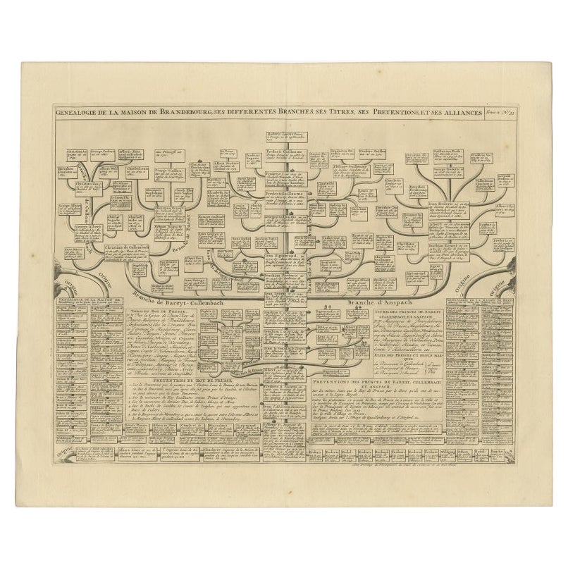
Old Genealogy Chart of the Rulers of Margraviate Brandenburg in Germany, 1732
Located in Langweer, NL
Antique print titled 'Genealogie de la Maison de Brandebourg (..)'. Genealogy of the rulers of the Margraviate Brandenburg. This print orginates from 'Atlas Historique'.
The Margraviate of Brandenburg (German: Markgrafschaft Brandenburg) was a major principality of the Holy Roman Empire from 1157 to 1806 that played a pivotal role in the history of Germany and Central Europe. Brandenburg developed out of the Northern March founded in the territory of the Slavic Wends. It derived one of its names from this inheritance, the March of Brandenburg (Mark Brandenburg). Its ruling margraves were established as prestigious prince-electors in the Golden Bull...
Category
Antique 18th Century Prints
Materials
Paper
$230 Sale Price
20% Off
You May Also Like
The Genealogy of Jesus, print on Italian paper from 1820.
Located in Milan, IT
A paper print depicting the genealogy of Jesus, his family tree, with the charm of a time machine reconstructs the genealogy of Christ's ancestors, as per the Gospel according to Mat...
Category
Antique Early 19th Century Italian Religious Items
Materials
Glass, Fruitwood, Paper
Original Antique Map of Switzerland, Engraved By Barlow, Dated 1807
Located in St Annes, Lancashire
Great map of Switzerland
Copper-plate engraving by Barlow
Published by Brightly & Kinnersly, Bungay, Suffolk.
Dated 1807
Unframed.
Category
Antique Early 1800s English Maps
Materials
Paper

John Ogilby Oxford to Salisbury Road Map #83 Circa 1675
By John Ogilby
Located in Atlanta, GA
John Ogilby (Scottish, 1600-1676). - Circa 1675
This map is part of his Britannica publication and is #83.
"The road map was first popularised by John Ogilby (1600-1676), Scotsm...
Category
Antique 17th Century Scottish Regency Decorative Art
Materials
Burl, Paper
$716 Sale Price
20% Off
1714 Henri Chatelain "Nouvelle Carte Des Etatas Du Grand.Duc De Mos Moscovie Eur
Located in Norton, MA
A 1714 Henri Chatelain map, entitled
"Nouvelle Carte Des Etatas Du Grand Duc De Moscovie En Europe,"
Ricb001
Henri Abraham Chatelain (1684-1743) was a Huguenot pastor of Parisi...
Category
Antique Early 18th Century Dutch Maps
Materials
Paper

John Ogilby Oxford to Salisbury Road Map #82 Circa 1675
By John Ogilby
Located in Atlanta, GA
John Ogilby (Scottish, 1600-1676). - Circa 1675
This map is part of his Britannica publication and is #82.
"The road map was first popularised by John Ogilby (1600-1676), Scotsm...
Category
Antique 17th Century Scottish French Provincial Decorative Art
Materials
Burl
$716 Sale Price
20% Off
Mid-18th Century Hand Drawn English Farm Map on Vellum, circa 1740s
Located in San Francisco, CA
Mid-18th century hand drawn English farm map on Vellum circa 1740s
Henry Maxted & Isaac Terry, Surveyors.
A Map of a Farm in the Parish of Blean in the County of KENT: Belonging to Mrs Elizabeth Hodgson circa 1743.
A beautiful hand drawn map...
Category
Antique Mid-18th Century English Maps
Materials
Lambskin

More Ways To Browse
German Wurttemberg
Antique Figureheads
Antique Fireplace Mantel Clocks
Antique French Roll Top Desk
Antique Gentlemans Chest
Antique Greek Pots
Antique Japanese Tea Pot
Antique Mahogany Chest Of Drawers With Mirror
Antique Mandala
Antique Pipe Stand
Antique Room Divider Antiques
Antique Settle Table
Antique Temple Jar
Antique Vanity Jars
Antique Wood Wagon
Antique Yard Long
Art Deco Coffee Cup
Bali Style