Items Similar to Antique Genealogy Chart of Palatinate & Bavarian Houses with Coats of Arms, 1732
Want more images or videos?
Request additional images or videos from the seller
1 of 6
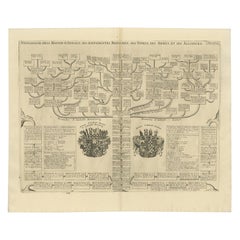
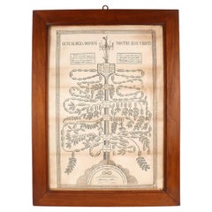
Antique Genealogy Chart of Palatinate & Bavarian Houses with Coats of Arms, 1732
$230.24
$287.8020% Off
£171.28
£214.1020% Off
€192
€24020% Off
CA$315.28
CA$394.1020% Off
A$350.55
A$438.1920% Off
CHF 183.04
CHF 228.8020% Off
MX$4,267.04
MX$5,333.7920% Off
NOK 2,335.48
NOK 2,919.3520% Off
SEK 2,188.23
SEK 2,735.2920% Off
DKK 1,461.59
DKK 1,826.9920% Off
Shipping
Retrieving quote...The 1stDibs Promise:
Authenticity Guarantee,
Money-Back Guarantee,
24-Hour Cancellation
About the Item
Antique print titled 'Genealogie de la Maison Palatine (..)'. Chart of the genealogy of the Palatinate (Die Pfalz) and Bavarian (Baiern) Houses. Shows the coats of arms of both Electorates, with a long genealogical table. This print orginates from 'Atlas Historique'.
Artists and Engravers: Henri Abraham Chatelain (1684-1743), his father Zacharie Chatelain (d.1723) and Zacharie Junior (1690-1754), worked as a partnership publishing the Atlas Historique.
Condition: Very good, general age-related toning. Please study image carefully.
Date: 1732
Overall size: 55.3 x 44.9 cm.
Image size: 52.4 x 35.5 cm.
We also offer thousands of antique prints covering fields of interest as diverse as architecture, natural history, religion, ethnology and many more. Antique prints have long been appreciated for both their aesthetic and investment value. They were the product of engraved, etched or lithographed plates. These plates were handmade out of wood or metal, which required an incredible level of skill, patience and craftsmanship. Whether you have a house with Victorian furniture or more contemporary decor an old engraving can enhance your living space.
- Dimensions:Height: 17.68 in (44.9 cm)Width: 21.78 in (55.3 cm)Depth: 0 in (0.01 mm)
- Materials and Techniques:
- Period:
- Date of Manufacture:1732
- Condition:
- Seller Location:Langweer, NL
- Reference Number:Seller: BG-019241stDibs: LU3054325965132
About the Seller
5.0
Recognized Seller
These prestigious sellers are industry leaders and represent the highest echelon for item quality and design.
Platinum Seller
Premium sellers with a 4.7+ rating and 24-hour response times
Established in 2009
1stDibs seller since 2017
2,511 sales on 1stDibs
Typical response time: <1 hour
- ShippingRetrieving quote...Shipping from: Langweer, Netherlands
- Return Policy
Authenticity Guarantee
In the unlikely event there’s an issue with an item’s authenticity, contact us within 1 year for a full refund. DetailsMoney-Back Guarantee
If your item is not as described, is damaged in transit, or does not arrive, contact us within 7 days for a full refund. Details24-Hour Cancellation
You have a 24-hour grace period in which to reconsider your purchase, with no questions asked.Vetted Professional Sellers
Our world-class sellers must adhere to strict standards for service and quality, maintaining the integrity of our listings.Price-Match Guarantee
If you find that a seller listed the same item for a lower price elsewhere, we’ll match it.Trusted Global Delivery
Our best-in-class carrier network provides specialized shipping options worldwide, including custom delivery.More From This Seller
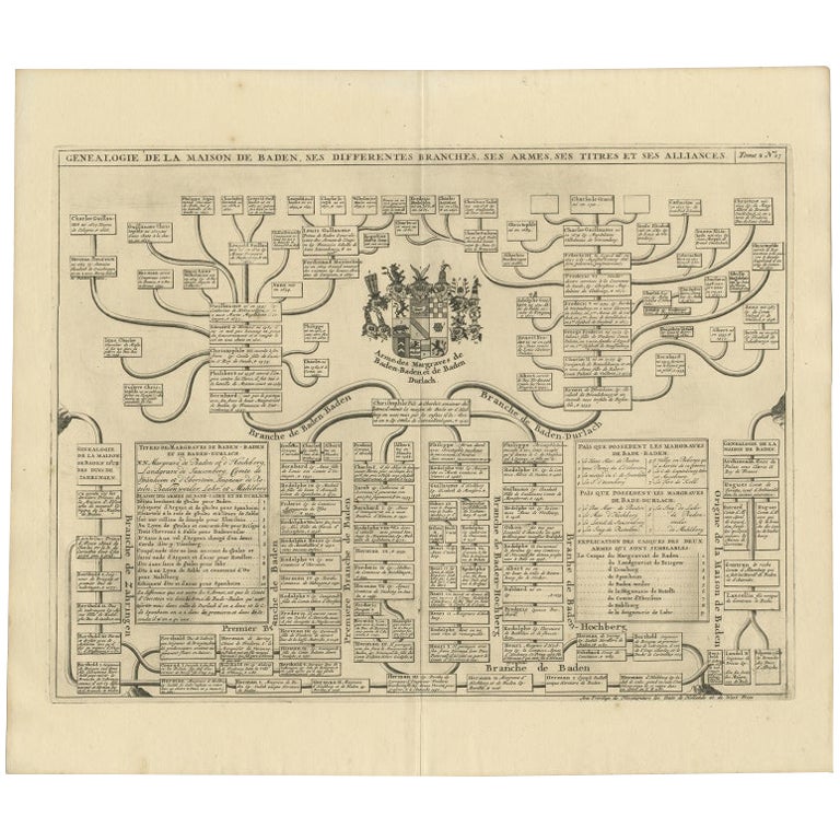
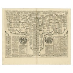
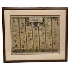
View AllAntique Genealogy Chart of the Margraviates and Baden-Durlach, Germany, 1732
Located in Langweer, NL
Antique print titled 'Genealogie de la Maison de Baden (..)'. Chart of the genealogy of the Margraviates Baden-Baden and Baden-Durlach. This print orginates from 'Atlas Historique'. ...
Category
Antique 18th Century Prints
Materials
Paper
$268 Sale Price
20% Off
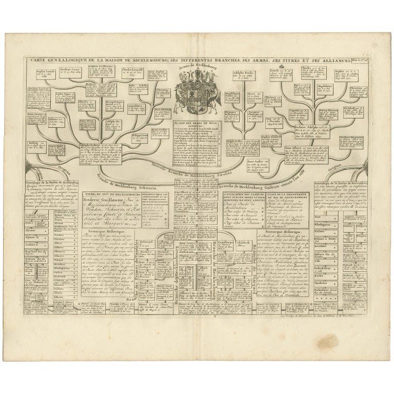
Antique Genealogy Chart of the German House of Mecklenburg, 1732
Located in Langweer, NL
Antique print titled 'Carte Genealogique de la Maison de Mecklembourg (..)'. Genealogical chart of the house of Mecklenburg issuing from the lineage of Henry IV, Duke of Mecklenburg....
Category
Antique 18th Century Prints
Materials
Paper
$335 Sale Price
20% Off
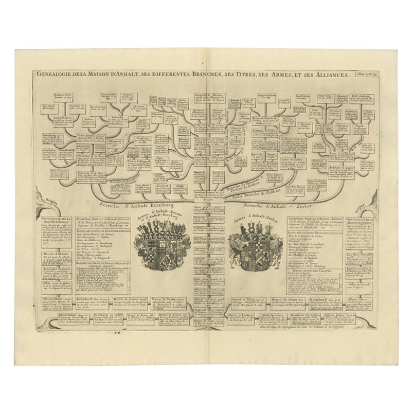
Antique Genealogy Chart of the Duchy of Anhalt Dessau, Bernburg and Zerbst, 1732
Located in Langweer, NL
Antique print titled 'Genealogie de la Maison d'Anhalt'. Chart of the genealogy of the house of the Duchy of Anhalt. Two coats of arms, on the left Anhalt-...
Category
Antique 18th Century Prints
Materials
Paper
$172 Sale Price
20% Off
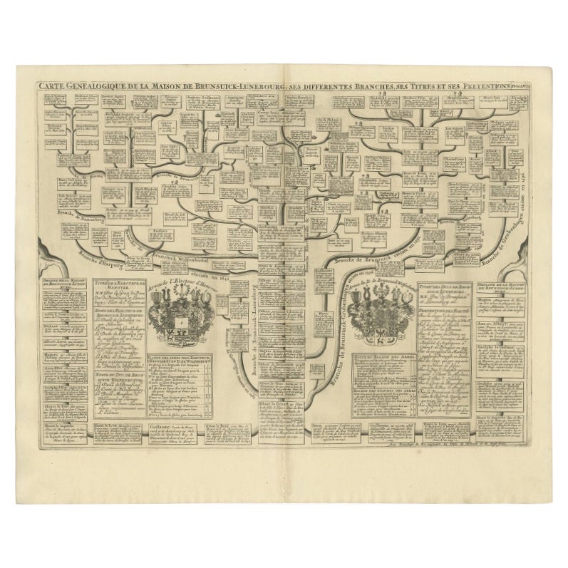
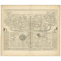
Antique Genealogy Chart of the Duchy of Brunswick-Luneburg, Germany, 1732
Located in Langweer, NL
Antique print titled 'Carte Genealogique de la Maison de Brunsuick-Lunebourg'. Genealogy of the Duchy of Brunswick-Luneburg. With coats of arms of the Elector of Hannover and the Duc...
Category
Antique 18th Century Prints
Materials
Paper
$230 Sale Price
20% Off
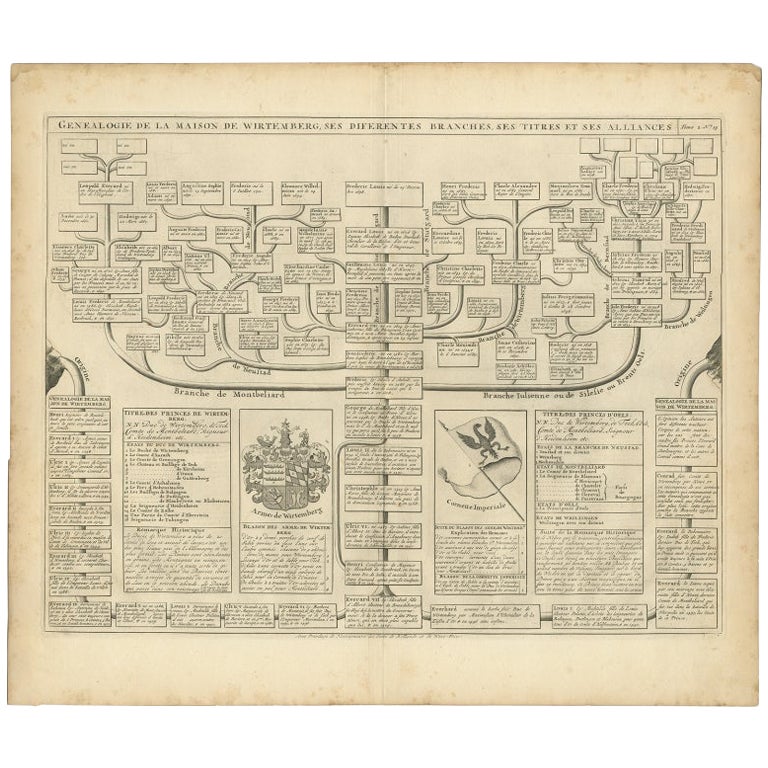
Antique Genealogy Chart of the House of Wurttemberg in Germany, 1732
Located in Langweer, NL
Antique print titled 'Genealogie de la Maison de Wirtemberg (..)'. Genealogy of the House Wurttemberg. This print orginates from 'Atlas Historique'.
The House of Württemberg is a...
Category
Antique 18th Century Prints
Materials
Paper
$249 Sale Price
20% Off
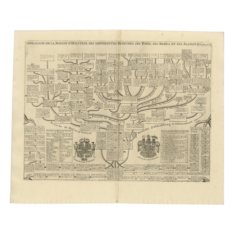
Antique Genealogy Chart of the House of Holstein, 1732
Located in Langweer, NL
Antique print titled 'Carte Genealogique d'Holstein (..)'. Genealogical chart of the house Holstein. Shows both the ducal and the royal arms of the House (the ducal arms with keyed l...
Category
Antique 18th Century Prints
Materials
Paper
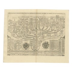
$230 Sale Price
20% Off
You May Also Like
17th Century Hand Colored Map of the Liege Region in Belgium by Visscher
By Nicolaes Visscher II
Located in Alamo, CA
An original 17th century map entitled "Leodiensis Episcopatus in omnes Subjacentes Provincias distincté divisusVisscher, Leodiensis Episcopatus" by Nicolaes Visscher II, published in Amsterdam in 1688. The map is centered on Liege, Belgium, includes the area between Antwerp, Turnhout, Roermond, Cologne, Trier and Dinant.
This attractive map is presented in a cream-colored mat measuring 30" wide x 27.5" high. There is a central fold, as issued. There is minimal spotting in the upper margin and a tiny spot in the right lower margin, which are under the mat. The map is otherwise in excellent condition.
The Visscher family were one of the great cartographic families of the 17th century. Begun by Claes Jansz Visscher...
Category
Antique Late 17th Century Dutch Maps
Materials
Paper

18th Century Hand-Colored Homann Map of Germany, Including Frankfurt and Berlin
By Johann Baptist Homann
Located in Alamo, CA
An 18th century hand-colored map entitled "Tabula Marchionatus Brandenburgici et Ducatus Pomeraniae quae sunt Pars Septentrionalis Circuli Saxoniae Superioris" by Johann Baptist Homa...
Category
Antique Early 18th Century German Maps
Materials
Paper

Original Antique Map of Switzerland, Engraved By Barlow, Dated 1807
Located in St Annes, Lancashire
Great map of Switzerland
Copper-plate engraving by Barlow
Published by Brightly & Kinnersly, Bungay, Suffolk.
Dated 1807
Unframed.
Category
Antique Early 1800s English Maps
Materials
Paper

The Genealogy of Jesus, print on Italian paper from 1820.
Located in Milan, IT
A paper print depicting the genealogy of Jesus, his family tree, with the charm of a time machine reconstructs the genealogy of Christ's ancestors, as per the Gospel according to Mat...
Category
Antique Early 19th Century Italian Religious Items
Materials
Glass, Fruitwood, Paper
John Ogilby Oxford to Salisbury Road Map #83 Circa 1675
By John Ogilby
Located in Atlanta, GA
John Ogilby (Scottish, 1600-1676). - Circa 1675
This map is part of his Britannica publication and is #83.
"The road map was first popularised by John Ogilby (1600-1676), Scotsm...
Category
Antique 17th Century Scottish Regency Decorative Art
Materials
Burl, Paper
$716 Sale Price
20% Off
1627 Hondius Map "La Principaute d'Orange et Comtat de Ve", Ric.0003
Located in Norton, MA
1627 Hondius map entitled
"La Principaute d'Orange et Comtat de Venaissin,"
Original Hand-Colored
Description: From Johannes Janssonius's Atlantis Maioris Appendix of 1630.
...
Category
Antique 17th Century Unknown Maps
Materials
Paper

More Ways To Browse
Antique Chart Table
Antique Figureheads
Antique Fireplace Mantel Clocks
Antique French Roll Top Desk
Antique Gentlemans Chest
Antique Greek Pots
Antique Japanese Tea Pot
Antique Mahogany Chest Of Drawers With Mirror
Antique Mandala
Antique Pipe Stand
Antique Room Divider Antiques
Antique Settle Table
Antique Temple Jar
Antique Vanity Jars
Antique Wood Wagon
Antique Yard Long
Art Deco Coffee Cup
Bali Style