Items Similar to 1627 Hondius Map "La Principaute d'Orange et Comtat de Ve", Ric.0003

Want more images or videos?
Request additional images or videos from the seller
1 of 14
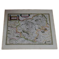
1627 Hondius Map "La Principaute d'Orange et Comtat de Ve", Ric.0003
About the Item
1627 Hondius map entitled
"La Principaute d'Orange et Comtat de Venaissin,"
Original Hand-Colored
Description: From Johannes Janssonius's Atlantis Maioris Appendix of 1630.
Artists and Engravers:
La Principaute d'Orange...
La Principaute d'Orange et Comtat de Venaissin (Vaucluse, France) was originally published in 1630 and was republished in atlases until 1637. However, the title cartouche declares that the map was engraved in 1627. The additional cartouche in the upper right corner reveals that it was published by both Hondius brothers, Jodocus and Henricus, and the inscription in the bottom right corner details that the copper plate was engraved by Evert Symonz. Hamersvelt. Hamersvelt worked for both the Hondius brothers at different points in his career.
Dimension: Paper: 22.3" W x 19.1" H (56.7 cm W x 48.5 cm H) ; Sight: 19.7" x 15" H (50 cm W x 38 cm H)
Condition: Good Condition with aged toning, please see photos.
- Dimensions:Height: 19.1 in (48.5 cm)Width: 22.33 in (56.7 cm)Depth: 0.4 in (1 cm)
- Sold As:Set of 2
- Materials and Techniques:
- Place of Origin:
- Period:
- Date of Manufacture:1633
- Condition:
- Seller Location:Norton, MA
- Reference Number:1stDibs: LU5848230265622
About the Seller
5.0
Platinum Seller
These expertly vetted sellers are 1stDibs' most experienced sellers and are rated highest by our customers.
Established in 2000
1stDibs seller since 2021
85 sales on 1stDibs
Typical response time: <1 hour
- ShippingRetrieving quote...Ships From: Norton, MA
- Return PolicyA return for this item may be initiated within 3 days of delivery.
More From This SellerView All
- 1627 Hendrik Hondius Map Entitled "Vltoniae Orientalis Pars, " Ric.a009Located in Norton, MA1627 Hendrik Hondius map entitled "Vltoniae orientalis pars," Ric.a009 Title: Vltoniae orientalis : pars Title (alt.) : Ultoniae orientalis pars Creator: Mercator, Gerh...Category
Antique 17th Century Dutch Maps
MaterialsPaper
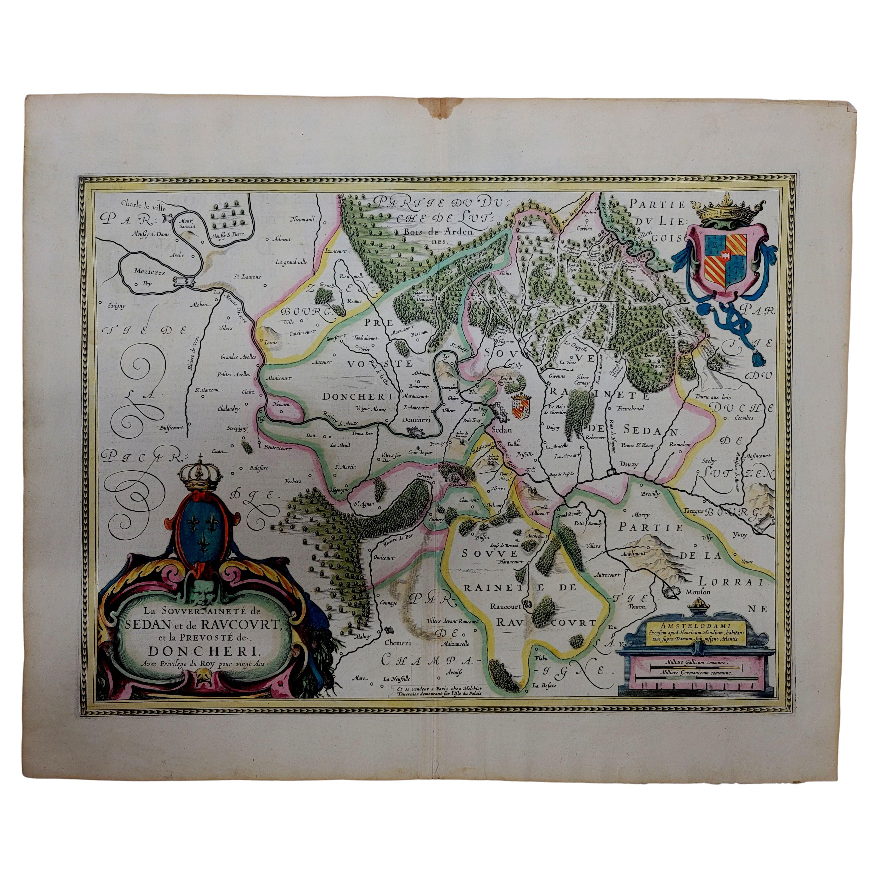
- 1633 Map "La Souverainete De Sedan Et De Raucourt, Et La Prevoste Ric0011Located in Norton, MA1653 map entitled "La Souverainete de Sedan et de Raucourt, et la Prevoste de Doncheri," Ric0011 Description: Lovely map centered on Sedan and Doncheri and the Meuze River fr...Category
Antique 17th Century Dutch Maps
MaterialsPaper
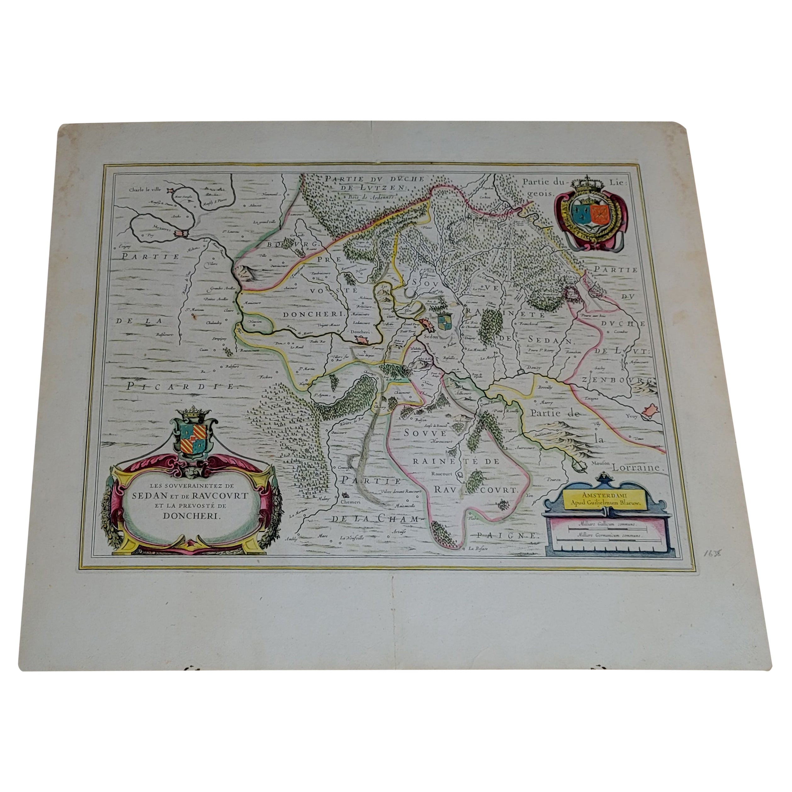
- 1656 "La Souverainete de Sedan et de Raucourt, et la Prevoste de Doncheri Ric004Located in Norton, MA1656 map entitled "La Souverainete de Sedan et de Raucourt, et la Prevoste de Doncheri," Hand Colored Ric0004. Description: Lovely map centered on Sedan and Doncheri an...Category
Antique 17th Century Dutch Maps
MaterialsPaper
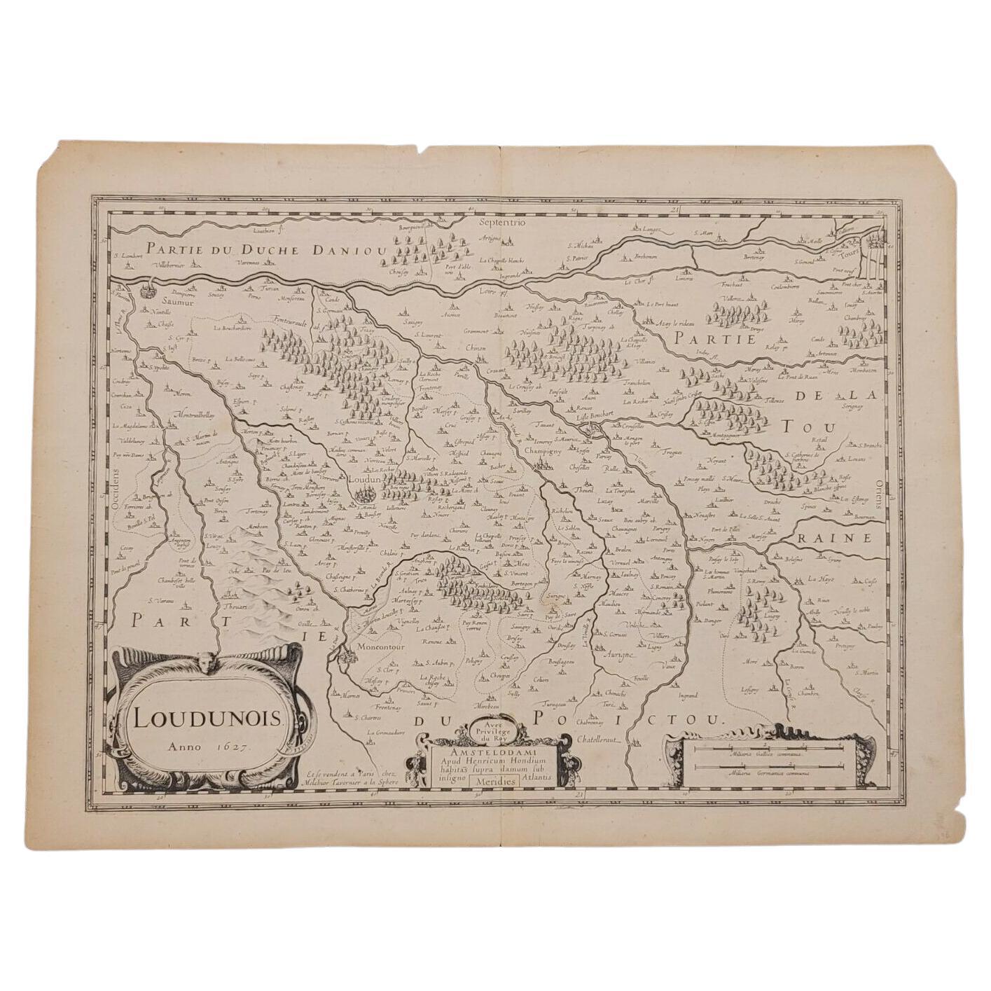
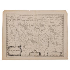
- 1627 Map Entitled "Loudunois, " Signed on the Back, Ric.a013Located in Norton, MA1627 map entitled "Loudunois," Signed on the Back Ric.a013 cartography close up double-page hand-colored elevated view no person print hand-tinted hilly close-up early 17th-...Category
Antique 17th Century Dutch Maps
MaterialsPaper
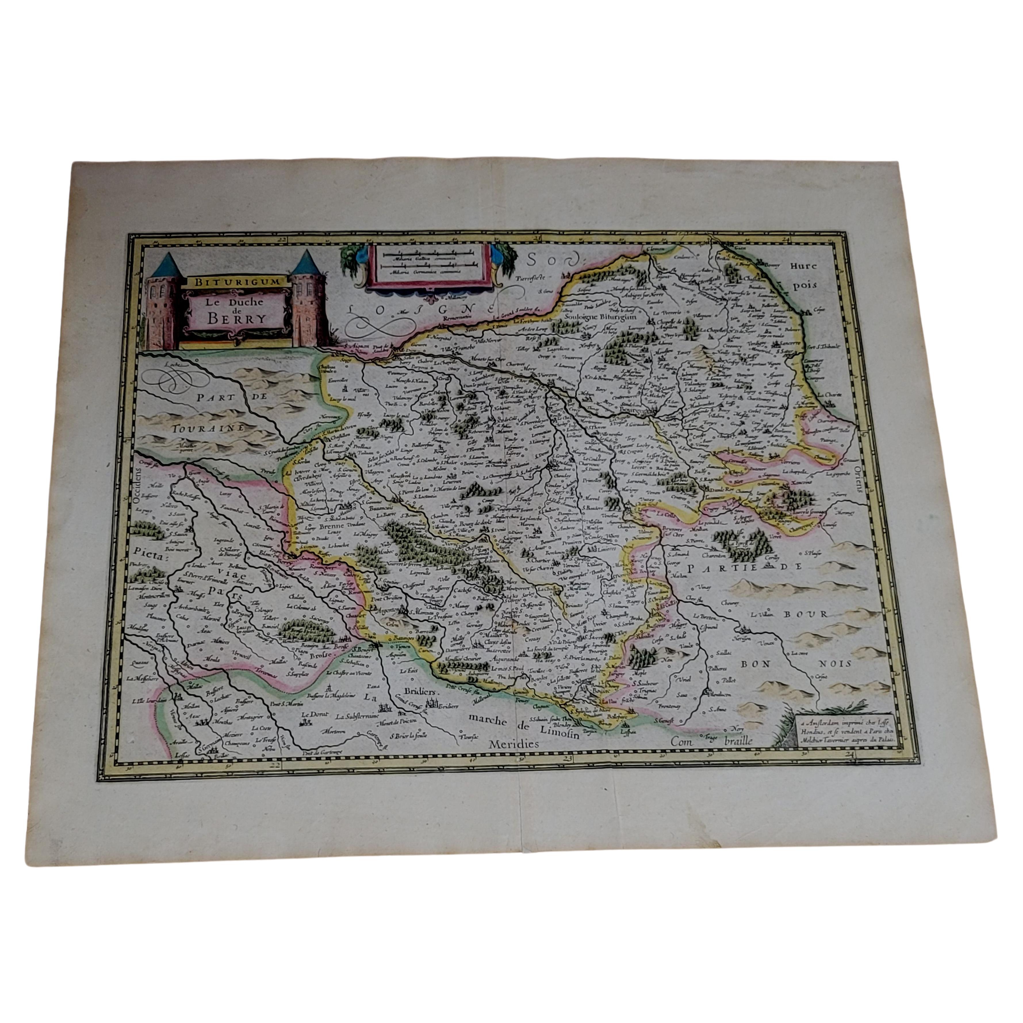
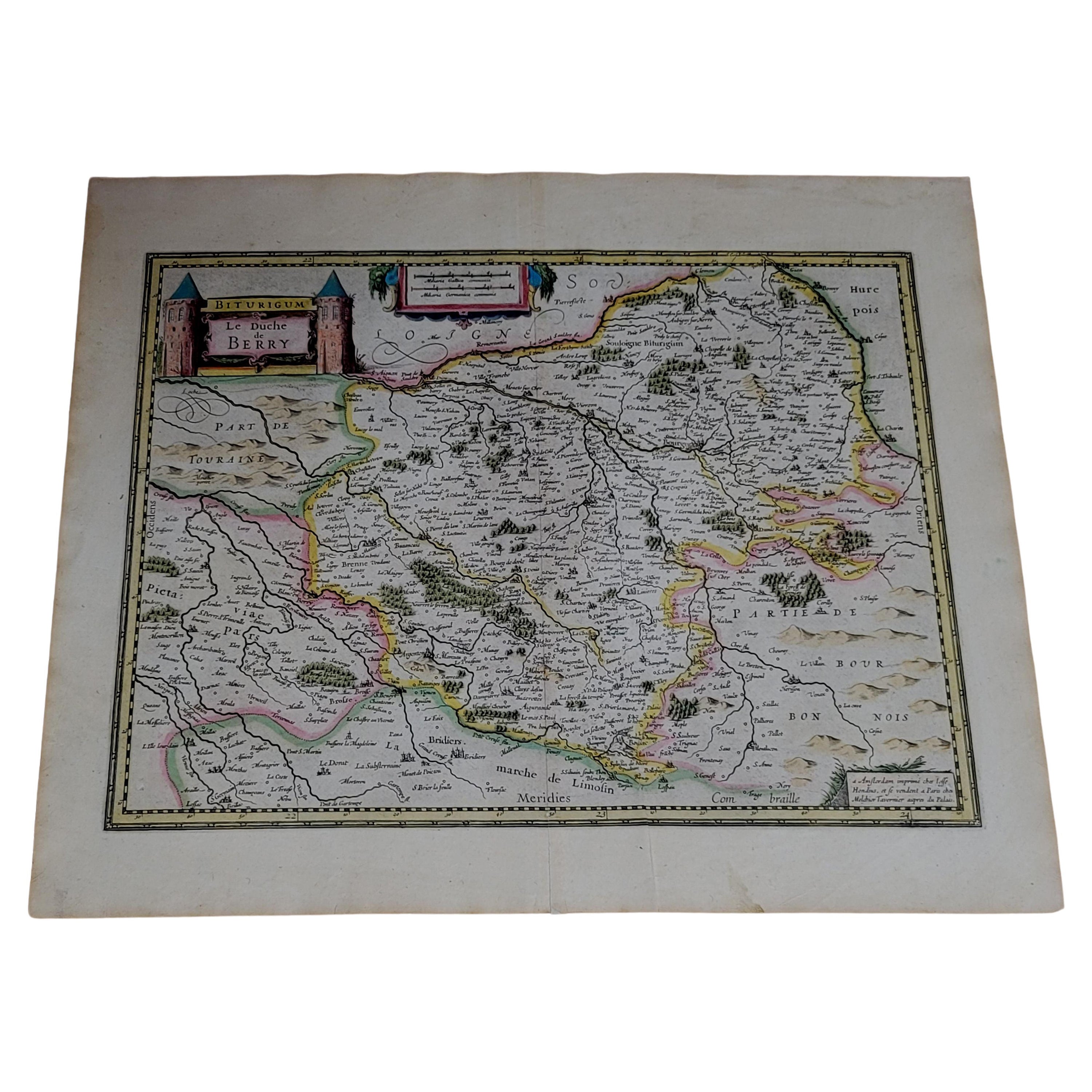
- 1633 Map, Entitled "La Douche De Berry, " Ric.0005Located in Norton, MA1633 map, entitled "La douche de Berry," Hand Colored Ric.0005 Description: 1633 map, entitled "La douche de Berry," Dimension: Paper: 23.3" W x 20.3" H (59 cm W x 51.7 c...Category
Antique 17th Century Unknown Maps
MaterialsPaper
- 1633 map, entitled "La douche de Berry, " Original Hand Colored Ric.0005Located in Norton, MA1633 map, entitled "La douche de Berry," Hand Colored Ric.0005 Description: 1633 map, entitled "La douche de Berry," Dimension: Paper: 23.3" W x 20.3" H (59 cm W x 51.7 cm H) ; ...Category
Antique 17th Century Dutch Maps
MaterialsPaper


You May Also Like
- Antique Map of the Region of Hauts-de-France by Hondius, circa 1630Located in Langweer, NLAntique map titled 'Description du Gouvernement de la Cappelle'. Old map of the region of Hauts-de-France including the cities of Vervins, Marle, Cappelle and others. This map origin...Category
Antique Mid-17th Century Maps
MaterialsPaper
- Antique Map of the Region of Île-de-France by Hondius, circa 1630Located in Langweer, NLAntique map titled Gouvernement de l'Isle de France'. Old map of the region of Île-de-France, France. It is located in the north-central part of the country and often called the régi...Category
Antique Mid-17th Century Maps
MaterialsPaper
- Map of the Holy Land "Carte de la Syrie et de l'Egypte" by Pierre M. LapieBy Pierre M. LapieLocated in Alamo, CAAn early 19th century map of ancient Syria and Egypt entitled "Carte de la Syrie et de l'Egypte anciennes/dressée par M. Lapie, Colonel d'Etat Major, et...Category
Antique Early 19th Century French Maps
MaterialsPaper
- Framed Mercator Hondius Hispania Nova Atlas Minor MapLocated in Stamford, CTFramed colored example of this decorative and important minature map. Newly framed in brown wood frame with gold trim. Mercator Hondius “Atlas Minor” pu...Category
Antique 17th Century Dutch Spanish Colonial Maps
MaterialsGlass, Wood, Paper
- Antique Map of Hertfordshire in England by Speed, 1627Located in Langweer, NLAntique map titled 'Hartfordshire described the sittuations of Hartford (..)'. Map of Hertfordshire, England. Includes inset maps of Hertford and the Roman settlement of Verolani...Category
Antique 17th Century Maps
MaterialsPaper
- Antique Map of Africa Made after Hondius, circa 1655Located in Langweer, NLAntique map titled 'Africa Nova Tabula Auct Jud. Hondio'. Beautiful and rare paneled map of Africa, Based Upon Hondius' map. The first derivative of the map was issued separately by ...Category
Antique Mid-17th Century Maps
MaterialsPaper


Recently Viewed
View AllMore Ways To Browse
Orange Furniture La
17th Century Copper Plate
Henricus Hondius
Atlantis Antique
Nautical Map
Nautical Maps
Antique Style Atlas
Pacific Map
Antique Ship Decor
Coastal Maps
Antique Maps Mexico
Antique Sea Charts
Antique Roman Map
Antique Sea Chart
Mexico Antique Map
Amsterdam Coat Of Arms
Antique Texas Collectables
Large Map Of The Netherlands