Items Similar to Antique Map of Kerguelens Island Coast in the Indian Ocean by Cook, 1785

Want more images or videos?
Request additional images or videos from the seller
1 of 6
Antique Map of Kerguelens Island Coast in the Indian Ocean by Cook, 1785
$527.18
£392.45
€440
CA$722.11
A$803.14
CHF 419.38
MX$9,773.40
NOK 5,356.08
SEK 5,023.05
DKK 3,349.57
Shipping
Retrieving quote...The 1stDibs Promise:
Authenticity Guarantee,
Money-Back Guarantee,
24-Hour Cancellation
About the Item
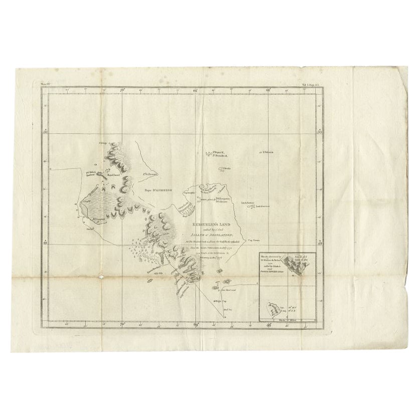
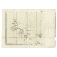
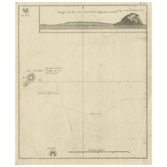
Antique print titled 'Kerguelen's Land (..)'. Antique map of Kerguelens island coast, known today as the Desolation islands. Originates from 'Voyage to the Pacific Ocean, undertaken by the Command of His Majesty, for making discoveries in the Northern Hemisphere' published in London.
Artists and Engravers: James Cook (Author, 1728-1779) was a British captain, explorer and cartographer.
Condition: Good, some wear and age-related toning. Please study image carefully.
Date: 1785
Overall size: 48 x 31.5 cm.
Image size: 29 x 24.5 cm.
Antique prints have long been appreciated for both their aesthetic and investment value. They were the product of engraved, etched or lithographed plates. These plates were handmade out of wood or metal, which required an incredible level of skill, patience and craftsmanship. Whether you have a house with Victorian furniture or more contemporary decor an old engraving can enhance your living space.
- Creator:James Cook (Author)
- Dimensions:Height: 12.6 in (32 cm)Width: 18.9 in (48 cm)Depth: 0 in (0.01 mm)
- Materials and Techniques:
- Period:
- Date of Manufacture:1785
- Condition:Condition: Good, some wear and age-related toning. Please study image carefully.
- Seller Location:Langweer, NL
- Reference Number:Seller: BGJC-2091stDibs: LU3054329869842
About the Seller
5.0
Recognized Seller
These prestigious sellers are industry leaders and represent the highest echelon for item quality and design.
Platinum Seller
Premium sellers with a 4.7+ rating and 24-hour response times
Established in 2009
1stDibs seller since 2017
2,510 sales on 1stDibs
Typical response time: <1 hour
- ShippingRetrieving quote...Shipping from: Langweer, Netherlands
- Return Policy
Authenticity Guarantee
In the unlikely event there’s an issue with an item’s authenticity, contact us within 1 year for a full refund. DetailsMoney-Back Guarantee
If your item is not as described, is damaged in transit, or does not arrive, contact us within 7 days for a full refund. Details24-Hour Cancellation
You have a 24-hour grace period in which to reconsider your purchase, with no questions asked.Vetted Professional Sellers
Our world-class sellers must adhere to strict standards for service and quality, maintaining the integrity of our listings.Price-Match Guarantee
If you find that a seller listed the same item for a lower price elsewhere, we’ll match it.Trusted Global Delivery
Our best-in-class carrier network provides specialized shipping options worldwide, including custom delivery.More From This Seller
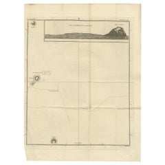
View AllAntique Map of Kerguelens Island Coast by Cook, 1784
By James Cook
Located in Langweer, NL
Antique print titled 'Kerguelen's Land (..)'. Antique map of Kerguelens island coast, known today as the Desolation islands. Originates from 'A Voyage to the Pacific Ocean: Undertaken, by the Command of His Majesty, for Making Discoveries in the Northern Hemisphere (..)' published in Dublin.
Artists and Engravers: James Cook...
Category
Antique 18th Century Prints
Materials
Paper
$323 Sale Price
25% Off
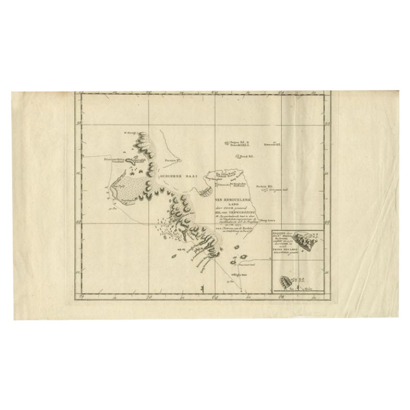
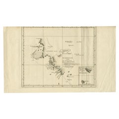
Antique Map of the Coast of Kerguelens Island by Cook, 1803
Located in Langweer, NL
Antique map Desolation Islands titled 'Van Kerguelens Land door Cook genaamd (..)'. Antique map of Kerguelens island coast, known today as the Desolation islands. Originates from 'Re...
Category
Antique 19th Century Maps
Materials
Paper
$294 Sale Price
20% Off
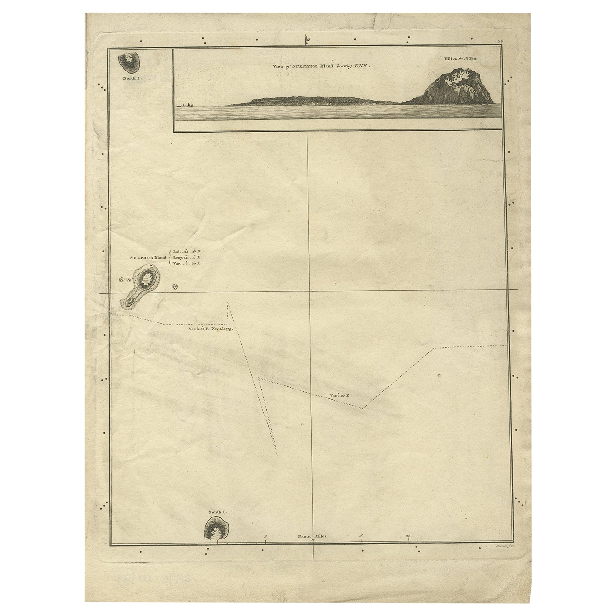
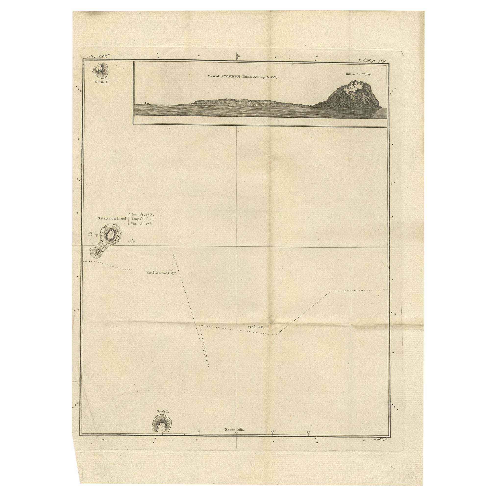
Antique Map of Suffren Island by Cook, 1784
Located in Langweer, NL
Antique map titled 'View of Sulphur Island (..)'. Antique map and view of Suffren Island. Originates from an edition of Cook's Voyages.
Artists and Engravers: Published by Nicol, ...
Category
Antique 18th Century Maps
Materials
Paper
$143 Sale Price
20% Off
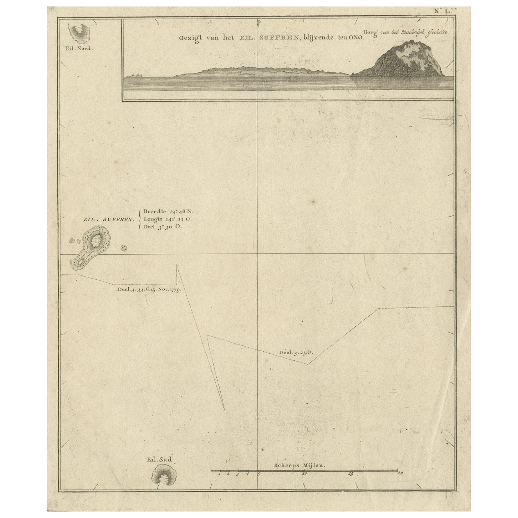
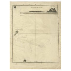
Antique Map of Suffren Island by Cook, 1803
Located in Langweer, NL
Antique map Australia titled 'Gezigt van het Eil. Suffren'. Antique map of Suffren Island. Originates from 'Reizen Rondom de Waereld door James C...
Category
Antique 19th Century Maps
Materials
Paper
$172 Sale Price
20% Off
Antique Map of the Friendly Islands by Cook, 1803
Located in Langweer, NL
Antique map Friendly Islands titled 'Kaart van de Vrienden-Eilanden'. Antique map of the Friendly Islands depicting Rotterdam or Anamocka, Middelburg or Eaoowe and Amsterdam or Tonga...
Category
Antique 19th Century Maps
Materials
Paper

$206 Sale Price
20% Off
Antique Map of Suffren Island by Cook, c.1781
Located in Langweer, NL
Antique map titled 'View of Sulphur Island (..)'. Antique map and view of Suffren Island. Originates from an edition of Cook's Voyages.
Artists and Engravers: Engraved by Duff.
...
Category
Antique 18th Century Maps
Materials
Paper
$143 Sale Price
20% Off
You May Also Like
West Coast of Africa, Guinea & Sierra Leone: An 18th Century Map by Bellin
By Jacques-Nicolas Bellin
Located in Alamo, CA
Jacques Bellin's copper-plate map entitled "Partie de la Coste de Guinee Dupuis la Riviere de Sierra Leona Jusquau Cap das Palmas", depicting the coast of Guinea and Sierra Leone in ...
Category
Antique Mid-18th Century French Maps
Materials
Paper

Very Large Hand-Drawn View of St Iago Cape Verde, by Frederici, 1783
Located in Amsterdam, NL
Johann Christian Friderici [= Frederici] (Heldburg 1766 - Cape Town 1804)
Prospect van het eyland, en de rheede van St. Iago. Geteekend van Johann Christian Friderici / Verbeelding van de inwoonders op St Iago
(View of the island, and the roadstead of St. Iago. Drawn by Johann Christian Friderci / Depiction of the inhabitants on St Iago)
?Porto Praia, Cape Verde...
Category
Antique Late 18th Century Cape Verdean Dutch Colonial Maps
Materials
Paper

Original Antique Map of South America. C.1780
Located in St Annes, Lancashire
Great map of South America
Copper-plate engraving
Published C.1780
Two small worm holes to left side of map
Unframed.
Category
Antique Early 1800s English Georgian Maps
Materials
Paper

Ancient Map of Oceania - Original Etching - 19th century
Located in Roma, IT
This Map of Oceania is an etching realized in the 19th century.
The state of preservation of the artwork is good. At the top of the paper, the inscription “Longitudine del Meridiano...
Category
19th Century More Prints
Materials
Etching

St. Christophe 'St. Kitts' Island: An 18th Century Hand-colored Map by Bellin
By Jacques-Nicolas Bellin
Located in Alamo, CA
Jacques Bellin's copper-plate map of the Caribbean island of Saint Kitts entitled "Carte De De l'Isle St. Christophe Pour servir á l'Histoire Genle. des V...
Category
Antique Mid-18th Century French Maps
Materials
Paper

Large Original Antique Map of The Canary Islands. 1894
Located in St Annes, Lancashire
Superb Antique map of The Canary Islands
Published Edward Stanford, Charing Cross, London 1894
Original colour
Good condition
Unframed.
Free shipping
Category
Antique 1890s English Maps
Materials
Paper
