Items Similar to Antique Map Of Lovanium By Bleau Circa 1640


Want more images or videos?
Request additional images or videos from the seller
1 of 11
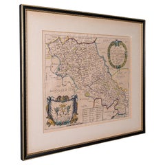
Antique Map Of Lovanium By Bleau Circa 1640
$475.30
£353.33
€400
CA$653.80
A$728.43
CHF 384.18
MX$8,831.02
NOK 4,887.27
SEK 4,552.80
DKK 3,047.38
About the Item
map of the brabent of leuven (Belgium) circa 1640 by Bléau. Bléau was well known for antique atlas that he draw during the 17 century
beautiful map, double page folded in the middle, which was part of the large atlas of Blaeu
Very beautiful colors
Beautiful mahogany frame
- Dimensions:Height: 24.81 in (63 cm)Width: 29.14 in (74 cm)Depth: 0.4 in (1 cm)
- Style:Renaissance (Of the Period)
- Materials and Techniques:
- Place of Origin:
- Period:
- Date of Manufacture:17 century
- Condition:Wear consistent with age and use.
- Seller Location:Brussels, BE
- Reference Number:1stDibs: LU4729242677732
About the Seller
4.9
Vetted Professional Seller
Every seller passes strict standards for authenticity and reliability
Established in 1988
1stDibs seller since 2019
166 sales on 1stDibs
Typical response time: 4 hours
- ShippingRetrieving quote...Shipping from: Bruxelles, Belgium
- Return Policy
Authenticity Guarantee
In the unlikely event there’s an issue with an item’s authenticity, contact us within 1 year for a full refund. DetailsMoney-Back Guarantee
If your item is not as described, is damaged in transit, or does not arrive, contact us within 7 days for a full refund. Details24-Hour Cancellation
You have a 24-hour grace period in which to reconsider your purchase, with no questions asked.Vetted Professional Sellers
Our world-class sellers must adhere to strict standards for service and quality, maintaining the integrity of our listings.Price-Match Guarantee
If you find that a seller listed the same item for a lower price elsewhere, we’ll match it.Trusted Global Delivery
Our best-in-class carrier network provides specialized shipping options worldwide, including custom delivery.More From This Seller
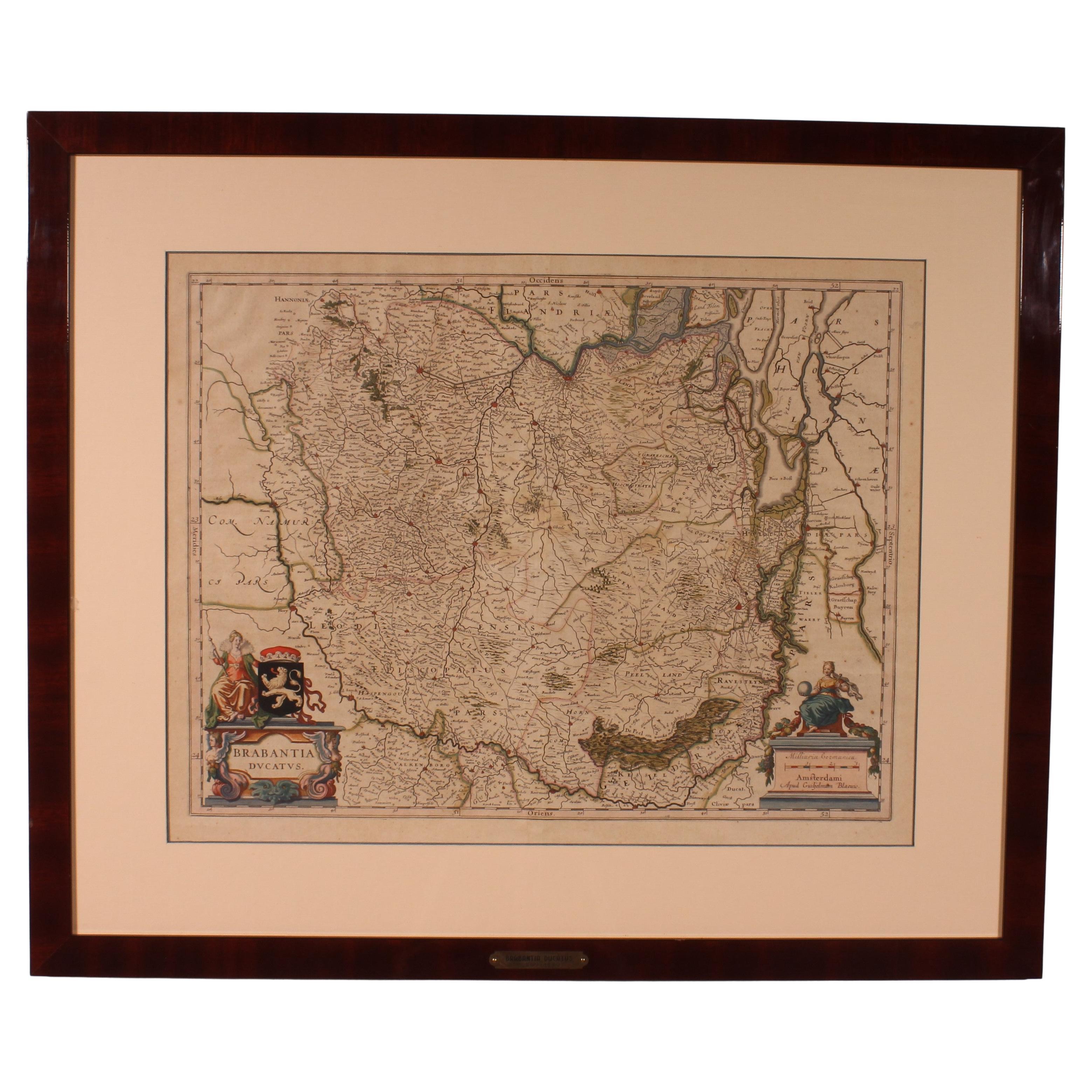
View AllAntique Map Of Brabantia Ducantus By Bleau Circa 1640
Located in Brussels, Brussels
map of theBrabantia Ducantus (Belgium) circa 1640 by Bléau. Bléau was well known for antique atlas that he draw during the 17 century
beautiful map, double page folded in the middle,...
Category
Antique 17th Century French Renaissance Maps
Materials
Paper

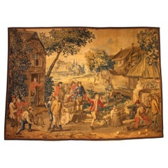
Brussels Tapestry After Teniers, circa 1700
Located in Brussels, Brussels
Brussels Tapestry After Teniers from the beginning of the 18th century
Very beautiful tapestry describing a village scene at the end of the 17th ce...
Category
Antique Early 18th Century Belgian Louis XIV Tapestries
Materials
Wool
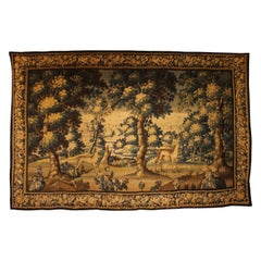
Verdure Tapestry From Flanders From The 17th Century
Located in Brussels, Brussels
Very beautiful tapestry describing a verdure from the end of the 17th century/beginning of the 18th century from the Flanders
Elegant tapestry representing a deer and a doe in the f...
Category
Antique Late 17th Century Belgian Louis XIV Tapestries
Materials
Wool
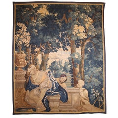
Felmish Tapistry 17th Century from Brugge
Located in Brussels, Brussels
Fine Flemish tapestry from Brugge from the 17th century
This fine tapestry depicting a mythological scene of a woman spied by two old men.
Very inte...
Category
Antique 17th Century Belgian Renaissance Tapestries
Materials
Wool
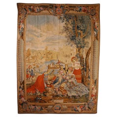
French Tapestry - Allegory Of Spring
Located in Brussels, Brussels
Lovely tapestry depicting the allegory of spring.
Very beautiful tapestry with a magnificent border.
It has retained its superb color.
In perfect condition.
Category
Early 20th Century French Louis XV Tapestries
Materials
Wool
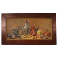
Painting By H. Coulon-19th Century
Located in Brussels, Brussels
oil on canvas representing a still life with fruits, flowers and game in a wooden frame signed H.Coulon
Large model
In good condition and beautiful patina
Category
Antique 19th Century French Aesthetic Movement Paintings
Materials
Wood
You May Also Like
Antique County Map of Cheshire, Dutch, Framed, Cartography, Janssonius, C.1660
Located in Hele, Devon, GB
This is an antique county map of Cheshire. A Dutch, framed atlas engraving by Johannes Janssonius, dating to the 17th century and later.
A treat for the collector or county native,...
Category
Antique Mid-17th Century Dutch Charles II Maps
Materials
Glass, Wood, Paper

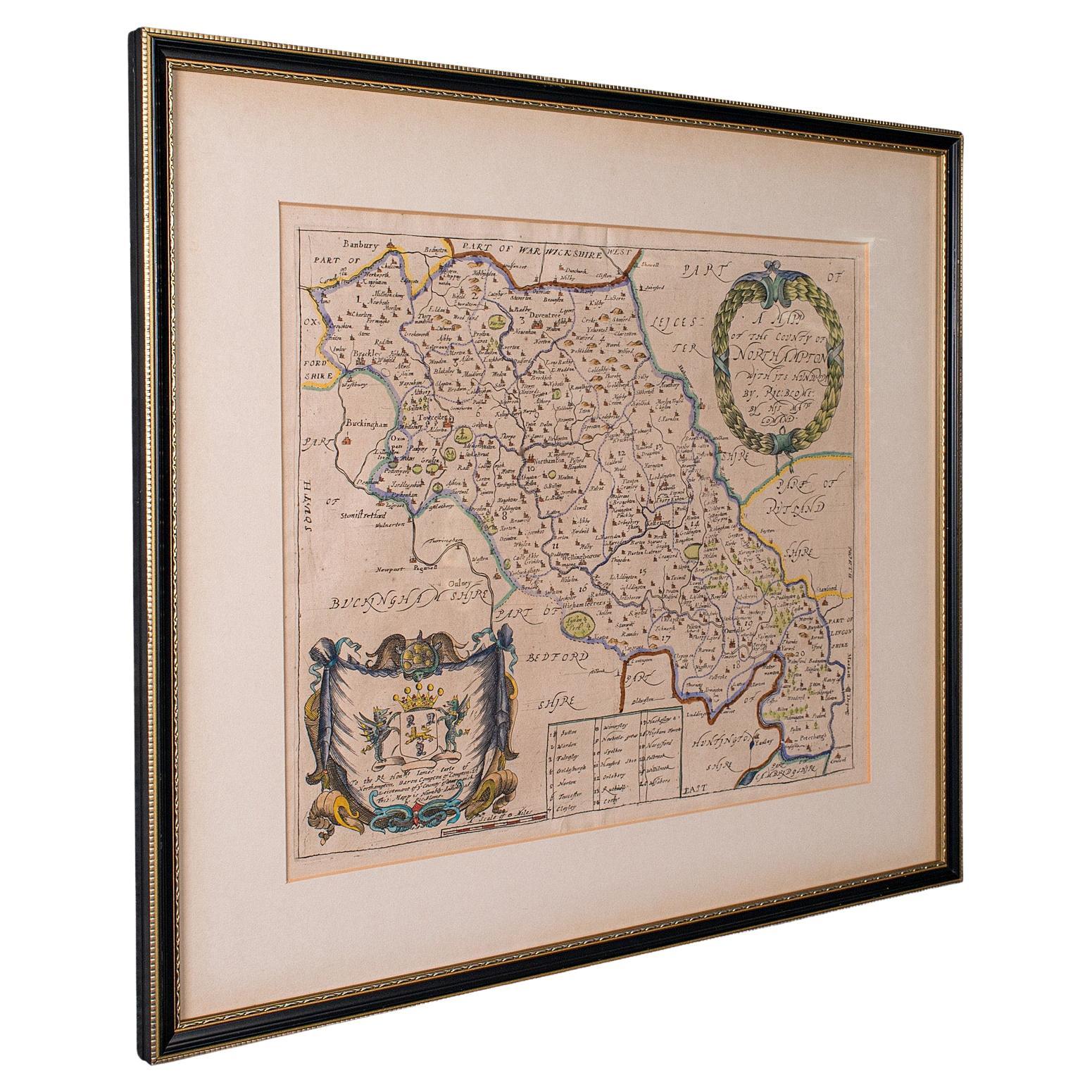
Antique County Map, Northamptonshire, English, Framed Cartography, Richard Blome
Located in Hele, Devon, GB
This is an antique county map of Northamptonshire. An English, framed atlas engraving by Richard Blome, dating to the 17th century and later.
Fascinating cartography, oriented 90 d...
Category
Antique Late 17th Century British Charles II Maps
Materials
Glass, Wood, Paper
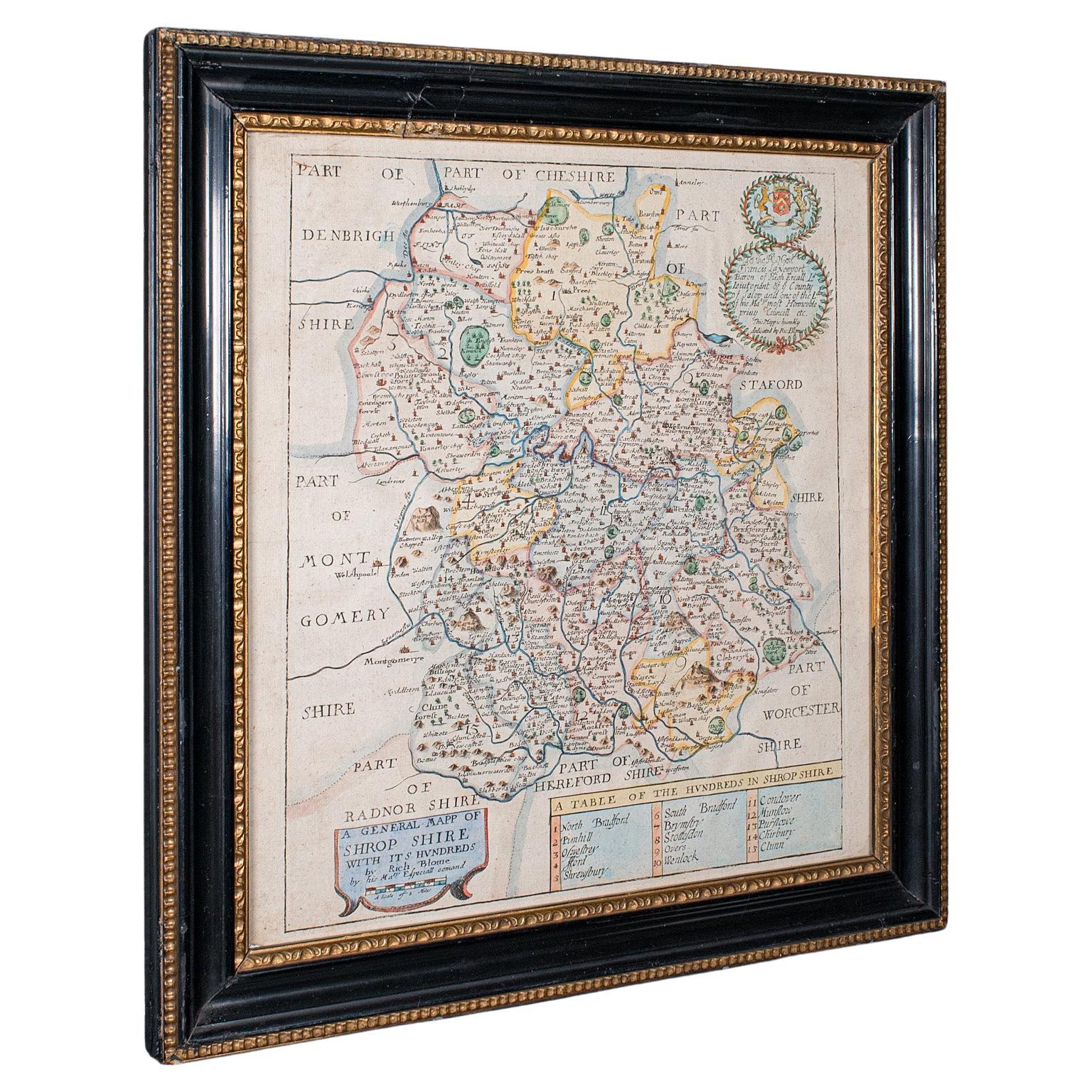
Antique County Map, Shropshire, English, Atlas Engraving, Richard Blome, C.1673
Located in Hele, Devon, GB
This is an antique county map of Shropshire. An English, framed atlas engraving by Richard Blome, dating to the 17th century and later.
A treat for the collector or county native, ...
Category
Antique 17th Century British Restauration Maps
Materials
Glass, Wood, Paper

Antique Map of Essex by Overton, circa 1710
Located in Langweer, NL
Antique map titled 'Essex, devided into Hundreds, with the most antient and fayre Towne Colchester (..)'. Map of Essex, England. Includes an inset town pl...
Category
Antique Early 18th Century Maps
Materials
Paper

$903 Sale Price
20% Off
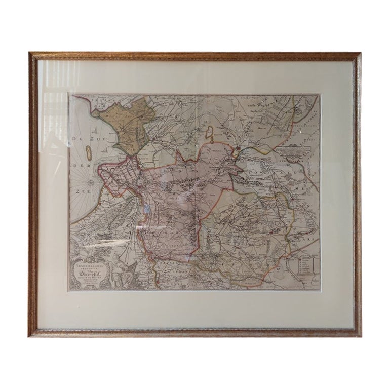
Antique Map of Overijssel by Visscher, c.1660
Located in Langweer, NL
Antique map titled 'Transisalania provincia vulgo Over-yssel'. Original antique map of the province of Overijssel, the Netherlands. Published by N. Visscher after N. ten Have, circa ...
Category
Antique 17th Century Maps
Materials
Paper

$701 Sale Price
20% Off
Antique Map of the Region of Bourbonnais by Janssonius, circa 1640
Located in Langweer, NL
Antique map titled 'Bourbonois - Borbonium Ducatus'. Old map of the former region of Bourbonnais, France. It includes the cities of Bourbon, Moulins, Charenton, Brulles, Varennes and...
Category
Antique Mid-17th Century Maps
Materials
Paper

$475 Sale Price
20% Off
More Ways To Browse
Blaeu Wall Map
1960s French Elephant
7 Star Flag
9 Foot Mirror
Alexander Lamont
Aluminum Sphere Sculpture
Angel Kneeling
Animal Sculpture Dog Bronze Mene
Antique Asian 4 Panel Screen
Antique Desk Boston
Antique Dish Cabinet
Antique Dog Sculpture Statue
Antique Hoe
Antique Horse On Wheels
Antique House Jack
Antique Industrial Cart
Antique Jacobean Chest Of Drawers
Antique Japanese Altar