Items Similar to Antique Plan and View of Saint-Louis, Senegal, Africa, 1746
Want more images or videos?
Request additional images or videos from the seller
1 of 6
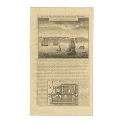
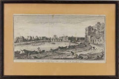
Antique Plan and View of Saint-Louis, Senegal, Africa, 1746
$287.38
$359.2220% Off
£212.43
£265.5420% Off
€240
€30020% Off
CA$390.85
CA$488.5620% Off
A$437.95
A$547.4320% Off
CHF 227.97
CHF 284.9620% Off
MX$5,357.59
MX$6,696.9920% Off
NOK 2,893.62
NOK 3,617.0320% Off
SEK 2,732.99
SEK 3,416.2420% Off
DKK 1,827.48
DKK 2,284.3520% Off
Shipping
Retrieving quote...The 1stDibs Promise:
Authenticity Guarantee,
Money-Back Guarantee,
24-Hour Cancellation
About the Item
Antique print titled ‘The Prospect of the Habitation of the French Senegal Company’. Plan and view of Saint-Louis, Senegal, Africa. This print originates from 'A Collection of Voyages and Travels (..)'.
Artists and Engravers: Published by Churchill.
Condition: Fair. Age-related toning. Please study image carefully.
Date: 1746
Overall size: 21.5 x 34.5 cm.
Image size: 15.5 x 24.5 cm.
We sell original antique maps to collectors, historians, educators and interior decorators all over the world. Our collection includes a wide range of authentic antique maps from the 16th to the 20th centuries. Buying and collecting antique maps is a tradition that goes back hundreds of years. Antique maps have proved a richly rewarding investment over the past decade, thanks to a growing appreciation of their unique historical appeal. Today the decorative qualities of antique maps are widely recognized by interior designers who appreciate their beauty and design flexibility. Depending on the individual map, presentation, and context, a rare or antique map can be modern, traditional, abstract, figurative, serious or whimsical. We offer a wide range of authentic antique maps for any budget.
- Dimensions:Height: 13.59 in (34.5 cm)Width: 8.47 in (21.5 cm)Depth: 0 in (0.01 mm)
- Materials and Techniques:
- Period:
- Date of Manufacture:1746
- Condition:Condition: Fair. Age-related toning. Please study image carefully.
- Seller Location:Langweer, NL
- Reference Number:Seller: BGI-00536'1stDibs: LU3054329260862
About the Seller
5.0
Recognized Seller
These prestigious sellers are industry leaders and represent the highest echelon for item quality and design.
Platinum Seller
Premium sellers with a 4.7+ rating and 24-hour response times
Established in 2009
1stDibs seller since 2017
2,494 sales on 1stDibs
Typical response time: 1 hour
- ShippingRetrieving quote...Shipping from: Langweer, Netherlands
- Return Policy
Authenticity Guarantee
In the unlikely event there’s an issue with an item’s authenticity, contact us within 1 year for a full refund. DetailsMoney-Back Guarantee
If your item is not as described, is damaged in transit, or does not arrive, contact us within 7 days for a full refund. Details24-Hour Cancellation
You have a 24-hour grace period in which to reconsider your purchase, with no questions asked.Vetted Professional Sellers
Our world-class sellers must adhere to strict standards for service and quality, maintaining the integrity of our listings.Price-Match Guarantee
If you find that a seller listed the same item for a lower price elsewhere, we’ll match it.Trusted Global Delivery
Our best-in-class carrier network provides specialized shipping options worldwide, including custom delivery.More From This Seller
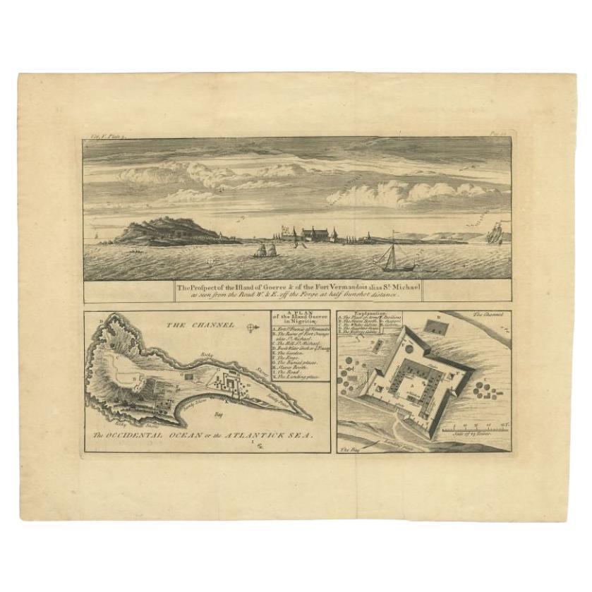
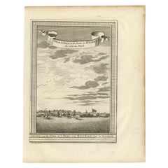
View AllAntique Plan and Views of Gorée Island, Dakar, Senegal, 1746
Located in Langweer, NL
Antique print titled 'The Prospect of the Island of Goeree & The Fort Vermandois alias St. Michael (..)’. Plan and view of Gorée Island, Dakar, Senegal. This print originates from 'A...
Category
Antique 18th Century Prints
Materials
Paper
$344 Sale Price
20% Off
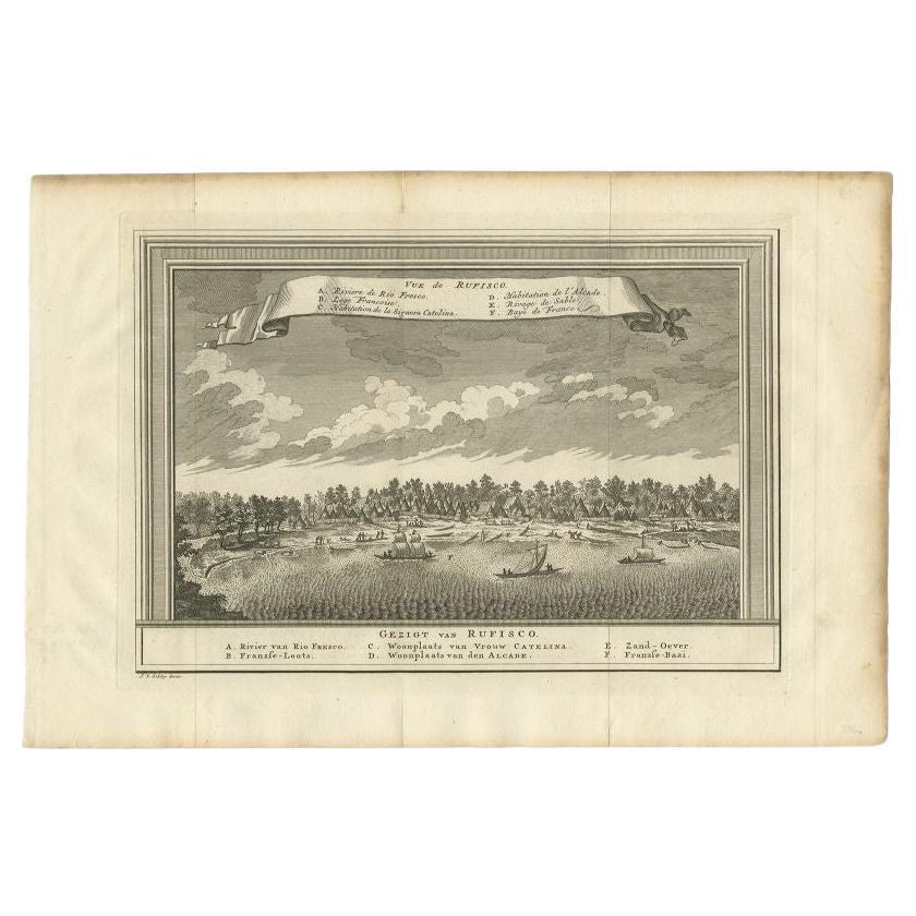
Antique Print with a View of Rufisque, Dakar, Senegal, 1747
By Jakob van der Schley
Located in Langweer, NL
Antique print titled 'Vue de Rufisco - Gezigt van Rufisco'. View of Rufisque, Dakar, Senegal. This print originates from 'Historische beschryving der reizen, of Nieuwe en volkoome ve...
Category
Antique 18th Century Prints
Materials
Paper
$210 Sale Price
20% Off
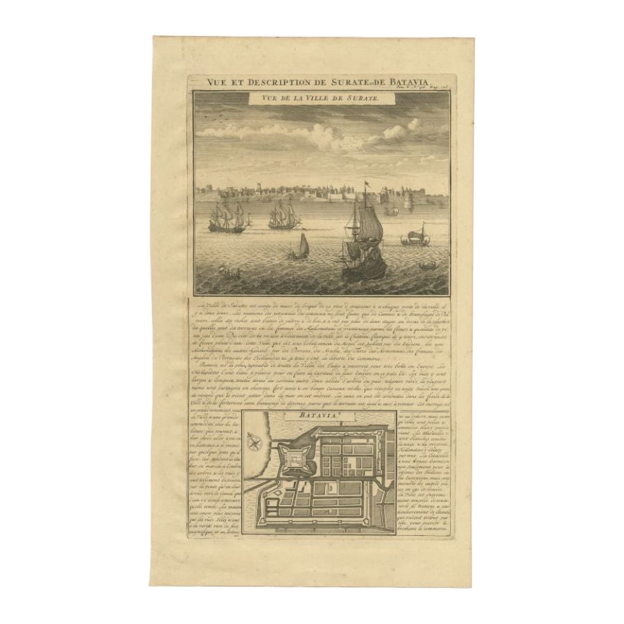
Antique Print of Surate and a Plan of Batavia in the Dutch East Indies, 1719
Located in Langweer, NL
Antique print titled 'Vue et Description de Surate et de Batavia'. Attractive view of the town and harbor of Surate on the northwest coast of India, and a bird's-eye city plan of Bat...
Category
Antique 18th Century Prints
Materials
Paper
$316 Sale Price
20% Off
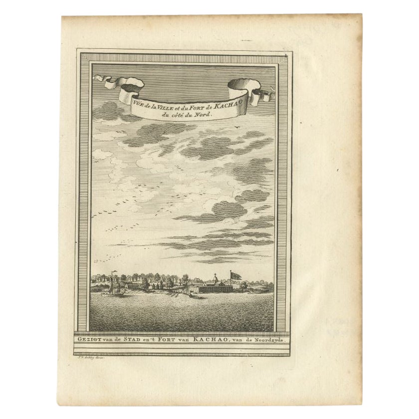
Antique Print of the City and Fortress of Kachao in Guinea Bissau, Africa, 1747
By Jakob van der Schley
Located in Langweer, NL
Antique print titled 'Gezigt van de Stad en 't Fort van Kachao'. View of the city and Fortress of Kachao, Guinea Bissau, Africa. Engraved by J. van Schley for a Dutch edition of 'l'H...
Category
Antique 18th Century Prints
Materials
Paper
$220 Sale Price
20% Off
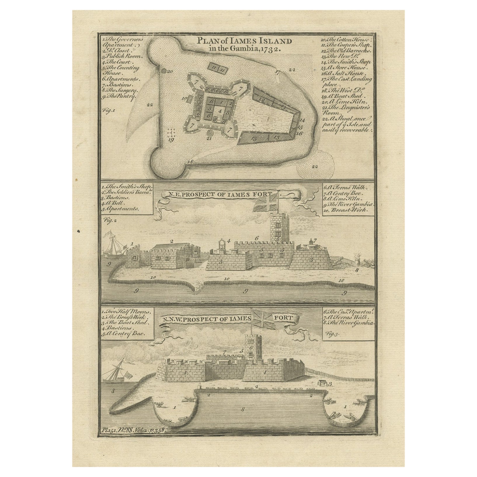
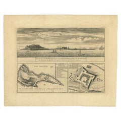
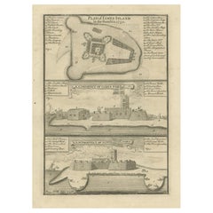
Antique Print with a Plan of Kunta Kinteh Island and views of Fort James, Gambia
Located in Langweer, NL
Antique print titled 'Plan of Iames Island in the Gambia - N.E. Prospect of Iames Fort - N.N.W. Prospect of Iames Fort'. Print with a plan of Kunta Kinteh I...
Category
Antique Mid-18th Century Prints
Materials
Paper
$210 Sale Price
20% Off
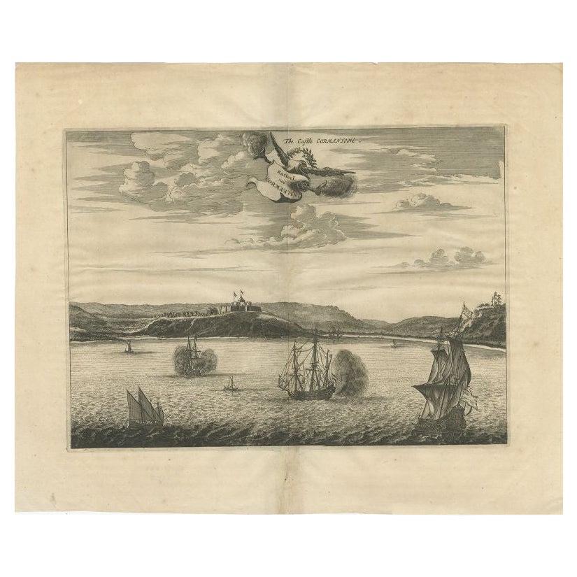
Antique Print of a Fort on the Gold Coast of Africa by Dapper, c.1670
Located in Langweer, NL
`Antique print titled 'Kasteel van Cormantin/The castle Cormantine'. Fine engraving depicting one of the forts on the Gold Coast of Africa. Cormantine Castle first was a British fort...
Category
Antique 17th Century Prints
Materials
Paper
You May Also Like
18th Century French Map and City View of Joppe/Jaffa (Tel Aviv) by Sanson
By Nicholas Sanson d'Abbeville
Located in Alamo, CA
An original antique engraving entitled "Joppe; in ’t Hebreeusch by ouds Japho; hedendaags Japha, of Jaffa; volgens d’aftekening gedaan 1668", by Nicholas Sanson d'Abbeville (1600 - 1667). This is a view of the city of Joppe (in Hebrew Japho), now called Japha or Jaffa, the harbor portion of modern day Tel Aviv, Israel as it appeared in 1668 . It depicts a very busy harbor with numerous boats. A large ship on the left appears to be firing its canons and a small ship on the right appears to be sitting very low in the water, either heavily loaded with cargo or sinking. The town is seen on the far shore with a fortress on a hill across in the background. The map is printed from the original Sanson copperplate and was published in 1709 by his descendants.
The map is presented in an ornate brown wood frame embellished by gold-colored leaves and gold inner trim with a double mat; the outer mat is cream-colored and the inner mat is black. There is a central vertical fold, as issued. There are two small spots in the lower margin and one in the upper margin, as well as two tiny spots adjacent to the central fold. 1717 is written below the date 1668 in the inscription. The map is otherwise in very good condition.
Another map of the "Holy Land" (by Claes Visscher in 1663), with an identical style frame and mat is available. This pair of maps would make a wonderful display grouping. Please see Reference #LU117324709892.
Artist: Nicholas Sanson d'Abbeville (1600 - 1667) and his descendents were important French cartographer's active through the 17th century. Sanson started his career as a historian and initially utilized cartography to illustrate his historical treatises. His maps came to the attention of Cardinal Richelieu and then King Louis XIII of France, who became a supporter and sponsor. He subsequently appointed Sanson 'Geographe Ordinaire du Roi' the official map maker to the king. Sanson not only created maps for the king, but advised him on geographical issues and curated his map collection...
Category
Early 1700s Prints and Multiples
Materials
Engraving

18th Century French Map and City View of Joppe/Jaffa 'Tel Aviv' by Sanson
By Nicolas Sanson
Located in Alamo, CA
An original antique engraving entitled "Joppe; in ’t Hebreeusch by ouds Japho; hedendaags Japha, of Jaffa; volgens d’aftekening gedaan 1668", by Nicholas Sanson d'Abbeville (1600 - 1667). This is a view of the city of Joppe (in Hebrew Japho), now called Japha or Jaffa, the harbor portion of modern day Tel Aviv, Israel as it appeared in 1668 . It depicts a very busy harbor with numerous boats. A large ship on the left appears to be firing its canons and a small ship on the right appears to be sitting very low in the water, either heavily loaded with cargo or sinking. The town is seen on the far shore with a fortress on a hill across in the background. The map is printed from the original Sanson copperplate and was published in 1709 by his descendants.
The map is presented in an ornate brown wood frame embellished by gold-colored leaves and gold inner trim with a double mat; the outer mat is cream-colored and the inner mat is black. There is a central vertical fold, as issued. There are two small spots in the lower margin and one in the upper margin, as well as two tiny spots adjacent to the central fold. 1717 is written below the date 1668 in the inscription. The map is otherwise in very good condition.
Another map of the "Holy Land" (by Claes Visscher in 1663), with an identical style frame and mat is available. This pair of maps would make a wonderful display grouping. Please see Reference #LU5206220653552. A discount is available for the purchase of the pair of maps.
Artist: Nicholas Sanson d'Abbeville (1600-1667) and his descendents were important French cartographer's active through the 17th century. Sanson started his career as a historian and initially utilized cartography to illustrate his historical treatises. His maps came to the attention of Cardinal Richelieu and then King Louis XIII of France, who became a supporter and sponsor. He subsequently appointed Sanson 'Geographe Ordinaire du Roi' the official map maker to the king. Sanson not only created maps for the king, but advised him on geographical issues and curated his map collection...
Category
Antique Early 18th Century French Maps
Materials
Paper

View of the City of Paris from the side of the island called... - Etching - 1748
Located in Roma, IT
Etching on paper realized in 1748.
Very good condition except for some minor foxing.
Includes a wooden frame cm. 27.5x41.5
Category
1740s Modern Abstract Prints
Materials
Etching
17th Century Toulouse, Savve, Sommieres Topographical Map by Iohan Peeters
Located in New York, NY
Fine topographical 17th century map of Toulouse, Savve and Sommieres by Iohan Peeters
Beautiful engraving of the capital of France's Occitanie Region, Toulouse, called La Ville Rose- the Pink City, for the terracotta bricks used in its many buildings, giving the city a distinct apricot-rose hue. An important cultural and educational center, the city's residents included Nobel Prize winners and world renown artists- Henri de Toulouse-Lautrec, Henri Martin, Jean-Auguste-Dominique Ingres, Antonin Mercie, Alexandre Falguiere and more recently Cyril Kongo...
Category
Antique 17th Century Dutch Maps
Materials
Paper

17th-18th Century Siege of Graves Mapping Engraving By Willian III
Located in Kingston, NY
RARE French 17th-18th Century Enhanced Siege of Graves Mapping Engraving BY William III, also widely known as William of Orange,
The Siege of Grave in Dutch Brabant started by Monsie...
Category
Antique 17th Century French Prints
Materials
Paper

Antique Voc Print Holland Malaysia Old Map Melaka History, 1663
Located in Amsterdam, Noord Holland
From my own collection I offer this impressive Antique print of the city of Malakka
A very interesting piece for collectors . It is an museum piece from the Dutch Institute of Orien...
Category
Antique 17th Century European Paintings
Materials
Paper

$293 Sale Price
20% Off
More Ways To Browse
Antique Mahogany 4 Drawer Chest
Antique Oak Bow Front Cabinet
Antique Pine China Cabinet
Antique Primitive Chest
Antique Rosewood Dresser
Antique Seahorse
Antique Shell Bottles
Antique Silver New Orleans
Antique Spice Cabinet
Antique Whippet
Art Deco Dragonfly
Art Deco Folding Bar
Art Glass Duck Sculpture
Art Nouveau Compote
Asian Wall Cabinets
Ave Maria
Balinese Hand Carved
Barre Bronze