Items Similar to Antique Print of the Planetary Systems of the World by Levasseur, '1875'
Want more images or videos?
Request additional images or videos from the seller
1 of 5
Antique Print of the Planetary Systems of the World by Levasseur, '1875'
$480.39
$600.4920% Off
£353.81
£442.2620% Off
€400
€50020% Off
CA$653.54
CA$816.9220% Off
A$726.23
A$907.7820% Off
CHF 380.55
CHF 475.6920% Off
MX$8,905.87
MX$11,132.3420% Off
NOK 4,853.70
NOK 6,067.1220% Off
SEK 4,566.18
SEK 5,707.7220% Off
DKK 3,045.14
DKK 3,806.4220% Off
Shipping
Retrieving quote...The 1stDibs Promise:
Authenticity Guarantee,
Money-Back Guarantee,
24-Hour Cancellation
About the Item
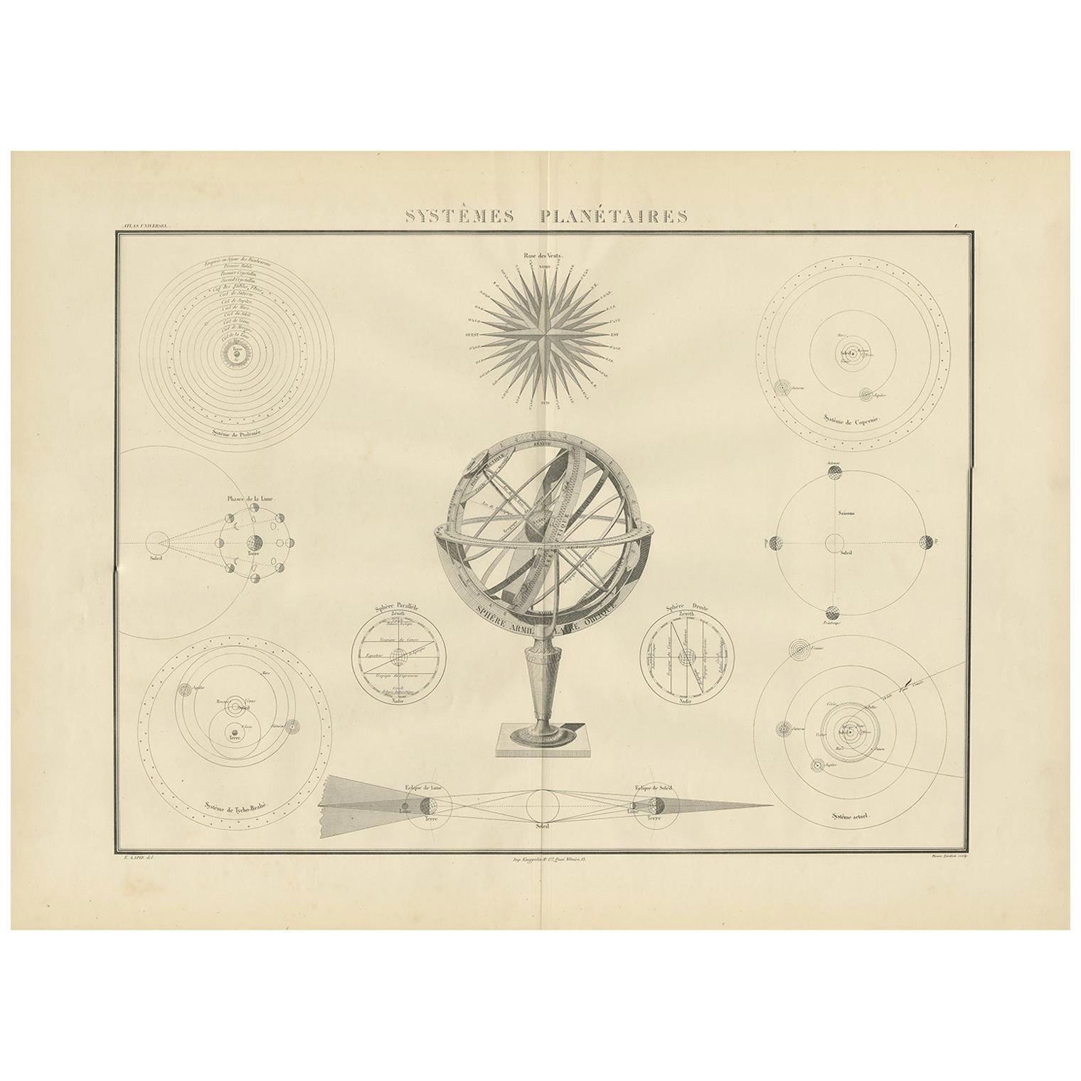
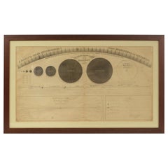
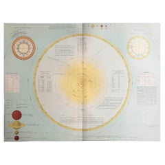
Antique print titled 'Tableau Synthétique de Cosmographie'. Large print depicting the planetary systems of the world. This map originates from 'Atlas de Géographie Moderne Physique et Politique' by A. Levasseur. Published, 1875.
- Dimensions:Height: 18.71 in (47.5 cm)Width: 24.02 in (61 cm)Depth: 0.02 in (0.5 mm)
- Materials and Techniques:
- Period:
- Date of Manufacture:1875
- Condition:General age-related toning, minor wear. Few small holes, also affecting image. Original folding line, blank verso. Please study images carefully.
- Seller Location:Langweer, NL
- Reference Number:Seller: BG-12257-11stDibs: LU3054320221802
About the Seller
5.0
Recognized Seller
These prestigious sellers are industry leaders and represent the highest echelon for item quality and design.
Platinum Seller
Premium sellers with a 4.7+ rating and 24-hour response times
Established in 2009
1stDibs seller since 2017
2,494 sales on 1stDibs
Typical response time: 1 hour
- ShippingRetrieving quote...Shipping from: Langweer, Netherlands
- Return Policy
Authenticity Guarantee
In the unlikely event there’s an issue with an item’s authenticity, contact us within 1 year for a full refund. DetailsMoney-Back Guarantee
If your item is not as described, is damaged in transit, or does not arrive, contact us within 7 days for a full refund. Details24-Hour Cancellation
You have a 24-hour grace period in which to reconsider your purchase, with no questions asked.Vetted Professional Sellers
Our world-class sellers must adhere to strict standards for service and quality, maintaining the integrity of our listings.Price-Match Guarantee
If you find that a seller listed the same item for a lower price elsewhere, we’ll match it.Trusted Global Delivery
Our best-in-class carrier network provides specialized shipping options worldwide, including custom delivery.More From This Seller
View AllAntique Chart of Celestial and Scientific Models by Lapie, 1842
Located in Langweer, NL
Antique print titled 'Systèmes Planétaires'. Chart of various celestial and scientific models. Includes an armillary sphere and various models of the universe, the season, eclipses, a Copernican, Tycho...
Category
Antique Mid-19th Century French Prints
Materials
Paper
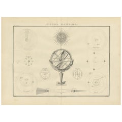
$720 Sale Price
25% Off
Antique Print of the World's Time Zones by Johnson, 1872
Located in Langweer, NL
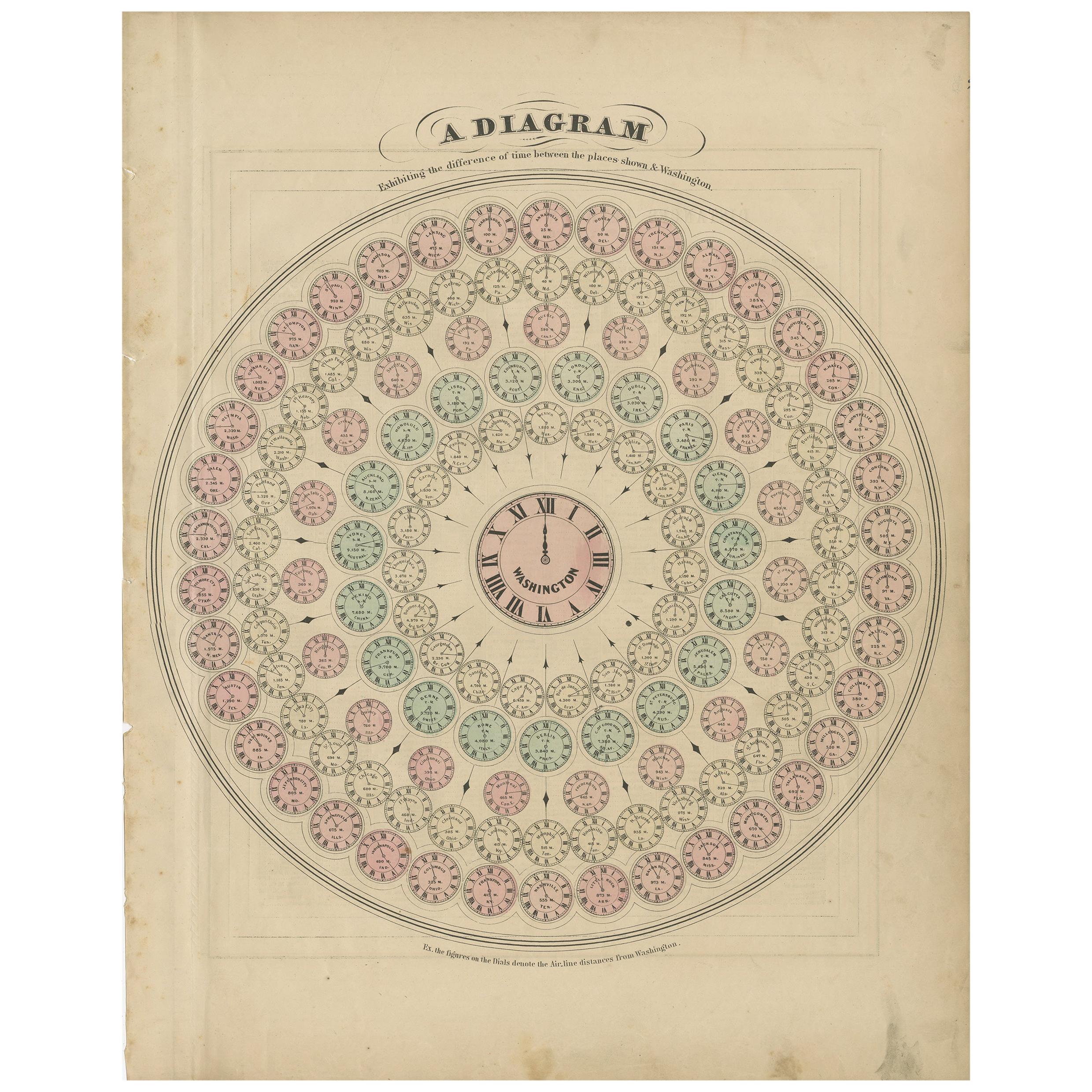
Antique print titled 'A Diagram exhibiting the difference of time between the places shown & Washington'. Original print of the World's time zones. This map originates from 'Johnson'...
Category
Antique Late 19th Century Prints
Materials
Paper
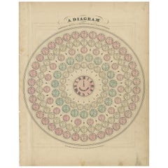
$288 Sale Price
20% Off
Antique Hemisphere Map of the World 'Two on One Sheet' by Levasseur, '1875'
Located in Langweer, NL
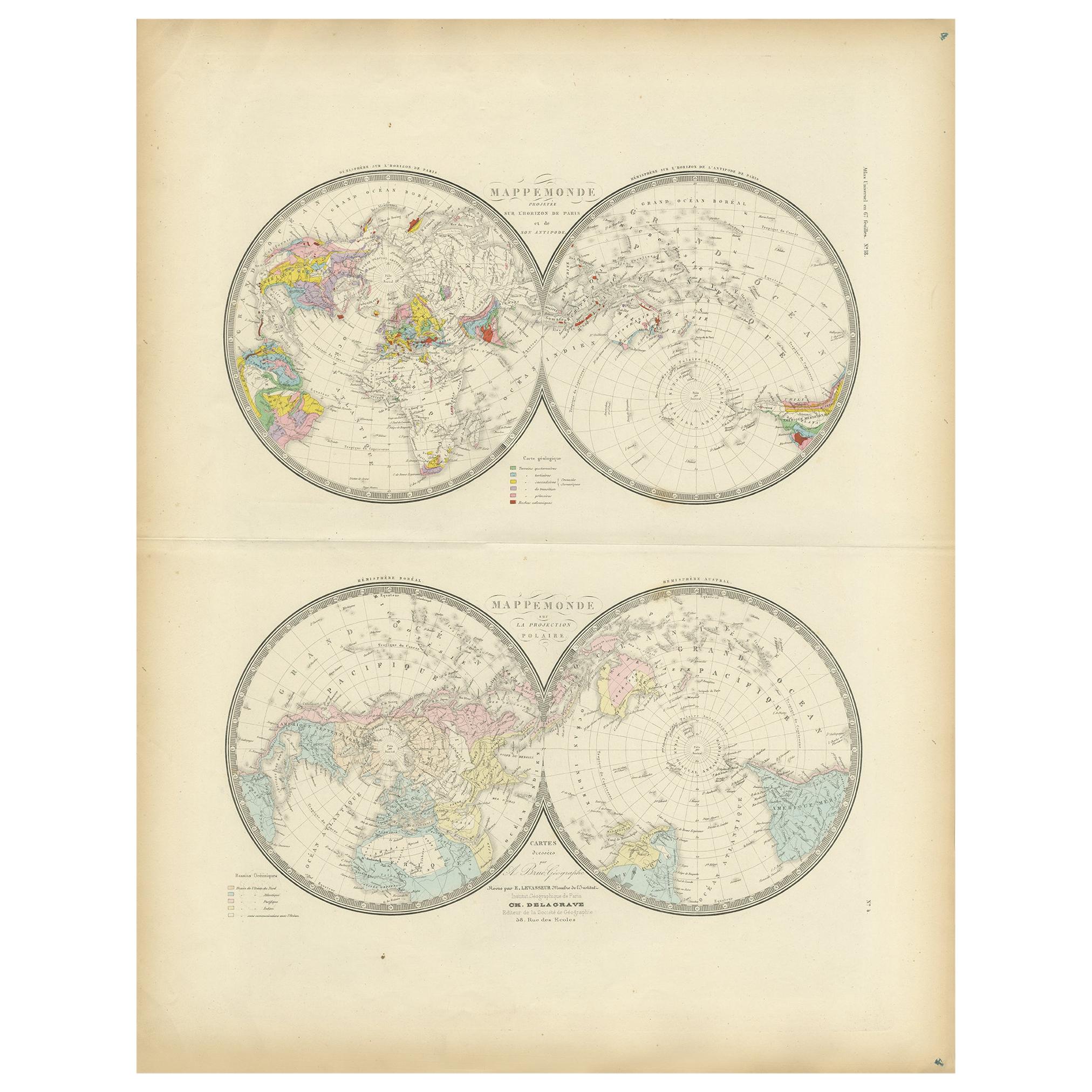
Antique map titled 'Mappemonde projetée sur l'Horizon de Paris et de son Antipode - Mappemonde sur la projection polaire'. Large map with two hemisphere world maps...
Category
Antique Late 19th Century Maps
Materials
Paper

$330 Sale Price
44% Off
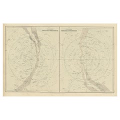
Antique Print of Celestial Hemispheres, 1854
Located in Langweer, NL
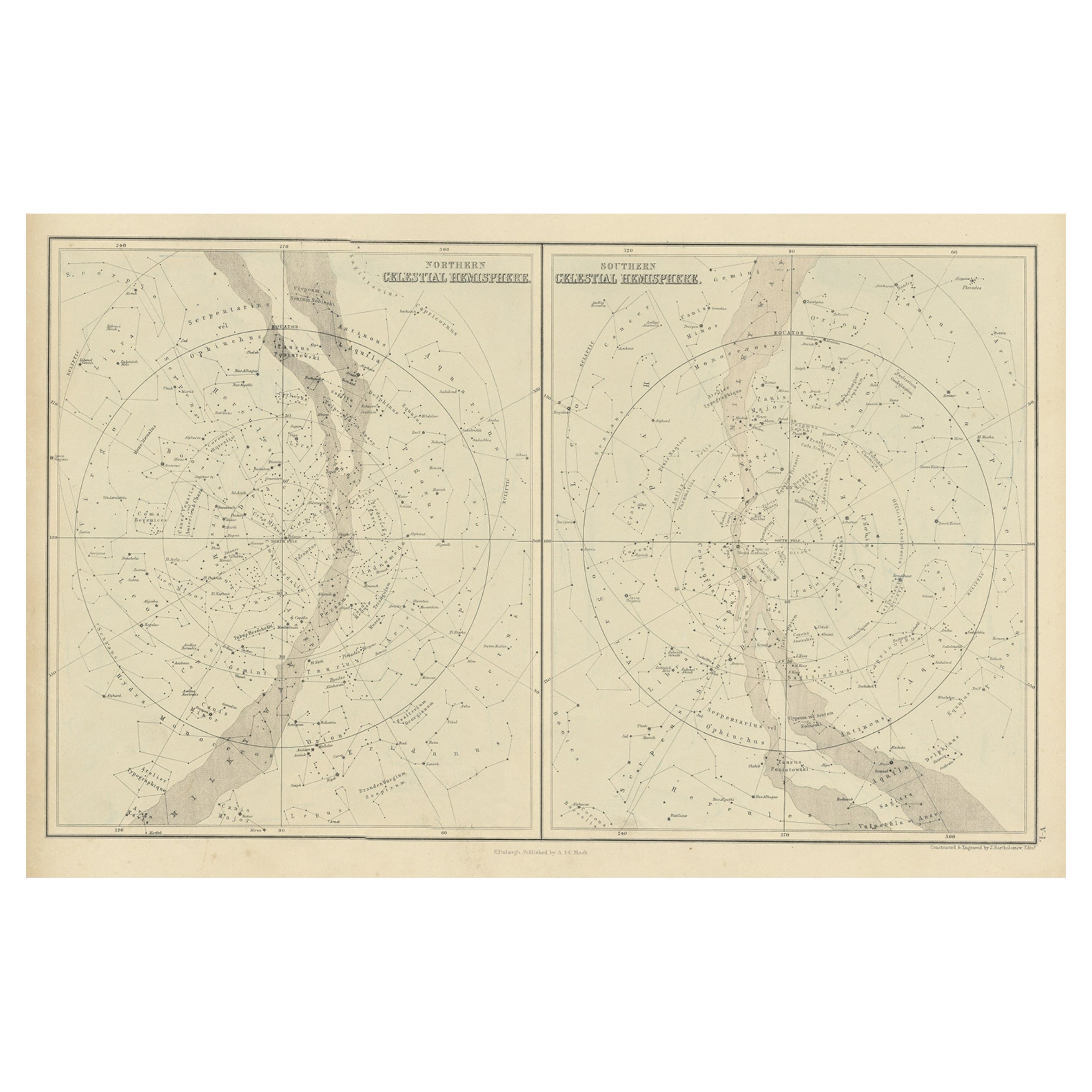
Antique world map titled 'Northern Celestial Hemisphere - Southern Celestial Hemisphere'. Old map with two charts of the celestial hemispheres. This map orginates from 'General Atlas...
Category
Antique 19th Century English Prints
Materials
Paper
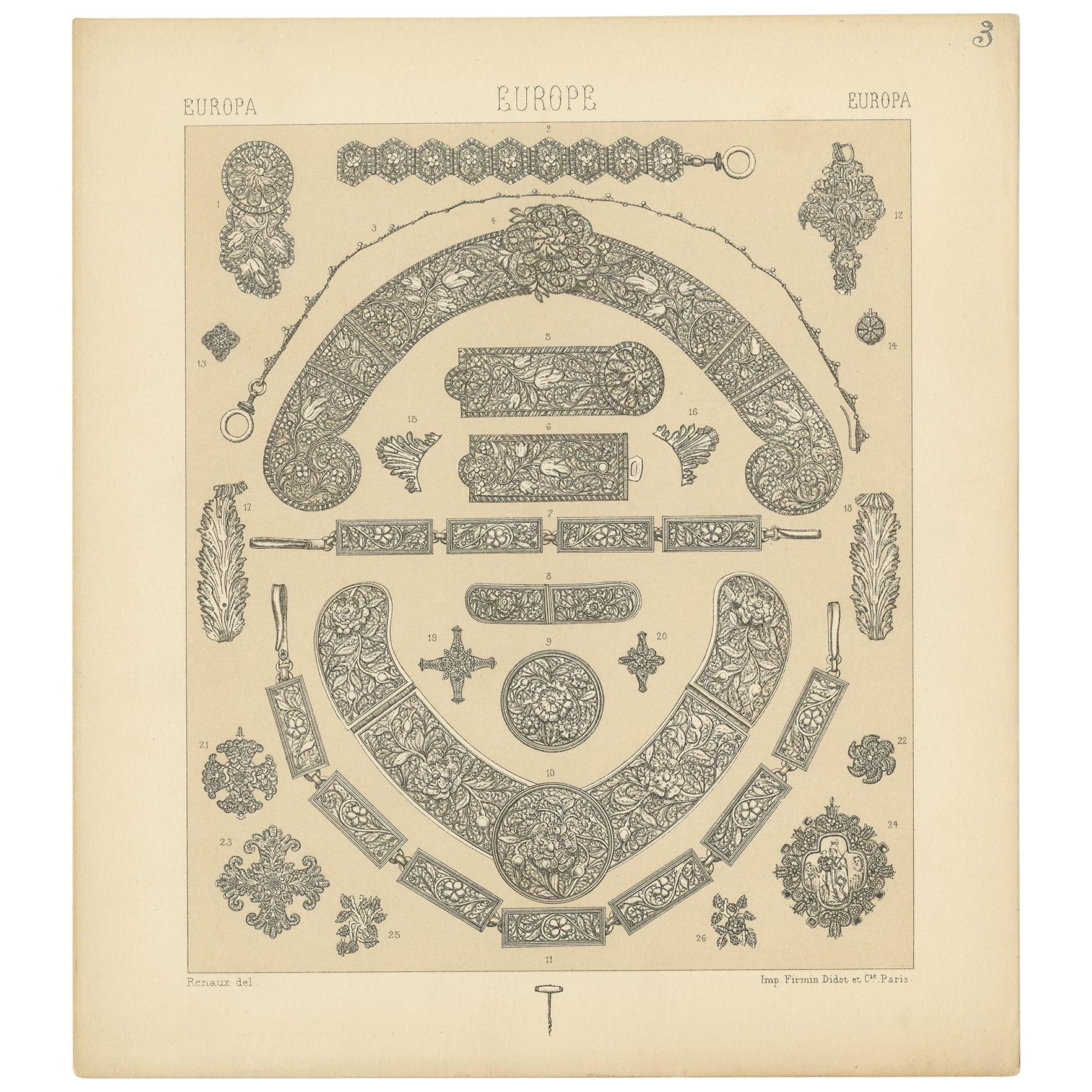
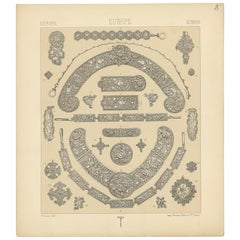
Pl 3 Antique Print of European Decorative Objects by Racinet, 'circa 1880'
Located in Langweer, NL
Antique print titled 'Europa- Europe - Europa'. Chromolithograph of European Decorative Objects. This print originates from 'Le Costume Historique' by M.A. Racinet. Published, circa ...
Category
Antique Late 19th Century Prints
Materials
Paper
$96 Sale Price
20% Off
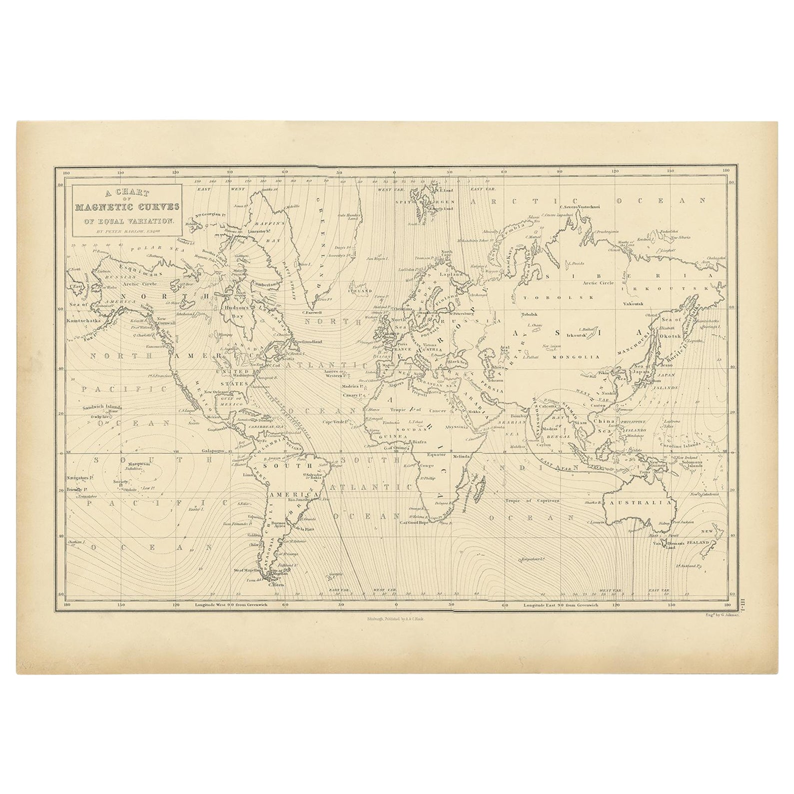
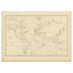
Antique Chart with Isomagnetic Lines by Black, 1854
Located in Langweer, NL
Antique map titled 'A Chart of Magnetic Curves of Equal Variation'. Chart with isomagnetic lines on continents, except for North America. This map orginates from 'General Atlas Of Th...
Category
Antique 19th Century Prints
Materials
Paper
$127 Sale Price
20% Off
You May Also Like
1855 Astronomical Plate of Distance of the Planets by FJ Huntington New York
Located in Milan, IT
Plate of the distance of the planets “Entered according to Act of Congress in the year 1855 by F.J. Huntington in the Clerk's Office of the District Court of the United States for th...
Category
Antique 1850s American Scientific Instruments
Materials
Glass, Wood, Paper
Original Antique Astronomy Print. C.1900
Located in St Annes, Lancashire
Great image of the solar system
Unframed.
Chromo-lithograph
Published, C.1900
The measurement is the paper size of the print
Free shipping.
Category
Antique Early 1900s English Folk Art Prints
Materials
Paper
Old Map Depicting the Entire Earth's Surface Divided into Six Parts France 1850
Located in Milan, IT
Map depicting the entire earth's surface divided into six parts which depicts the position of peoples on Earth based on the assumption that it is impossible for each people to have t...
Category
Antique Mid-19th Century French Maps
Materials
Glass, Wood, Paper

Histology - Lithograph by Vincenzo Tenore - 1870s
Located in Roma, IT
Lithograph.
Plate from "Atlante di Botanica popolare ossia Illustrazione di Piante Notevoli di ogni famiglia" (Atlas of popular botany or illustration of notable plants of each fami...
Category
1870s Modern Figurative Prints
Materials
Lithograph
20th Century Colorful Print in Frame Depicting Telescopes
Located in Opole, PL
20th Century Colorful Print in Frame Depicting Telescopes
One of the items from the series of several illustrations on different topics.
The engraving...
Category
20th Century European Prints
Materials
Paper
$132 Sale Price
44% Off
1850 Old French Map Depicting the Entire Earth's Surface Divided into Two Parts
Located in Milan, IT
Geographical map depicting the entire earth’s surface divided into two parts that correspond to the two hemispheres or globes, the map deals with the latitudes and longitudes, the me...
Category
Antique Mid-19th Century French Maps
Materials
Glass, Wood, Paper

More Ways To Browse
Francois Perrier
Henriette Ronner
Mirror Framed Botanical Prints
Nagel Serigraphs
Old Drexel Furniture
Patrick Nagel Original
Raphael Loggia
School Blackboard Vintage
Trajan Column Print
Antique Polearms
Antique Trunk Lithographs
Christian Wagner
Grey Partridge
J Hinton
La Mode Illustree
Peter Bull
Shriners Hat
Vintage Porn