Items Similar to Crossing the Bitter Root River in Western Montana, USA - Tinted Lithograph, 1856
Want more images or videos?
Request additional images or videos from the seller
1 of 6
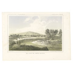
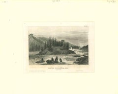
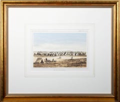
Crossing the Bitter Root River in Western Montana, USA - Tinted Lithograph, 1856
$263.59
£196.19
€220
CA$361.05
A$401.57
CHF 209.69
MX$4,886.70
NOK 2,678.04
SEK 2,511.53
DKK 1,674.78
Shipping
Retrieving quote...The 1stDibs Promise:
Authenticity Guarantee,
Money-Back Guarantee,
24-Hour Cancellation
About the Item
Title: Crossing the Bitter Root River - Tinted Lithograph from the Pacific Railroad Survey, 1856
Description:
This striking lithograph, "Crossing the Bitter Root River," captures a moment of exploration and movement in the American West. Published as General Report – Plate XXXIV in the Pacific Railroad Exploration Survey reports of 1856, the artwork showcases a group of travelers on horseback and pack animals as they ford the Bitter Root River, surrounded by dense forests and towering mountains.
The composition highlights the dramatic interaction between the rugged wilderness and the human element, with the river reflecting the surrounding trees and distant mountain peaks. The foreground features a fallen tree, emphasizing the raw and untamed nature of the landscape. This lithograph offers a vivid glimpse into the challenges and beauty encountered during westward exploration.
Created by Sarony, Major & Knapp, the lithograph is rendered in delicate tints and detailed linework, exemplifying the craftsmanship of 19th-century lithography. The play of light and shadow, combined with the soft color palette, gives depth and realism to the scene, making it both a historical document and a work of art.
The Bitter Root refers to the Bitterroot River and the Bitterroot Valley, located in western Montana. The river flows south to north through the valley, which is nestled between the Bitterroot Range of the Rocky Mountains to the west and the Sapphire Mountains to the east. The Bitterroot Range also forms part of the boundary between Montana and Idaho.
The area is named after the bitterroot plant (Lewisia rediviva), which was a significant food source for Native American tribes in the region. The valley and river hold historical significance, as they were part of the route used by the Lewis and Clark Expedition in 1805 and 1806, and later became a key location for westward migration.
Today, the Bitterroot Valley is known for its scenic beauty, outdoor recreation opportunities, and historical sites, including the location of Fort Owen, which was Montana's first permanent white settlement. The area remains a symbol of the rugged frontier and the spirit of exploration.
Condition: Very good, with minimal foxing on the margins. The image remains vibrant, with no visible damage or fading.
Framing Tip: Use a matte in a soft green or gray tone to enhance the natural hues of the lithograph. A rustic wooden frame or a simple metallic finish would complement the piece, making it a beautiful addition to any collection of Western Americana or historical landscapes.
- Dimensions:Height: 8.15 in (20.7 cm)Width: 11.15 in (28.3 cm)Depth: 0.01 in (0.2 mm)
- Materials and Techniques:
- Period:
- Date of Manufacture:1856
- Condition:Condition: Very good, with minimal foxing at the margins. The image is crisp, and the colors remain vivid and well-preserved.
- Seller Location:Langweer, NL
- Reference Number:Seller: BG-14038-261stDibs: LU3054343477242
About the Seller
5.0
Recognized Seller
These prestigious sellers are industry leaders and represent the highest echelon for item quality and design.
Platinum Seller
Premium sellers with a 4.7+ rating and 24-hour response times
Established in 2009
1stDibs seller since 2017
2,508 sales on 1stDibs
Typical response time: <1 hour
- ShippingRetrieving quote...Shipping from: Langweer, Netherlands
- Return Policy
Authenticity Guarantee
In the unlikely event there’s an issue with an item’s authenticity, contact us within 1 year for a full refund. DetailsMoney-Back Guarantee
If your item is not as described, is damaged in transit, or does not arrive, contact us within 7 days for a full refund. Details24-Hour Cancellation
You have a 24-hour grace period in which to reconsider your purchase, with no questions asked.Vetted Professional Sellers
Our world-class sellers must adhere to strict standards for service and quality, maintaining the integrity of our listings.Price-Match Guarantee
If you find that a seller listed the same item for a lower price elsewhere, we’ll match it.Trusted Global Delivery
Our best-in-class carrier network provides specialized shipping options worldwide, including custom delivery.More From This Seller
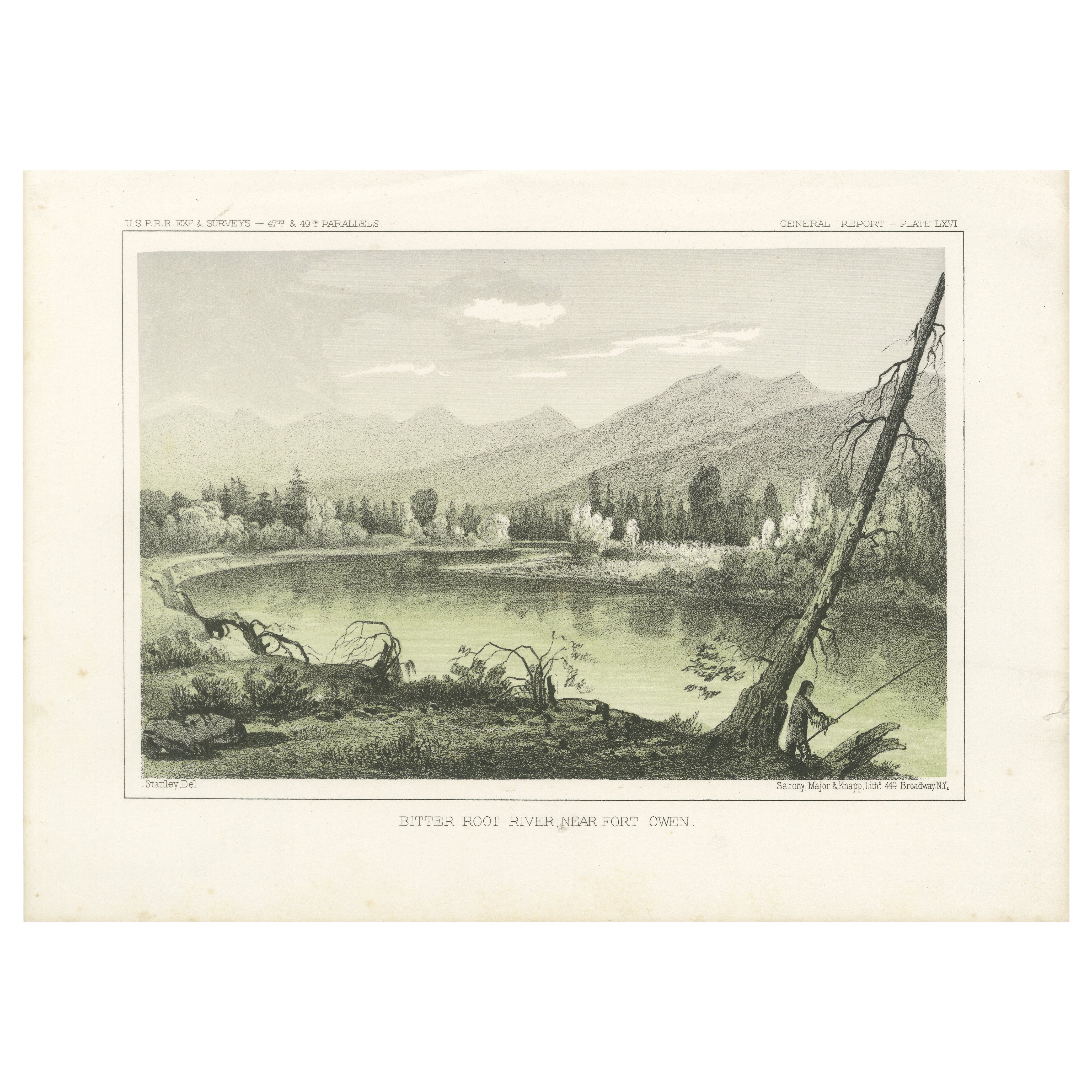
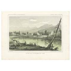
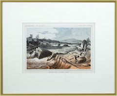
View AllBitter Root River Near Fort Owen in Montana - Tinted Lithograph of 1856
Located in Langweer, NL
Title: Bitter Root River Near Fort Owen in Montana - Tinted Lithograph from the Pacific Railroad Survey, 1856
Description:
This stunning lithograph, "Bitter Root River Near Fort...
Category
Antique 1850s Prints
Materials
Paper
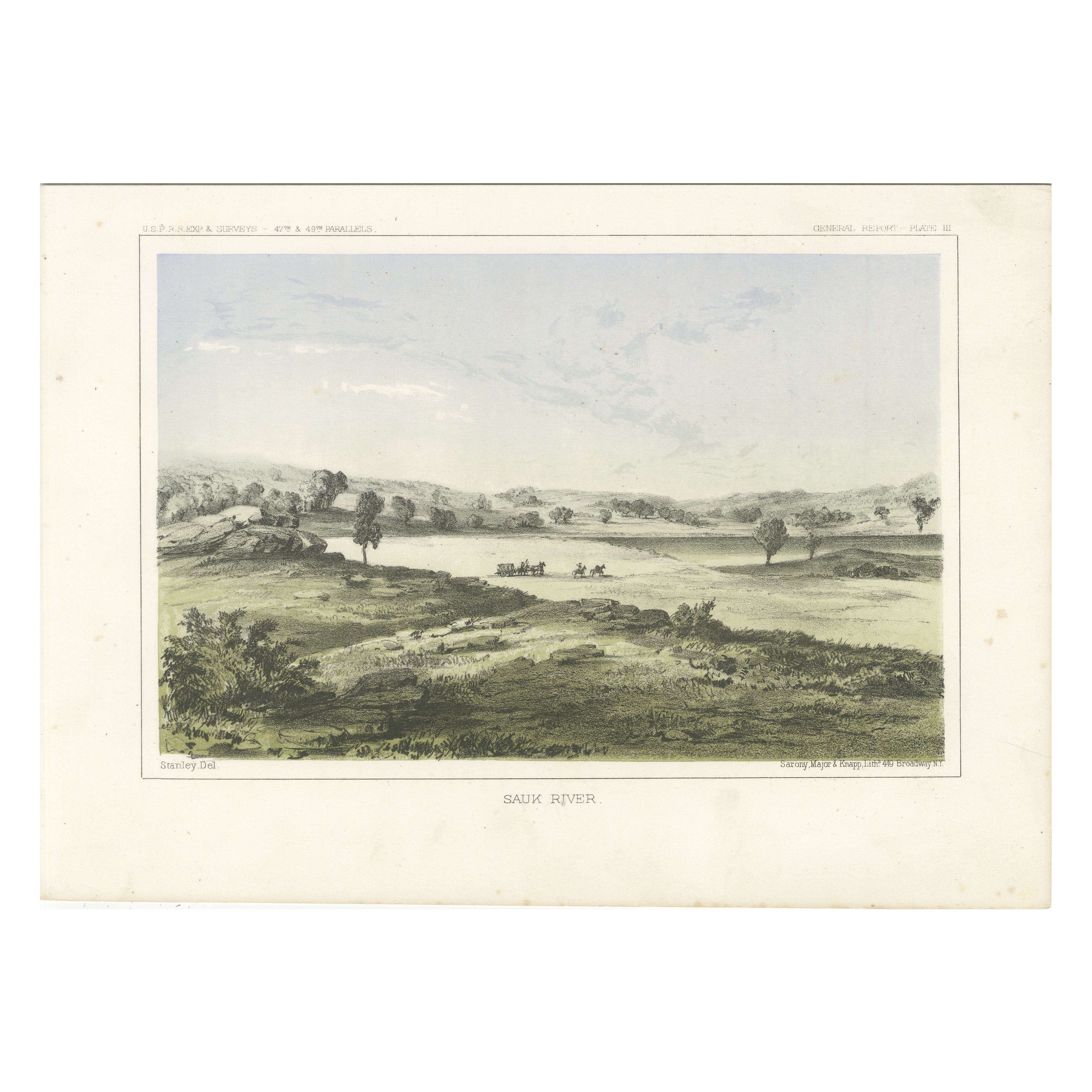
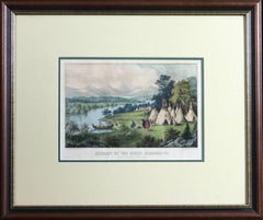
Sauk River Landscape - Tinted Lithograph from the Pacific Railroad Survey, 1856
Located in Langweer, NL
Title: Sauk River Landscape - Tinted Lithograph from the Pacific Railroad Survey, 1856
Description: This serene lithograph, "Sauk River," presents a picturesque view of the lush a...
Category
Antique 1850s Prints
Materials
Paper
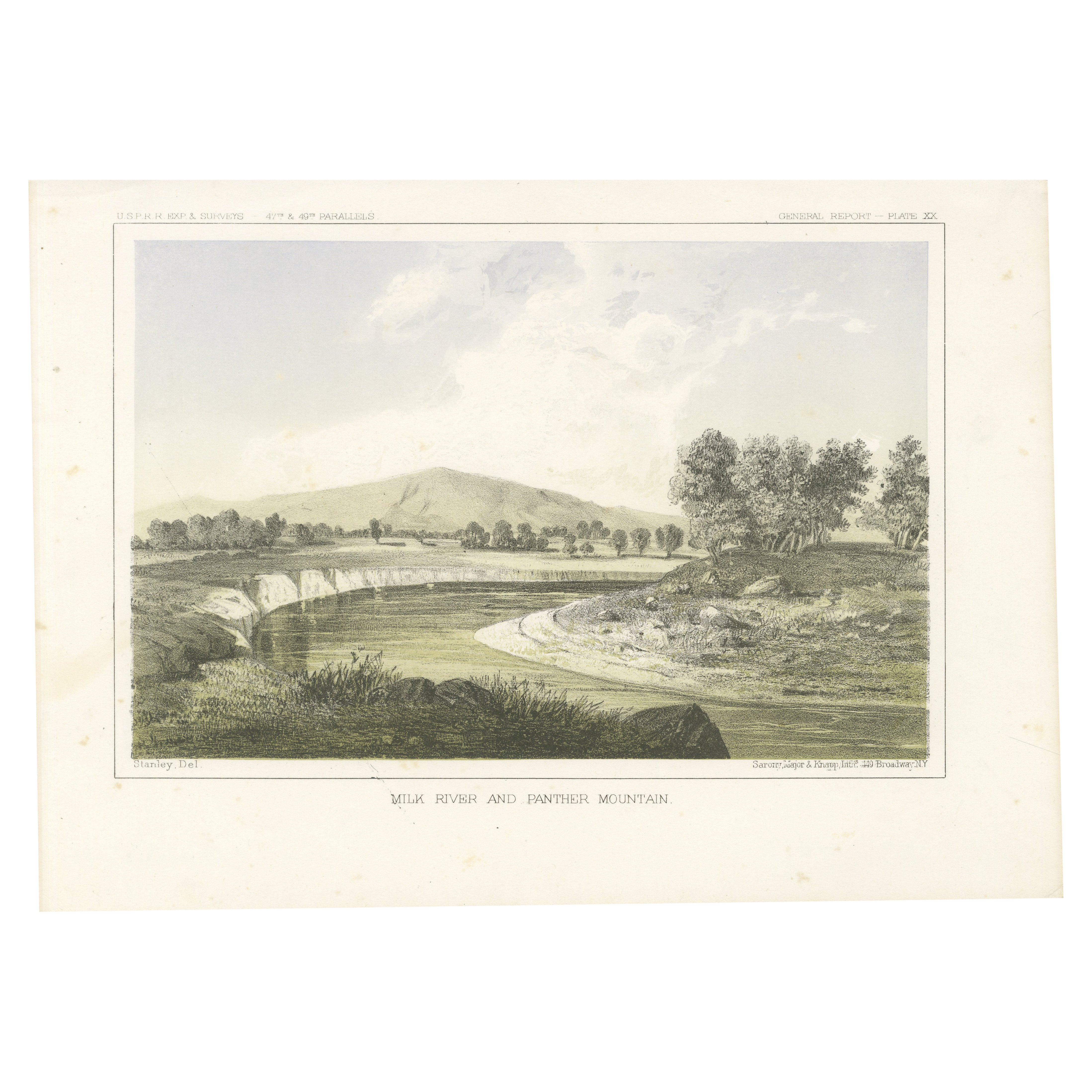
Milk River and Panther Mountain in Montana and Alberta - Tinted Litho, 1856
Located in Langweer, NL
Title: Milk River and Panther Mountain - Tinted Lithograph from the Pacific Railroad Survey, 1856
Description:
This scenic lithograph, "Milk River and Panther Mountain," capture...
Category
Antique 1850s Prints
Materials
Paper
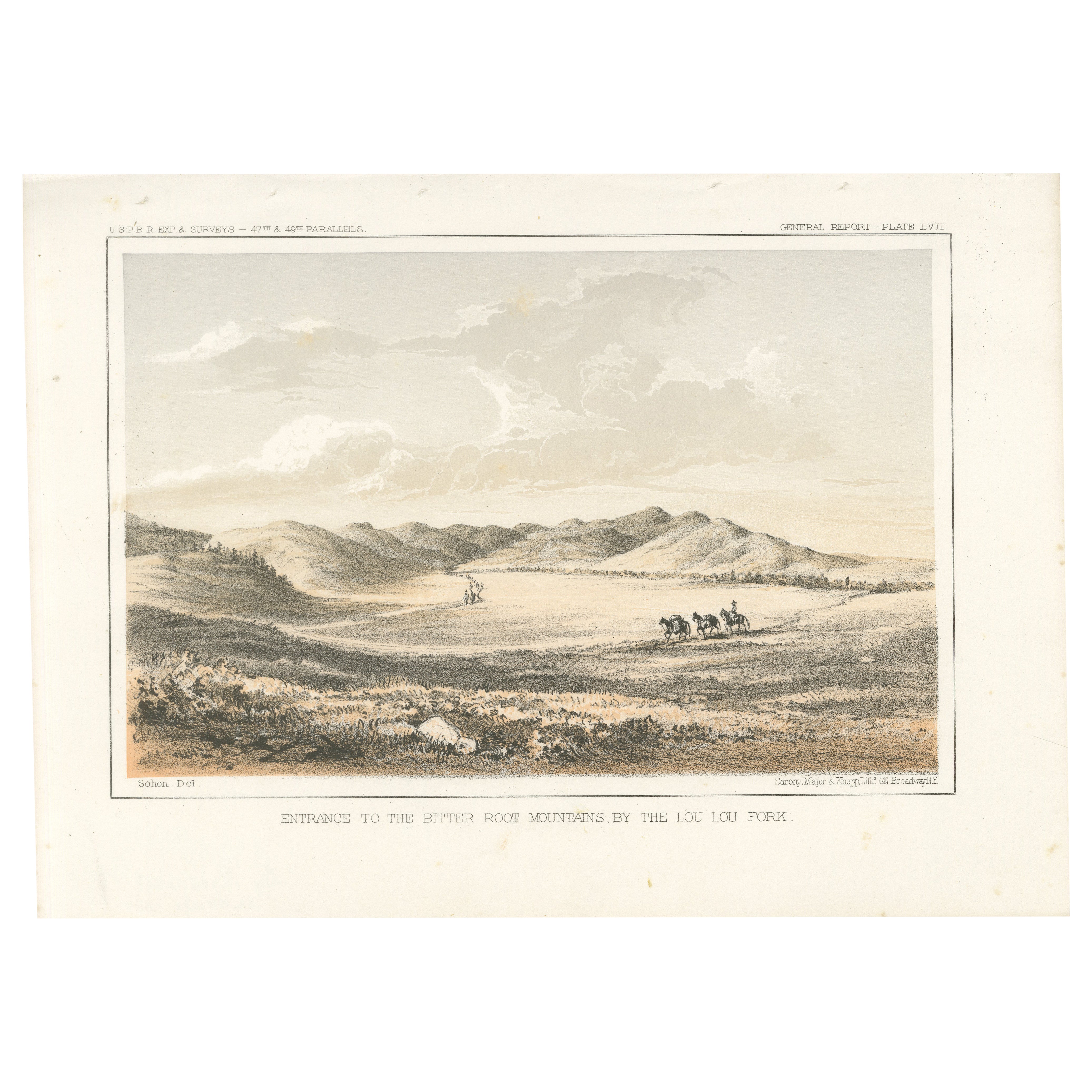
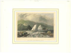
Entrance to the Bitter Root Mountains by the Lou Lou Fork - Lithograph, 1856
Located in Langweer, NL
Title: Entrance to the Bitter Root Mountains by the Lou Lou Fork - Lithograph, 1856
Description: This captivating lithograph, "Entrance to the Bitter Root Mountains by the Lou Lou...
Category
Antique 1850s Prints
Materials
Paper

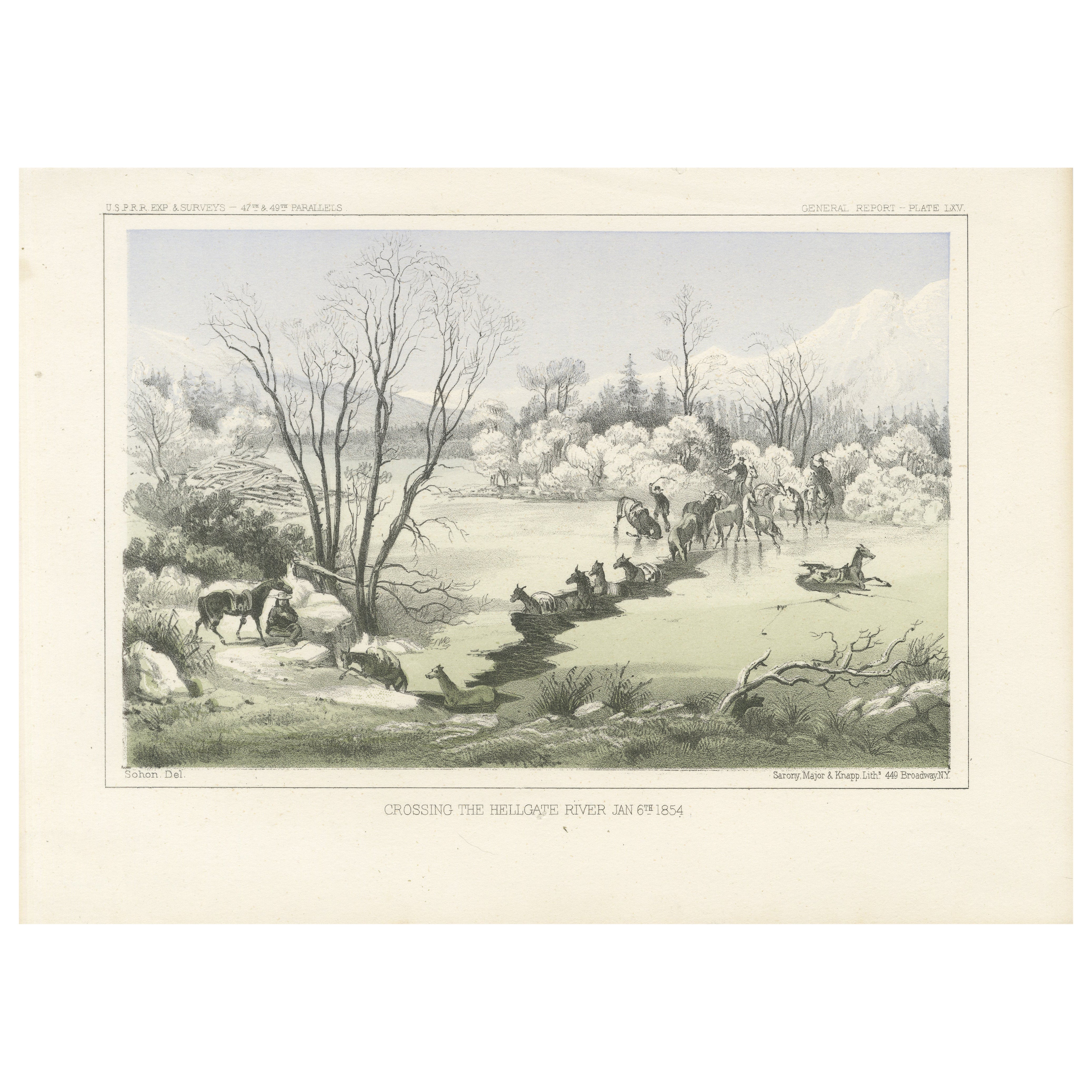
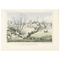
Crossing the Hellgate River in Winter, Montana - Historic 19th-Century Litho
Located in Langweer, NL
Title: Crossing the Hellgate River, January 6th, 1854 - Historic Lithograph
Description: This lithograph, "Crossing the Hellgate River, January 6th, 1854," captures a moment of a...
Category
Antique 1850s Prints
Materials
Paper
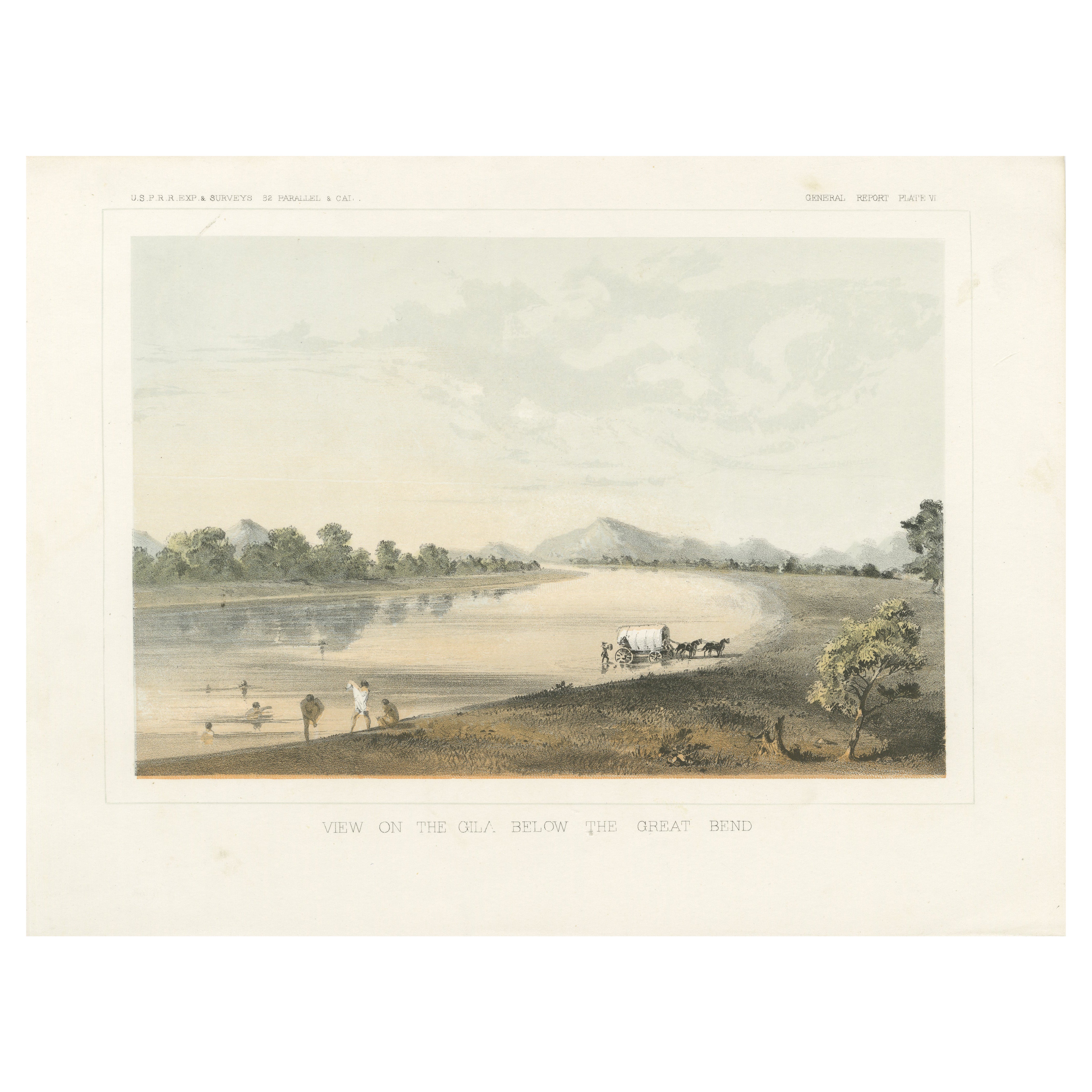
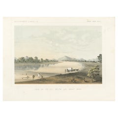
Tinted Lithograph of a View on the Gila Below the Great Bend near Phoenix, 1856
Located in Langweer, NL
Title: Tinted Lithograph of a View on the Gila Below the Great Bend, near Phoenix, Arizona - 1856
Description: This picturesque lithograph, "View on the Gila Below the Great Bend...
Category
Antique 1850s Prints
Materials
Paper
You May Also Like
"Army of the Potomac" by John Bachelder, Civil War Era Lithograph, circa 1863
Located in Colorado Springs, CO
Fully-entitled: Army of the Potomac. The Wagon Trains of the Army of the Potomac en Route from Chickahominy to James River VA. During the Seven...
Category
Antique 19th Century American Prints
Materials
Paper
Trollhättan Falls - Original Lithograph - Mid-19th Century
Located in Roma, IT
Trollhättan Falls is an original modern artwork realized in Germany in the Mid-19th Century.
Original B/W Lithograph on Ivory Paper.
Inscripted on the lower central margin in Capi...
Category
Mid-19th Century Modern Figurative Prints
Materials
Lithograph
'Kettle Falls, Columbia River' original color lithograph by John Mix Stanley
By John Mix Stanley
Located in Milwaukee, WI
In the mid-nineteenth century, the United States government set out to survey and document its newly acquired lands and territories west of the Mississippi. The goals of these surveys were manifold: to produce topographical maps, to document flora and fauna, and to document natural resources to build the emerging US economy. These surveys, and the images from them, also functioned to build the new sense of American identity with the landscape, condensing vistas into the 'picturesque' tradition of European image making. Thus, the entire span of US territory could be seen as a single, cohesive whole.
This lithograph comes from one of six surveys commissioned by the Army's Topographic Bureau in 1853, which sought to find the best route to construct a transcontinental railroad. The result was a thirteen-volume report including maps, lithographs, and technical data entitled 'Explorations and Surveys to ascertain the most practicable and economical route for a Railroad from the Mississippi river to the Pacific Ocean.'
When it came to depicting the Columbia River, as seen in the present print, Stanley chose to depict the river's characteristic rock formations and choppy waters. The figures in the image give the viewer a sense of the vase scale of the imposing landscape. Other explorers that reached the site years before the Pacific Railroad Survey, such as Lewis and Clark, observed this scene with wonder and awe – and it is clear Stanley felt the same way.
5.75 x 8.75 inches, image
6.5 x 9.25 inches, stone
13.25 x 16.25 inches, frame
Artist 'Stanley Del.' lower left
Entitled 'Kettle Falls, Columbia River' lower center margin
Publisher 'Sarony, Major & Knapp. Lith.s 449 Broadway N.Y.' lower right
Inscribed 'U.S.P.R.R. EXP. & SURVEYS — 47th & 49th PARALLELS' upper left
Inscribed 'GENERAL REPORT — PLATE XLVII' upper right
Framed to conservation standards using 100 percent rag matting and Museum Glass to inhibit fading; housed in a brass-surface aluminium moulding.
Print in overall good condition; wrinkles in upper margin and upper right corner; frame in excellent condition.
John Mix Stanley...
Category
1850s Romantic Landscape Prints
Materials
Lithograph
Scenery of the Upper Mississippi Indian Village Currier & Ives lithograph framed
By Currier & Ives
Located in Paonia, CO
Scenery of the Upper Mississippi Indian Village Currier & Ives lithograph is a tranquil scene of an Indian village camped in a meadow next to a be...
Category
Mid-19th Century American Realist Figurative Prints
Materials
Lithograph
Ancient View of Caldwell's Landing - Original Lithograph - 1850a
Located in Roma, IT
Ancient View of Caldwell's Landing is an original modern artwork realized in Italy in the first half of the 19th Century.
Original Lithograph on Ivory Paper.
Inscripted in capital...
Category
1850s Modern Figurative Prints
Materials
Lithograph
'Camp Red River Hunters' original lithograph by John Mix Stanley
By John Mix Stanley
Located in Milwaukee, WI
In the mid-nineteenth century, the United States government set out to survey and document its newly acquired lands and territories west of the Mississippi. The goals of these surveys were manifold: to produce topographical maps, to document flora and fauna, and to document natural resources to build the emerging US economy. These surveys, and the images from them, also functioned to build the new sense of American identity with the landscape, condensing vistas into the 'picturesque' tradition of European image making. Thus, the entire span of US territory could be seen as a single, cohesive whole.
This lithograph comes from one of six surveys commissioned by the Army's Topographic Bureau in 1853, which sought to find the best route to construct a transcontinental railroad. The result was a thirteen-volume report including maps, lithographs, and technical data entitled 'Explorations and Surveys to ascertain the most practicable and economical route for a Railroad from the Mississippi river to the Pacific Ocean.' In particular, the print comes from the northern survey, commanded by Isaac Stevens, which explored the regions between the 47th and 49th parallels.
In this image, Stanley shows an encampment of the people known as the Red River of the North hunters. They were generations of European and mixed-race trappers who lived on the frontier and had Indian wives and mixed-race children. They had come to the area for bison hunting, as the herds were still vast on the prairies. In the image, the figures and their encampment are dwarfed by the vast landscape around them, indicating the sublimity of these new American territories.
5.75 x 8.75 inches, image
6.5 x 9.25 inches, stone
17 x 20 inches, frame
Artist 'Stanley Del.' lower left
Entitled 'Camp Red River Hunters' lower center margin
Publisher 'Sarony, Major & Knapp. Lith.s 449 Broadway N.Y.' lower right
Inscribed 'U.S.P.R.R. EXP. & SURVEYS — 47th & 49th PARALLELS' upper left
Inscribed 'GENERAL REPORT — PLATE XII' upper right
Framed to conservation standards using 100 percent rag matting with French accents; glazed with UV5 Plexiglas to inhibit fading; housed in a gold reverse ogee moulding.
Print in overall good condition; some localized foxing and discoloration; minor surface abrasions to frame.
John Mix Stanley...
Category
1850s Romantic Landscape Prints
Materials
Lithograph
More Ways To Browse
Green River Furniture
Montana Sapphire
Rape Of The Sabine
Record Player Cabinet
Rectangular Gallery Tray
Regency Style Bed Frame And Headboard
Retro Hawaiian Rattan Furniture
Rococo Teapot
Roman Stone Fragment
Rope Trimed Table
Rose Ginger Jar
Rosewood Chiffonier
Rosewood Writing Slope
Sabino Opalescent Glass
Sabino Opalescent
Sage Green Cabinet
Sculptures Of Fist
Seguso Fish