Items Similar to Geological Map of North America by A.K. Johnston – Mountains and Valleys 1852


Want more images or videos?
Request additional images or videos from the seller
1 of 12
Geological Map of North America by A.K. Johnston – Mountains and Valleys 1852
$306.62per item
£229.51per item
€260per item
CA$422per item
A$470.36per item
CHF 246.78per item
MX$5,743.85per item
NOK 3,124.79per item
SEK 2,953.40per item
DKK 1,979.30per item
Quantity
About the Item
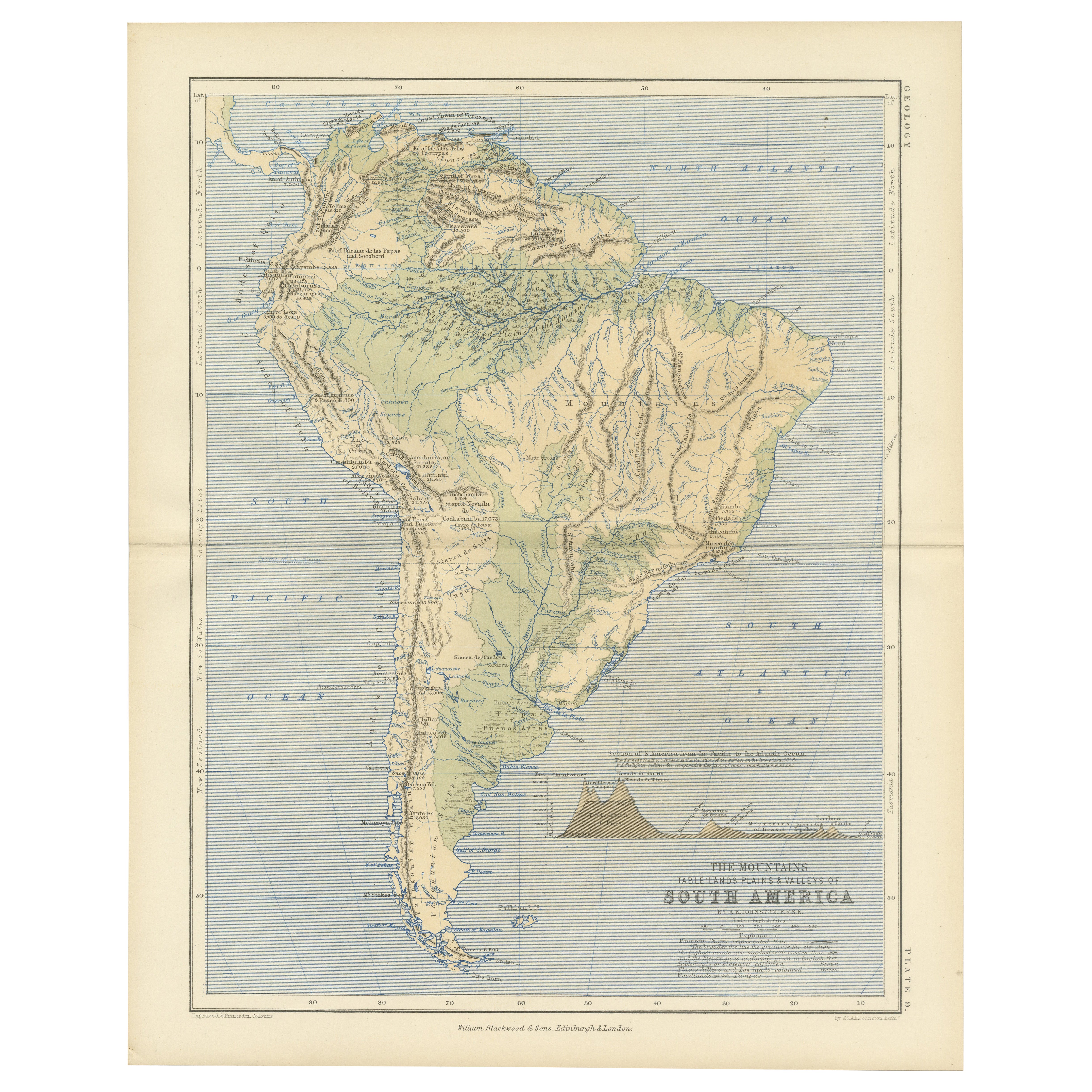
Geological Map of North America by A.K. Johnston – Mountains and Valleys 1852
This finely detailed and beautifully shaded antique map titled "The Mountains, Table Lands, Plains & Valleys of North America" was created by the noted Scottish geographer Alexander Keith Johnston and published in 1852 by William Blackwood & Sons in Edinburgh and London. It was issued as Plate 8 in Johnston’s groundbreaking *Physical Atlas of Natural Phenomena*, one of the earliest and most influential works of thematic cartography in the 19th century.
The map presents the topographic structure of the North American continent, emphasizing physical geography over political borders. Using a delicate yet effective palette of hand-applied color, it distinguishes between mountainous regions, plateaus, plains, and river valleys. Green areas denote lowlands and river basins, while tan and brown areas indicate elevated terrain, such as mountain ranges and high plateaus.
Key geographical features are precisely labeled, including the Rocky Mountains, Appalachian Mountains, Sierra Nevada, Great Basin, Canadian Shield, and Mississippi River Valley. The map covers all of North America, including Canada, the United States, Mexico, Central America, the Caribbean, and Greenland, as well as the Arctic archipelagos. Major tablelands such as those of Mexico and the Colorado Plateau are also clearly outlined, demonstrating the complexity of North America's geological structure.
What sets this map apart is its educational clarity and scientific intent. Johnston’s work was intended to inform and enlighten readers about the structure of the natural world, making this a valuable piece not just for collectors of antique maps but also for educators, environmental historians, and interior designers seeking historically meaningful artwork.
Alexander Keith Johnston (1804–1871) was a pioneering figure in British cartography. As Geographer in Ordinary to Queen Victoria for Scotland, he advanced the visual communication of scientific data through maps. His *Physical Atlas* remains a landmark publication in the history of science and cartography.
Condition and framing tips:
Very good condition with light age toning, original centerfold, and faint foxing at edges. Printed area clean and well-preserved. Frame in dark wood or black with a soft ivory or sage green mat to enhance the earthy palette and highlight the map's elegant detailing. Perfect for libraries, offices, or natural history-themed interiors.
- Dimensions:Height: 13.59 in (34.5 cm)Width: 10.79 in (27.4 cm)Depth: 0.01 in (0.2 mm)
- Materials and Techniques:
- Place of Origin:
- Period:
- Date of Manufacture:1852
- Condition:Very good condition. Light overall toning near the margins. The paper remains strong and well-preserved. Folding line as issued.
- Seller Location:Langweer, NL
- Reference Number:Seller: BG-13207-81stDibs: LU3054345386722
About the Seller
5.0
Recognized Seller
These prestigious sellers are industry leaders and represent the highest echelon for item quality and design.
Platinum Seller
Premium sellers with a 4.7+ rating and 24-hour response times
Established in 2009
1stDibs seller since 2017
2,513 sales on 1stDibs
Typical response time: <1 hour
- ShippingRetrieving quote...Shipping from: Langweer, Netherlands
- Return Policy
Authenticity Guarantee
In the unlikely event there’s an issue with an item’s authenticity, contact us within 1 year for a full refund. DetailsMoney-Back Guarantee
If your item is not as described, is damaged in transit, or does not arrive, contact us within 7 days for a full refund. Details24-Hour Cancellation
You have a 24-hour grace period in which to reconsider your purchase, with no questions asked.Vetted Professional Sellers
Our world-class sellers must adhere to strict standards for service and quality, maintaining the integrity of our listings.Price-Match Guarantee
If you find that a seller listed the same item for a lower price elsewhere, we’ll match it.Trusted Global Delivery
Our best-in-class carrier network provides specialized shipping options worldwide, including custom delivery.More From This Seller
View AllGeological Map of South America by A.K. Johnston – Mountains and Valleys 1852
Located in Langweer, NL
Geological Map of South America by A.K. Johnston – Mountains and Valleys 1852
This antique map titled "The Mountains, Table Lands, Plains & Valleys of South America" was produced by...
Category
Antique Mid-19th Century Scottish Prints
Materials
Paper
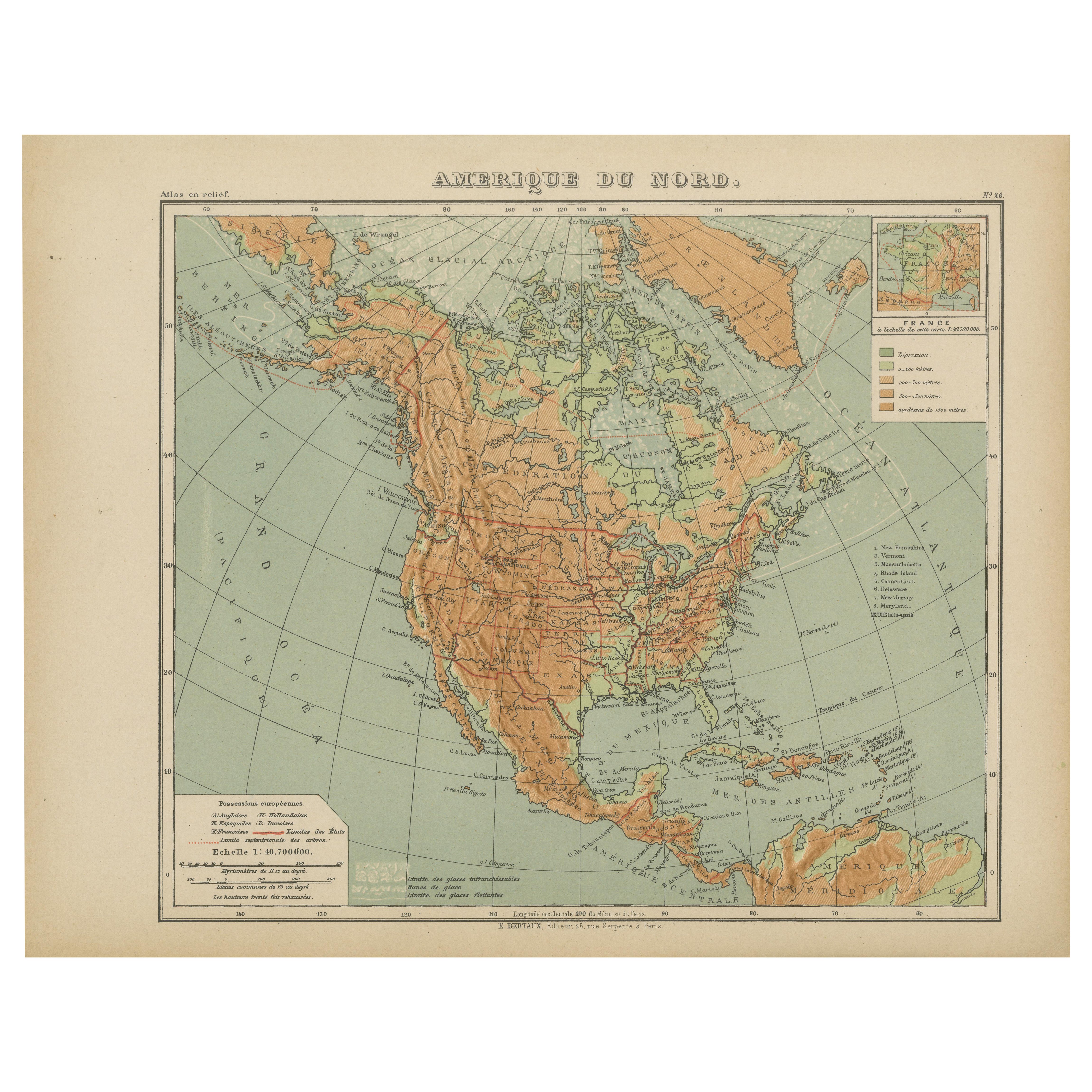
Antique Map of North America – Physical Relief Map by Hachette c.1883
Located in Langweer, NL
Antique Map of North America – Physical Relief Map by Hachette c.1883
Description:
This antique map titled “Amérique du Nord” was published around 1883 by E. Hachette in Paris as pa...
Category
Antique Late 19th Century French Maps
Materials
Paper
Antique Map of North America by A & C. Black, 1870
Located in Langweer, NL
Antique map titled 'North America'. Original antique map of North America. This map originates from ‘Black's General Atlas of The World’. Published by A & C. Black, 1870.
Category
Antique Late 19th Century Maps
Materials
Paper

$259 Sale Price
20% Off
Antique Map of North America by Johnston, 1882
By Alexander Keith Johnston
Located in Langweer, NL
Antique map titled 'North America'.
Old map of North America. This map originates from 'The Royal Atlas of Modern Geography, Exhibiting, in a Series of Entirely Original and Authen...
Category
Antique 19th Century Maps
Materials
Paper

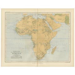
Geological Map of Africa by A.K. Johnston – Mountains and Valleys 1852
Located in Langweer, NL
Geological Map of Africa by A.K. Johnston – Mountains and Valleys 1852
This antique map titled "The Mountains, Table Lands, Plains & Valleys of Africa" was produced by the distingui...
Category
Antique Mid-19th Century Scottish Prints
Materials
Paper
Antique Map of North America, 1821
Located in Langweer, NL
Antique map of America titled 'Carte de l'Amerique septentrionale'. Scarce map of North America, shortly after the Louisiana Purchase and the first ...
Category
Antique 19th Century Maps
Materials
Paper

$613 Sale Price
20% Off
You May Also Like
North America. Century Atlas antique vintage map
Located in Melbourne, Victoria
'The Century Atlas. North America'
Original antique map, 1903.
Central fold as issued. Map name and number printed on the reverse corners.
Sheet 40cm by 29.5cm.
Category
Early 20th Century Victorian More Prints
Materials
Lithograph

Original Antique Map of North America by Dower, circa 1835
Located in St Annes, Lancashire
Nice map of North America
Drawn and engraved by J.Dower
Published by Orr & Smith. C.1835
Unframed.
Free shipping
Category
Antique 1830s English Maps
Materials
Paper

Large Original Vintage Map of North America, circa 1920
Located in St Annes, Lancashire
Great map of North America
Original color. Good condition
Published by Alexander Gross
Unframed.
Category
Vintage 1920s English Edwardian Maps
Materials
Paper

1864 Map of North America, Antique Hand-Colored Map, by Adolphe Hippolyte Dufour
Located in Colorado Springs, CO
Offered is a map of North America entitled Amerique du Nord from 1864. This rare, separately published wall map was produced by Adolphe Hippolyte Dufour. This map includes vibrant an...
Category
Antique 1860s French Maps
Materials
Paper

Original Antique Map of The United States of America by Dower, circa 1835
Located in St Annes, Lancashire
Nice map of the USA
Drawn and engraved by J.Dower
Published by Orr & Smith. C.1835
Unframed.
Free shipping
Category
Antique 1830s English Maps
Materials
Paper

1846 "North America" Map, Engraved by I. Dower
Located in Colorado Springs, CO
Presented is an original 1846 map of “North America.” The map was drawn and engraved by I. Dower and published in London by Orr & Company. The map depicts North America, to include G...
Category
Antique 1840s English Victorian Maps
Materials
Paper

More Ways To Browse
Library Table American
Antique Blackwood Table
French Herbarium
French Kitchen Hutch
French Regency Bed
French Tea Trolley
Frog Wood Sculpture
George Iii Dressing Table
Georgian Style China Cabinet
Ginger Jar Blossom
Glass Music Box
Golden Closet
Greek Key Tray
Grotto Wall
Gun Storage
Gustavian Tall Cabinet
Half Round Window
Hand Carved Elephant Head