Items Similar to Hand-Colored Steel Engraving of Batavia 'Jakarta', Indonesia, Ca.1840

Want more images or videos?
Request additional images or videos from the seller
1 of 5
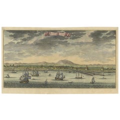
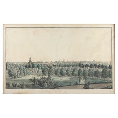
Hand-Colored Steel Engraving of Batavia 'Jakarta', Indonesia, Ca.1840
$141.77
$177.2220% Off
£106.27
£132.8420% Off
€120
€15020% Off
CA$194.77
CA$243.4720% Off
A$217.45
A$271.8120% Off
CHF 113.94
CHF 142.4220% Off
MX$2,661.76
MX$3,327.2020% Off
NOK 1,447.02
NOK 1,808.7820% Off
SEK 1,364.36
SEK 1,705.4520% Off
DKK 913.48
DKK 1,141.8520% Off
Shipping
Retrieving quote...The 1stDibs Promise:
Authenticity Guarantee,
Money-Back Guarantee,
24-Hour Cancellation
About the Item
Antique print titled 'Batavia'.
Steel engraving of Batavia (Jakarta), Indonesia. Originates from 'Meyers Universum'.
Artists and Engravers: Joseph Meyer (May 9, 1796 - June 27, 1856) was a German industrialist and publisher, most noted for his encyclopedia, Meyers Konversations-Lexikon. Meyer operated very successfully as a publisher, employing a system of serial subscription to publications, which was new at that time. To this end he founded a company, Bibliographisches Institut, in Gotha in 1826. It published several editions of the Bible, works of classical literature ("Miniatur-Bibliothek der deutschen Classiker", "Groschen-Bibliothek"), atlases, the world in pictures on steel engravings ("Meyers Universum", 1833–61, 17 volumes in 12 languages with 80,000 subscribers all over Europe), and an encyclopaedia.
Condition:
Good, age-related toning. Minor wear, blank verso. Please study image carefully.
- Dimensions:Height: 5.91 in (15 cm)Width: 8.47 in (21.5 cm)Depth: 0 in (0.02 mm)
- Materials and Techniques:
- Period:
- Date of Manufacture:circa 1840
- Condition:Wear consistent with age and use. Condition: Good, age-related toning. Minor wear, blank verso. Please study image carefully.
- Seller Location:Langweer, NL
- Reference Number:Seller: BG-101351stDibs: LU3054326761942
About the Seller
5.0
Recognized Seller
These prestigious sellers are industry leaders and represent the highest echelon for item quality and design.
Platinum Seller
Premium sellers with a 4.7+ rating and 24-hour response times
Established in 2009
1stDibs seller since 2017
2,511 sales on 1stDibs
Typical response time: <1 hour
- ShippingRetrieving quote...Shipping from: Langweer, Netherlands
- Return Policy
Authenticity Guarantee
In the unlikely event there’s an issue with an item’s authenticity, contact us within 1 year for a full refund. DetailsMoney-Back Guarantee
If your item is not as described, is damaged in transit, or does not arrive, contact us within 7 days for a full refund. Details24-Hour Cancellation
You have a 24-hour grace period in which to reconsider your purchase, with no questions asked.Vetted Professional Sellers
Our world-class sellers must adhere to strict standards for service and quality, maintaining the integrity of our listings.Price-Match Guarantee
If you find that a seller listed the same item for a lower price elsewhere, we’ll match it.Trusted Global Delivery
Our best-in-class carrier network provides specialized shipping options worldwide, including custom delivery.More From This Seller
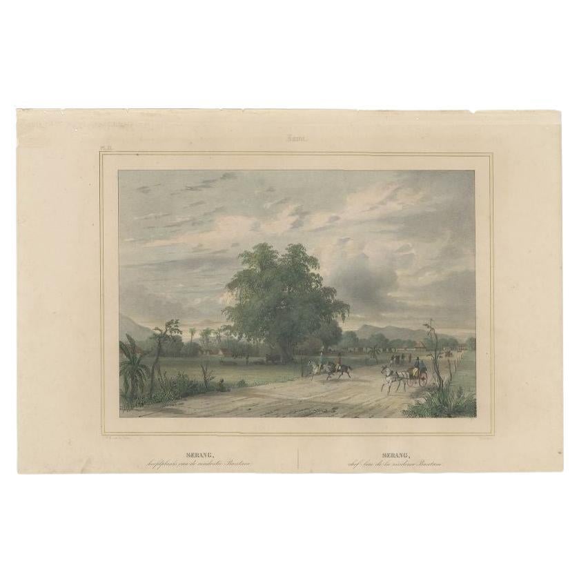
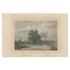
View AllAntique Print of Serang, Java in Indonesia, circa 1844
Located in Langweer, NL
Antique print titled 'Serang - Serang'. Old print with a view Serang, Banten province (Bantam). Originates from 'Gezigten uit Neerlands Indie, naar de natuur geteekend en beschreven'...
Category
Antique 19th Century Prints
Materials
Paper
$274 Sale Price
20% Off
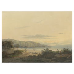
Original Antique Chromolithograh of Srigonjo Bay, the South Coast of Java, 1872
Located in Langweer, NL
View of Srigonjo Bay on the south coast of Java (Indonesia)
Original title in Dutch: "De baai Srigonjo aan de zuidkust van Java"
One of a serie of twenty-four chromolithographs, fi...
Category
Antique 1870s Prints
Materials
Paper
$1,949 Sale Price
40% Off
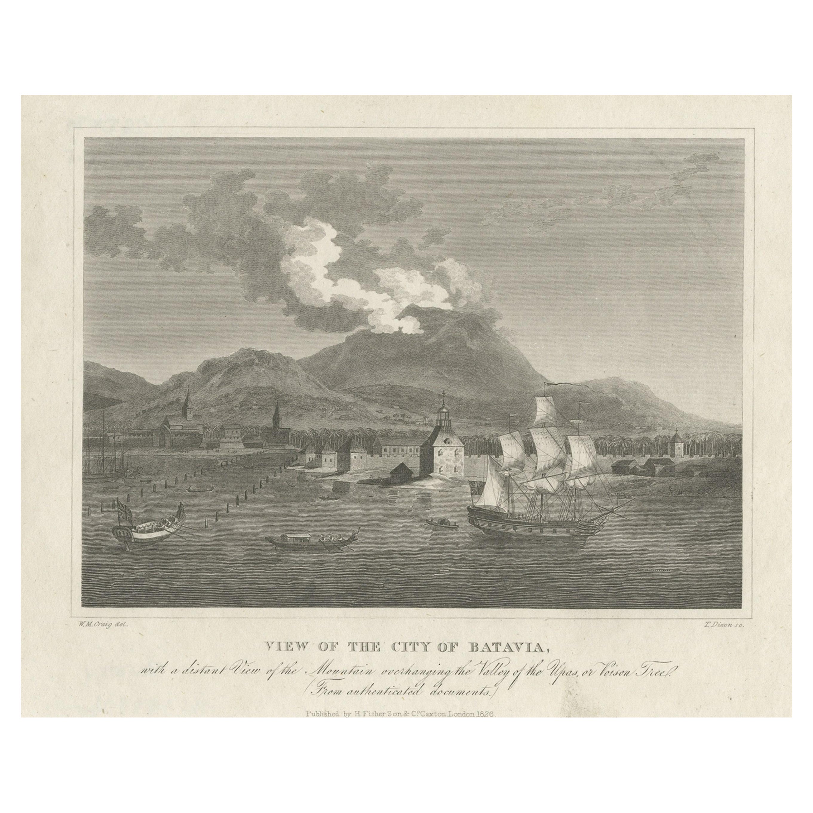
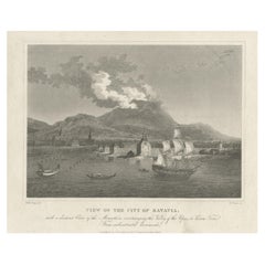
Antique Print of the Harbour Sunda Kelapa of Batavia in the Dutch Indies, 1826
Located in Langweer, NL
Description: Antique print titled 'View of the City of Batavia'. Old print with a view of the city of Batavia (Jakarta), Indonesia.
In the background Genung Salak or Salak Mounta...
Category
Antique 1820s Prints
Materials
Paper
$425 Sale Price
20% Off
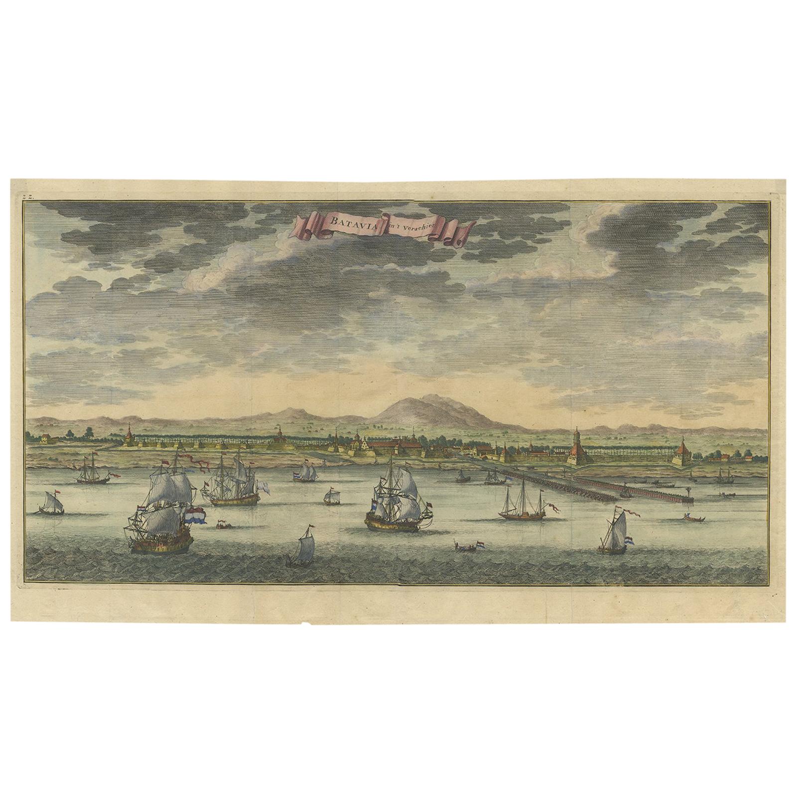
Antique Print of Batavia or Nowadays Jakarta, Indonesia, by Valentijn (1726)
By F. Valentijn
Located in Langweer, NL
Antique print Indonesia titled 'Batavia in 't Verschiet'. Large panoramic view on Batavia, present day Jakarta, Indonesia. Originates from 'Oud en Nieuw Oost-Indiën (..)' by François...
Category
Antique Mid-18th Century Prints
Materials
Paper
$897 Sale Price
20% Off
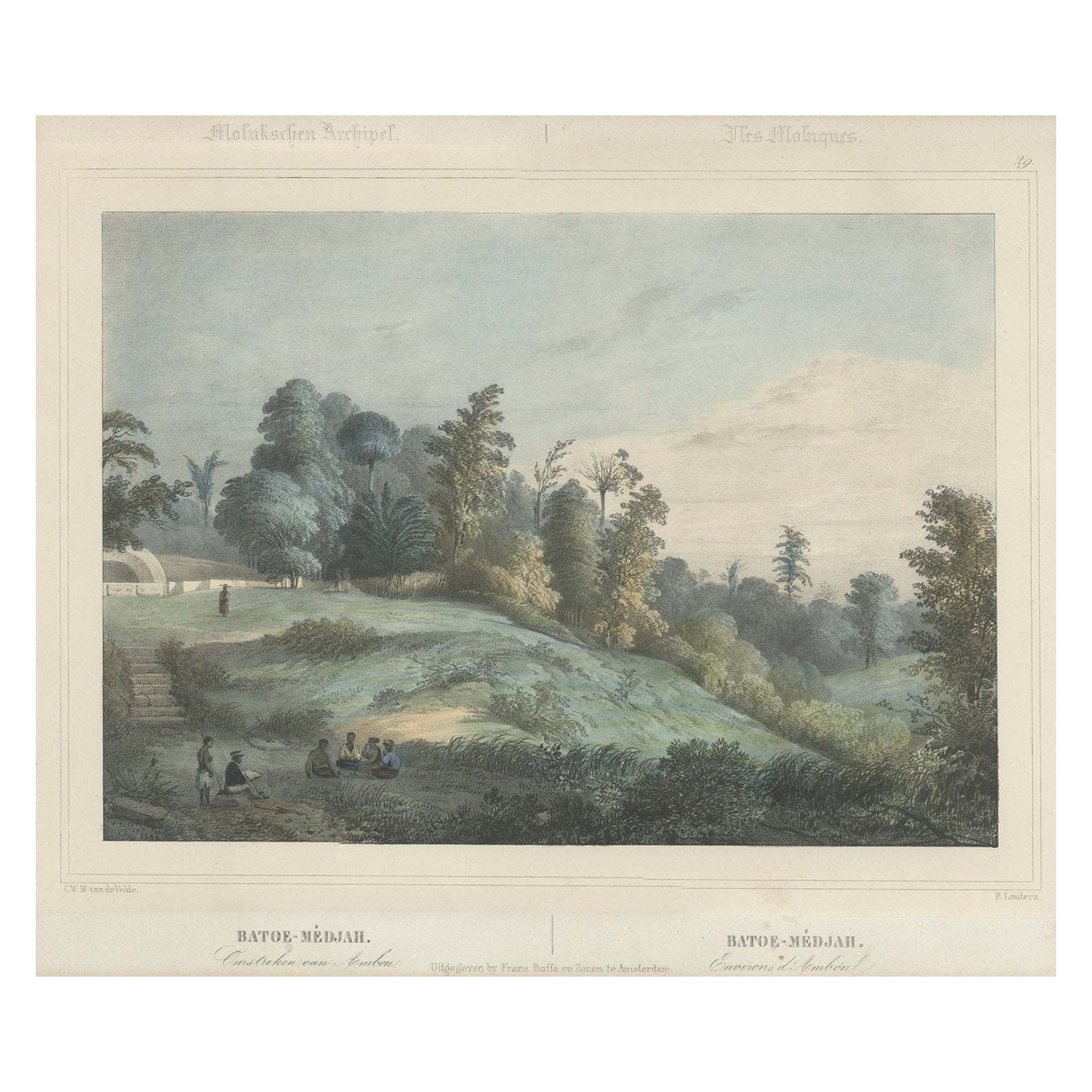
Antique Print of Batu Meja in the Moluccas, Indonesia, c.1845
Located in Langweer, NL
Antique print titled 'Batoe-Médjah - Batoe-Médjah'. Lithograph on chine collé with a view of Batu Meja in the district of Sirimau, Amboine, Maluku, Indonesia. Originates from 'Gezigt...
Category
Antique 19th Century Prints
Materials
Paper

$245 Sale Price
20% Off
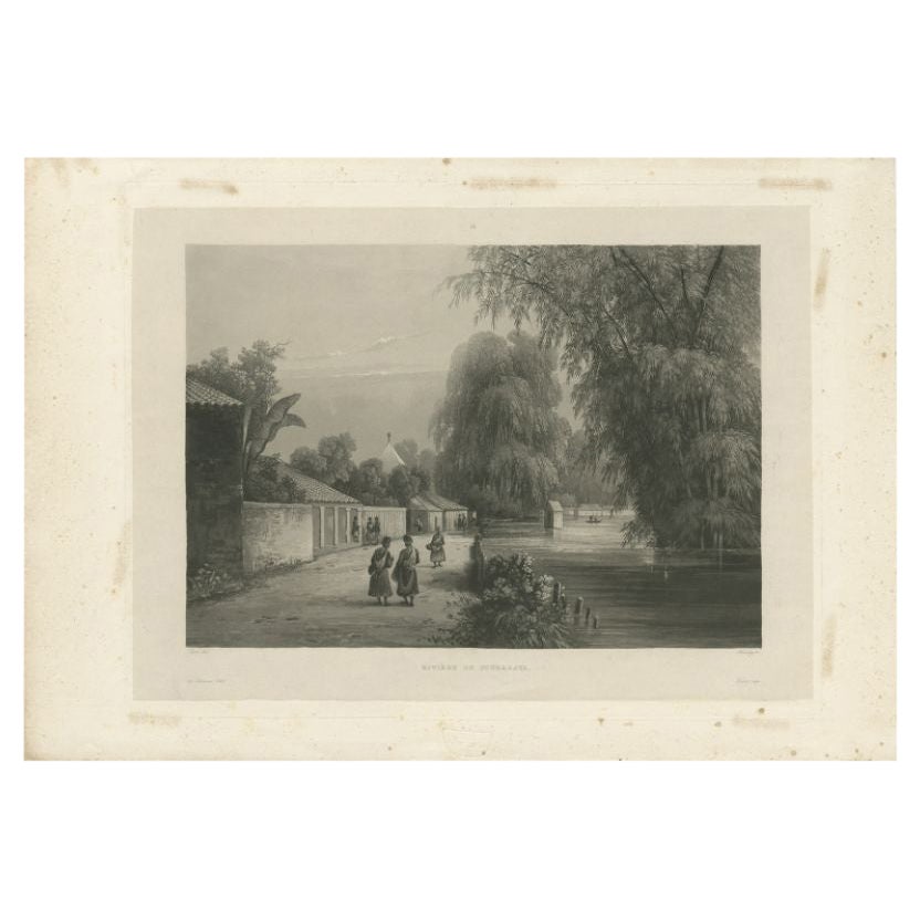
Antique Print of the Surabaya River, Java Island, in Indonesia, 1835
Located in Langweer, NL
Antique print titled 'Rivière de Sourabaya'. Chine-collé aquatint of the Surabaya (or Soerabaja) river, Indonesia. Originates from the series 'Voyage autour du monde par les mers de ...
Category
Antique 19th Century Prints
Materials
Paper

$340 Sale Price
20% Off
You May Also Like
Ancient View of Batavia - Original Lithograph - Half of the 19th Century
Located in Roma, IT
Ancient View of Batavia is an original modern artwork realized in the first half of the 19th Century.
Original B/W Lithograph on Ivory Paper.
Inscripted on the lower margin in Ca...
Category
Early 19th Century Modern Landscape Prints
Materials
Lithograph
Ancient View of Calcutta - Original Lithograph - Half of the 19th Century
Located in Roma, IT
Calcutta is an original modern artwork realized in the first half of the 19th Century.
Original B/W Lithograph on Ivory Paper.
Inscripted on the lower margin in Capital Letters: ...
Category
Early 19th Century Modern Landscape Prints
Materials
Lithograph
Ancient View of Bombay - Original Lithograph - Half of the 19th Century
Located in Roma, IT
Ancient View of Bombay is an original modern artwork realized in the first half of the 19th Century.
Original B/W Lithograph on Ivory Paper.
Inscripted on the lower margin in Cap...
Category
Early 19th Century Modern Landscape Prints
Materials
Lithograph

Original Antique Print of New York City. Dated 1837
Located in St Annes, Lancashire
Great print of New York City
Steel engraving after W.H Bartlett
Published by Virtue 1837
Unframed.
The measurement is the paper size.
Free shipping
Category
Antique 1830s English Other Prints
Materials
Paper
Hand Colored Copperplate Engraving of Copenhagen, Denmark
Located in Kastrup, DK
Hand-colored copperplate engraving depicting an interesting old view of Copenhagen seen from Frederiksberg Castle Gardens, approximate. 1790-1800.
Framed in a mahogany frame from sam...
Category
Antique Late 18th Century Danish Louis XVI Prints
Materials
Glass, Mahogany, Paper
Italian Hand Colored Engraving, A View of the Great Arsenal at Venice, May 1794
Located in Atlanta, GA
in addition to the aforementioned title the engraving reads, "which has two gates, one for the workmen to enter at, one for the ships", "Published according to Act of Parliament...
Category
Antique 1790s Italian Neoclassical Prints
Materials
Paper
More Ways To Browse
Antique Plow
Antique Salt Bowls
Antique Shamrock
Antique Spring Scale
Antique Street Clock
Antique Thai Buddha Statue
Antique Trough Fountains
Antique Water Kettle
Antique Wood Santos Santo
Art Nouveau Room Divider
Art Nouveau Sugar Bowl
Barbara Barry For Baker
Beetle Model
Blue Swedish Chest
Bone Inlay Dresser
Brass Couple Sculpture
Bruksbo Rosewood
Car Wall Sculpture