Items Similar to Hand-Colored View of Edinburgh, Italy, c.1700 – “Edenburgo Metropoli”


Want more images or videos?
Request additional images or videos from the seller
1 of 12
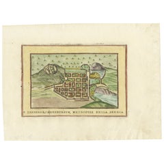
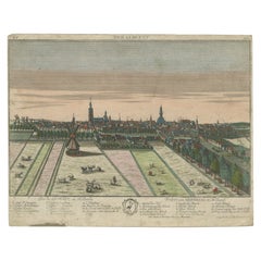
Hand-Colored View of Edinburgh, Italy, c.1700 – “Edenburgo Metropoli”
$527.18
£392.38
€440
CA$722.11
A$803.14
CHF 419.38
MX$9,773.40
NOK 5,356.08
SEK 5,023.05
DKK 3,349.57
Shipping
Retrieving quote...The 1stDibs Promise:
Authenticity Guarantee,
Money-Back Guarantee,
24-Hour Cancellation
About the Item
Hand-Colored View of Edinburgh, Italy, c.1700 – “Edenburgo Metropoli”
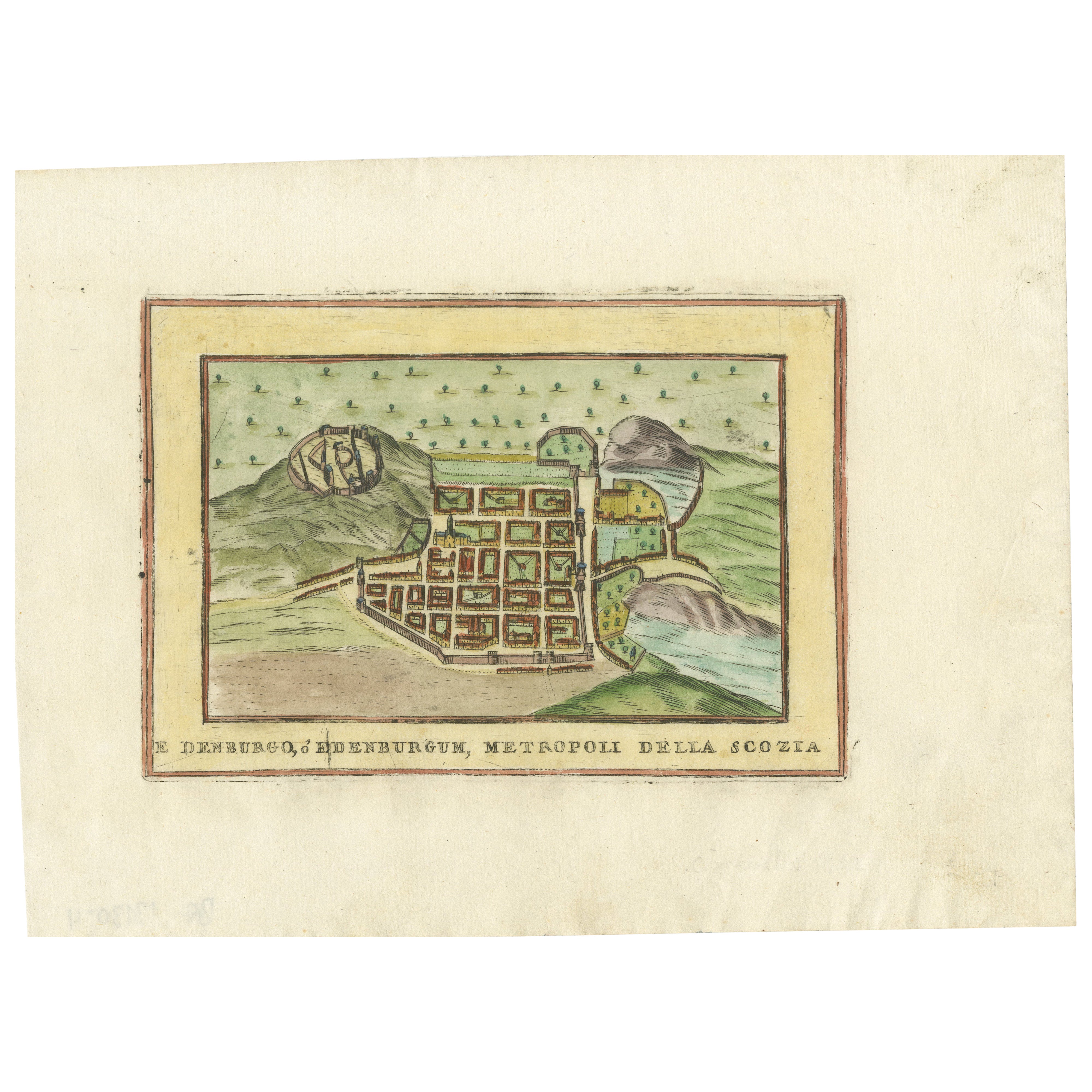
This finely hand-colored engraving shows a panoramic view of Edinburgh, titled in Italian “Edenburgo Metropoli della Scozia”, translating to “Edinburgh, Metropolis of Scotland.” The city is depicted with remarkable clarity, featuring its prominent castle, clustered buildings, and surrounding hills and plains. The composition is framed by a decorative border and crowned with the Edinburgh coat of arms, emphasizing its status as the capital of Scotland.
The print is characteristic of Italian city views produced in the late 17th to early 18th century. Its style, coloring, and layout suggest it is likely from the series published by Pietro Bertelli (active late 16th – early 17th century) or his successors such as Giuseppe Rosaccio, both known for similar engravings of European cities with Italian titles. However, given the hand coloring and paper type, another possibility is the later Italian publishers of the early 1700s who reproduced earlier Bertelli plates for the market of armchair travellers and collectors.
This type of city view served both decorative and educational purposes, presenting the grandeur and strategic location of major cities to European audiences. Edinburgh here is shown from an elevated perspective, revealing the castle rock, the old town's dense urban layout, and surrounding landscapes with distant hills and waters, likely indicating the Firth of Forth.
Such engravings are increasingly sought after by collectors of antique maps, city views, and Grand Tour memorabilia. They make impactful interior pieces for homes, offices, or libraries, especially when displayed alongside other European city views from the same era.
Condition Report:
Overall good condition. Strong hand coloring with fresh tones. Light general age toning and minor foxing in the margins, typical for 18th-century paper. Some faint handling marks and slight edge wear, not affecting the printed area. No tears or repairs visible. Sheet retains wide margins, ideal for framing.
Framing Tip:
To enhance its historic character, consider framing with an antique gold leaf or dark wood frame and a neutral archival mat with a thin gold inner border. UV-protective glass is recommended to preserve the vibrant hand coloring.
- Dimensions:Height: 7.92 in (20.1 cm)Width: 10.99 in (27.9 cm)Depth: 0.01 in (0.2 mm)
- Materials and Techniques:Paper,Engraved
- Place of Origin:
- Period:
- Date of Manufacture:circa 1700
- Condition:Overall good condition. Strong hand coloring with fresh tones. Light general age toning and minor foxing in the margins, typical for 18th-century paper.
- Seller Location:Langweer, NL
- Reference Number:Seller: BG-13130-31stDibs: LU3054345715652
About the Seller
5.0
Recognized Seller
These prestigious sellers are industry leaders and represent the highest echelon for item quality and design.
Platinum Seller
Premium sellers with a 4.7+ rating and 24-hour response times
Established in 2009
1stDibs seller since 2017
2,502 sales on 1stDibs
Typical response time: <1 hour
- ShippingRetrieving quote...Shipping from: Langweer, Netherlands
- Return Policy
Authenticity Guarantee
In the unlikely event there’s an issue with an item’s authenticity, contact us within 1 year for a full refund. DetailsMoney-Back Guarantee
If your item is not as described, is damaged in transit, or does not arrive, contact us within 7 days for a full refund. Details24-Hour Cancellation
You have a 24-hour grace period in which to reconsider your purchase, with no questions asked.Vetted Professional Sellers
Our world-class sellers must adhere to strict standards for service and quality, maintaining the integrity of our listings.Price-Match Guarantee
If you find that a seller listed the same item for a lower price elsewhere, we’ll match it.Trusted Global Delivery
Our best-in-class carrier network provides specialized shipping options worldwide, including custom delivery.More From This Seller
View AllEdinburgh City Plan, Italy c.1700 – “Edenburgo Metropoli della Scozia”
Located in Langweer, NL
Edinburgh City Plan, Italy c.1700 – “Edenburgo Metropoli della Scozia”
This is a charming hand-colored engraved plan of Edinburgh, titled in Italian Edenburgo, Metropoli della Scozi...
Category
Antique Early 18th Century Italian Prints
Materials
Paper
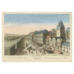
Hand-Colored Optical View of Vienna (Rotenturmstrasse & Leopoldstadt), ca.1780
Located in Langweer, NL
Title: Hand-Colored Optical View of Vienna (Rotenturmstrasse & Leopoldstadt)
This hand-colored perspective view, attributed to Salomon Kleiner and published by Daumont in Paris betw...
Category
Antique 1780s Prints
Materials
Paper
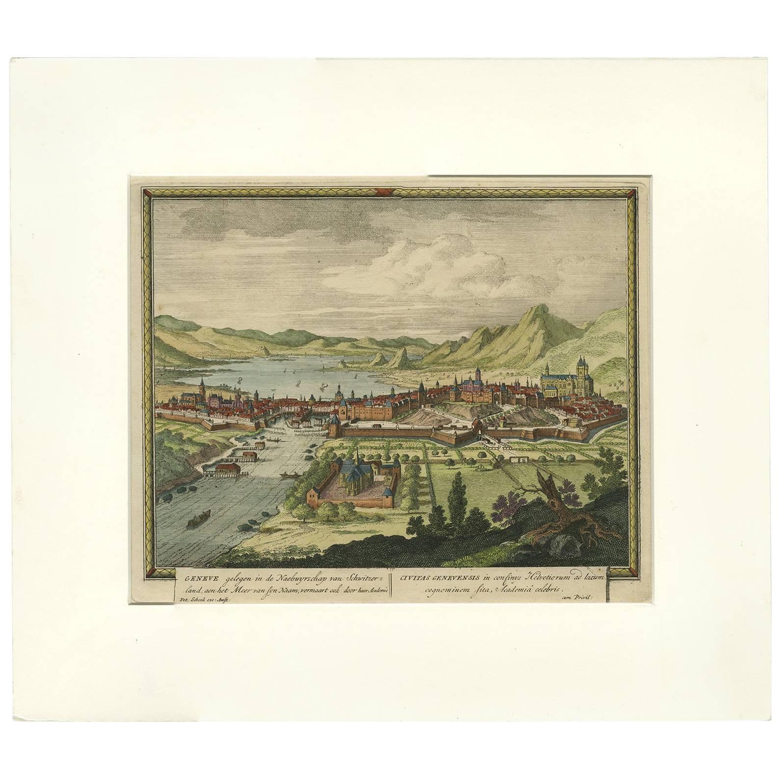
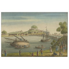
Original Hand-coloured Antique Print of Geneva, Switzerland, circa 1702
By Pieter Schenk the Elder
Located in Langweer, NL
Panoramic view of Geneva, Switzerland. Engraved and published in Amsterdam by Pieter Schenk (1660 - 1718/1719). Titles in Dutch, to left, and Latin. This print originates from Schenk...
Category
Antique Early 18th Century Prints
Materials
Paper

$474 Sale Price
20% Off
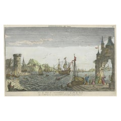
Vue de Bayonne du Côté du Port – Hand-Colored Optical Print by Basset, c.1790
Located in Langweer, NL
Vue de Bayonne du Côté du Port – Hand-Colored Optical Print by Basset, Paris circa 1790
This beautifully detailed hand-colored optical print, titled 'Vue de Bayonne du côté du Port'...
Category
Antique Late 18th Century French Prints
Materials
Paper
Contemporary Handcolored Optical View of Constantinople, ca.1760
Located in Langweer, NL
"Vue du Port de Constantinople, prise du côté du Nord". Contemporary handcolored optical view, Paris, J. Chereau, ±1760.
Description: This contemporary handcolored optical view, tit...
Category
Antique 1760s Prints
Materials
Paper
$853 Sale Price
20% Off
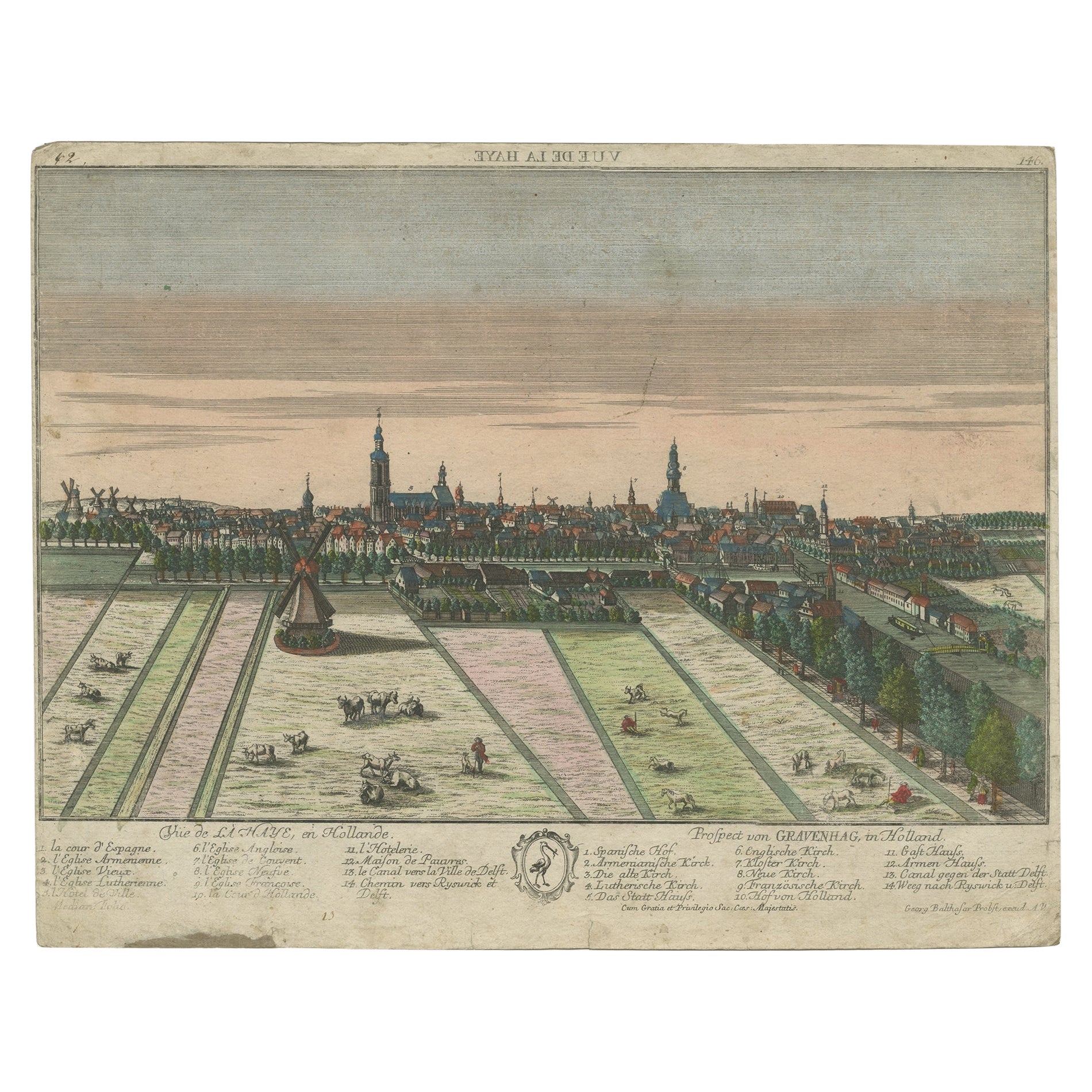
Original Antique Hand-Colored Optica Print of the Hague, C.1760
Located in Langweer, NL
Antique print titled 'Vue de la Haye en Hollande - Prospect von Gravenhag in Holland'. Beautiful view of The Hague, the Netherlands. This is an optical print, also called 'vue optiqu...
Category
Antique 18th Century Prints
Materials
Paper
$345 Sale Price
20% Off
You May Also Like
Italian Hand Colored Engraving, A View of the Great Arsenal at Venice, May 1794
Located in Atlanta, GA
in addition to the aforementioned title the engraving reads, "which has two gates, one for the workmen to enter at, one for the ships", "Published according to Act of Parliament...
Category
Antique 1790s Italian Neoclassical Prints
Materials
Paper
View of Seravalle, Italy: A 16th Century Hand-colored Map by Braun & Hogenberg
By Franz Hogenberg
Located in Alamo, CA
This is an original 16th century copperplate originally hand-colored engraved map of View of Seravalle, Italy entitled "Seravallum Celeberrimum Marchiae Tarvisiniae in Agro Foro Juliensi Opp. - Seravalli, quam vides, Spectator, iconem, operi huic nostro suis sumptib. . . ." by Georg Braun & Franz Hogenberg, from their famous city atlas "Civitates Orbis Terrarum", published in Augsberg, Germany in 1575.
The map depicts a view of Seravalle, now Vittorio Veneto, in San Marino, Italy, north of Venice, in a topographically accurate bird's-eye view from the south. A water-filled moat is seen to the south of the city walls and farmland to the east. Two men are depicted standing on a hill in the lower right in conversation next to grain sacks and a grazing horse, while a younger man behind them to the right herds a mule carrying presumably pigs. A very colorful and ornate title cartouche is in the upper center and coat-of-arms are in the right and left upper corners. Serravalle lies in an idyllic setting in the foothills and surrounded by orchards. St Mary's Cathedral with its tall bell tower is prominent in the center of the town. The marketplace and town hall with a bell tower in the square are depicted. Houses and shops are around the main square. Serravalle's importance as an agricultural centre is emphasized by the figures in the foreground. In 1337 Serravalle was conquered by the Republic of Venice. In 1866 the town was united with neighbouring Ceneda to form the town of Vittorio Veneto.
The following is an English translation of an excerpt from the French description of the city on the back of the map: "Serravalle, a market town renowned for cloth, wine and grain, is in such a beautiful situation that the number of its inhabitants, attracted by the loveliness of the place, has grown so much at times that the wall encircling it has had to be enlarged for the third time. The city with the surrounding town once belonged to the Church in Ceneda as an imperial fief. It subsequently became the seat of the Da Camino family (a princely house that at that time was one of the five most noble in all Italy). Now the city is under the sway of the Venetians but is prudently governed by them. For they send only one city councillor with instructions to ensure that justice prevails and to collect duties. In all else, power lies in the hands of the noble families."
This is a translation of the Latin in the title cartouche on the front: "The picture of the town of Serravalle, which you see, viewer, has been contributed to our work entirely at his own expense by Minutius, son of Hieronymus Minutius, a noble gentleman and one renowned for the far-reaching competence of his jurisdiction. We saw him sojourning in Cologne, where he was on business for Gregory XIII; while our good wishes accompany him, we should also like to accompany him on his way with this remembrance, even though it might be against his will, so that even those who have not seen him may learn of his excellence. However, those who do not yet know him will also see his excellence if God the Almighthy does not summon erring souls too soon back to the eternal seat of the Blessed."
References: Van der Krogt 4, 4728, State 1; Taschen, Braun and Hogenberg, p.331; Fauser, #14960
This striking hand-colored city view is printed on laid, chain-linked paper with wide margins. The sheet measures 16" high by 21" wide. There is a central vertical fold as issued and French text on the verso, with Latin on the front. There is some discoloration in the upper and right margins which may represent some watercolor paint from the time of the original hand-coloring of the map. There is a small hole to the right of the upper portion of the vertical fold, which is only visible when held up to light and an area of reinforcement on the verso of the lower vertical fold. The map is otherwise in very good to excellent condition.
Braun and Hogenberg's 'The Civitates Orbis Terrarum' was the second atlas of maps ever published and the first atlas of cities and towns of the world. It is one of the most important books published in the 16th century. Most of the maps in the atlas were engraved by Franz Hogenberg and the text, with its descriptions of the history and additional factual information of the cities, was written by a team of writers and edited by Georg Braun. The work contained 546 bird-eye views and map views of cities and towns from all over the world. It gave graphic representation of the main features of the illustrated cities and towns, including the buildings and streets. Although the ordinary buildings are stylized, the principal buildings are reproduced from actual drawings created on location. The principal landmarks and streets can still be recognized today. In addition, the maps often include the heraldic arms of the city, the nature of the surrounding countryside, the important rivers, streams and harbors, even depicting stone bridges, wooden pontoons, flat-bottomed ferries, ships and working boats, wharves and jetties, as well as land-based activities, including horsemen, pedestrians, wagons, coaches, and palanquins. Small vignettes are often included which illustrate the trade, occupations and habits of the local inhabitants, such as agriculture, paper-making and textiles, as well as local forms of punishment, such as gibbets, wheels, floggings etc. Large figures dressed in their local costume are often presented out of proportion in the foreground. The aim of the authors was to give as much information as possible in a pleasing visual form. They succeeded in creating maps that were both informative and decorative works of art. The atlas is a wonderful glimpse of life in medieval Europe.
Georg Braun (1541-1622) was German Catholic...
Category
16th Century Old Masters Landscape Prints
Materials
Engraving

Hand Colored View of the Piazza Navona by Gomar Wouters, Antwerp 1649, c1724
Located in valatie, NY
Hand Colored View of the Piazza Navona in Rome, with the Church of St Agnese at the Left and Bernini's Fountain in the Middle. By Gomar Wouters, (also called Gommarus Wouters) Flemis...
Category
Antique 18th Century Italian Prints
Materials
Glass, Wood, Paper

Hand Colored Copperplate Engraving of Copenhagen, Denmark
Located in Kastrup, DK
Hand-colored copperplate engraving depicting an interesting old view of Copenhagen seen from Frederiksberg Castle Gardens, approximate. 1790-1800.
Framed in a mahogany frame from sam...
Category
Antique Late 18th Century Danish Louis XVI Prints
Materials
Glass, Mahogany, Paper
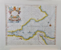
Edinburgh, Scotland: An Original 17th C. Hand-Colored Engraved Sea Chart
By Captain Greenvile Collins
Located in Alamo, CA
This hand-colored sea chart is entitled "Edinburgh Firth" from "Great Britain's Coasting Pilot. Being a New and Exact Survey of the Sea-Coast of England" by Captain Greenville Collin...
Category
Late 17th Century Landscape Prints
Materials
Engraving
Johann Georg Rosenberg (1739-1808) Hand Colored Engravings, Berlin & Amsterdam
Located in Bridgeport, CT
"Grand Place du Chateau et de la Rue Royale prise du Coee des Arcades". A view of the Berlin city square with the old neoclassical palace decorated with sculptures along the roof and...
Category
Antique 18th Century European Renaissance Prints
Materials
Gesso, Glass, Giltwood, Paper

More Ways To Browse
Engraved Crown
Italian Coat Of Arms
Sottsass Oak
Sphinx Clock
Spotted Fur
Steel Brass Bar Cart
Swatow Porcelain
Tall Filing Cabinets
Teak Bed Frame Queen
Thorvaldsen Museum
Tiered Tea Stand
Tiger Maple Cabinet
Turkish Tea Glasses Set
Used Furniture Brentwood
Verdigris Garden Sculpture
Vintage African Dolls
Vintage Bed Frames Uk
Vintage Blue Delft Plate