Items Similar to Panoramic View of Isfahan in 17th Century Persia by J.C. Haffner, ca.1690


Want more images or videos?
Request additional images or videos from the seller
1 of 8
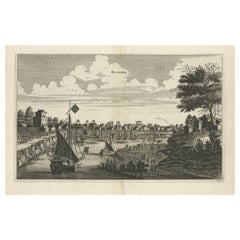
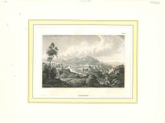
Panoramic View of Isfahan in 17th Century Persia by J.C. Haffner, ca.1690
$1,345.10
$1,681.3820% Off
£990.67
£1,238.3320% Off
€1,120
€1,40020% Off
CA$1,829.91
CA$2,287.3920% Off
A$2,033.43
A$2,541.7920% Off
CHF 1,065.54
CHF 1,331.9320% Off
MX$24,936.44
MX$31,170.5520% Off
NOK 13,590.35
NOK 16,987.9420% Off
SEK 12,785.30
SEK 15,981.6320% Off
DKK 8,526.39
DKK 10,657.9820% Off
Shipping
Retrieving quote...The 1stDibs Promise:
Authenticity Guarantee,
Money-Back Guarantee,
24-Hour Cancellation
About the Item
Panoramic View of Isfahan in the Late 17th Century by J.C. Haffner
The translation of the German text on the engraving:
"A. The Meidan or Great Market and Promenade Square in front of the Royal Palace in Isfahan. B. The Royal Palace including the Harem. C. A Persian mosque or temple. D. The Armenian women's temple. E. The Dutch residence. F. The English residence. G. The Death-Cry Church. It is a high tower, from top to bottom filled with nothing but bones and other skulls, and there are many thousands."
About the Engraving:
- Engraver and Publisher: The specific names of the engraver and publisher are not provided on the engraving itself. However, this type of detailed and historical urban scene is often attributed to European engravers who specialized in documenting notable cities and places during their travels or from reports.
- Year: The exact year of this engraving is not provided but such engravings were made in the late 17th to early 18th centuries, a period when European interest in the Persian Empire (modern-day Iran) was quite high.
Additional Information:
- Historical Context: This print depicts the city of Isfahan, which was a significant center of culture, commerce, and politics in Persia, especially during the Safavid dynasty. The Meidan mentioned is likely the Naqsh-e Jahan Square, a grand square that was a central feature of Isfahan.
- Architectural Significance: The print showcases a mix of Persian and colonial European architectural elements, reflecting the international presence in Isfahan at the time, including Dutch and English trading posts and residences.
This print serves as a valuable historical record of Isfahan's urban landscape during a period of great prosperity and architectural development.
More about the engraver J.C. Haffner and the historical context of Isfahan during the period the print was made.
J.C. Haffner
Biography:
- Full Name: Johann Christoph Haffner
- Active Period: Late 17th to early 18th century
- Nationality: German
- Profession: Engraver and cartographer
Work and Style:
- J.C. Haffner was renowned for his intricate engravings that depicted urban landscapes, historical sites, and notable buildings. His works often included detailed annotations and were used for both educational and decorative purposes.
- His engravings were characterized by precise line work, detailed architectural renderings, and comprehensive captions that provided context and historical information about the depicted scenes.
- Haffner's works were popular among European audiences who had a keen interest in exotic and faraway places, and they served as valuable records of those locations at the time.
Historical Context of Isfahan
Isfahan in the 17th Century:
- **Capital of Persia:** Isfahan became the capital of the Safavid Empire under Shah Abbas I (reigned 1588–1629). Shah Abbas I initiated a major transformation of the city, making it a political, economic, and cultural hub.
- **Urban Development:** The city was known for its stunning architecture, grand boulevards, lush gardens, and significant buildings. Key developments included the construction of the Naqsh-e Jahan Square (Imam Square), mosques, palaces, and bridges that are considered masterpieces of Persian architecture.
Cultural Significance:
- **Cultural Melting Pot:** Isfahan was a melting pot of cultures due to its role as a major trading center. It attracted merchants, artists, and scholars from various parts of the world, including Europe, India, and China.
- **European Influence:** The Safavid rulers fostered diplomatic and commercial relations with several European powers. This period saw the establishment of various European trading posts and residences in the city, as depicted in Haffner's engraving.
Key Landmarks Depicted in the Engraving:
- **Naqsh-e Jahan Square:** Also known as Imam Square, this grand square was the centerpiece of Shah Abbas I's urban development plan. It is surrounded by important buildings such as the Shah Mosque, the Ali Qapu Palace, and the Sheikh Lotfollah Mosque.
- **Royal Palace and Harem:** The Royal Palace complex included various buildings and gardens, serving as the residence of the Shah and his court.
- **Mosques and Temples:** The engraving mentions Persian mosques and Armenian women's temples, highlighting the religious diversity in the city.
- **European Residences:** The Dutch and English residences reflect the presence and influence of European traders and diplomats in Isfahan.
Legacy:
- Isfahan's architectural and cultural achievements during the Safavid era left a lasting legacy. The city's historical monuments are recognized as UNESCO World Heritage sites and continue to attract scholars and tourists interested in Persian history and culture.
Summary
J.C. Haffner's engraving of Isfahan captures a moment in time when the city was at the height of its splendor under the Safavid dynasty. His detailed and informative style provides valuable insights into the architectural and cultural landscape of Isfahan, making his work an important historical document. The engraving highlights the city's significance as a center of trade, culture, and diplomacy, showcasing its rich and diverse heritage.
Engravings of well-known cities or historical events from the 17th century by J.C. Haffner have been known to sell for $1,000 to $3,000 at reputable auction houses. Engravings in excellent condition with clear provenance can reach upwards of $5,000.
- Dimensions:Height: 11.82 in (30 cm)Width: 12.01 in (30.5 cm)Depth: 0 in (0.02 mm)
- Materials and Techniques:Paper,Engraved
- Period:1690-1699
- Date of Manufacture:ca. 1690
- Condition:Repaired: Old tape repairs or support on the reverse. Fair condition. Visible creases, especially along the fold lines, and the edges show wear. The details in the engraving remain sharp and clear, with a few light brownish spots. Please study the image carefully.
- Seller Location:Langweer, NL
- Reference Number:Seller: BG-13803-61stDibs: LU3054340257252
About the Seller
5.0
Recognized Seller
These prestigious sellers are industry leaders and represent the highest echelon for item quality and design.
Platinum Seller
Premium sellers with a 4.7+ rating and 24-hour response times
Established in 2009
1stDibs seller since 2017
2,494 sales on 1stDibs
Typical response time: 1 hour
- ShippingRetrieving quote...Shipping from: Langweer, Netherlands
- Return Policy
Authenticity Guarantee
In the unlikely event there’s an issue with an item’s authenticity, contact us within 1 year for a full refund. DetailsMoney-Back Guarantee
If your item is not as described, is damaged in transit, or does not arrive, contact us within 7 days for a full refund. Details24-Hour Cancellation
You have a 24-hour grace period in which to reconsider your purchase, with no questions asked.Vetted Professional Sellers
Our world-class sellers must adhere to strict standards for service and quality, maintaining the integrity of our listings.Price-Match Guarantee
If you find that a seller listed the same item for a lower price elsewhere, we’ll match it.Trusted Global Delivery
Our best-in-class carrier network provides specialized shipping options worldwide, including custom delivery.More From This Seller
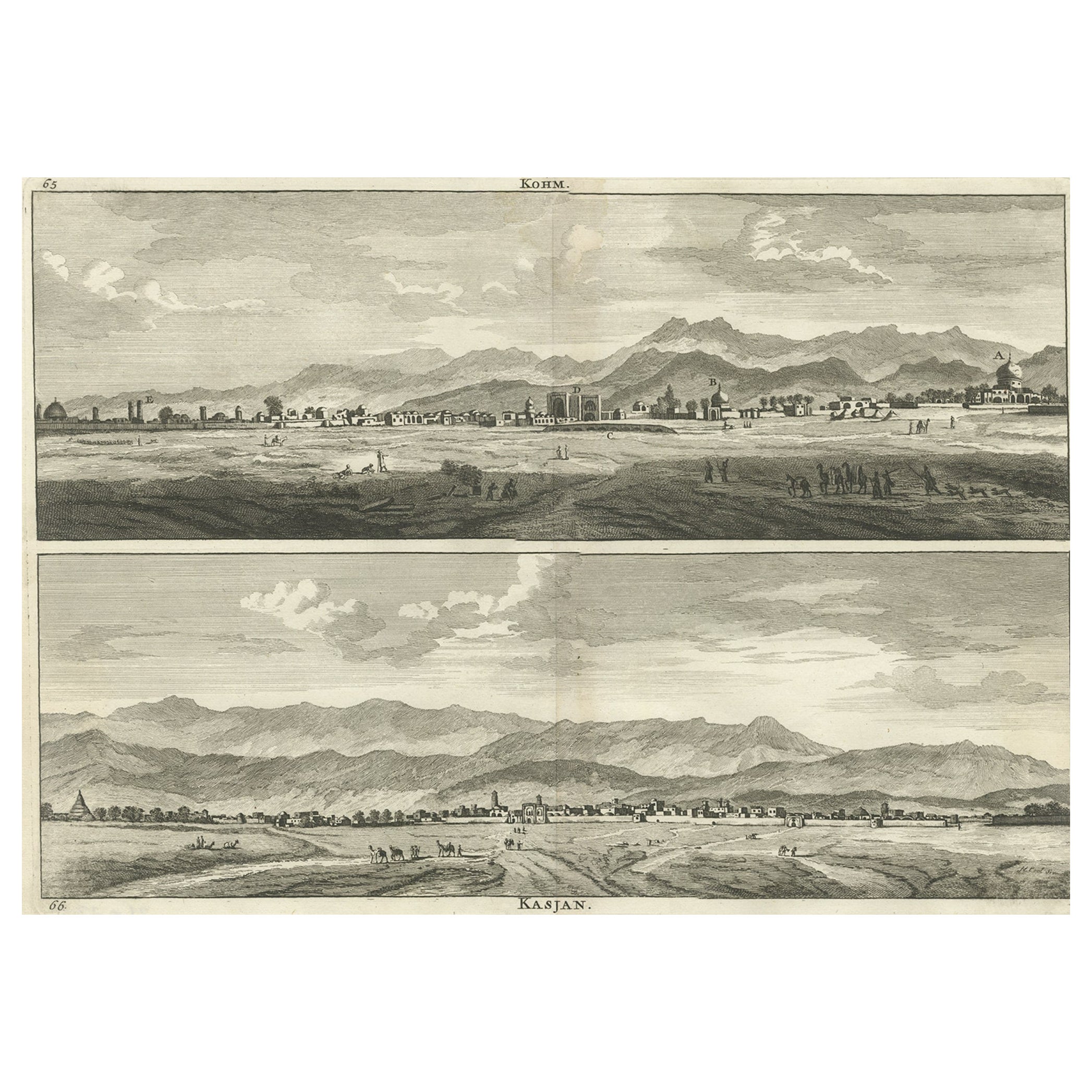
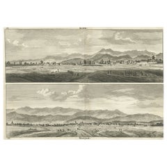
View AllRare Antique Engraving with Views of Qom and Kashan in Iran, 1711
Located in Langweer, NL
Antique print titled 'Kohm - Kasjan'. Old print with two views: one is Qom, the other Kashan. Both are in Iran (then known as Persia). This print originates from 'Cornelis de Bruins...
Category
Antique 18th Century Prints
Materials
Paper
$326 Sale Price
20% Off
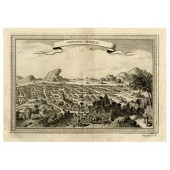
Copper Engraving with a Panoramic View of Mexico City, 1754
Located in Langweer, NL
Antique print titled 'Nouveau Mexico'.
Copper engraving with a panoramic view of Mexico city. This print originates from 'Histoire générale des voyages, ou nouvelle collection de...
Category
Antique 1750s Prints
Materials
Paper
$528 Sale Price
20% Off
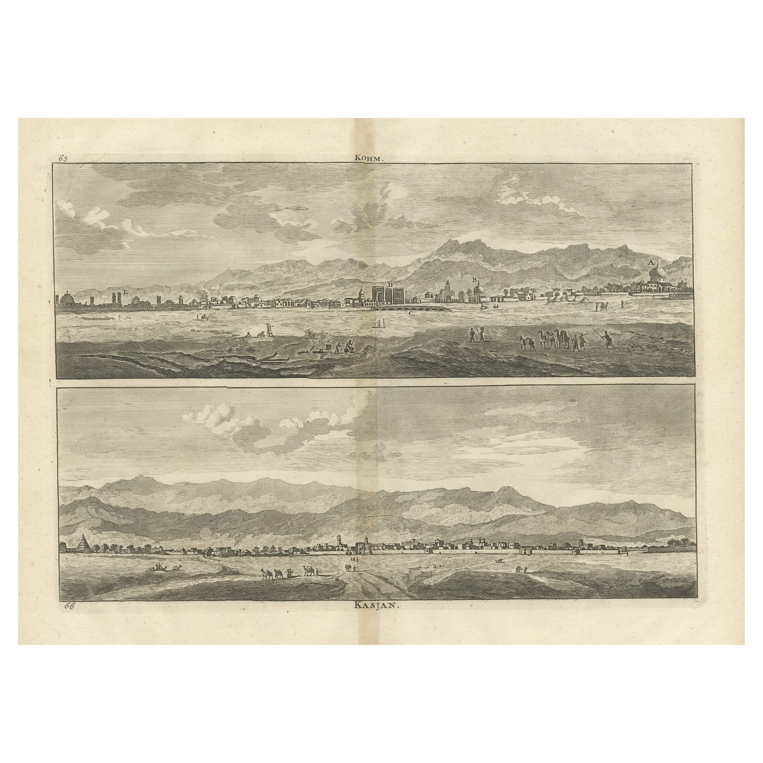
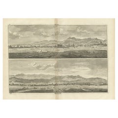
Antique Print with Views of Qom and Kashan, Persia, Iran
Located in Langweer, NL
Antique print titled 'Kohm - Kasjan'. Old print with two views: one is Qom, the other Kashan. Both are in Iran (then known as Persia).
Published by C. de Bruijn, circa 1700. Corne...
Category
Antique Early 18th Century Prints
Materials
Paper
$278 Sale Price
20% Off
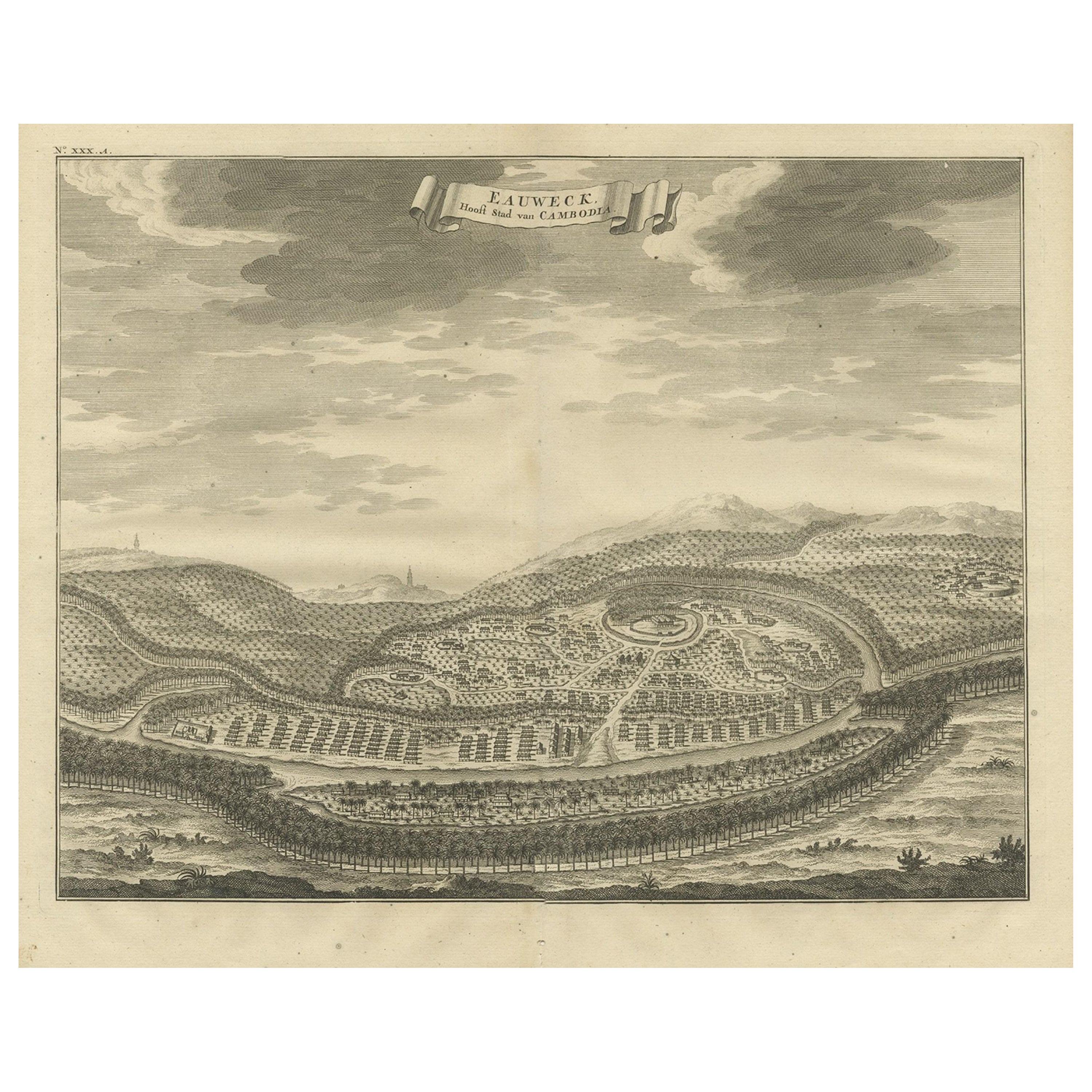
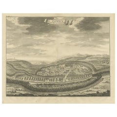
Panoramic Engraved View of the Town of Longvek 'or Lavek' in Cambodia, ca.1726
Located in Langweer, NL
Description: Antique print titled 'Eauweck, Hooft Stad van Cambodia'. Decorative panoramic view of the town of Longvek (or Lavek) in Cambodia. It was the second capital city during t...
Category
Antique 1720s Prints
Materials
Paper
$816 Sale Price
20% Off
Free Shipping
Antique Copper Engraving of the City of Kuchin in China, 1668
By Johannes Nieuhof
Located in Langweer, NL
Antique print China titled 'Kuching'.
Old print depicting a view on the Chinese city of Kuching or Kuchin (Gui Jiang, Kuei Chiang), near the river Gui (Guei). This area is close ...
Category
Antique 17th Century Prints
Materials
Paper
$326 Sale Price
20% Off
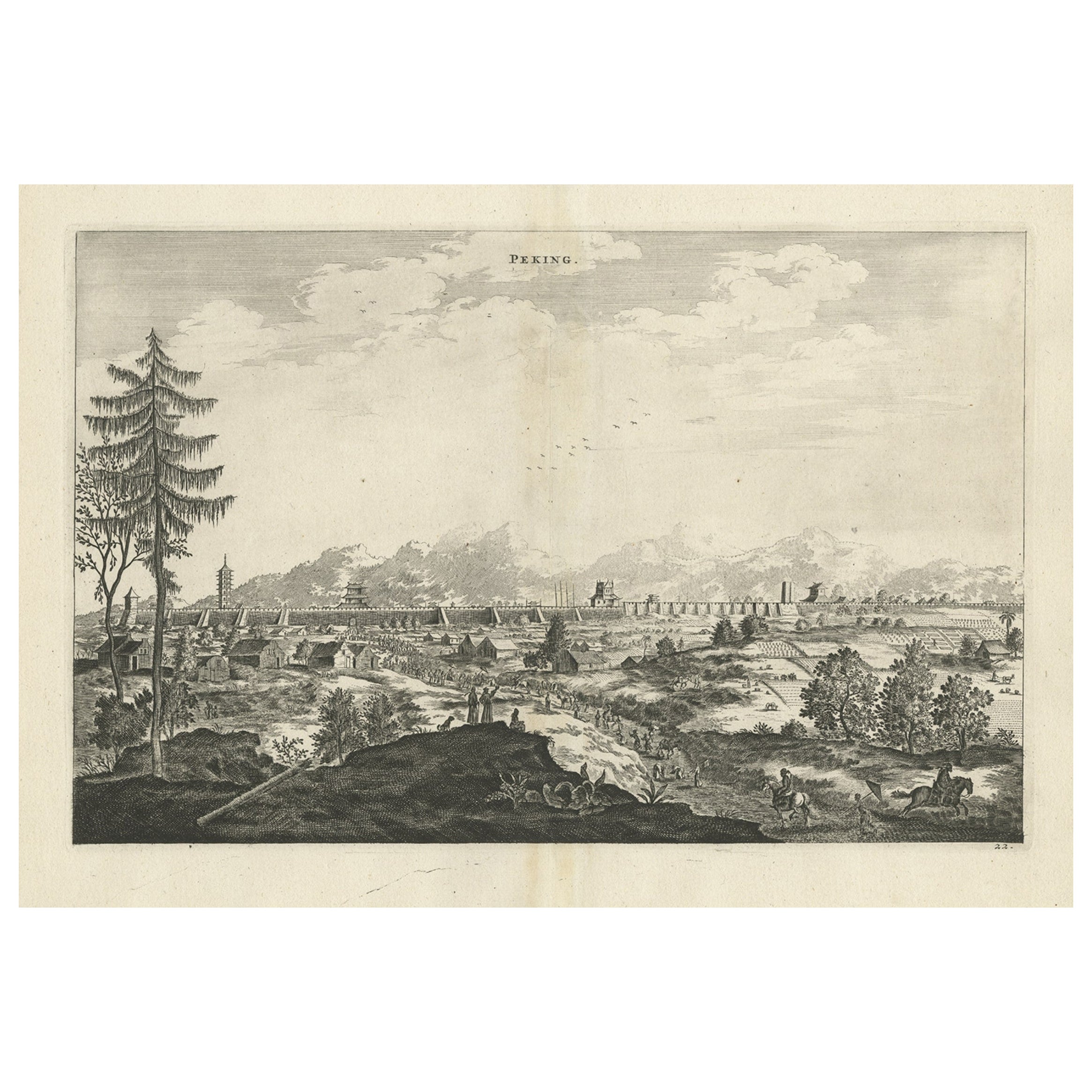
Original Copper Engraved Antique Print of the City of Bejing in China, 1668
By Johannes Nieuhof
Located in Langweer, NL
Antique print China titled 'Peking'. Old print depicting a view of Bejing in China with its ramparts. On the left a pagoda. This print originates from the Latin edition of Nieuhof's ...
Category
Antique 17th Century Prints
Materials
Paper
$518 Sale Price
20% Off
You May Also Like
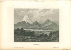
Ancient View of Teheran - Original Lithograph - Early 19th Century
Located in Roma, IT
Ancient View of Teheran is an original modern artwork realizedin the first half of the 19th Century.
Original B/W Lithograph on Ivory Paper.
Inscripted on the lower margin: Tehera...
Category
Early 19th Century Modern Figurative Prints
Materials
Lithograph
View of Antequera - Etching by G. Braun and Franz Hogenberg - Late 16th Century
Located in Roma, IT
This view of Antiqvera is an original etching realized by George Braun and Franz Hogenberg, as part of the famous Series "Civitates Orbis Terrarum".
...
Category
16th Century Figurative Prints
Materials
Etching
Ancient View of Carlsbad - Original Lithograph - First Half 19th Century
Located in Roma, IT
Ancient View of Carlsbad is an original modern artwork realized in Germany in the first half of the 19th Century.
Original B/W Lithograph on Ivory Paper.
Inscripted on the lower m...
Category
Early 19th Century Old Masters Figurative Prints
Materials
Lithograph
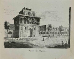
Royal Palace in Isfahan - Lithograph - 1862
Located in Roma, IT
Royal palace in Isfahan is a lithograph realized in 1864.
Good conditions.
The artwork belongs to the Suite Uses and customs of all the peoples of the universe, or History of the ...
Category
1840s Modern Figurative Prints
Materials
Lithograph
Granada, Map from "Civitates Orbis Terrarum" - by F.Hogenberg - 1575
By Franz Hogenberg
Located in Roma, IT
"Granada", from the collection "Civitates Orbis Terrarum", Cologne, T. Graminaeus, 1575.
Very nice B/W Aquatint, representing a View of Granada, from the East, which was perhaps t...
Category
16th Century Figurative Prints
Materials
Etching, Aquatint
City of Loja - Etching by G. Braun and F. Hogenberg - Late 1500
By Franz Hogenberg
Located in Roma, IT
City of Loja (ancient name: Loxa) is an original etching realized by Georg Braun and Franz Hogenberg as part of the famous Atlas "Civitates Orbis Terra...
Category
16th Century Figurative Prints
Materials
Etching
More Ways To Browse
J Bonal
German Bone China
Great City Traders
Rococo Dolphin
Rose Tea Cup
Russian Papier Mache
Sea Captains 19th
Seaweed Table
Secretary Desk Chair
Semainier Antique
Sheep Horn
Shigaraki Pottery
Sho Modern
Silver Spice Box
Spanish Oak Buffet
Spode Bone China
Stained Glass Transom Windows
Sterling Silver Letter Holder