Items Similar to Personification of Fortitude as a Modestly Dressed Seated Female Figure, ca.1780


Want more images or videos?
Request additional images or videos from the seller
1 of 5
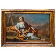
Personification of Fortitude as a Modestly Dressed Seated Female Figure, ca.1780
$160.39
$200.4820% Off
£120.05
£150.0720% Off
€136
€17020% Off
CA$220.74
CA$275.9220% Off
A$246.03
A$307.5420% Off
CHF 129.09
CHF 161.3620% Off
MX$3,004.48
MX$3,755.6020% Off
NOK 1,634.50
NOK 2,043.1320% Off
SEK 1,544.86
SEK 1,931.0720% Off
DKK 1,035.33
DKK 1,294.1620% Off
About the Item
Antique print, titled: 'Fortitude.' - Personification of Fortitude as a modestly dressed seated female figure. A lion in the background. From 'The Universal Magazine of Knowledge and Pleasure'. This periodical was published between 1747 and 1814, edited by John Hinton and W. Bent.
Artists and Engravers: Anonymous.
- Dimensions:Height: 8.31 in (21.1 cm)Width: 5.04 in (12.8 cm)Depth: 0 in (0.02 mm)
- Materials and Techniques:
- Period:1780-1789
- Date of Manufacture:circa 1780
- Condition:Condition: Very good, given age. Left edge a little uneven from binding. Some offsetting from letterpress text on the opposite page. General age-related toning and/or occasional minor defects from handling. Please study scan carefully.
- Seller Location:Langweer, NL
- Reference Number:Seller: PCT-566841stDibs: LU3054327425542
About the Seller
5.0
Recognized Seller
These prestigious sellers are industry leaders and represent the highest echelon for item quality and design.
Platinum Seller
Premium sellers with a 4.7+ rating and 24-hour response times
Established in 2009
1stDibs seller since 2017
2,517 sales on 1stDibs
Typical response time: <1 hour
- ShippingRetrieving quote...Shipping from: Langweer, Netherlands
- Return Policy
Authenticity Guarantee
In the unlikely event there’s an issue with an item’s authenticity, contact us within 1 year for a full refund. DetailsMoney-Back Guarantee
If your item is not as described, is damaged in transit, or does not arrive, contact us within 7 days for a full refund. Details24-Hour Cancellation
You have a 24-hour grace period in which to reconsider your purchase, with no questions asked.Vetted Professional Sellers
Our world-class sellers must adhere to strict standards for service and quality, maintaining the integrity of our listings.Price-Match Guarantee
If you find that a seller listed the same item for a lower price elsewhere, we’ll match it.Trusted Global Delivery
Our best-in-class carrier network provides specialized shipping options worldwide, including custom delivery.More From This Seller
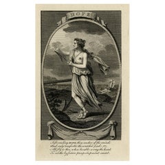
View AllAntique Print Depicting the Personification of Hope, with English 4-Liner, c1780
Located in Langweer, NL
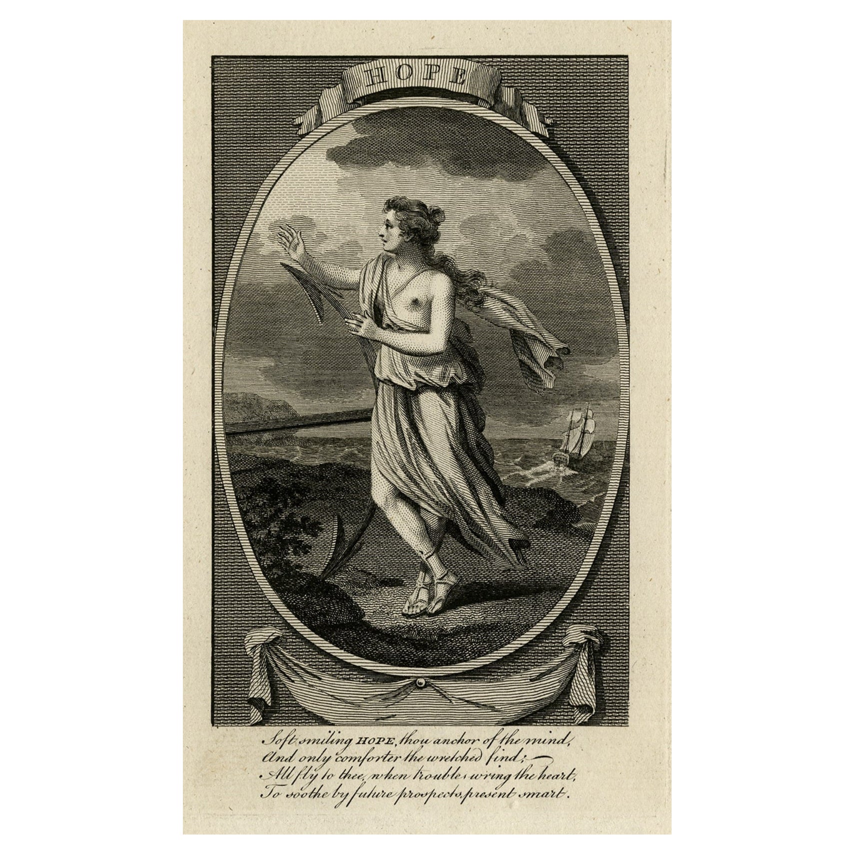
Antique print, titled: 'Hope.'
Personification of Hope, a female figure beside an anchor, with a sailing ship in the background. With a four-line English caption. From 'The Unive...
Category
Antique 1780s Prints
Materials
Paper
$198 Sale Price
20% Off
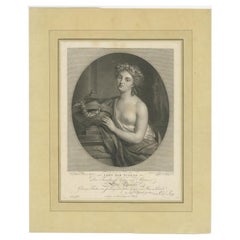
Reward of Virtue – Allegorical Portrait Dedicated to Elise Charlotte, c.1790
Located in Langweer, NL
Reward of Virtue – Allegorical Portrait Dedicated to Elise Charlotte, c.1790
This elegant allegorical engraving from the late 18th century depicts a half-draped young woman adorned ...
Category
Antique 18th Century German Prints
Materials
Paper
$339 Sale Price
20% Off
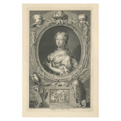
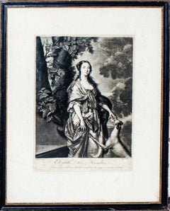
Beautiful Portrait of Anne, Princess Royal and Princess of Orange, 1750
Located in Langweer, NL
Antique portrait titled 'Anna, Kroonprinsesse van Grootbrittanje, Gemalinne van Willem de IV, Prins van Oranje'.
Beautiful portrait of Anne, Princess Royal and Princess of Orange (1709-1759). Portrayed in an oval with allegorical symbolism beneath a mirror with a snake, a shield with the royal family coat of arms and other elements.
Anne, Princess Royal and Princess of Orange, was the second child and eldest daughter of King George II of Great Britain and his consort Caroline of Ansbach. She was the wife of William IV, Prince of Orange, the first hereditary stadtholder of all seven provinces of the Northern Netherlands. She was Regent of the Netherlands from 1751 until her death in 1759, exercising extensive powers on behalf of her son William V. She was known as an Anglophile, due to her English upbringing and family connections, but was unable to convince the Dutch Republic to enter the Seven Years' War on the side of the British...
Category
Antique 1750s Prints
Materials
Paper
$320 Sale Price
20% Off
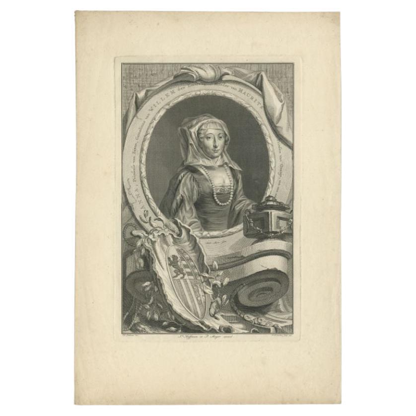
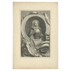
Antique Portrait of Anna of Saxony, Wife of William of Orange, 1757
Located in Langweer, NL
Antique portrait titled 'ANNA, Prinsesse van Saxen, Gemalinne van WILLEM den Eersten, Moeder van MAURITS Prinsen van Oranje, enz. enz. enz'. Portrait of Anna of Saxony, wife of William of Orange...
Category
Antique 18th Century Dutch Prints
Materials
Paper
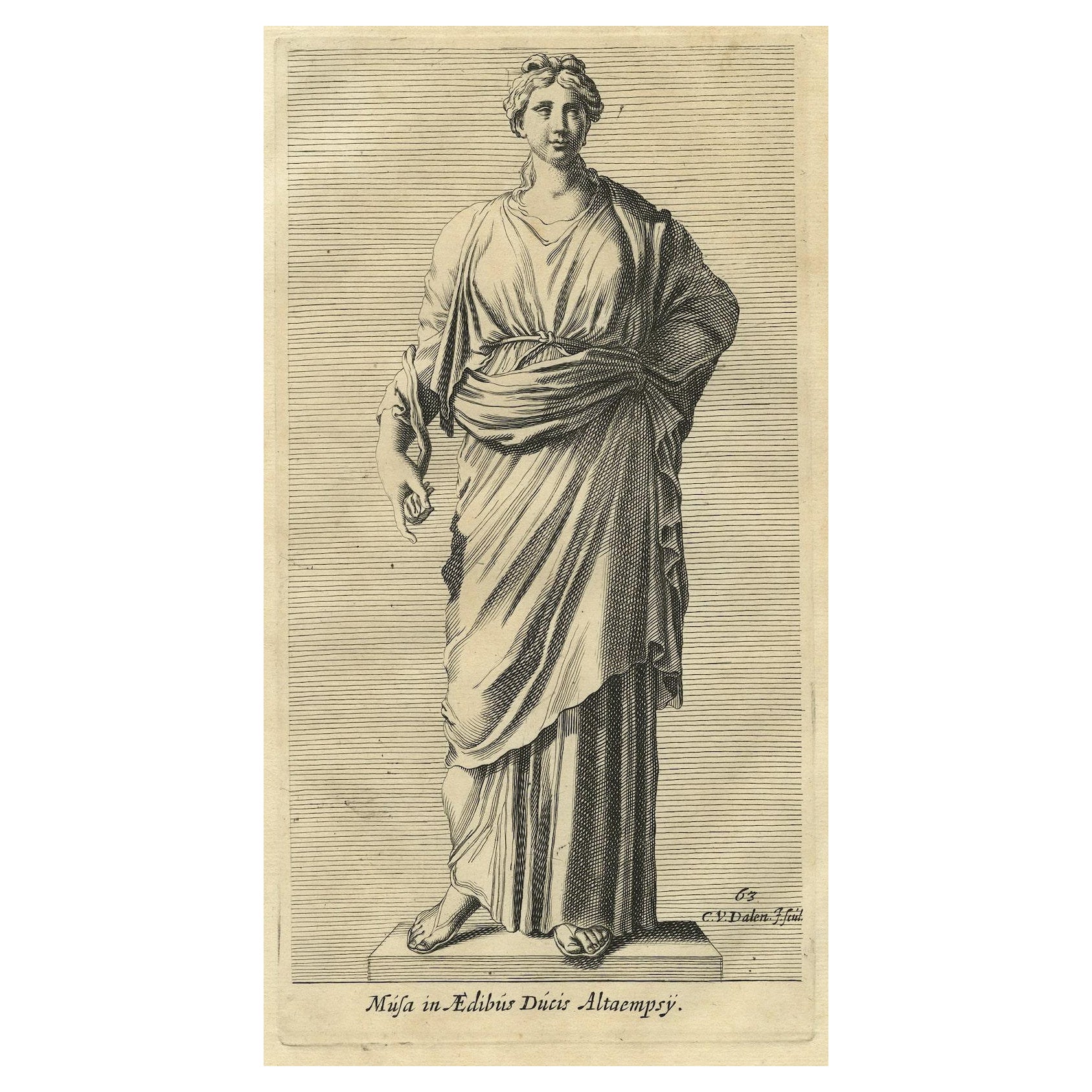
Print of a Muse, Inspirational Goddesses of Literature, Science and Arts, 1660
Located in Langweer, NL
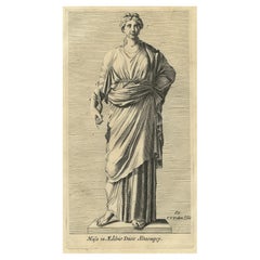
Description: Antique print, titled: 'Musa in Aedibus Ducis Altaempsy.' - Statue of a Muse in Rome. The Muses are the inspirational goddesses of literature, science, and the arts in Greek mythology.
From the 1660 Dutch edition of 'Icones et Segmenta Nobil. Signorum et Statuarum quae Romae extant' by Francois Perrier. This first Dutch edition was published by Nicolaas Visscher, printed in 1660 (Amsterdam). Although Perrier was French, he fell in love with Rome when he traveled there first in 1628 and then returning in 1635 and remaining for 10 years. While there, he completed this series of 100 views of Roman statuary in the various palaces and gardens, including the Medici and Vatican gardens and the Palazzo Farnese.
Artists and Engravers: Made by 'Cornelis van Dalen...
Category
Antique 1660s Prints
Materials
Paper
$226 Sale Price
20% Off
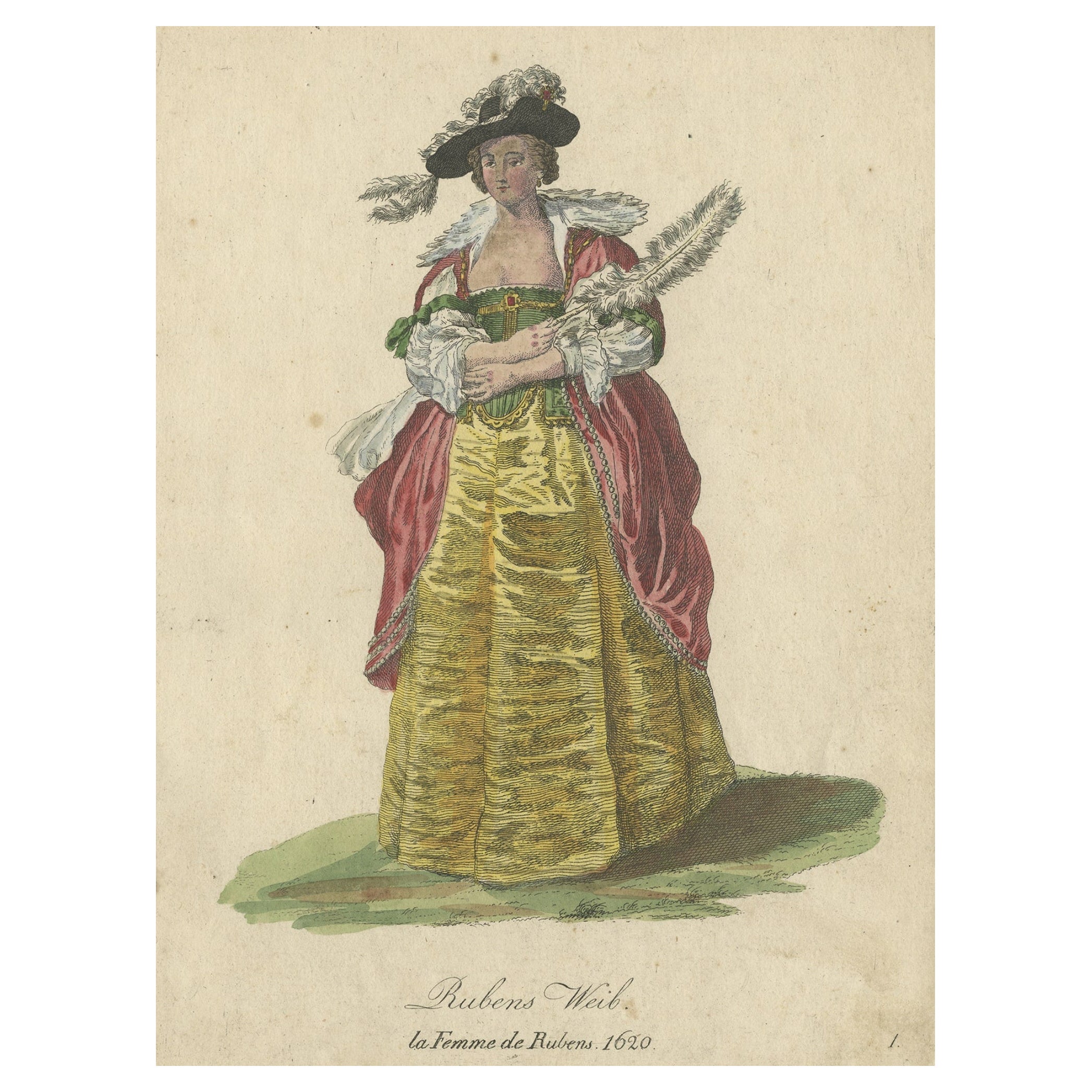
Antique Costume Print of Ruben's Wife in 1620, Published in 1805
Located in Langweer, NL
Antique costume print titled 'Rubens Weib - la Femme de Rubens'.
This print depicts Rubens's wife. Originates from a rare costume book titled 'Sammlun...
Category
Antique Early 1800s Prints
Materials
Paper

$273 Sale Price
20% Off
You May Also Like
Erato, The Muse of Lyric - Etching by Vincenzo Aloja - 18th Century
By Vincenzo Aloja
Located in Roma, IT
Erato, The Muse of Lyric from "Antiquities of Herculaneum" is an etching on paper realized by Vincenzo Aloja in the 18th Century.
Signed on the plate.
Good conditions.
The etching...
Category
Late 18th Century Old Masters Figurative Prints
Materials
Etching
Original Antique Print of The Greek Goddess, Hebe. Dated 1833
Located in St Annes, Lancashire
Wonderful image of Hebe
Fine steel engraving.
Published by Fisher. Dated 1833
Unframed.
Category
Antique 1830s English Neoclassical Prints
Materials
Paper
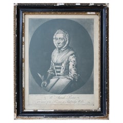
Sarah Porter, "Queen of the Touters at Tunbridge Wells" Engraving, circa 1770
Located in Lowestoft, GB
After Vander Smissen 'Mrs Sarah Porter, Queen of the Touters at Tunbridge Wells', a mezzotint, engraved by William Pether circa 1770, glazed in ebonised, ...
Category
Antique Late 18th Century English Prints
Materials
Glass, Pine, Paper
18th Century Lying Female Figure Painting by Giovanni Domenico Molinari
Located in Milan, IT
Giovanni Domenico Molinari (Caresana, 1721 - Turin, 1793)
Lying Female figure
Oil on canvas, cm 46 x. 31 - With frame, cm 56 x 42
The present painting is connected by style and treated subject, in this case a young girl lying in an idyllic landscape, to the production of small pictures of pastoral subject of the Piedmontese painter Giovanni Domenico Molinari (Caresana, 1721 - Turin, 1793).
Molinare was born in Caresana (Vercelli) on 19 July 1721 but after losing both his parents he moved to Turin. Here he became, from 1736, a pupil of the Academy of Drawing founded by the painter Claudio Francesco Beaumont (Turin, 4 July 1694 - Turin, 21 June 1766) where he remained as a pensioner until December 1755. Molinari was immediately engaged in the translation of the master’s sketches on cardboard used for the Regia manufacture of tapestries. His early success on the Turin art scene is confirmed by the fact that he joined the Compagnia di San Luca in 1756.
In 1751 he married Margherita Peiroleri, whose brothers Pietro (engraver) and Nicolò (painter) also attended the school. Remained widower count two other marriages first with Lucrezia Elisabetta Burzio and then in 1770 with Domenica Maria Ferrero.
On the death of the master in 1766 Molinari, considered by his contemporaries to be the most faithful interpreter of the master and for his elegant and Arcadian style, which clearly interprets the aesthetic taste of the court, was called to finish the works that remained unfinished, such as the altarpiece for the church of Santa Maria della Scala in Moncalieri depicting the Assumption venerated by Blessed Bernard of Baden and Saint Anthony. Molinari was also well praised by critics and Abbot Lanzi highlighted the quality of the production of historical and mythological subject for the rigorous post-marattesco classicism.
In Turin he worked for Vittorio Amedeo III of Savoy as a portrait painter, executing for him eleven canvases (between 1774 and 1775), but, since 1745, he also supplied tapestry cartoons to the local Fabbrica, of which, in 1766, he became director.
The production of paintings of sacred subjects is also lively, especially used in the decoration of the churches of the capital as the Assumption for the Hotel of Virtue and San Pietro Regalado and San Benedetto il Moro for Santa Maria degli Angeli ( Torino) He also painted tempera and oil cartoons for the same church, on the occasion of the beatification of Pacifico da San Severino (1787) and, for that of San Francesco di Paola, when Gaspare de Bono...
Category
Antique 18th Century Italian Paintings
Materials
Canvas
Elizabeth Duchess of Hamilton - Etching by W. Hamilton - Late 1700
By Sir William Hamilton
Located in Roma, IT
Beautiful portrait of Elizabeth Duchess of Hamilton, in very good conditions.
Prov.
Ederheimer Gallery N.Y.
Private Collection, Italy
Category
Late 18th Century Portrait Prints
Materials
Etching
Portrait of Woman - Original Etching by Thomas Holloway - 1810
By Thomas Holloway
Located in Roma, IT
Portrait of Woman is an original artwork realized by Thomas Holloway (1748 - 1827).
Original Etching from J.C. Lavater's "Essays on Physiognomy, Designed to promote the Knowledge and the Love of Mankind", London, Bensley, 1810.
A the bottom center the name of the man portrayed "an angelic Woman...
Category
1810s Old Masters Portrait Prints
Materials
Etching
More Ways To Browse
Lion Dress
19th Century Queen Bed Frame
1930s Mannequin
3 Drawer Commode Pair
36 Inch Chest Of Drawers
Abercrombie And Fitch Leather
Alien Table
Anglo Indian Brass Inlay
Antique Ash Trays
Antique Baby Plates
Antique Bread Cabinet
Antique Celadon Bowl
Antique Ceramic Elephants
Antique Chinese Embroidery Panel
Antique Clock Labels
Antique Glass Front Secretary
Antique Horse Tack
Antique Korean Bowl