Items Similar to Prince Henry's Naval and Land Battle during the Seven Years' War Engraved, 1667

Want more images or videos?
Request additional images or videos from the seller
1 of 10
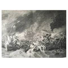
Prince Henry's Naval and Land Battle during the Seven Years' War Engraved, 1667
$440.92
$551.1520% Off
£328.23
£410.2920% Off
€368
€46020% Off
CA$603.95
CA$754.9320% Off
A$671.72
A$839.6520% Off
CHF 350.75
CHF 438.4420% Off
MX$8,174.11
MX$10,217.6420% Off
NOK 4,479.63
NOK 5,599.5320% Off
SEK 4,201.10
SEK 5,251.3720% Off
DKK 2,801.46
DKK 3,501.8220% Off
Shipping
Retrieving quote...The 1stDibs Promise:
Authenticity Guarantee,
Money-Back Guarantee,
24-Hour Cancellation
About the Item
The engraving depicts the assault and capture of the Danish fortress Friderichsodde (now known as Fredericia) located on the island of Fyn. The scene, captured on October 24, 1657, vividly illustrates the Swedish main army's takeover under the command of General Carl Gustaf Wrangel. This historical event is meticulously documented in the artwork, which showcases not only the military action but also the strategic landscape and fortifications characteristic of the time.
Erik Jönsson Graf von Dahlberg, the artist behind this work, was a prominent Swedish field marshal, architect, and fortress builder. Born in 1625 and passing in 1703, Dahlberg's contributions to military and architectural fields were significant. He was renowned for his detailed and artistically valuable drawings which served as the basis for large-scale copperplate engravings. These engravings are of substantial topographical and architectural historical importance as they provide a detailed visual account of Swedish territories during the era.
In 1661, Dahlberg began work on his magnum opus—a comprehensive geographical and historical depiction of Swedish territories, which received royal privileges. His journey in 1667-1668 to Paris for the engraving of the initial plates reflects the international scope and ambition of his project. However, the work was intermittently paused when Dahlberg was tasked in 1674 with overseeing all Swedish fortress constructions, a role that significantly impacted his career and works. The project resumed and was published in 1684, highlighting a significant period of Swedish history and military achievements under his visual documentation.
MORE ABOUT THE BATTLE:
The image is an intricate engraving depicting a battle scene. Based on the details and the text in the cartouche, the scene illustrates a significant historical battle involving Prussian forces. The presence of multiple ships and extensive fortifications suggests a combined land and naval engagement.
Key Features in the Engraving:
1. Land Battle: The forefront of the image shows numerous troops, artillery pieces, and cavalry in action, depicting the intensity and scale of the land combat.
2. Naval Elements: Ships in the background indicate that this battle had a naval component, which would have been crucial for controlling trade routes or strategic waterways.
3. Fortifications: Extensive fortifications, including bastions and protective walls, suggest a well-defended location, possibly a city or a significant stronghold.
Historical Context:
From the text, it appears the battle involves "Prinz Heinrich," referring to Prince Henry of Prussia, who was an influential military leader during the reign of his brother, Frederick the Great. Under Frederick’s rule, Prussia engaged in several key conflicts, including the Seven Years' War (1756-1763), which saw major battles across Europe and involved complex alliances.
Given the level of detail and the era suggested by the style of ships and fortifications, the battle was of the significant engagements during the Seven Years' War, where Prince Henry played a critical role. His campaigns often involved maneuvering to protect Prussia from multiple fronts, including naval engagements in the Baltic.
Interpretation:
This engraving serves not only as a historical document but also as a piece of propaganda, likely glorifying the prowess and strategic capabilities of the Prussian military under Prince Henry’s command. Such detailed engravings were commonly used to communicate the power and success of a nation's forces to a wider audience, bolstering national pride and the legitimacy of the ruling powers.
To provide a more accurate and detailed description of the specific battle or event depicted, further investigation into the text and symbols within the engraving would be necessary, as these would offer clues about the precise historical and geographical context of the scene.
- Dimensions:Height: 13.78 in (35 cm)Width: 16.93 in (43 cm)Depth: 0 in (0.02 mm)
- Materials and Techniques:Paper,Engraved
- Period:1670-1679
- Date of Manufacture:1667
- Condition:Condition: good, given age. Folds as published. Some creasing and vertical folding lines as issued. General age-related toning and/or occasional minor defects from handling. Please study scan carefully.
- Seller Location:Langweer, NL
- Reference Number:Seller: BG-138221stDibs: LU3054341200932
About the Seller
5.0
Recognized Seller
These prestigious sellers are industry leaders and represent the highest echelon for item quality and design.
Platinum Seller
Premium sellers with a 4.7+ rating and 24-hour response times
Established in 2009
1stDibs seller since 2017
2,510 sales on 1stDibs
Typical response time: <1 hour
- ShippingRetrieving quote...Shipping from: Langweer, Netherlands
- Return Policy
Authenticity Guarantee
In the unlikely event there’s an issue with an item’s authenticity, contact us within 1 year for a full refund. DetailsMoney-Back Guarantee
If your item is not as described, is damaged in transit, or does not arrive, contact us within 7 days for a full refund. Details24-Hour Cancellation
You have a 24-hour grace period in which to reconsider your purchase, with no questions asked.Vetted Professional Sellers
Our world-class sellers must adhere to strict standards for service and quality, maintaining the integrity of our listings.Price-Match Guarantee
If you find that a seller listed the same item for a lower price elsewhere, we’ll match it.Trusted Global Delivery
Our best-in-class carrier network provides specialized shipping options worldwide, including custom delivery.More From This Seller
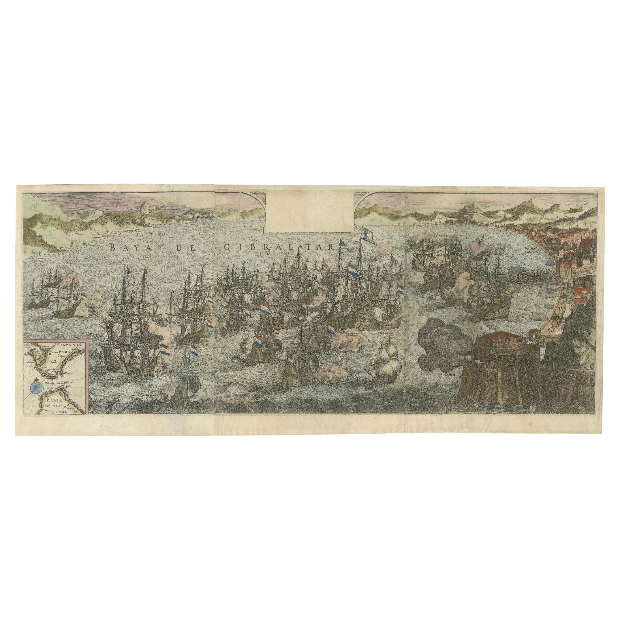
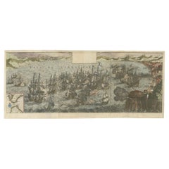
View AllRare Large 1650 Copper Engraving Depicting the Naval Battle of Gibraltar, 1607
Located in Langweer, NL
Title: Rare Large 1650 Copper Engraving Depicting the Naval Battle of Gibraltar, 1607
Description: This rare and exceptionally large copper engraving, measuring 32 x 85 cm, capture...
Category
Antique 1650s Prints
Materials
Paper
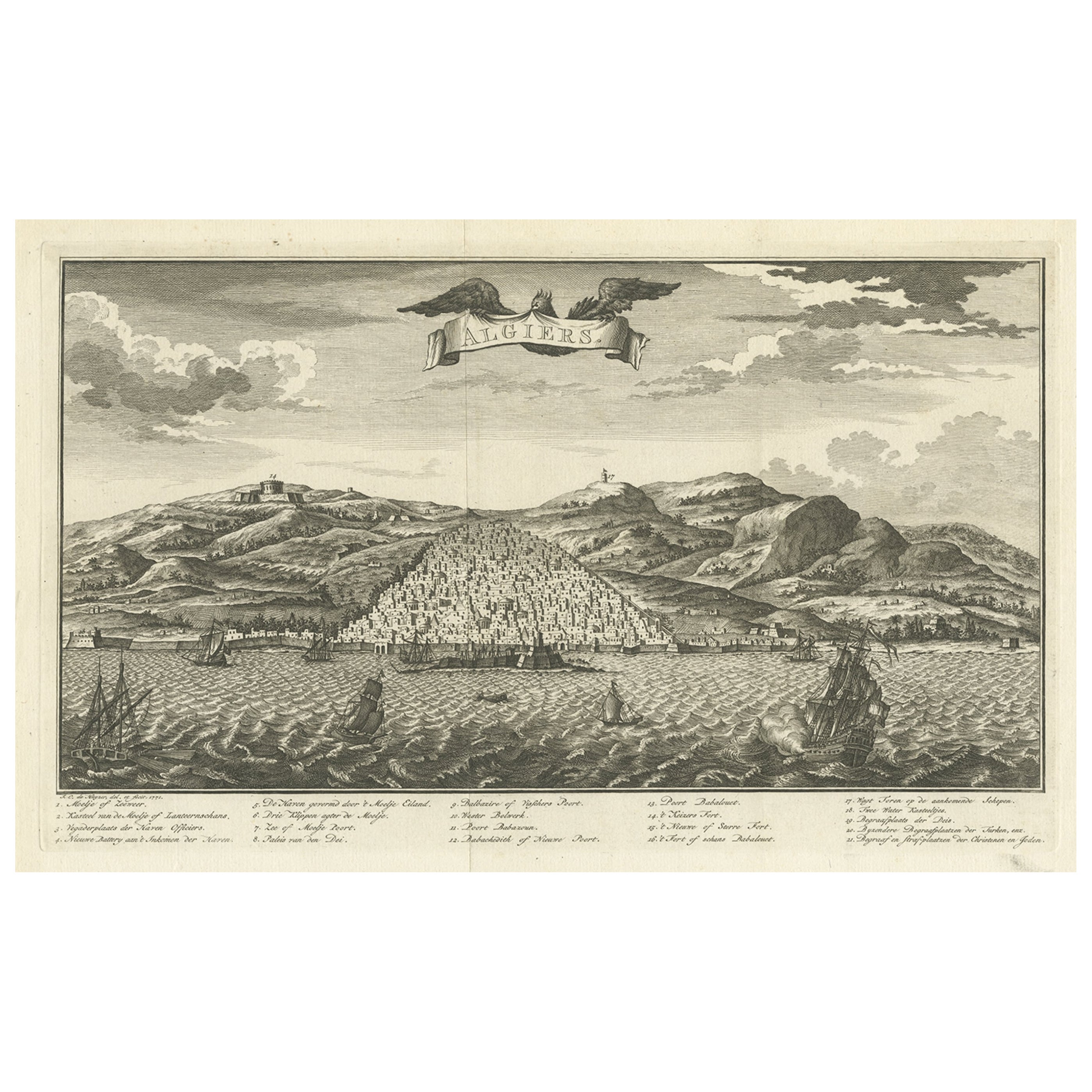
Original Antique Engraving of Algiers in Algeria, 1773
Located in Langweer, NL
Antique print titled 'Algiers'. Old print with a view of Algiers, Algeria. With Dutch legend. Originates from the first Dutch editon of an interesting travel account of Northern Afri...
Category
Antique 18th Century Prints
Materials
Paper
$469 Sale Price
20% Off
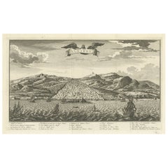
The Dardanelles in the Age of Sail: A Panoramic Etching, Ca.1765
Located in Langweer, NL
This rare and exquisite view depicts the strategic Dardanelles strait, the narrow passage between the Aegean and the Sea of Marmara with the distant cityscape of Istanbul. Part of th...
Category
Antique 1760s Prints
Materials
Paper

$1,150 Sale Price
20% Off
Free Shipping
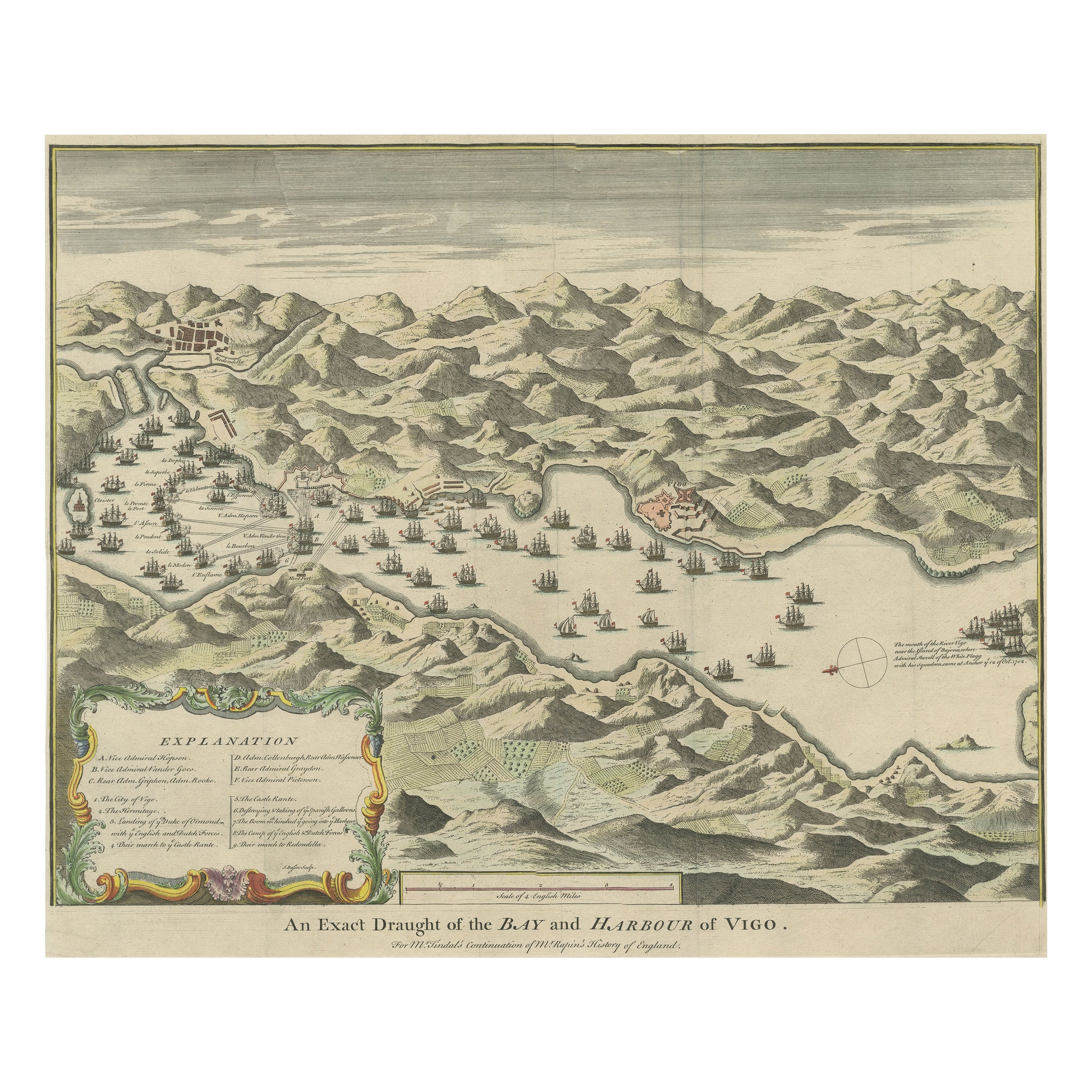
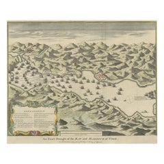
Antique Print of the Battle in 1702 of Vigo Bay or Rande, Galicia, Spain
Located in Langweer, NL
Antique print titled 'An Exact Draught of the Bay and Harbour of Vigo'. The Battle of Vigo Bay was an engagement that saw a combined Dutch/English naval force successfully capture on...
Category
Antique Mid-18th Century Prints
Materials
Paper
$843 Sale Price
20% Off
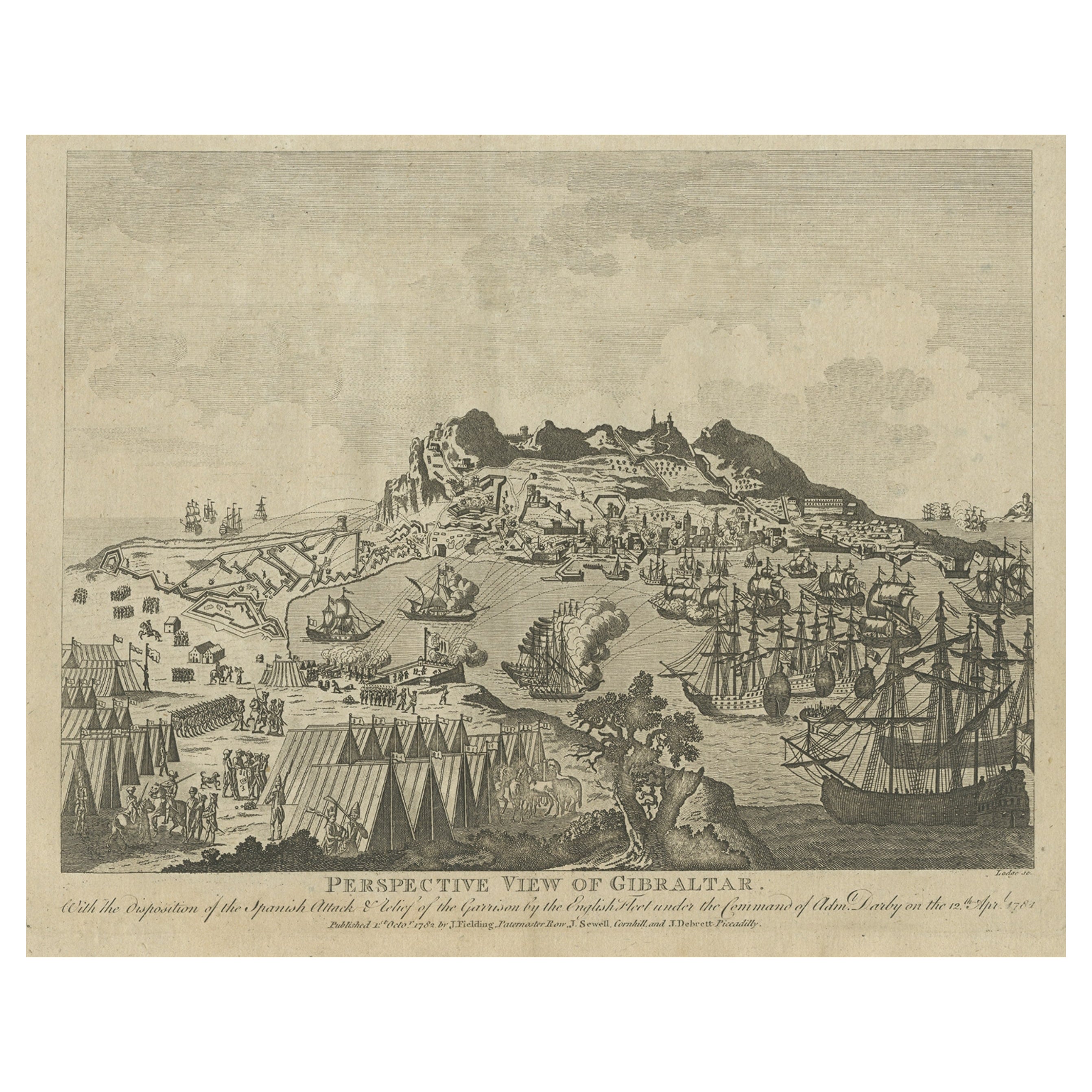
Antique Print of Gibraltar Showing the Spanish and English Fleet, 1782
Located in Langweer, NL
Antique print titled 'Perspective View of Gibraltar. With the the Disposition of the Spanish Attack, and Relief of the Garrison by the English Fleet under the command of Admiral Darby, 12 April 1781'. View of the island clearly showing the fortifications, during a bombardment, with the Spanish encampments on the left wing of the bay and a few Spanish ships...
Category
Antique 18th Century Prints
Materials
Paper
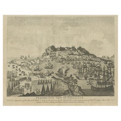
$412 Sale Price
20% Off
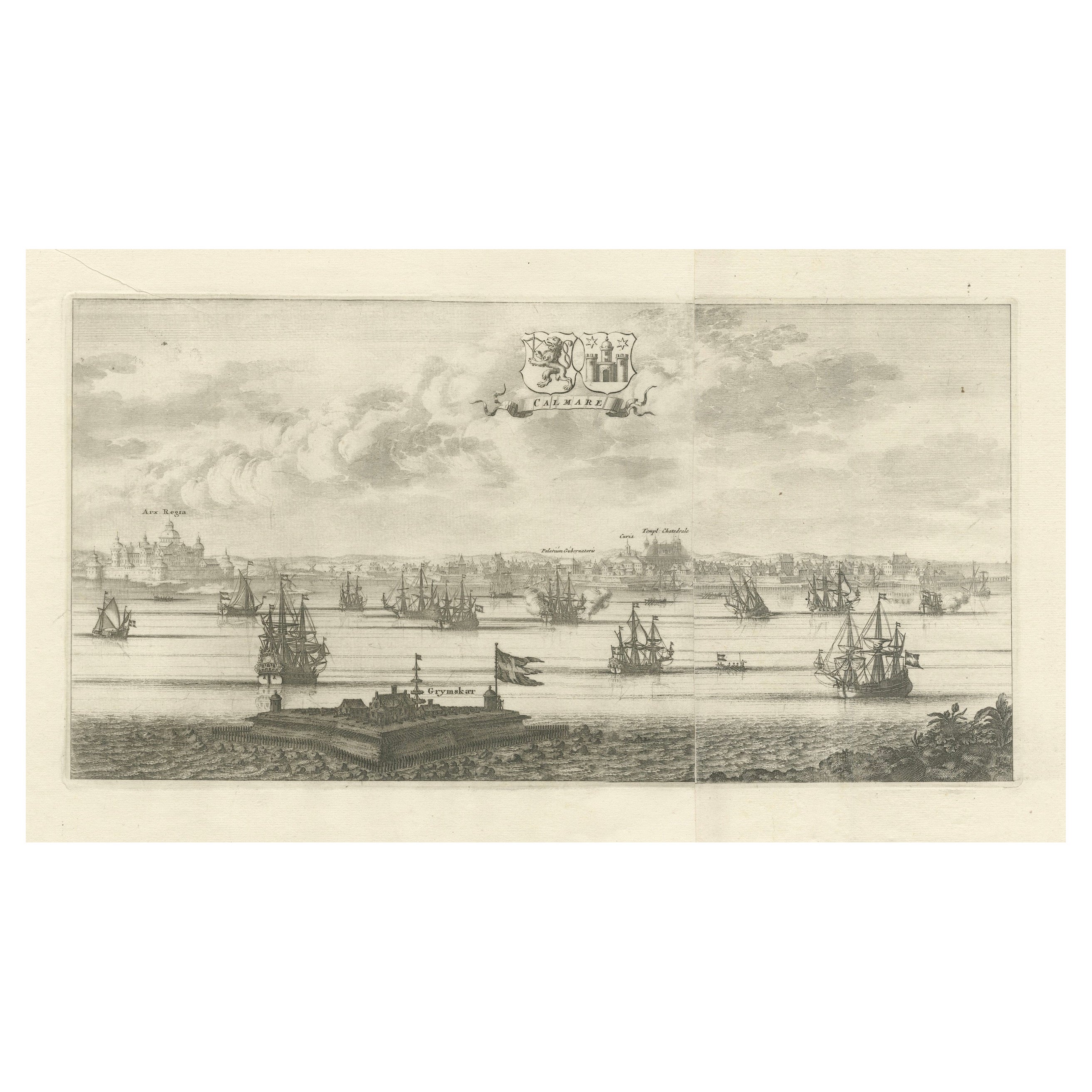
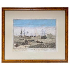
Maritime Majesty: The 17th-Century Skyline of Kalmar in Sweden, 1693
Located in Langweer, NL
The engraving depicts the city of Kalmar, a historically significant city on the east coast of Sweden. This panoramic view captures the bustling port and the city's skyline during th...
Category
Antique 1690s Prints
Materials
Paper

$431 Sale Price
20% Off
Free Shipping
You May Also Like
B.West Engraving "Naval Battle, Battle of the Houge" 18th Century
Located in Beuzevillette, FR
This magnificent engraving is entitled "Battle of La Hougue" by the engraver E.C Voysard after Benjamin West.
It depicts the Battle of Barfleur- La Hougue,...
Category
Antique 18th Century French Prints
Materials
Paper
17th-18th Century Siege of Graves Mapping Engraving By Willian III
Located in Kingston, NY
RARE French 17th-18th Century Enhanced Siege of Graves Mapping Engraving BY William III, also widely known as William of Orange,
The Siege of Grave in Dutch Brabant started by Monsie...
Category
Antique 17th Century French Prints
Materials
Paper

Early 18th Century Engraving of the Northern Whale Fishery, circa 1720
Located in Nantucket, MA
Very early 18th century Dutch woodblock engraving of the Northern Whale Fishery, circa 1720, a hand colored engraving illustrating the Dutch whaling flee...
Category
Antique 1720s Dutch Baroque Prints
Materials
Paper
19th Century Reprint of 16th Century Harbor Map of Copenhagen
Located in Haddonfield, NJ
This reprint of 1587 antique map of Copenhagen, Denmark retains its original mid-century mat and has been recently reframed in classic wood frame. The muted sepia colored map is a wo...
Category
Antique 1880s Danish Baroque Maps
Materials
Wood, Paper

Antique Voc Print Holland Malaysia Old Map Melaka History, 1663
Located in Amsterdam, Noord Holland
From my own collection I offer this impressive Antique print of the city of Malakka
A very interesting piece for collectors . It is an museum piece from the Dutch Institute of Orien...
Category
Antique 17th Century European Paintings
Materials
Paper

$293 Sale Price
20% Off
18th Century French Map and City View of Joppe/Jaffa (Tel Aviv) by Sanson
By Nicholas Sanson d'Abbeville
Located in Alamo, CA
An original antique engraving entitled "Joppe; in ’t Hebreeusch by ouds Japho; hedendaags Japha, of Jaffa; volgens d’aftekening gedaan 1668", by Nicholas Sanson d'Abbeville (1600 - 1667). This is a view of the city of Joppe (in Hebrew Japho), now called Japha or Jaffa, the harbor portion of modern day Tel Aviv, Israel as it appeared in 1668 . It depicts a very busy harbor with numerous boats. A large ship on the left appears to be firing its canons and a small ship on the right appears to be sitting very low in the water, either heavily loaded with cargo or sinking. The town is seen on the far shore with a fortress on a hill across in the background. The map is printed from the original Sanson copperplate and was published in 1709 by his descendants.
The map is presented in an ornate brown wood frame embellished by gold-colored leaves and gold inner trim with a double mat; the outer mat is cream-colored and the inner mat is black. There is a central vertical fold, as issued. There are two small spots in the lower margin and one in the upper margin, as well as two tiny spots adjacent to the central fold. 1717 is written below the date 1668 in the inscription. The map is otherwise in very good condition.
Another map of the "Holy Land" (by Claes Visscher in 1663), with an identical style frame and mat is available. This pair of maps would make a wonderful display grouping. Please see Reference #LU117324709892.
Artist: Nicholas Sanson d'Abbeville (1600 - 1667) and his descendents were important French cartographer's active through the 17th century. Sanson started his career as a historian and initially utilized cartography to illustrate his historical treatises. His maps came to the attention of Cardinal Richelieu and then King Louis XIII of France, who became a supporter and sponsor. He subsequently appointed Sanson 'Geographe Ordinaire du Roi' the official map maker to the king. Sanson not only created maps for the king, but advised him on geographical issues and curated his map collection...
Category
Early 1700s Prints and Multiples
Materials
Engraving

More Ways To Browse
Prussia Plate
Antique Metal Coffee Pot
Antique Piano Box
Antique Porcelain Trinket Boxes
Antique Pottery Cats
Antique Rattles
Antique Rice Box
Antique Shagreen Box
Antique Shell Vanity
Antique Window Shutters
Antique Wrought Iron Brackets
Art Deco Skyscraper Shade
Art Deco Uranium Glass
Art Nouveau Tea Pot
Asian Style Furniture Burl
Atelier Hugo
Baby Rattle
Benin Bronze