Items Similar to A View of the Ewharrano Eatua, or House of God, in Huahine from Cook's Voyages
Want more images or videos?
Request additional images or videos from the seller
1 of 7
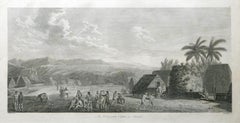
A View of the Ewharrano Eatua, or House of God, in Huahine from Cook's Voyages
$113.21
$141.5220% Off
£84.74
£105.9320% Off
€96
€12020% Off
CA$155.81
CA$194.7720% Off
A$173.67
A$217.0920% Off
CHF 91.12
CHF 113.9020% Off
MX$2,120.81
MX$2,651.0120% Off
NOK 1,153.77
NOK 1,442.2120% Off
SEK 1,090.49
SEK 1,363.1120% Off
DKK 730.82
DKK 913.5220% Off
About the Item
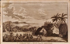
Title: "A View in the Island of Huaheine with Representations of the Ewharrano Eatua or House of God"
Description: This engraving, drawn from the 1784-86 publication "A New, Authentic, and Complete Account of Voyages Round the World" by Captain James Cook and George William Anderson, presents a scene from the island of Huahine in the Society Islands, visited during Cook’s voyages. The image highlights the Ewharrano Eatua, described as a "House of God," alongside a small altar with offerings. The scene offers a glimpse into Polynesian religious architecture and landscape, framed by tropical vegetation including the **Owharra** tree, which is used to thatch the houses.
Context: The print originates from the comprehensive account of Captain Cook’s voyages, published by George William Anderson between 1784 and 1786. This publication was meant to offer a full historical account of Cook's explorations, providing European readers with descriptions and illustrations of the places and peoples encountered. The voyages of Captain Cook were significant in expanding European knowledge of the Pacific, and these engravings contributed to shaping the public’s perception of these distant cultures.
Significance: This engraving, like others in Anderson’s work, served to inform and entertain readers about the exotic and unfamiliar lands that Cook encountered. The House of God depicted in the image may represent a sacred or ceremonial site for the islanders, and its inclusion demonstrates the European interest in understanding the spiritual practices of Indigenous peoples, although often through a European lens.
Interesting Aspects:
- The setting in Huahine emphasizes the lush tropical environment, with carefully drawn details of the local flora, particularly the Owharra tree.
- The architectural representation of the Ewharrano Eatua demonstrates the European attempt to document Polynesian structures, though interpretations of their purpose or construction were often filtered through a lack of deeper cultural understanding.
- The engraving was included in a work that not only documented voyages but also served as a tool of imperial expansion, reflecting the broader aims of European exploration during the period.
This scene is a visual documentation of the cross-cultural encounters that were a hallmark of Cook’s Pacific explorations and offers insight into how European publications represented Indigenous practices to a European audience during the 18th century.
- Dimensions:Height: 9.65 in (24.5 cm)Width: 15.16 in (38.5 cm)Depth: 0 in (0.02 mm)
- Materials and Techniques:Paper,Engraved
- Period:1780-1789
- Date of Manufacture:circa 1785
- Condition:Condition: fair, given age. With soiling and some foxing. General age-related toning and/or occasional minor defects from handling. Study images carefully.
- Seller Location:Langweer, NL
- Reference Number:Seller: BG-13597-501stDibs: LU3054341692592
About the Seller
5.0
Recognized Seller
These prestigious sellers are industry leaders and represent the highest echelon for item quality and design.
Platinum Seller
Premium sellers with a 4.7+ rating and 24-hour response times
Established in 2009
1stDibs seller since 2017
2,517 sales on 1stDibs
Typical response time: <1 hour
- ShippingRetrieving quote...Shipping from: Langweer, Netherlands
- Return Policy
Authenticity Guarantee
In the unlikely event there’s an issue with an item’s authenticity, contact us within 1 year for a full refund. DetailsMoney-Back Guarantee
If your item is not as described, is damaged in transit, or does not arrive, contact us within 7 days for a full refund. Details24-Hour Cancellation
You have a 24-hour grace period in which to reconsider your purchase, with no questions asked.Vetted Professional Sellers
Our world-class sellers must adhere to strict standards for service and quality, maintaining the integrity of our listings.Price-Match Guarantee
If you find that a seller listed the same item for a lower price elsewhere, we’ll match it.Trusted Global Delivery
Our best-in-class carrier network provides specialized shipping options worldwide, including custom delivery.More From This Seller
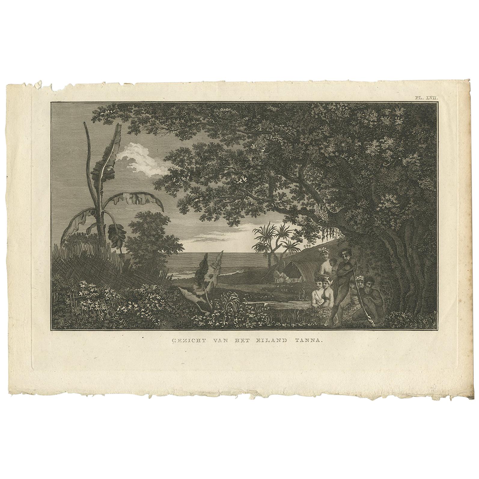
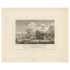
View AllView of Tanna Island: A Glimpse into Vanuatu from Cook's Voyages, 1803
Located in Langweer, NL
Antique print titled 'Gezicht van het Eiland Tanna'. This print depicts a view of Tanna Island, Vanuatu. Originates from 'Reizen rondom de Waereld' by J. Cook. Translated by J.D. Pas...
Category
Antique Early 19th Century Dutch Prints
Materials
Paper

$235 Sale Price
20% Off
Free Shipping
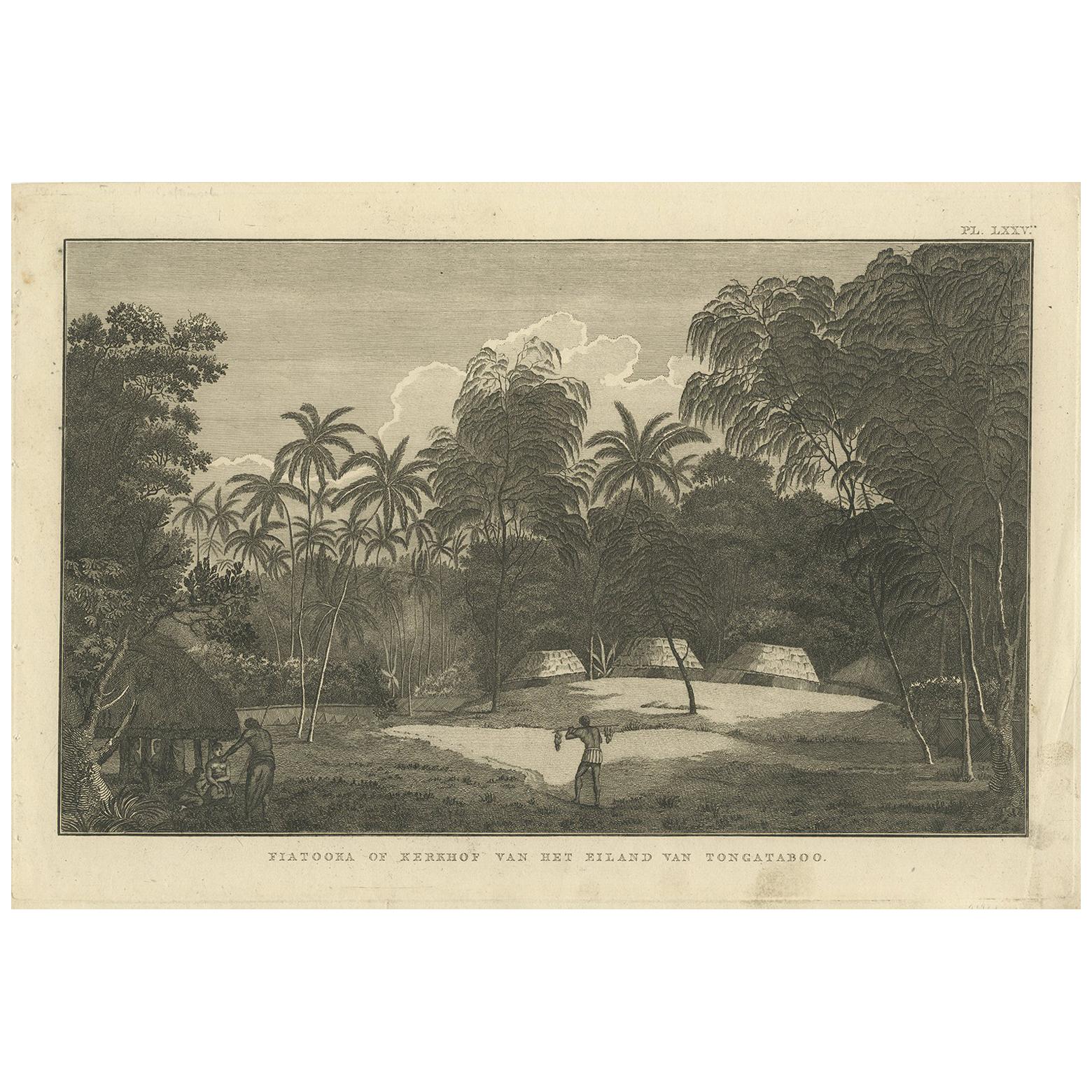
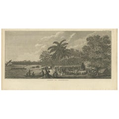
Antique Print of the Cemetery on the Island Tongatapu by Cook, circa 1801
Located in Langweer, NL
Antique print titled 'Fiatooka of Kerkhof van het Eiland van Tongataboo'. This print depicts a cemetery on the Island of Tongatapu. Originates from 'Reizen rondom de Waereld' by J. C...
Category
Antique Early 19th Century Prints
Materials
Paper
$113 Sale Price
20% Off
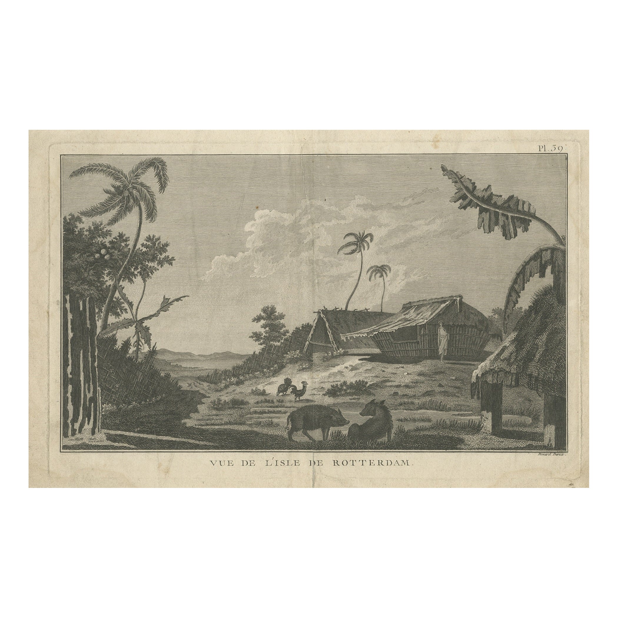
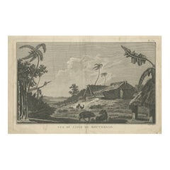
Antique Print of Rotterdam Island, Nomuka, Tonga
Located in Langweer, NL
Antique print titled 'Vue de l'Isle de Rotterdam'. Antique engraving of Rotterdam Island (Nomuka Island) in the Ha?apai group of islands in the Kingdom of Tonga as seen by Captain Co...
Category
Antique Late 18th Century Prints
Materials
Paper
$245 Sale Price
20% Off
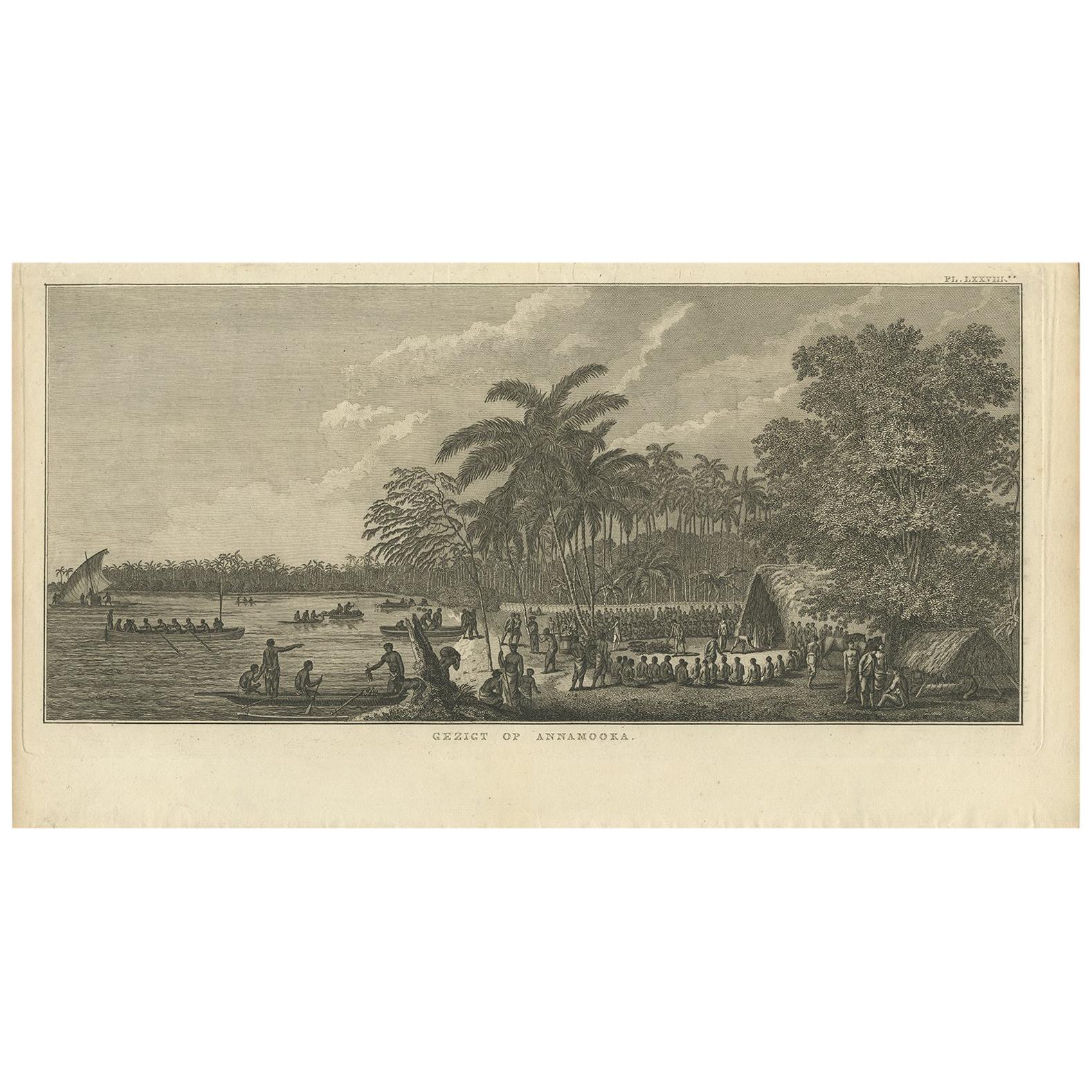
Antique Print of Annamooka, Tonga Islands, by Cook '1803'
Located in Langweer, NL
Antique print titled 'Gezigt op Annamooka'. This print depicts the Harbour of Annamooka, now Nomuka, part of the Ha’apai group of Tonga. Originates from 'Reizen rondom de Waereld' by...
Category
Antique Early 19th Century Dutch Prints
Materials
Paper
$353 Sale Price
20% Off
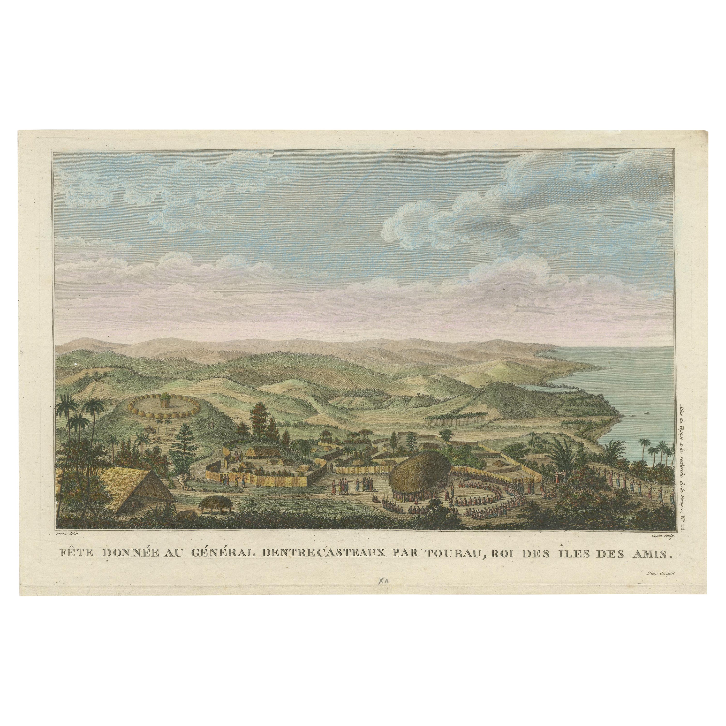
Beautiful and Rare Original Antique Engraving of a Village in Tonga, 1817
Located in Langweer, NL
Fete donnee au General Dentrecasteaux par Toubau, Roi des Iles des Amis
Original antique engraving showing the party given to General Dentrecasteaux by Toubau, King of the Friendl...
Category
Antique 1810s Prints
Materials
Paper

$603 Sale Price
20% Off
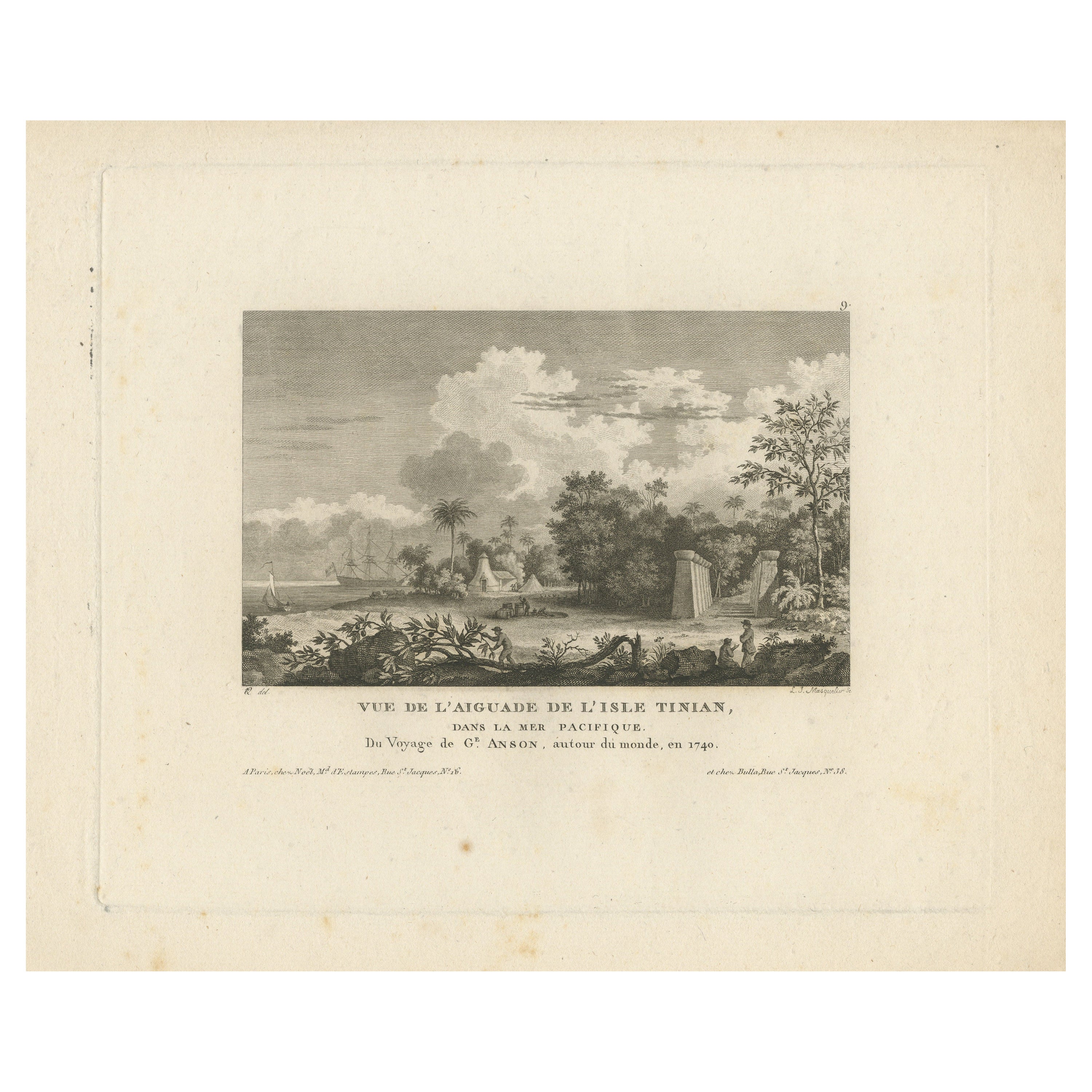
Antique Print of Tinian Island, Part of the Northern Mariana Islands
Located in Langweer, NL
Antique print titled 'Vue de l'Aiguade de l'isle Tinian.View of Tinian recorded during the journey of Lord George Anson, Mariana Islands. This print originates from 'Morgenblatt für ...
Category
Antique Mid-19th Century Prints
Materials
Paper
$301 Sale Price
20% Off
You May Also Like
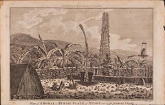
A View of Kauai, Hawaii Discovered by Captain Cook: Original 18th C. Engraving
By John Webber
Located in Alamo, CA
"View of A Morai or Burial Place of Atooi, One of the Sandwich Islands (Kauai, Hawaii)" is an original 18th century engraving from a drawing by John Webber (1751-1793), who was the a...
Category
1780s Landscape Prints
Materials
Engraving
A View of Kauai, Hawaii as Seen by Captain Cook: An Original 18th C. Engraving
By John Webber
Located in Alamo, CA
"An Inland View in Atooi, One of the Sandwich Islands (Kauai, Hawaii)" is an original 18th century engraving from a drawing by John Webber (1751-1793), who was the artist who accompa...
Category
1780s Landscape Prints
Materials
Engraving
Ancient View of Bombay - Original Lithograph - Half of the 19th Century
Located in Roma, IT
Ancient View of Bombay is an original modern artwork realized in the first half of the 19th Century.
Original B/W Lithograph on Ivory Paper.
Inscripted on the lower margin in Cap...
Category
Early 19th Century Modern Landscape Prints
Materials
Lithograph

Ancient View of Batavia - Original Lithograph - Half of the 19th Century
Located in Roma, IT
Ancient View of Batavia is an original modern artwork realized in the first half of the 19th Century.
Original B/W Lithograph on Ivory Paper.
Inscripted on the lower margin in Ca...
Category
Early 19th Century Modern Landscape Prints
Materials
Lithograph
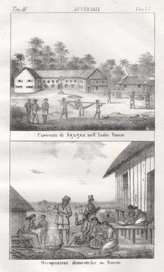
Guam, Convent and native inhabitants, mid 19th century lithograph. Oceania.
Located in Melbourne, Victoria
'Convento di agagna nell' Isola Guam. Occupazioni domestiche in Guam.'
Italian lithograph, c1841. Originally from 'Galleria universale di tutti i popoli del mondo' by Giuseppe Anton...
Category
Mid-19th Century Naturalistic Figurative Prints
Materials
Lithograph
An Inland View; in Atooi ( Hawaii ) 1784 Captain Cook engraving by John Webber
By John Webber
Located in Paonia, CO
An Inland View in Atooi ( Hawaii ) is from the 1784 First Edition Atlas Accompanying Capt. James Cook and King; Third and Final Voyage of Captain James Cook. This engraving depicts ...
Category
1780s Realist Landscape Prints
Materials
Engraving