Items Similar to Kamtschatka, Russia: Engraving by J. Webber from Capt. Cook's 3rd Voyage Journal

Want more images or videos?
Request additional images or videos from the seller
1 of 9
John WebberKamtschatka, Russia: Engraving by J. Webber from Capt. Cook's 3rd Voyage Journal1784
1784
$780
$97520% Off
£601.28
£751.6120% Off
€683.44
€854.2920% Off
CA$1,111.39
CA$1,389.2320% Off
A$1,209.07
A$1,511.3420% Off
CHF 638.01
CHF 797.5120% Off
MX$14,541.18
MX$18,176.4820% Off
NOK 8,048.24
NOK 10,060.3020% Off
SEK 7,490.16
SEK 9,362.7020% Off
DKK 5,104.15
DKK 6,380.1820% Off
About the Item
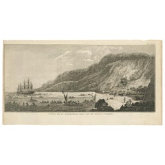
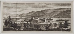
"A View of the Town and Harbour of St Peter and St Paul, in Kamtschatka" is an engraving created by Charles Grignion, from a drawing by John Webber (1752-1793), who was the artist on Captain James Cook's 3rd and final voyage of discovery. It is Plate 74 in the atlas of "A Voyage to the Pacific Ocean Undertaken by the Command of His Majesty, for Making Discoveries in the Northern Hemisphere", the official British Admirality sanctioned journal published upon completion of the voyage in London in 1784 by Strahan & Cadell. This rare engraving from the official British Admiralty sanctioned edition of the accounts of Cook’s third and final voyage is distinguished from all other later unauthorized copies from other publishers, which were often smaller and inferior in the quality of the engraving and the paper.
This original 18th century engraving from Captain Cook's 3rd voyage journal is printed on laid, chain-linked, watermarked paper. The sheet measures 15.75" high and 21.88" wide. It is in very good to excellent condition.
Reference: Beddie 1743-74, p.343, Joppien 3.328A, ill.p.556
Kamtschatka is a district and a peninsula in the asiatic part of Russia. The perspective of this view is towards the entrance of Avacha Bay with Captain Cook's ships, Discovery and Resolution, at anchor in the bay. The village is shown on the sandy peninsula with Kamchatkan summer huts and Russian log huts. Native inhabitants are seen at work around the village and in canoes in the foreground, presumably fishing. A man and woman are depicted on the far left dressed in their native garb. A snow-covered mountain is seen in the distance.
This is a description of the village in Cook's journal: "The Town or Ostrog of St. Peter & Paul stands upon a long narrow spit of Sand, which forms & seperates the Harbour from the Bay of Awatschka except at a narrow entrance about a Stones throw across. it consists of 5 or six Russian log Houses and about 15 Kamtschdale Houses called Balagans & 3 or 4 Joorta's."
It was at this village of St Peter and St Paul that the battered ships landed in late April 1779, after the death of Captain Cook in Hawaii. Here is where Major Behm agreed to take the news of Cook's death overland to St. Petersburg to then be relayed the England. Modern day Petropavlovsk-Kamchatsky is now a major commercial port and the home of Russia's nuclear submarine fleet.
Hawaii was discovered by Captain Cook (1728-1779) during this voyage. Hawaii was originally called The Sandwich Islands in honor of The Earl of Sandwich who, as head of the British Admiralty, authorized the funds necessary to finance the voyage. Captain Cook was killed by natives in Kealakekua Bay on the big island of Hawaii in 1779. His ships the Resolution and Discovery then returned to England. Other notables who were part of this expedition included Captain William Bligh, Cook's sailing master, who would later go down in history as captain of the mutinous crew of the Bounty and George Vancouver who would later explore and chart North America's northwestern Pacific Coast regions, including the coasts of Alaska, Washington, and Oregon, as well as the province of British Columbia in Canada. Vancouver Island and the city of Vancouver, British Columbia are named for him, as is Vancouver, Washington.
- Creator:John Webber (1751 - 1793, British)
- Creation Year:1784
- Dimensions:Height: 15.75 in (40.01 cm)Width: 21.88 in (55.58 cm)
- Medium:
- Period:1780-1789
- Framing:Framing Options Available
- Condition:
- Gallery Location:Alamo, CA
- Reference Number:Seller: # 45131stDibs: LU1173214672032
John Webber
John Webber (1751-1793) was recommended to the Admiralty for appointment as artist for the Captain Cook's 3rd voyage by the Swedish botanist Daniel Carlsson Solander (1733-1782) who had accompanied Cook on his first voyage. Just 24 years old when he joined the Captain Cook’s ship the Resolution at Plymouth one week prior to departure, Webber's skill in both portraiture and landscape resulted in a visual record of Cook's third voyage that is unsurpassed in the annals of 18th century exploration.
About the Seller
5.0
Platinum Seller
Premium sellers with a 4.7+ rating and 24-hour response times
Established in 2011
1stDibs seller since 2019
298 sales on 1stDibs
Typical response time: 1 hour
- ShippingRetrieving quote...Shipping from: Alamo, CA
- Return Policy
More From This Seller
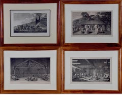
View AllFour Koa Wood Framed 18th C. Engravings from Captain Cook's 3rd Voyage Journal
By John Webber
Located in Alamo, CA
A grouping of four framed engravings of Hawaii, Tahiti, Tonga and Vancouver Island from the atlas of the official British Admiralty sanctioned journal of Captain Cook's 3rd Voyage entitled "A Voyage to the Pacific Ocean Undertaken by the Command of His Majesty, for Making Discoveries in the Northern Hemisphere", published upon completion of the voyage in London in 1784 by Strahan & Cadell. These engravings were made from drawings by John Webber (1752-1793), who was the artist on Captain James Cook's 3rd and final voyage of discovery. The set of engravings includes: "A Canoe of the Sandwich Islands, the Rowers Masked", Plate 65 in the atlas; "A Dance in Otaheite" (Tahiti), Plate 28; "King of the Friendly Islands" (Tonga), plate 20; "Inside of a House in Nootka Sound" (Canada), plate 42.
These engravings are professionally framed in Koa wood, the same wood as was used to make the canoes of the ancient Hawaiians. Koa wood is legendary in Hawaii. Not only is this amazing wood native to Hawaii, but it is known for the deep rich colors and varied grain pattern. Koa has an honored heritage in Hawaii and is highly revered and sacred. The word “koa” means “warrior” in Hawaiian. The warriors of King Kamehameha the Great, created canoes and weapons from a wood plentiful on the Big Island of Hawaii. This wood became synonymous with the warriors themselves, and it became known as koa.
These four engravings would make a wonderful grouping for a display of 2, 3 or 4 prints. They may be purchased separately or in groups on 1stDibs. Their listing Reference #'s are: LU117324682432, LU117324682022, LU117324684052 and LU117324684062. A discount is available for a grouping depending on the number of items included.
Hawaii was discovered by Captain Cook (1728-1779) during this voyage. Hawaii was originally called The Sandwich Islands in honor of The Earl of Sandwich...
Category
1780s Other Art Style Landscape Prints
Materials
Engraving
$7,660 Sale Price
20% Off
A View of Kauai, Hawaii Discovered by Captain Cook: Original 18th C. Engraving
By John Webber
Located in Alamo, CA
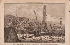
"View of A Morai or Burial Place of Atooi, One of the Sandwich Islands (Kauai, Hawaii)" is an original 18th century engraving from a drawing by John Webber (1751-1793), who was the a...
Category
1780s Landscape Prints
Materials
Engraving
Sandwich Islands Canoe (Hawaii): Framed 18th C. Engraving Captain Cook's Journal
By John Webber
Located in Alamo, CA
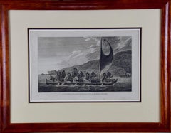
"A Canoe of the Sandwich Islands, the Rowers Masked" is an engraving created by Charles Grignion, from a drawing by John Webber (1752-1793), who was the artist on Captain James Cook's 3rd and final voyage of discovery. It is Plate 65 in the atlas of "A Voyage to the Pacific Ocean Undertaken by the Command of His Majesty, for Making Discoveries in the Northern Hemisphere", the official British Admiralty sanctioned journal published upon completion of the voyage in London in 1784 by Strahan & Cadell.
This famous image of ten Hawaiian rowers transporting a priest who is carrying a feather-covered image of Kukailimoku, the Hawaiian god of war. The priests and paddlers are all wearing gourd masks in their double-hulled canoe with an upright lateen woven sail. Each hull was shaped from a single large Koa log harvested from island rainforests, where they were carved before being transported to the coast.
This engraving is presented in a Koa wood frame and a white mat. There are occasional faint spots, but the print is otherwise in very good condition. Koa is the same wood as was used to make the canoe. Koa wood is legendary in Hawaii. Not only is this amazing wood native to Hawaii, but it is known for the deep rich colors and varied grain pattern. Koa has an honored heritage in Hawaii and is highly revered and sacred. The word “koa” means “warrior” in Hawaiian. The warriors of King Kamehameha the Great, created canoes and weapons from a wood plentiful on the Big Island of Hawaii. This wood became synonymous with the warriors themselves, and it became known as koa. The frame measures 20.75" high, 26.75" wide and 0.88" deep.
There are three other engravings listed from the official journal of Captain Cook's 3rd voyage available that are presented in identical Koa wood frames and mat (LU117324682022, LU117324684052, LU117324684062). They would make a wonderful grouping for a display of 2, 3 or 4 prints. A discount is available for a grouping depending on the number of items included.
Hawaii was discovered by Captain Cook (1728-1779) during this voyage. Hawaii was originally called The Sandwich Islands in honor of The Earl of Sandwich...
Category
1780s Landscape Prints
Materials
Engraving
Siberia as Explored by Behring: Original 18th Century Hand-colored Map by Bowen
Located in Alamo, CA
This is an original 18th century hand-colored map entitled "An Exact Chart of all the Countries through which Capt. Behring Travelled from Tobolski, Capital of Siberia to the Country...
Category
Mid-18th Century Old Masters Landscape Prints
Materials
Engraving

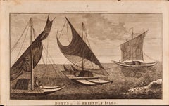
Boats of the Friendly Isles, Tonga: Original 18th C. Engraving from Captain Cook
By William Hodges
Located in Alamo, CA
"Boats of the Friendly Isles" is an original 18th century engraving from a drawing by William Hodges (1744-1797), who was the artist who accompanies Captain Cook on his second voyage...
Category
1780s Landscape Prints
Materials
Engraving
An Antique Engraved View of "Romelborg", Sweden in the 17th C. by Erik Dahlberg
By Erik Dahlberg
Located in Alamo, CA
An antique engraved view of "Romelborg", Sweden in 1705 from "Sueciae Antiquae et Hodiernae"' published in Stockholm by Erik Dahlberg (1625-1703). The engraving was created by Johan...
Category
Early 18th Century Naturalistic Landscape Prints
Materials
Laid Paper, Engraving
You May Also Like
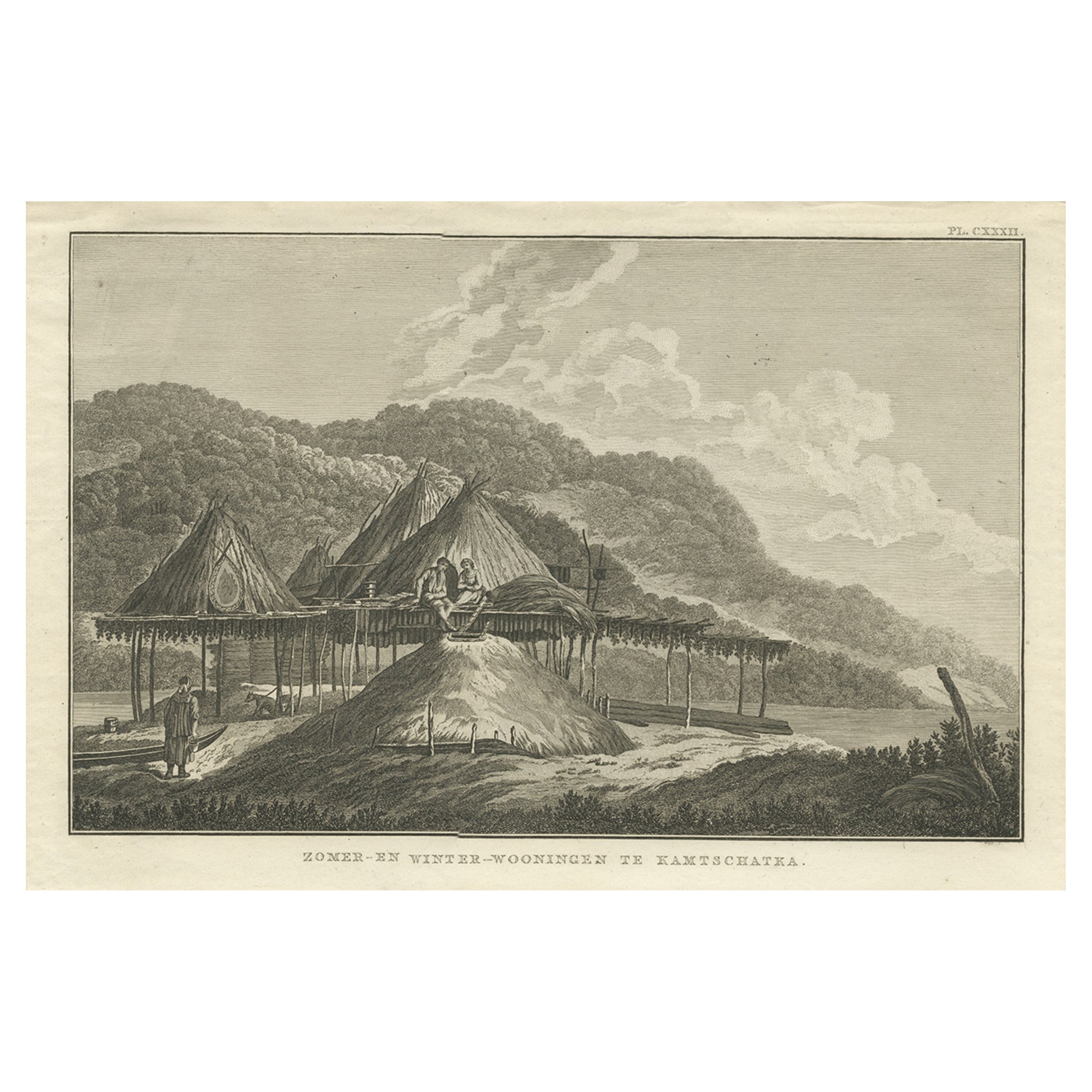
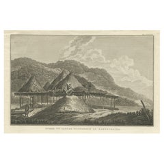
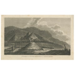
Summer & Winter Houses, Kamchatka – Cook Voyage Engraving c.1803
By James Cook
Located in Langweer, NL
This antique print depicts traditional summer and winter dwellings of the indigenous peoples of Kamchatka, Russia. The engraving shows a group of thatched structures set against a mo...
Category
Antique 19th Century Prints
Materials
Paper
$341 Sale Price
20% Off
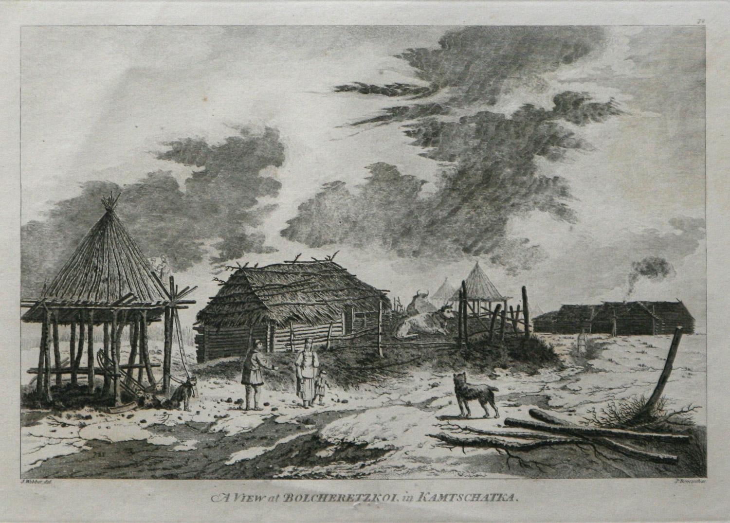
A View at Bolcheretzko (Russia) 1784 Captains Cook Final Voyage by John Webber
By John Webber
Located in Paonia, CO
A View at Bolcheretzko (Russia) is from the 1784 First Edition Atlas Accompanying Capt. James Cook and King; Third and Final Voyage of Captain James Cook.John Webber (1752-1793) was ...
Category
1780s Realist Landscape Prints
Materials
Engraving

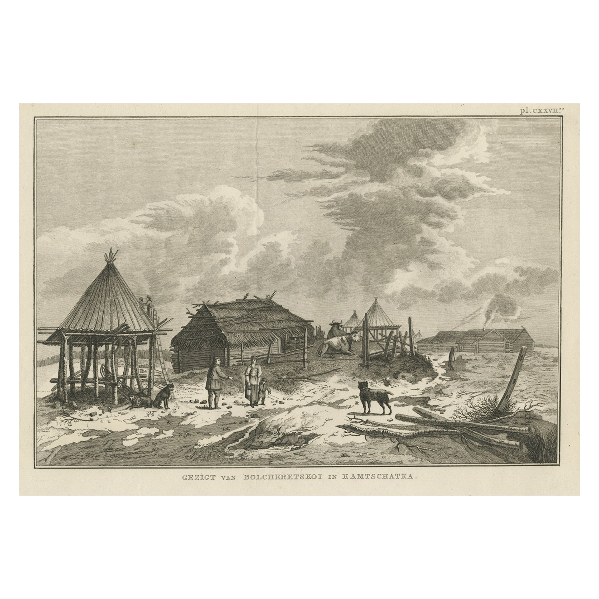
Antique Print of Bolcheretskoi in Kamchatka, Russia, 1803
By James Cook
Located in Langweer, NL
Antique print titled 'Gezigt van Bolcheretskoi in Kamtschatka'. Antique view of Bolcheretskoi in Kamchatka. Originates from 'Reizen Rondom de Waereld door James Cook (..)'.
Artis...
Category
Antique 19th Century Prints
Materials
Paper
$313 Sale Price
20% Off
Ancient View of Havannah - Original Lithograph - Early 19th Century
Located in Roma, IT
Ancient View of Havannah is an original modern artwork realized in the first half of the 19th Century.
Original Lithograph on Ivory Paper.
Inscripted in capital letters on the lo...
Category
Early 19th Century Modern Figurative Prints
Materials
Lithograph
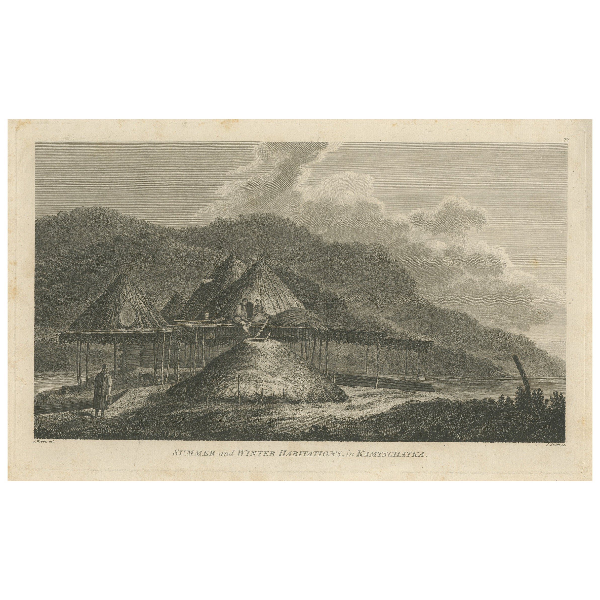
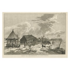
Antique Print of Summer and Winter Habitations in Kamchatka, Russia, 1784
Located in Langweer, NL
Experience Kamchatka: 'Summer and Winter Habitations' Print from Cook & King's Pacific Ocean Voyage
This antique print, titled 'Summer and Winter Habitations in Kamchatka,' offers a...
Category
Antique Late 18th Century Prints
Materials
Paper
$313 Sale Price
20% Off
Free Shipping
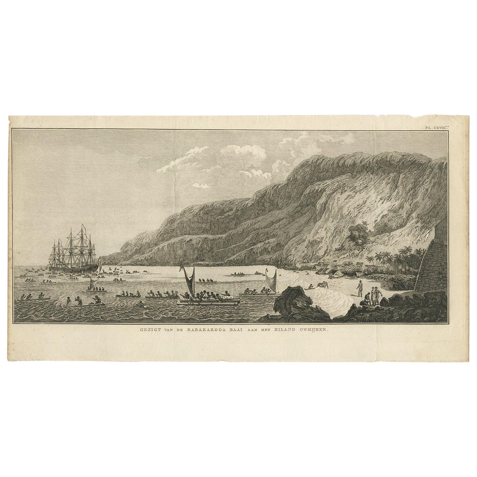
Antique Print of Karakakooa Bay by Cook, 1803
Located in Langweer, NL
Antique print titled 'Gezigt van de Karakakooa Baai aan het Eiland Owhijhee'. This print depicts Karakakooa Bay in Owyhee/Hawaï.
This engraving for sale depicts a scene of Karakako...
Category
Antique Early 19th Century Dutch Prints
Materials
Paper