Items Similar to Reception for Captain Cook, Tonga: Original 18th C. Engraving, Cook's 3rd Voyage

Want more images or videos?
Request additional images or videos from the seller
1 of 5
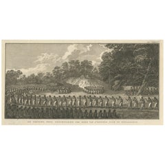
John WebberReception for Captain Cook, Tonga: Original 18th C. Engraving, Cook's 3rd Voyage1785
1785
$275
£209.77
€238.99
CA$386.51
A$421.68
CHF 223.28
MX$5,052.90
NOK 2,843.54
SEK 2,600.21
DKK 1,784.48
About the Item
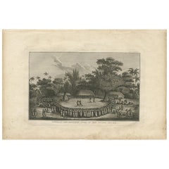
"The Reception of Capt. Cook in Hapaee" is an original 18th century engraving from a drawing by John Webber (1751-1793), who was the artist who accompanied Captain Cook on his third voyage of discovery, 1776-1780. The engraving appeared in Alexander Hogg's publication "A New, Authentic, and Complete Collection of Voyages Round the World" published in London in 1785.
This engraving depicts a large outdoor ceremony in Tonga to honor the visit by Captain Cook from May 1st to 14th, 1777. This is an unusual birds-eye view of a reception for Captain Cook at a Lifuka or Hapaee, Tonga featuring a ritual combat or fighting exhibition inside a ring lined by many Tongans and some of Cook's crew. Cook is reportedly seated between two chieftains inside a hut. There is a lush landscape in the background. The ceremony was witnessed by John Webber, the artist who accompanied Cook on his 3rd voyage of discovery. He made the drawing that was used for this 18th century engraving.
The engraving is printed on laid chain-linked paper. The sheet was created slightly wedge-shaped, measuring 9.63" in height on the left and 9.38" on the right. The sheet measures 15.25" in width. There are two short tears at the upper edge of the sheet which have been professionally stabilized on the verso, a short crease in the upper left corner and a tiny spot in the upper margin. The image is in excellent condition, beautifully inked.
Alexander Hogg was an 18th and early 19th century publisher of illustrated books of architectural and historical prints, as well as maps. His publishing house was located in London at the Kings Arms on Paternoster Row.
- Creator:John Webber (1751 - 1793, British)
- Creation Year:1785
- Dimensions:Height: 9.63 in (24.47 cm)Width: 15.25 in (38.74 cm)
- Medium:
- Period:1780-1789
- Framing:Framing Options Available
- Condition:
- Gallery Location:Alamo, CA
- Reference Number:Seller: # 10241stDibs: LU1173216422172
John Webber
John Webber (1751-1793) was recommended to the Admiralty for appointment as artist for the Captain Cook's 3rd voyage by the Swedish botanist Daniel Carlsson Solander (1733-1782) who had accompanied Cook on his first voyage. Just 24 years old when he joined the Captain Cook’s ship the Resolution at Plymouth one week prior to departure, Webber's skill in both portraiture and landscape resulted in a visual record of Cook's third voyage that is unsurpassed in the annals of 18th century exploration.
About the Seller
5.0
Platinum Seller
Premium sellers with a 4.7+ rating and 24-hour response times
Established in 2011
1stDibs seller since 2019
298 sales on 1stDibs
Typical response time: 1 hour
- ShippingRetrieving quote...Shipping from: Alamo, CA
- Return Policy
More From This Seller
View All"King of the Friendly Islands" (Tonga); Engraving from Captain Cook's 3rd Voyage
By John Webber
Located in Alamo, CA
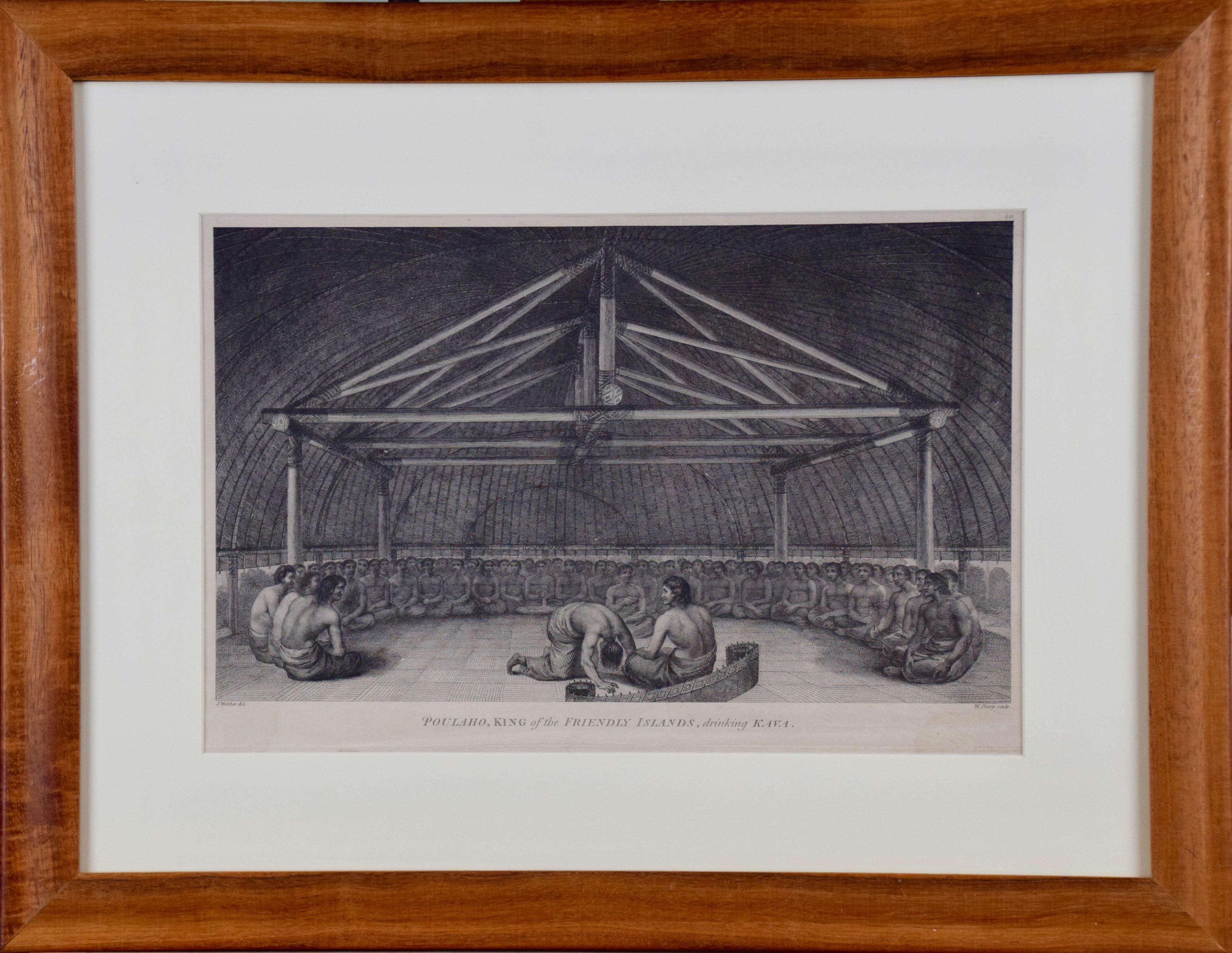
"Poulaho, King of the Friendly Islands, Drinking Kava" is an engraving created by William Sharp (1749-1824), from a drawing by John Webber (1752-1793), who was the artist on Captain James Cook's 3rd and final voyage of discovery. It was published in the atlas of "A Voyage to the Pacific Ocean Undertaken by the Command of His Majesty, for Making Discoveries in the Northern Hemisphere", the official British Admirality sanctioned journal published upon completion of the voyage in London in 1784 by Strahan & Cadell.
Captain Cook visited Tonga on his 3rd voyage, which he named The Friendly Islands because of the warm welcome he and his crew received, unlike some of the other more hostile Pacific islands. The engraving depicts Cook and his men observed a kava ceremony at the village of Mu’a on Tongatapu. King Paulaho sits in the centre foreground, his back to the spectator with a man kneeling before him. The ceremonial mat depicted behind Paulaho indicates that nobody was allowed to sit behind him. The figure in the centre holds a single cup, referring to the Tongan custom of offering the cup to the king first. Kava is native to the islands of the South Pacific and was first described for English readers in 1768 by Captain James Cook. The kava root has been used for centuries as a central feature of ceremonies and celebrations because it was able to bring about a calming and pleasant social atmosphere. The root was crushed and processed into coconut milk to become the focal ceremonial beverage, simply referred to as kava.
This engraving is presented in a Koa wood frame and a white mat. Koa wood is legendary in Hawaii. There are occasional faint spots, but the print is otherwise in very good condition. This amazing Koa wood is native to Hawaii and it is known for the deep rich colors and varied grain pattern. Koa has an honored heritage in Hawaii and is highly revered and sacred. The word “koa” means “warrior” in Hawaiian. The warriors of King Kamehameha the Great, created canoes and weapons from a wood plentiful on the Big Island of Hawaii. This wood became synonymous with the warriors themselves, and it became known as koa.
There are three other engravings listed from the official journal of Captain Cook's 3rd voyage available that are presented in identical Koa wood frames and mats (LU117324682422, LU117324684052, LU117324684032). They would make a wonderful grouping for a display of 2, 3 or 4 prints. A discount is available for a grouping depending on the number of items included.
Captain Cook is remembered as one of the greatest explorers and navigators in history. His explorations included Australia, New Zealand and islands of the South Pacific and the northwest coast of North America. Hawaii was discovered by Captain Cook during this voyage. Hawaii was originally called The Sandwich Islands in honor of The Earl of Sandwich...
Category
1780s Realist Figurative Prints
Materials
Engraving
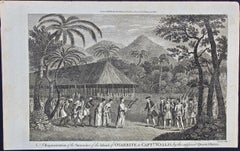
Surrender of Tahiti to Captain Wallis: An Original 18th C. Engraving
By John Webber
Located in Alamo, CA
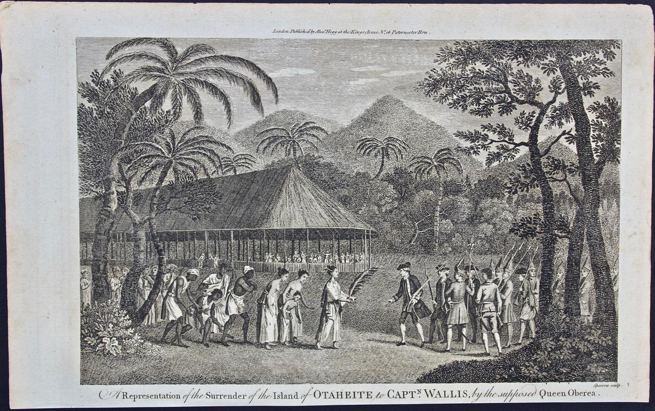
"A Representation of the Surrender of the Island of Otaheite to Capt.n Wallis, by the Supposed Queen of Oberea" is an original 18th century engraving created by Sparrow, from a drawi...
Category
1780s Landscape Prints
Materials
Engraving
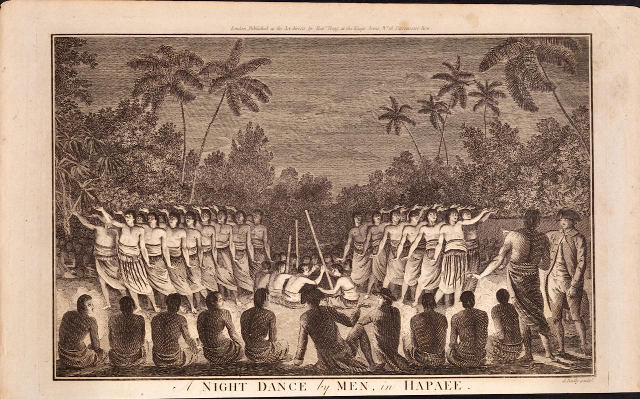
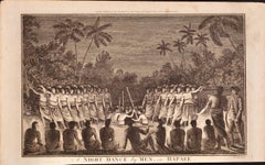
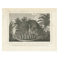
A Night Dance by Men in Tonga: An Original 18th C. Engraving, Cook's 3rd Voyage
By John Webber
Located in Alamo, CA
"A Night Dance by Men in Hapaee" is an original 18th century engraving from a drawing by John Webber (1751-1793), who was the artist who accompanied Captain Cook on his third voyage ...
Category
1780s Landscape Prints
Materials
Engraving
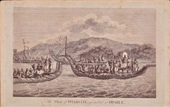
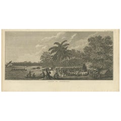
The Fleet of Tahiti displayed for Captain Cook: An Original 18th C. Engraving
By William Hodges
Located in Alamo, CA
"The Fleet of Otaheite, Assembled at Oparee" is an original 18th century engraving from a drawing by William Hodges (1744-1797), who was the artist who accompanies Captain Cook on hi...
Category
1780s Landscape Prints
Materials
Engraving
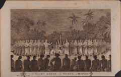
A Night Dance by Women in Tonga: Original 18th C. Engraving, Cook's 3rd Voyage
By John Webber
Located in Alamo, CA
"A Night Dance by Women in Hapaee" is an original 18th century engraving from a drawing by John Webber (1751-1793), who was the artist who accompanied Captain Cook on his third voyag...
Category
1780s Landscape Prints
Materials
Engraving
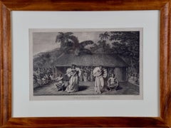
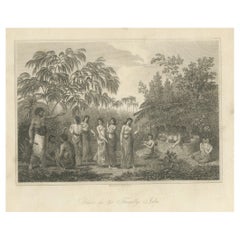
"A Dance in Otaheite" (Tahiti), Engraving from Captain Cook's 3rd Voyage
By John Webber
Located in Alamo, CA
"A Dance in Otaheite" (Tahiti) is an engraving created by William Sharp (1749-1824), from a drawing by John Webber (1752-1793), who was the artist on Captain James Cook's 3rd and final voyage of discovery. It is a plate in the atlas of "A Voyage to the Pacific Ocean Undertaken by the Command of His Majesty, for Making Discoveries in the Northern Hemisphere", the official British Admirality sanctioned journal published upon completion of the voyage in London in 1784 by Strahan & Cadell.
Two women and two men wearing ceremonial costumes, performing a dance outdoors standing on a mat. Three men are playing the drums in the background, in front of a thatched roof building. An audience of men are sitting on both sides of the stage. By the time Webber arrived in Tahiti, 'south sea' imagery had become familiar. Webber gave concentrated attention to dance. He had the opportunity to distinguish the Tahitian dance from the more formalized dancing of Tonga. Whereas they seem to have called to mind the more formal dances of antiquity, the Tahitian dancing aroused memories of peasant and folk dancing.
This engraving is professionally framed in Koa wood. Koa wood is legendary in Hawaii. Not only is this amazing wood native to Hawaii, but it is known for the deep rich colors and varied grain pattern. Koa has an honored heritage in Hawaii and is highly revered and sacred. The word “koa” means “warrior” in Hawaiian. The warriors of King Kamehameha the Great, created canoes and weapons from a wood plentiful on the Big Island of Hawaii. This wood became synonymous with the warriors themselves, and it became known as koa.
The print is in excellent condition.
There are three other engravings listed from the official journal of Captain Cook's 3rd voyage available that are presented in identical Koa wood frames and double mats (LU117324682432, LU117324684052, LU117324684062). They would make a wonderful grouping for a display of 2, 3 or 4 prints. A discount is available for a grouping depending on the number of items included.
Hawaii was discovered by Captain Cook during this voyage. Hawaii was originally called The Sandwich Islands in honor of The Earl of Sandwich...
Category
1780s Realist Landscape Prints
Materials
Engraving
You May Also Like
Antique Print of the Arrival of Captain Cook, 1803
Located in Langweer, NL
This antique print depicts the ceremonial welcome received by Captain James Cook upon his arrival at the island of Hapaee (Ha’apai) in Tonga during his third voyage in 1777. The engr...
Category
Antique Early 19th Century Dutch Prints
Materials
Paper
$191 Sale Price
20% Off
The Ceremonial Offering to Captain Cook in Hawaii, Engraved in 1778
Located in Langweer, NL
Title: "The Ceremonial Offering to Captain Cook in Hawaii, 1778"
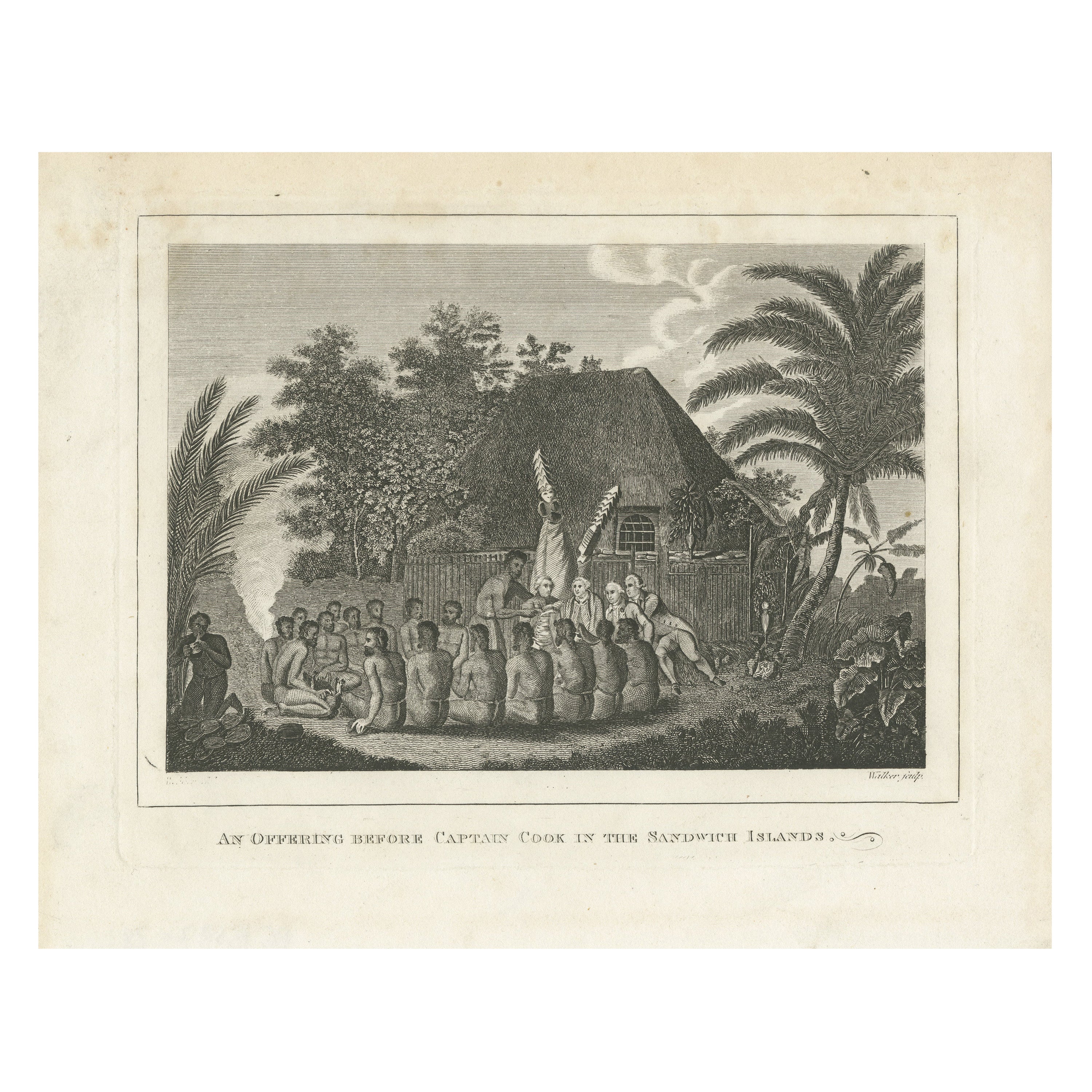
This detailed antique engraving, titled "An Offering Before Captain Cook in the Sandwich Islands," captures a significant historical encounter from Captain James Cook's voyages. The artwork, based on a drawing by John Webber, who accompanied Cook, was skillfully translated into print by the combined talents of Samuel Middiman for the landscape and John Hall for the figures. Created around 1778, this scene illustrates a moment where indigenous Hawaiian men present offerings of suckling pigs to Captain Cook and his European companions. A towering figure wearing an imposing mask stands sentinel behind the Europeans, symbolizing the cultural richness and ceremonial traditions of the Hawaiian people. The scene is framed by native palms and lush tropical vegetation, with a typical steep-roofed thatched building enclosed by a fence in the background, hinting at the architectural styles of the era. This print, marked by 'Walker sculp', offers a poignant visual narrative of cultural exchange in the age of exploration.
Category
Antique Late 18th Century Prints
Materials
Paper
$469 Sale Price
20% Off
Free Shipping
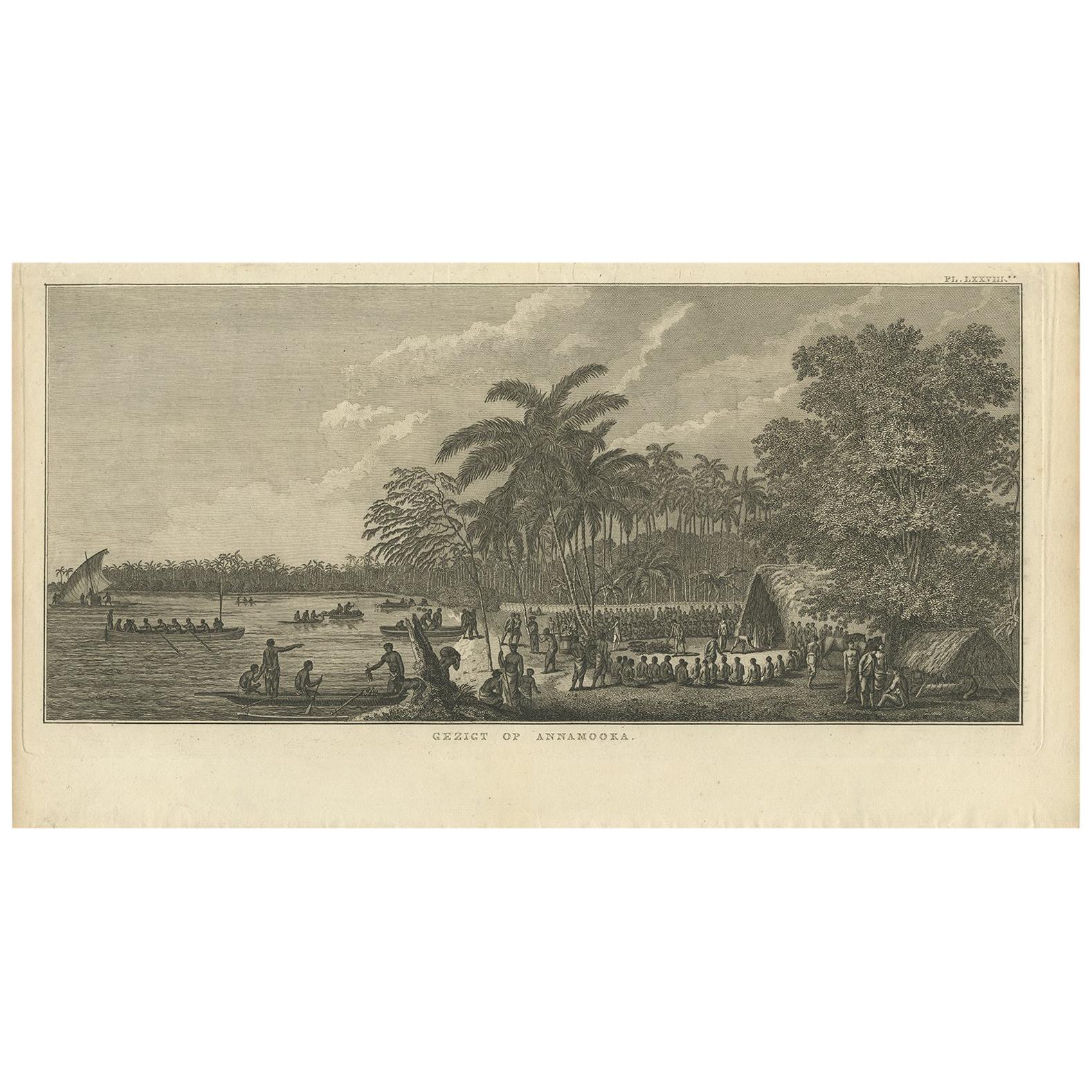
Antique Print of Annamooka, Tonga Islands, by Cook '1803'
Located in Langweer, NL
Antique print titled 'Gezigt op Annamooka'. This print depicts the Harbour of Annamooka, now Nomuka, part of the Ha’apai group of Tonga. Originates from 'Reizen rondom de Waereld' by...
Category
Antique Early 19th Century Dutch Prints
Materials
Paper
Rhythms of the Pacific: A Communal Dance in Tonga, Engraving Published in 1812
Located in Langweer, NL
The engraving depicts a serene and communal scene labeled as "Dance in the Friendly Isles." The Friendly Isles is an older name for the Kingdom of Tonga in the South Pacific. This pi...
Category
Antique Early 19th Century Prints
Materials
Paper
$249 Sale Price
20% Off
Free Shipping
De Natsche – Ceremony for the King's Son, Tonga c.1795
Located in Langweer, NL
De Natsche – Ceremony for the King's Son, Tonga c.1795
This antique print depicts a grand ceremony held in honour of the son of the King of Tonga, known as the Natsche, in the villa...
Category
Antique Early 1800s European Prints
Materials
Paper
$565 Sale Price
20% Off
Divine Honors Bestowed Upon Captain Cook: A Ceremonial Encounter, circa 1820
Located in Langweer, NL
This is an antique print titled "Onori divini fatti a Cook," which translates to "Divine honors given to Cook." It likely depicts a moment when Captain James Cook, the famed British ...
Category
Antique Early 19th Century Prints
Materials
Paper
$191 Sale Price
20% Off