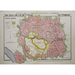
Items Similar to 1947 original map "Les eaux-de-vie de France - Le Cognac Bons Bois" by Larmat


Want more images or videos?
Request additional images or videos from the seller
1 of 8
Louis Larmat1947 original map "Les eaux-de-vie de France - Le Cognac Bons Bois" by Larmat1947
1947
$1,188.63
£885.16
€1,000
CA$1,641.06
A$1,819.36
CHF 956.14
MX$22,265.95
NOK 11,941.26
SEK 11,208.07
DKK 7,613.67
About the Item
The 1947 original map Atlas de la France Vinicole - Les Eaux-de-vie de France - Le Cognac Bons Bois, created by Louis Larmat and printed by Dorel in Paris, is a beautifully crafted cartographic depiction of one of the lesser-known but important Cognac crus, Bons Bois. This map is part of Larmat’s highly regarded Atlas de la France Vinicole series, which meticulously charts France’s wine and spirit-producing regions with a perfect balance of artistic beauty and scientific precision. The Bons Bois region, like other Cognac areas, plays a crucial role in the production of this world-renowned spirit, making Larmat’s map both a practical resource and a treasured collectible.
Louis Larmat was a renowned French cartographer who dedicated his career to mapping the vinicultural regions of France, creating works that have become benchmarks for their accuracy, detail, and visual appeal. His Atlas de la France Vinicole series is notable for the way it documents France’s wine and spirit production zones, showing the geographical, climatic, and environmental factors that shape the character of these products. The map of Bons Bois captures the essence of this Cognac cru, giving both a clear geographical outline and insights into the region’s role within the broader Cognac production area.
Bons Bois is one of the six official Cognac crus, and it is known for its large surface area, extending far beyond the heartland regions of Cognac. This region surrounds the more prestigious crus of Grande Champagne and Petite Champagne and stretches out toward the coast. The size of Bons Bois means that its terroir is more diverse, encompassing a variety of soils and microclimates. These differences result in Cognacs with distinctive characteristics, often more rustic and quicker to mature than those from the central Cognac-producing areas. Larmat’s map of Bons Bois offers a detailed depiction of the region’s boundaries, illustrating its size and proximity to other Cognac-producing areas like Fins Bois and Bois Ordinaires.
The map showcases the key geographical features that define Bons Bois, including its rivers, towns, and other landmarks. Larmat pays particular attention to the topography and soil composition, as these are critical factors in Cognac production. The Bons Bois region’s soils tend to be more varied than those found in the central Cognac regions, with a mix of chalk, clay, and sand. This diversity is reflected in the types of eaux-de-vie produced here, which tend to have robust, fruity flavors with more pronounced earthy notes, compared to the more delicate profiles of Cognacs from Grande Champagne or Petite Champagne.
One of the most notable aspects of Larmat’s map is its hand-colored detailing, which adds a vibrant and artistic dimension to the cartography. The use of color helps to distinguish the boundaries of Bons Bois from adjacent Cognac regions and highlights the region’s key features. The careful attention to shading and the use of decorative elements such as grapevines and barrels emphasize the artisanal nature of Cognac production and the cultural significance of the terroir. This map, like others in the Atlas de la France Vinicole series, is not just a functional tool but also a work of art, valued for its aesthetic qualities as well as its cartographic accuracy.
Larmat includes annotations on the map that describe the characteristics of the eaux-de-vie produced in the Bons Bois region. These notes explain that Cognac from Bons Bois is typically robust, with faster maturation times, making it suitable for blends that require body and strength. The flavors are often more rustic, with fruit-forward notes, particularly of apples and pears, and hints of earthiness and wood. These eaux-de-vie are frequently blended with those from other regions to create well-rounded Cognacs that combine the finesse of the central crus with the power and structure of Bons Bois. Larmat’s detailed descriptions would have been invaluable to merchants, producers, and educators looking to understand the unique contributions of each Cognac-producing area.
The map is framed by elegant typography and subtle decorative borders that enhance its visual appeal. The title, rendered in bold, clear lettering, ensures that the map’s purpose is immediately identifiable, while the surrounding flourishes, often featuring motifs related to Cognac production, add a sense of tradition and craftsmanship. These artistic touches reflect the deep connection between French culture and its renowned culinary and agricultural products, particularly in regions like Cognac where terroir plays such a significant role in the final product. Larmat’s maps celebrate this heritage, making them not only informative but also culturally resonant.
In the post-war context of 1947, when this map was created, there was a renewed focus on re-establishing France’s dominance in the global wine and spirits market. Cognac, with its long history and international prestige, was a key part of this resurgence. The maps in Larmat’s Atlas de la France Vinicole played a role in promoting the uniqueness of France’s viticultural regions, showcasing the geographical and environmental factors that contribute to the country’s superior wine and spirit production. The Bons Bois map, with its careful attention to the region’s specific characteristics, reflects this broader effort to highlight the quality and diversity of French terroirs.
Today, Larmat’s 1947 map of Bons Bois is a highly sought-after collectible, prized by both map enthusiasts and those with an interest in Cognac and French viniculture. Its combination of artistic beauty and scientific accuracy makes it a valuable artifact, whether displayed as a decorative piece or studied for its geographical insights. For connoisseurs of Cognac, the map serves as a reminder of the importance of terroir in the creation of fine spirits, and for historians, it provides a snapshot of how the Bons Bois region was understood and valued in the mid-20th century.
Larmat’s Atlas de la France Vinicole maps remain significant not only for their historical and educational value but also for their role in preserving and celebrating France’s cultural heritage. The Bons Bois map, with its detailed portrayal of one of the key Cognac-producing regions, stands as a testament to the rich history and ongoing tradition of excellence in French spirit production. Through this map, Larmat has captured not only the geography of Bons Bois but also its place in the larger story of Cognac, offering a lasting tribute to the craftsmanship and expertise that define this iconic French product.
Original Poster
Alcohol - Map - Charente - France
Dorel - Paris
- Creator:Louis Larmat
- Creation Year:1947
- Dimensions:Height: 24.81 in (63 cm)Width: 17.72 in (45 cm)
- Medium:
- Period:
- Condition:Good condition, original folds.
- Gallery Location:PARIS, FR
- Reference Number:1stDibs: LU1792215285602
About the Seller
5.0
Gold Seller
Premium sellers maintaining a 4.3+ rating and 24-hour response times
Established in 2021
1stDibs seller since 2022
171 sales on 1stDibs
Typical response time: 1 hour
- ShippingRetrieving quote...Shipping from: PARIS, France
- Return Policy
Authenticity Guarantee
In the unlikely event there’s an issue with an item’s authenticity, contact us within 1 year for a full refund. DetailsMoney-Back Guarantee
If your item is not as described, is damaged in transit, or does not arrive, contact us within 7 days for a full refund. Details24-Hour Cancellation
You have a 24-hour grace period in which to reconsider your purchase, with no questions asked.Vetted Professional Sellers
Our world-class sellers must adhere to strict standards for service and quality, maintaining the integrity of our listings.Price-Match Guarantee
If you find that a seller listed the same item for a lower price elsewhere, we’ll match it.Trusted Global Delivery
Our best-in-class carrier network provides specialized shipping options worldwide, including custom delivery.More From This Seller
View All1947 original map "Les eaux-de-vie de France - Le Cognac fins bois" by Larmat
Located in PARIS, FR
The 1947 original map Atlas de la France Vinicole - Les Eaux-de-vie de France - Le Cognac Fins Bois, created by Louis Larmat and printed by Dorel in Paris, is an exquisite piece that...
Category
1940s Prints and Multiples
Materials
Lithograph, Paper
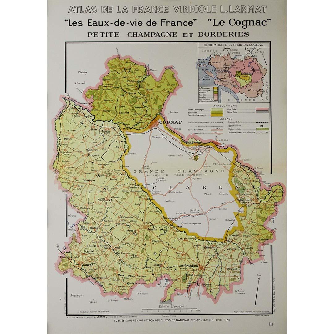
1947 original map "Les eaux-de-vie de France - Le Cognac petite Champagne"
Located in PARIS, FR
The 1947 original map Atlas de la France Vinicole - Les eaux-de-vie de France - Le Cognac Petite Champagne et Borderies, created by Louis Larmat and printed by Dorel in Paris, is a d...
Category
1940s Prints and Multiples
Materials
Lithograph, Paper
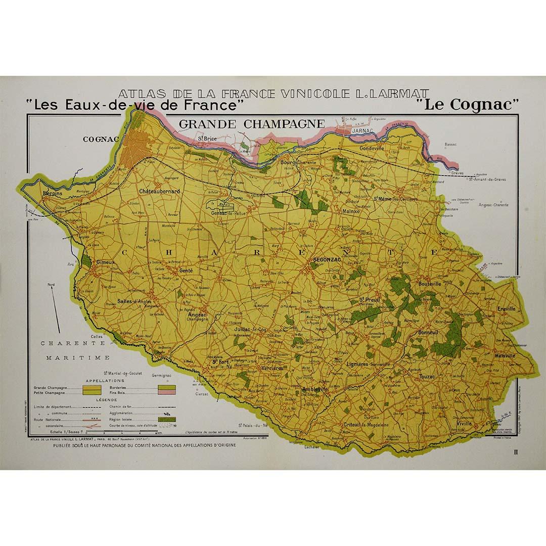
1947 original map "Les eaux-de-vie de France - Le Cognac" by Larmat
Located in PARIS, FR
The 1947 original map Atlas de la France vinicole - Les eaux-de-vie de France - Le Cognac, created by Louis Larmat and printed by Dorel in Paris, is a fascinating and detailed cartog...
Category
1940s Prints and Multiples
Materials
Lithograph, Paper
1947 original map "Le Cognac Bois ordinaires & Bois communs" by Larmat
Located in PARIS, FR
The 1947 original map Atlas de la France Vinicole - Les Eaux-de-vie de France - Le Cognac Bois Ordinaires & Bois Communs dits à Terroir, created by Louis Larmat and printed by Dorel ...
Category
1940s Prints and Multiples
Materials
Lithograph, Paper
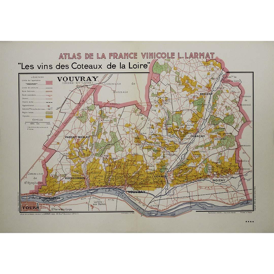
1946 original map "Les vins des côteaux de la Loire - Vouvray " by Larmat
Located in PARIS, FR
The 1946 map titled Atlas de la France Vinicole - Les Vins des Côteaux de la Loire: Vouvray by Louis Larmat, printed by Dorel in Paris, presents an intimate exploration of one of the...
Category
1940s Prints and Multiples
Materials
Lithograph, Paper

You May Also Like
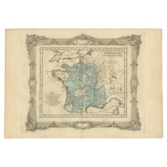
Antique Map of France by Johnston (1909)
Located in Langweer, NL
Antique map titled 'France'. Original antique map of France. With inset maps of France in provinces, part of the Riviera and Corsica. This map or...
Category
Early 20th Century Maps
Materials
Paper

$237 Sale Price
20% Off
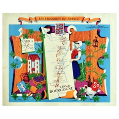
Original Vintage Poster Vignobles De France Vins De Bourgogne Burgundy Wine Map
Located in London, GB
Original vintage drink advertising poster promoting French wines (one of a series issued by the Comite National de Propagande en Faveur du Vin national committee for the promotion of...
Category
Vintage 1950s French Posters
Materials
Paper
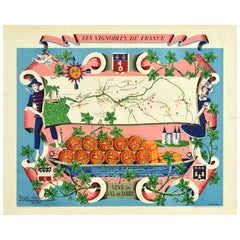
Original Vintage Poster Vignobles De France Vins Du Val De Loire Valley Wine Map
Located in London, GB
Original vintage drink advertising poster promoting French wines (one of a series issued by the Comite National de Propagande en Faveur du Vin national committee for the promotion of...
Category
Vintage 1950s French Posters
Materials
Paper
Antique Map of France under the Reign of Francois I, 1765
Located in Langweer, NL
Antique map France titled 'Etat des Possessions de la Couronne (..)'.
Beautiful old map of France. This map originates from 'Atlas Historique de la France Ancienne et Moderne' by...
Category
Antique 18th Century Maps
Materials
Paper
$140 Sale Price
20% Off
Antique Map of Vienne 'France' by V. Levasseur, 1854
By Victor Levasseur
Located in Langweer, NL
Antique map titled 'Dépt. de la Vienne'. Decorative antique map of the French Department of Vienne, with its capital of Poitiers and small engraved vignette of the battle of Poitiers...
Category
Antique Mid-19th Century Maps
Materials
Paper

$171 Sale Price
20% Off
Antique Map of France by Lapie, 1842
Located in Langweer, NL
Antique map titled 'Carte de France'. Map of France. This map originates from 'Atlas universel de géographie ancienne et moderne (..)' by Pierre M. Lapie and Alexandre E. Lapie. Pier...
Category
Antique Mid-19th Century Maps
Materials
Paper

$523 Sale Price
20% Off
More Ways To Browse
Bon Bon Vintage
Large Vintage Map
Used Wine Barrels
Vintage French Poster Wine
Treasure Map
Vintage Agricultural Poster
French Grande Poster
Vintage Alcohol Posters
French Poster Art Alcohol
Champagne Poster
Vintage Barrel Stand
Vintage Paris Map Framed
Wine Region Poster
French Champagne Posters
Cartographer Tool
Vintage Champagne Poster
Louis Cognac
Original Vintage Champagne Posters