Items Similar to 1947 original map "Les eaux-de-vie de France - Le Cognac" by Larmat


Want more images or videos?
Request additional images or videos from the seller
1 of 8
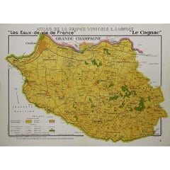
Louis Larmat1947 original map "Les eaux-de-vie de France - Le Cognac" by Larmat1947
1947
$1,186.58
£880.74
€1,000
CA$1,646.36
A$1,844.58
CHF 959.26
MX$22,348.51
NOK 12,221.44
SEK 11,409.14
DKK 7,614.09
About the Item
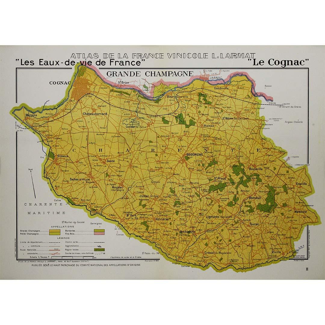
The 1947 original map Atlas de la France vinicole - Les eaux-de-vie de France - Le Cognac, created by Louis Larmat and printed by Dorel in Paris, is a fascinating and detailed cartographic representation of the Cognac-producing regions of France. This map is part of the larger Atlas de la France Vinicole, a highly regarded collection of maps that meticulously charted France's wine and spirit-producing areas during the mid-20th century. Larmat's work is celebrated for its precision, artistry, and its role in documenting the rich viticultural and spirit traditions of France, specifically Cognac, one of the country’s most famous and valuable exports.
Louis Larmat, a French cartographer, is best known for his Atlas de la France Vinicole series, which provides an exhaustive visual survey of France's wine and spirit regions. Published in the 1940s, these maps not only served as valuable references for professionals in the wine and spirits industry but also became treasured by collectors and connoisseurs for their artistic detail and historical significance. Larmat’s maps are often distinguished by their hand-colored accents and detailed annotations, which offer insights into the specific geographic characteristics that define France’s diverse wine and spirit appellations.
In the case of the Cognac region, Larmat’s 1947 map highlights the various terroirs and their contributions to the production of this world-renowned brandy, known for its exceptional quality and prestige.
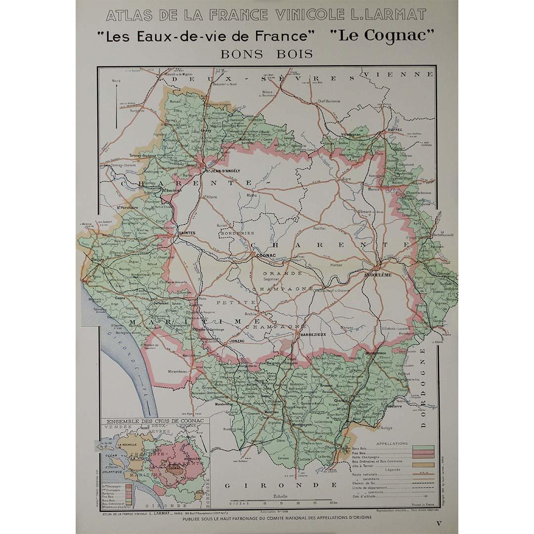
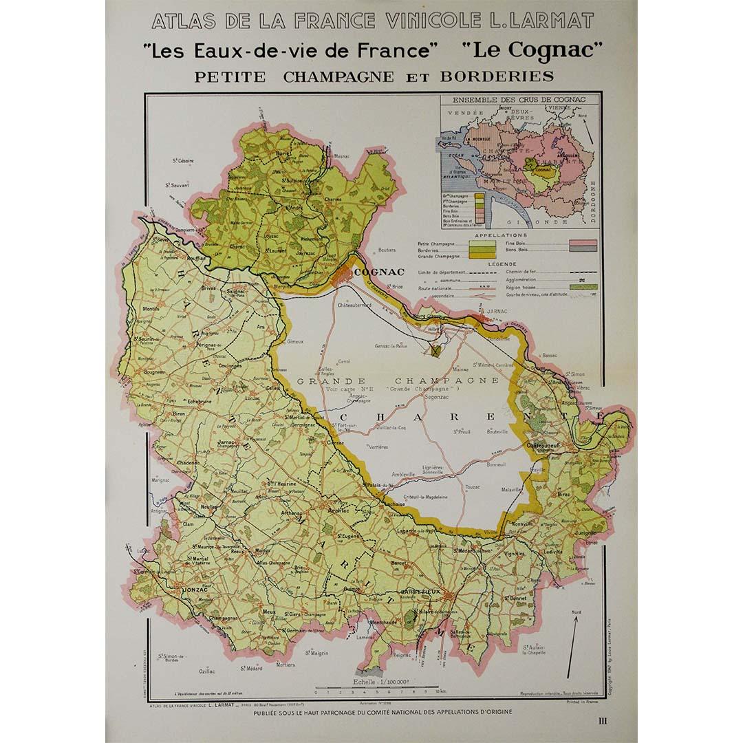
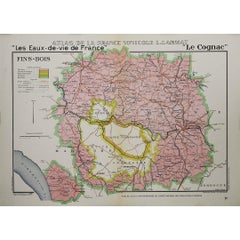
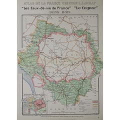
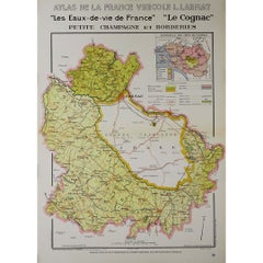
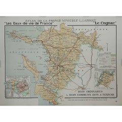
The Les eaux-de-vie de France - Le Cognac map is a masterful blend of cartography and vinicultural expertise. It provides a clear geographical layout of the Cognac-producing areas in western France, specifically in the departments of Charente and Charente-Maritime. The map carefully delineates the different zones that contribute to the production of Cognac, including the Grande Champagne, Petite Champagne, Borderies, Fins Bois, Bons Bois, and Bois Ordinaires. These regions, known as crus, are each labeled and color-coded, showcasing their role in creating Cognac with varying flavors, aromas, and aging potentials.
At the center of the map is a detailed layout of the region, showing rivers, towns, and vineyards, giving both geographic context and insight into how the terroir influences the final product. Cognac’s production relies heavily on its climate, soil, and topography, all of which are carefully outlined by Larmat, emphasizing the role of geography in crafting the spirit's unique characteristics.
In addition to the primary map, there are often insets that provide further details, such as information on the distillation process, aging methods, and classification of Cognac eaux-de-vie. These features make the map not only a cartographic piece but also an educational tool for understanding the complex journey from grape to bottle.
Louis Larmat’s maps are celebrated for their artistic quality, and the Le Cognac map is no exception. The hand-colored elements add a layer of vibrancy, with each cru in the Cognac region marked by distinct hues. These colors help to differentiate between the regions, making the map visually engaging and easy to interpret.
The typography used in Larmat’s maps is both elegant and functional, with regional names and place names clearly legible. There is often an ornamental title cartouche in maps of this period, which adds to the aesthetic appeal, combining practical information with artistic embellishment. The borders of the map are often decorated with grapevines, barrels, or other symbolic imagery that emphasizes the subject matter—Cognac production.
The map of the Cognac region published in 1947 came at an important time in the post-World War II period when France was re-establishing its cultural identity and reasserting its dominance in the world of luxury goods, including wine and spirits. The Cognac industry had suffered during the war, and this map can be seen as part of the broader effort to revive and promote France’s viticultural heritage. Cognac, which had long been one of France’s most prestigious spirits, regained its prominence during this period, and Larmat’s map served both practical and promotional purposes.
Maps such as Larmat’s were not only tools for producers and traders but also educational materials that helped the wider public understand the importance of terroir in the production of Cognac. The clear distinction between the different crus was crucial in demonstrating how geography affected the final product, reinforcing the idea that Cognac’s greatness was rooted in the land itself.
Today, original maps from Louis Larmat’s Atlas de la France Vinicole are highly sought after by collectors, historians, and enthusiasts of French wine and spirits. The Les eaux-de-vie de France - Le Cognac map is particularly prized for its focus on one of the world’s most renowned spirits. Maps like this are not only valued for their historical accuracy but also for their aesthetic beauty, making them popular in both private collections and public exhibitions.
Larmat’s work captures a moment in time when the tradition of French winemaking and spirit production was recovering and solidifying its global reputation. His detailed maps remain important historical documents that provide insight into the geography, culture, and economy of French viticulture and distillation in the mid-20th century.
The 1947 Atlas de la France vinicole - Les eaux-de-vie de France - Le Cognac map by Louis Larmat is a remarkable piece of cartographic and vinicultural history. Its precise detailing of the Cognac-producing regions, combined with its artistic presentation, makes it both a functional reference and a beautiful collector's item. Printed by Dorel in Paris, this map is a testament to the enduring importance of Cognac in French culture and its status as a symbol of luxury and craftsmanship. Today, it remains a valuable artifact that offers insight into the world of French brandy production and the geographic intricacies that continue to shape the Cognac industry.
Original Poster
Alcohol - Map - Charente - France
Dorel - Paris
- Creator:Louis Larmat
- Creation Year:1947
- Dimensions:Height: 20.48 in (52 cm)Width: 28.35 in (72 cm)
- Medium:
- Period:
- Condition:Good condition, original folds.
- Gallery Location:PARIS, FR
- Reference Number:1stDibs: LU1792215285452
About the Seller
5.0
Platinum Seller
Premium sellers with a 4.7+ rating and 24-hour response times
Established in 2021
1stDibs seller since 2022
170 sales on 1stDibs
Typical response time: 1 hour
- ShippingRetrieving quote...Shipping from: PARIS, France
- Return Policy
Authenticity Guarantee
In the unlikely event there’s an issue with an item’s authenticity, contact us within 1 year for a full refund. DetailsMoney-Back Guarantee
If your item is not as described, is damaged in transit, or does not arrive, contact us within 7 days for a full refund. Details24-Hour Cancellation
You have a 24-hour grace period in which to reconsider your purchase, with no questions asked.Vetted Professional Sellers
Our world-class sellers must adhere to strict standards for service and quality, maintaining the integrity of our listings.Price-Match Guarantee
If you find that a seller listed the same item for a lower price elsewhere, we’ll match it.Trusted Global Delivery
Our best-in-class carrier network provides specialized shipping options worldwide, including custom delivery.More From This Seller
View All1947 original map "Les eaux-de-vie de France - Le Cognac fins bois" by Larmat
Located in PARIS, FR
The 1947 original map Atlas de la France Vinicole - Les Eaux-de-vie de France - Le Cognac Fins Bois, created by Louis Larmat and printed by Dorel in Paris, is an exquisite piece that...
Category
1940s Prints and Multiples
Materials
Lithograph, Paper
1947 original map "Les eaux-de-vie de France - Le Cognac" by Larmat
Located in PARIS, FR
The 1947 original map Atlas de la France vinicole - Les eaux-de-vie de France - Le Cognac, created by Louis Larmat and printed by Dorel in Paris, is a fascinating and detailed cartog...
Category
1940s Prints and Multiples
Materials
Lithograph, Paper
1947 original map "Les eaux-de-vie de France - Le Cognac Bons Bois" by Larmat
Located in PARIS, FR
The 1947 original map Atlas de la France Vinicole - Les Eaux-de-vie de France - Le Cognac Bons Bois, created by Louis Larmat and printed by Dorel in Paris, is a beautifully crafted c...
Category
1940s Prints and Multiples
Materials
Lithograph, Paper
1947 original map "Les eaux-de-vie de France - Le Cognac petite Champagne"
Located in PARIS, FR
The 1947 original map Atlas de la France Vinicole - Les eaux-de-vie de France - Le Cognac Petite Champagne et Borderies, created by Louis Larmat and printed by Dorel in Paris, is a d...
Category
1940s Prints and Multiples
Materials
Lithograph, Paper
1947 original map "Le Cognac Bois ordinaires & Bois communs" by Larmat
Located in PARIS, FR
The 1947 original map Atlas de la France Vinicole - Les Eaux-de-vie de France - Le Cognac Bois Ordinaires & Bois Communs dits à Terroir, created by Louis Larmat and printed by Dorel ...
Category
1940s Prints and Multiples
Materials
Lithograph, Paper
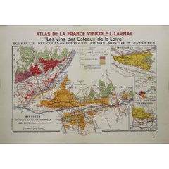
1946 original map "Les vins des côteaux de la Loire - Bourgueil" by Larmat
Located in PARIS, FR
The 1946 original map Atlas de la France Vinicole - Les Vins des Côteaux de la Loire: Bourgueil, St Nicolas-de-Bourgueil, Chinon, Montlouis, Jasnières, created by Louis Larmat and pr...
Category
1940s Prints and Multiples
Materials
Lithograph, Paper
You May Also Like
Antique Map of France by Johnston (1909)
Located in Langweer, NL
Antique map titled 'France'. Original antique map of France. With inset maps of France in provinces, part of the Riviera and Corsica. This map or...
Category
Early 20th Century Maps
Materials
Paper

$237 Sale Price
20% Off
Antique Map of France by Lapie, 1842
Located in Langweer, NL
Antique map titled 'Carte de France'. Map of France. This map originates from 'Atlas universel de géographie ancienne et moderne (..)' by Pierre M. Lapie and Alexandre E. Lapie. Pier...
Category
Antique Mid-19th Century Maps
Materials
Paper

$522 Sale Price
20% Off
Antique Map of France under the Reign of Francois I, 1765
Located in Langweer, NL
Antique map France titled 'Etat des Possessions de la Couronne (..)'.
Beautiful old map of France. This map originates from 'Atlas Historique de la France Ancienne et Moderne' by...
Category
Antique 18th Century Maps
Materials
Paper
$140 Sale Price
20% Off
Large 19th Century Map of France
Located in Pease pottage, West Sussex
Large 19th Century Map of France.
Remarkable condition, with a pleasing age worn patina.
Recently framed.
France Circa 1874.
Category
Antique Late 19th Century French Maps
Materials
Linen, Paper

Antique Map of France by A & C. Black, 1870
Located in Langweer, NL
Antique map titled 'France'. Original antique map of France with inset map of France as divided into provinces, before the revolution of 1789 and map of Corsica...
Category
Antique Late 19th Century Maps
Materials
Paper

$261 Sale Price
20% Off
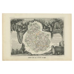
Antique Map of Côte d'Or ‘France’ by V. Levasseur, 1854
By Victor Levasseur
Located in Langweer, NL
Antique map titled 'Dépt. de la Côte d'Or'. Map of the French department of Cote D’Or, France. Part of France's Burgundy or Bourgogne wine region, a premier wine-growing region of Fr...
Category
Antique Mid-19th Century Maps
Materials
Paper
$142 Sale Price
20% Off
More Ways To Browse
Large Vintage Map
Map Case
Used Wine Barrels
Vintage French Poster Wine
Treasure Map
French Grande Poster
Vintage Alcohol Posters
Large Vintage Wine Bottles
French Poster Art Alcohol
Champagne Poster
Vineyard Poster
Vintage Champagne Labels
Wine Region Poster
French Champagne Posters
Cartographer Tool
Vintage Champagne Poster
Louis Cognac
Original Vintage Champagne Posters