Guillaume De L'Isle Wall Decorations
to
1
1
1
Height
to
Width
to
1
1
1
1
1
2
436
301
286
282
Creator: Guillaume De L'Isle
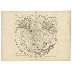
18th Century Antique Engraving of the Southern Hemisphere by G. de L'Isle
By Guillaume De L'Isle
Located in Langweer, NL
Antique map titled 'Hemisphere Meridional pour voir plus distinctement Les Terres Australes'. Hemispherical map of the southern hemisphere centered on ...
Category
Late 18th Century Antique Guillaume De L'Isle Wall Decorations
Materials
Paper
$955 Sale Price
20% Off
Related Items
Large 17th Century Hand Colored Map of England and the British Isles by de Wit
By Frederick de Wit
Located in Alamo, CA
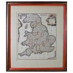
A large hand colored 17th century map of England and the British Isles by Frederick de Wit entitled "Accuratissima Angliæ Regni et Walliæ Principatus", published in Amsterdam in 1680. It is a highly detailed map of England, Scotland, the Scottish Isles...
Category
Late 17th Century Dutch Antique Guillaume De L'Isle Wall Decorations
Materials
Paper
$1,175
H 35 in W 30.5 in D 2 in
Antique Albertus Seba Pair 18th Century Hand-Colored Engravings Butterfly
By Albertus Seba 1
Located in Washington, DC
Rare pair of original hand-colored prints from Sir Albertus Seba's cabinet of natural curiosities. Prints come from published volumes in Amste...
Category
Mid-18th Century Dutch Antique Guillaume De L'Isle Wall Decorations
Materials
Paper
$700 / set
H 26 in W 12.5 in D 0.3 in
Hand-Colored 18th Century Homann Map of the Danube, Italy, Greece, Croatia
By Johann Baptist Homann
Located in Alamo, CA
"Fluviorum in Europa principis Danubii" is a hand colored map of the region about the Danube river created by Johann Baptist Homann (1663-1724) in his 'Atlas Novus Terrarum', publish...
Category
Early 18th Century German Antique Guillaume De L'Isle Wall Decorations
Materials
Paper
$875
H 20 in W 23.88 in D 0.07 in
1876 "Gettysburg, The Repulse of Longstreet's Assault." Engraving
Located in Colorado Springs, CO
Presented here is an 1876 engraving of John B. Bachelder and James Walker’s Gettysburg. The Repulse of Longstreet’s Assault. The engraved scene depicts the decisive battle on the final day of the Battle of Gettysburg. Researched by the photographer and topographer John B. Bachelder and painted by James Walker, the original painting was created in 1870. This detailed engraving was done by H. B. Hall Jr. and published by James Drummond Ball.
Otherwise called Pickett’s Charge, the battle occurred on July 3, 1863. Pickett’s corp commander, Lieutenant General James Longstreet was placed in charge of the attack despite his hesitations. Longstreet’s central role led to the title of the work, Repulse of Longstreet’s Assault. In an attempt to gain control of an important supply route, nine Confederate brigades charged across three-quarters of a mile of open ground against cannon fire to take Cemetery Ridge from the defending Union Army. Despite their overwhelming numbers, the Confederate forces were repelled with considerable casualties marking not only a decisive victory for the Union, but also the beginning of the slow defeat of Lee’s Army. The furthest the charging forces advanced before being repulsed would forever be known as the “High Water Mark of the Confederacy.” The Confederate army never recovered from the losses at Gettysburg and it effectively ended Lee’s campaign into Pennsylvania.
The engraving gives the perspective from the Union rear, one that encompasses most of the battlefield, from Big Round Top on the left to the northern reaches of Cemetery Ridge on the right. The Confederate lines at Seminary Ridge are in the far distance, partially obscured by bursting shells. The image centers on the main Confederate assault, in the vicinity of what today are known as "The Copse" and "The Bloody Angle." The composition has elemen...
Category
1870s American Antique Guillaume De L'Isle Wall Decorations
Materials
Paper
$8,500
H 26.75 in W 47.5 in D 1.5 in
19th Century Framed Engravings From The New Book Of Martyrs by Henry Southwell
Located in Lowestoft, GB
A collection of 11 framed and glazed engravings taken from the New Book Of Martyrs By Henry Southwell
The 11 engravings show authentic and genuine historical account of the many dre...
Category
19th Century English Antique Guillaume De L'Isle Wall Decorations
Materials
Glass, Pine, Paper
$962 / set
H 14.77 in W 10.24 in D 0.6 in
The Kingdom of Naples and Southern Italy: A Hand-Colored 18th Century Homann Map
By Johann Baptist Homann
Located in Alamo, CA
"Novissima & exactissimus Totius Regni Neapolis Tabula Presentis Belli Satui Accommo Data" is a hand colored map of southern Italy and the ancient Kingdom of Naples created by Johann...
Category
Early 18th Century German Antique Guillaume De L'Isle Wall Decorations
Materials
Paper
$1,175
H 20 in W 23.88 in D 0.07 in
17th Century Topographical Engraving Nantes & St. Malo, France, by Iohan Peeters
Located in New York, NY
The ancient city of Saint Malo in North Western France has long been associated with adventure on the high seas, piracy and exploration. It was the birthplace of several important in...
Category
17th Century Dutch Antique Guillaume De L'Isle Wall Decorations
Materials
Paper
$475
H 12.38 in W 15 in D 0 in
Antique 18th Century Map of the Province of Pensilvania 'Pennsylvania State'
Located in Philadelphia, PA
A fine antique of the colony of Pennsylvania.
Noted at the top of the sheet as a 'Map of the province of Pensilvania'.
This undated and anonymous map is thought to be from the Gentleman's Magazine, London, circa 1775, although the general appearance could date it to the 1760's.
The southern boundary reflects the Mason-Dixon survey (1768), the western boundary is placed just west of Pittsburgh, and the northern boundary is not marked.
The map has a number of reference points that likely refer to companion text and appear to be connected to boundaries. The western and southern boundaries are marked Q, R, S, for example. A diagonal line runs from the Susquehanna R to the Lake Erie P. A broken line marked by many letters A, B, N, O, etc., appears in the east.
There are no latitude or longitude markings, blank verso.
Framed in a shaped contemporary gilt wooden frame and matted under a cream colored matte.
Bearing an old Graham Arader Gallery...
Category
18th Century British American Colonial Antique Guillaume De L'Isle Wall Decorations
Materials
Paper
$1,250
H 10.25 in W 13.25 in D 0.5 in
18th Century Hand Colored Map of Spain and Portugal by Visscher
By Nicolaes Visscher II
Located in Alamo, CA
This is an early 18th century map of Spain and Portugal, with attractive original hand-coloring, entitled "Hispaniae et Portugalliae Regna per Nicolaum Visscher cum Privilegio Ordinu...
Category
Early 18th Century Dutch Antique Guillaume De L'Isle Wall Decorations
Materials
Paper
Hand Colored 17th Century Visscher Map "Hollandiae" Southern Holland
By Nicolaes Visscher II
Located in Alamo, CA
A hand colored 17th century map of the southern portions of Holland by Nicolaus (Nicolas) Visscher II entitled "Hollandiae pars Meridionalis, vulgo Zuyd-Holland", published in Amsterdam in 1678. The map shows the region between Breda, Heusden, Gornichem, Gouda, Dordrecht, and Willemstad. It includes a decorative cartouche in the lower left corner.
The map is presented in an attractive maple colored wood frame with gold trim and a fabric mat.
The Visscher family were one of the great cartographic families of the 17th century. Begun by Claes Jansz Visscher...
Category
Early 18th Century Dutch Antique Guillaume De L'Isle Wall Decorations
Materials
Paper
$1,275
H 26.63 in W 30.13 in D 0.88 in
City View of Nuremberg, Germany: An 18th Century Hand-Colored Map by M. Seutter
By Matthew Seutter
Located in Alamo, CA
An 18th century hand-colored city view of Nuremburg, Germany entitled "Geometrischer Grundris der des Heiligen Römischen Reichs Freyen Stadt Nürnberg" by Matthaus Seutter from his "A...
Category
Mid-18th Century German Antique Guillaume De L'Isle Wall Decorations
Materials
Paper
$1,875
H 22 in W 24.25 in D 0.13 in
“The Restaurant of the House of Representatives” Engraving by Harper's Weekly
Located in Colorado Springs, CO
This original wood engraving is titled “The Restaurant of the House of Representatives, Washington, DC.” It was published as a double-page image, in the August 12, 1893 issue of the famous 19th century newspaper Harper’s Weekly. The print was illustrated by Charles Stanley Reinhardt.
The House Restaurant, a unique part of life in the Capitol, has been in the same location since the 1857 Capitol Expansion. Congressional members’ busy work schedule made the availability of food on site a necessity. But the restaurant also served as an informal meeting spot for members to continue conversations and deal making.
This 1893 print illustrates the convivial atmosphere. Details including elegantly dressed tables...
Category
1890s American Antique Guillaume De L'Isle Wall Decorations
Materials
Paper
$950
H 24 in W 29.25 in D 1 in
Guillaume De L'isle wall decorations for sale on 1stDibs.
Guillaume De L'Isle wall decorations are available for sale on 1stDibs. These distinctive items are frequently made of paper and are designed with extraordinary care. There are many options to choose from in our collection of Guillaume De L'Isle wall decorations, although beige editions of this piece are particularly popular. If you’re looking for additional options, many customers also consider wall decorations by Jacques-Nicolas Bellin, François Boucher, and Isaak Tirion. Prices for Guillaume De L'Isle wall decorations can differ depending upon size, time period and other attributes — on 1stDibs, these items begin at $501 and can go as high as $501, while a piece like these, on average, fetch $501.
Creators Similar to Guillaume De L'Isle
Georges-Louis Leclerc, Comte de Buffon


