Willem Blaeu Wall Decorations
7
to
3
7
7
7
7
7
Height
to
Width
to
7
7
428
291
282
265
Creator: Willem Blaeu
Antique Map of the Region of Oldenburg, Germany
By Willem Blaeu
Located in Langweer, NL
Antique map titled 'Oldenburg Comitatus'. Detailed old map of Oldenburg, Germany. The map also shows Bremen and the Jade Bight. Published by W. Blaeu, circa 1640. Willem Jansz. Blaeu...
Category
Mid-17th Century Antique Willem Blaeu Wall Decorations
Materials
Paper
Original Antique Map of the Duchy of Holstein
By Willem Blaeu
Located in Langweer, NL
Antique map titled 'Ducatus Holsatiae Nova Tabula'. Original old map of the Duchy of Holstein, the northernmost territory of the Holy Roman Empire, from the mid-17th Century. To the ...
Category
Mid-17th Century Antique Willem Blaeu Wall Decorations
Materials
Paper
Old Color Engraving of Blaeu's first Map of Brazil, North Oriented to the Right
By Willem Blaeu
Located in Langweer, NL
Antique map titled 'Novus Brasiliae Typus'. Fine old color example of Blaeu's first map of Brazil, with north oriented to the right. Includes inset map of Baya de todos Santos, elaborate cartouche, 2 compass roses and richly embellished vignettes of native Brazilian life and animals.
The interior of the map includes vignettes of indigenous animals and native scenes, including cannibalism. Inset within a decorative border is a small map of "Baya de todos Sanctos". In the sea are monsters, a galleon and two compass roses. The large title cartouche features a male and female Brazilian, both of whom are shown naked.
Willem Janszoon Blaeu (1571-1638) was a prominent Dutch geographer and publisher. Born the son of a herring merchant, Blaeu chose not fish but mathematics and astronomy for his focus. He studied with the famous Danish astronomer Tycho Brahe...
Category
Mid-17th Century Antique Willem Blaeu Wall Decorations
Materials
Paper
Antique Map of the Region of Le Mans 'France' by Blaeu, circa 1640
By Willem Blaeu
Located in Langweer, NL
Antique map titled 'Cenomanorum Galliae regionis typus vulgo le Mans'. This lovely map of the historical province of Maine is centered on the famous city of Le Mans. This region witn...
Category
Mid-17th Century Antique Willem Blaeu Wall Decorations
Materials
Paper
Orignal Hand-Colored Antique Map of Chili by W. Blaeu, 1658
By Willem Blaeu
Located in Langweer, NL
Very decorative antique map of Chili published by W. Blaeu, 1658. This map depicts Chile from Copiapo southward to the island of Chiloé with ships and sea monsters adorning the sea. ...
Category
Mid-17th Century Antique Willem Blaeu Wall Decorations
Materials
Paper
Antique Map of Prussia by Blaeu, circa 1635
By Willem Blaeu
Located in Langweer, NL
Antique map titled 'Prussiae Nova Tabula'. Rare early edition of Blaeu's map of Prussia, embellished with a gorgeous large format cartouche, compass ros...
Category
Mid-17th Century Antique Willem Blaeu Wall Decorations
Materials
Paper
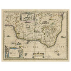
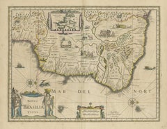
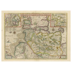
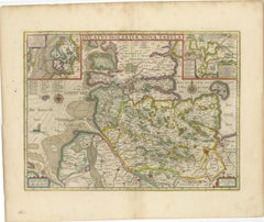
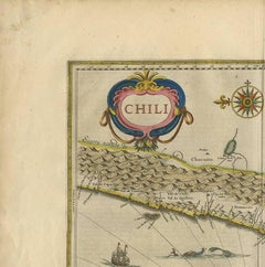
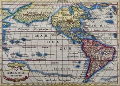
Antique Map of the Spice Islands 'Moluccas', Indonesia by W. Blaeu, circa 1640
By Willem Blaeu
Located in Langweer, NL
Antique map titled 'Moluccae Insulae Celeberrimae'. Highly decorative antique map of the Spice Islands (Moluccas) published by W. Blaeu (circa 1640). This map features a large inset ...
Category
Mid-17th Century Antique Willem Blaeu Wall Decorations
Materials
Paper
Related Items
Original Antique Map of South East Asia, Arrowsmith, 1820
Located in St Annes, Lancashire
Great map of South East Asia
Drawn under the direction of Arrowsmith
Copper-plate engraving
Published by Longman, Hurst, Rees, Orme and Brown, 1820
Unframed.
Category
1820s English Antique Willem Blaeu Wall Decorations
Materials
Paper
Manly P Hall, the Secret Teachings of All Ages, First Edition Book & 4 Prints
By TASCHEN
Located in Los Angeles, CA
The classic encyclopedia of the arcane in an expanded edition.
Renowned philosopher and lecturer Manly P. Hall’s masterful encyclopedia of ancient symbols, hidden rituals, and arcane practices has remained a classic since first published in 1928. Hall’s densely detailed writings explore topics ranging from Hermeticism to Tarot, Egyptian mythology to Pythagorean theory. Each chapter is accompanied by the vivid illustrations of artist J. Augustus Knapp, with additional images by Mihran Serailian found in the companion volume, each taking their own unique approach to nearly 60 artworks depicting occult subject matter.
The initial concept for what became known as Hall’s “Great Book”, first began in 1923 when the young Los Angeles-based orator began a months-long trip around the globe. Circumnavigating by ship, Hall visited Egypt, China and India, immersing himself in the philosophical and religious history of each country. Upon his return he spent the next five years penning his massive compendium of philosophy and myth.
Nearly a century after its release, this iconic masterwork has been reproduced for the first time from the rare and extravagant original edition. This meticulously-restored version of Hall’s “Great Book” is also accompanied by an expansive companion book, featuring condensed summaries of each chapter of The Secret Teachings, alongside newly-discovered artworks, rare photography...
Category
21st Century and Contemporary Willem Blaeu Wall Decorations
Materials
Foil
H 18.7 in W 13.2 in D 3 in
Original Antique Map of India. C.1780
Located in St Annes, Lancashire
Great map of India
Copper-plate engraving
Published C.1780
Three small worm holes to right side of map and one bottom left corner
Unframed.
Category
Early 1800s English Georgian Antique Willem Blaeu Wall Decorations
Materials
Paper
Original Antique Map of Spain and Portugal, circa 1790
Located in St Annes, Lancashire
Super map of Spain and Portugal
Copper plate engraving by A. Bell
Published, circa 1790.
Unframed.
Category
1790s English Other Antique Willem Blaeu Wall Decorations
Materials
Paper
Original Antique Map of Asia. C.1780
Located in St Annes, Lancashire
Great map of Asia
Copper-plate engraving
Published C.1780
Two small worm holes to right side of map
Unframed.
Category
Early 1800s English Georgian Antique Willem Blaeu Wall Decorations
Materials
Paper
Original Antique Map of Italy. C.1780
Located in St Annes, Lancashire
Great map of Italy
Copper-plate engraving
Published C.1780
Unframed.
Category
Early 1800s English Georgian Antique Willem Blaeu Wall Decorations
Materials
Paper
17th Century Hand-Colored Map of West Africa by Mercator/Hondius
Located in Alamo, CA
A 17th century hand-colored map entitled "Guineae Nova Descriptio" by Gerard Mercator and Jodocus Hondius, published in their 'Atlas Minor' in Amsterdam in 1635. It is focused on the...
Category
Mid-17th Century Dutch Antique Willem Blaeu Wall Decorations
Materials
Paper
Original Antique Map of Switzerland, Engraved By Barlow, Dated 1807
Located in St Annes, Lancashire
Great map of Switzerland
Copper-plate engraving by Barlow
Published by Brightly & Kinnersly, Bungay, Suffolk.
Dated 1807
Unframed.
Category
Early 1800s English Antique Willem Blaeu Wall Decorations
Materials
Paper
No Reserve
H 8 in W 10 in D 0.07 in
The Prints of Reginald Marsh by Norman Sasowsky, Catalog Raisonne, First Edition
Located in valatie, NY
The Prints of Reginald Marsh by Norman Sasowsky. Clarkson N. Potter, Inc. / Publisher / Distributed by Crown Publishers, Inc., New York, 1976. First Edition hardcover with dust jacke...
Category
1970s American Vintage Willem Blaeu Wall Decorations
Materials
Paper
H 3.94 in W 3.65 in D 0.4 in
Original Antique Map of Ancient Greece, Phocis, Gulf of Corinth, 1787
Located in St Annes, Lancashire
Great map of Ancient Greece. Showing the region of Phocis, including the Gulf of Corinth
Drawn by J.D. Barbie Du Bocage
Copper plate engraving by P.F Tardieu
Original hand c...
Category
1780s French Other Antique Willem Blaeu Wall Decorations
Materials
Paper
No Reserve
H 10 in W 14 in D 0.07 in
New Map of North America from the Latest Discoveries, 1763
Located in Philadelphia, PA
A fine antique 18th century map of the North American seaboard.
Entitled "A New Map of North America from the Latest Discoveries 1763".
By the Cartographer/Engraver - John Spil...
Category
Mid-18th Century English Georgian Antique Willem Blaeu Wall Decorations
Materials
Paper
Original Antique Map of The Netherlands, Engraved by Barlow, Dated 1807
Located in St Annes, Lancashire
Great map of Netherlands
Copper-plate engraving by Barlow
Published by Brightly & Kinnersly, Bungay, Suffolk.
Dated 1807
Unframed.
Category
Early 1800s English Antique Willem Blaeu Wall Decorations
Materials
Paper
No Reserve
H 8 in W 10 in D 0.07 in
Willem Blaeu wall decorations for sale on 1stDibs.
Willem Blaeu wall decorations are available for sale on 1stDibs. These distinctive items are frequently made of paper and are designed with extraordinary care. There are many options to choose from in our collection of Willem Blaeu wall decorations, although beige editions of this piece are particularly popular. If you’re looking for additional options, many customers also consider wall decorations by Gerard Mercator, Arnoldus Montanus, and Nicolaes Visscher II. Prices for Willem Blaeu wall decorations can differ depending upon size, time period and other attributes — on 1stDibs, these items begin at $488 and can go as high as $1,997, while a piece like these, on average, fetch $637.