Items Similar to Orignal Hand-Colored Antique Map of Chili by W. Blaeu, 1658


Want more images or videos?
Request additional images or videos from the seller
1 of 6
Orignal Hand-Colored Antique Map of Chili by W. Blaeu, 1658
About the Item
Very decorative antique map of Chili published by W. Blaeu, 1658. This map depicts Chile from Copiapo southward to the island of Chiloé with ships and sea monsters adorning the sea. The map is oriented with north to the left – noted by the two bold compass roses. Topographical features are shown and waterways identified.
The Andes are prominently shown with two live volcanoes in the vicinity of Villarrica. Beyond the mountains, in what is now Argentina is a large unnamed (and nonexistent) lake with the cities of Mendoza and San Juan (San Juan is incorrectly placed to the south of Mendoza).
Most cities, towns, Indian villages, and missions are located. Some present-day cities are recognizable, such as Santiago (marked S Iago dela Nueva Estremadura), Valparaíso (marked as a river estuary), Concepción and Valdivia (spelled Baldivia on the map).
- Creator:Willem Blaeu (Artist)
- Dimensions:Height: 21.86 in (55.5 cm)Width: 25.99 in (66 cm)Depth: 0.02 in (0.5 mm)
- Materials and Techniques:
- Period:Mid-17th Century
- Date of Manufacture:1658
- Condition:Please study images carefully.
- Seller Location:Langweer, NL
- Reference Number:
About the Seller
5.0
Platinum Seller
These expertly vetted sellers are 1stDibs' most experienced sellers and are rated highest by our customers.
Established in 2009
1stDibs seller since 2017
1,932 sales on 1stDibs
Typical response time: <1 hour
- ShippingRetrieving quote...Ships From: Langweer, Netherlands
- Return PolicyA return for this item may be initiated within 14 days of delivery.
More From This SellerView All
- Antique Map of Prussia by Blaeu, circa 1635By Willem BlaeuLocated in Langweer, NLAntique map titled 'Prussiae Nova Tabula'. Rare early edition of Blaeu's map of Prussia, embellished with a gorgeous large format cartouche, compass ros...Category
Antique Mid-17th Century Maps
MaterialsPaper
- Antique Map of the Spice Islands 'Moluccas', Indonesia by W. Blaeu, circa 1640By Willem BlaeuLocated in Langweer, NLAntique map titled 'Moluccae Insulae Celeberrimae'. Highly decorative antique map of the Spice Islands (Moluccas) published by W. Blaeu (circa 1640). This map features a large inset ...Category
Antique Mid-17th Century Maps
MaterialsPaper
- Antique Map of the Region of Le Mans 'France' by Blaeu, circa 1640By Willem BlaeuLocated in Langweer, NLAntique map titled 'Cenomanorum Galliae regionis typus vulgo le Mans'. This lovely map of the historical province of Maine is centered on the famous city of Le Mans. This region witn...Category
Antique Mid-17th Century Maps
MaterialsPaper
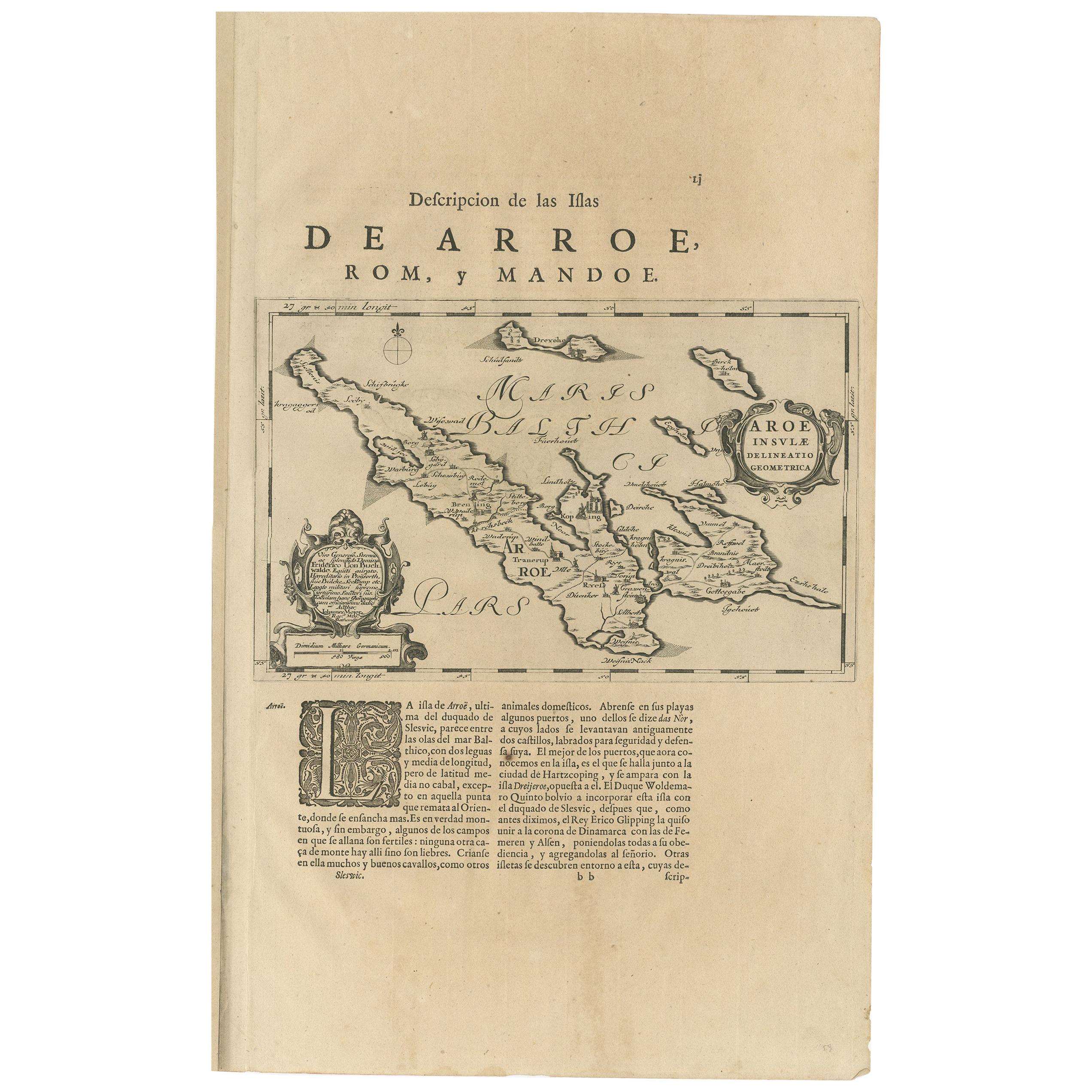
- Antique Map of Aero by Blaeu, 'circa 1670'Located in Langweer, NLAntique map titled 'Aroe Insulae delineatio geometrica'. Old map of Aero, a small Danish island in the Baltic Sea. This map originates from a Spanish edition of 'Atlas Maior' by J. B...Category
Antique Mid-17th Century Maps
MaterialsPaper
- Antique Map of Catalonia by Blaeu, circa 1650Located in Langweer, NLAntique map titled 'Catalonia'. Antique map of Catalonia, extending from C. De Romani on the Northern Coast to Alfachs and Panicola in Valencia on the southern end of the coast and s...Category
Antique Mid-17th Century Maps
MaterialsPaper
- Antique Map of Central Sweden by J. Blaeu, 1662Located in Langweer, NLA striking, rare map with a cartouche dedicated to Gabriel Bengtsson Oxenstierna. Published by J. Bleau, Amsterdam, 1662. Contemporary coloring.Category
Antique Mid-17th Century Maps
MaterialsPaper


You May Also Like
- 17th Century Map of Denmark by French Cartographer Sanson, Dated 1658By Nicolas SansonLocated in Copenhagen, K17th century map of Denmark by French cartographer Sanson. Nicolas Sanson (20 December 1600-7 July 1667) was a French cartographer, termed by some the creator of French geography an...Category
Antique 17th Century French Maps
MaterialsPaper
- England, Scotland & Ireland: A Hand Colored Map of Great Britain by TirionBy Isaak TirionLocated in Alamo, CAThis is a hand-colored double page copperplate map of Great Britain entitled "Nieuwe Kaart van de Eilanden van Groot Brittannien Behelzende de Kon...Category
Antique Mid-18th Century Dutch Maps
MaterialsPaper
- 17th Century Hand-Colored Map of West Africa by Mercator/HondiusLocated in Alamo, CAA 17th century hand-colored map entitled "Guineae Nova Descriptio" by Gerard Mercator and Jodocus Hondius, published in their 'Atlas Minor' in Amsterdam in 1635. It is focused on the...Category
Antique Mid-17th Century Dutch Maps
MaterialsPaper
- "Africa Vetus": a 17th Century Hand-Colored Map by SansonBy Nicolas SansonLocated in Alamo, CAThis original hand-colored copperplate engraved map of Africa entitled "Africa Vetus, Nicolai Sanson Christianiss Galliar Regis Geographi" was originally created by Nicholas Sanson d...Category
Antique Late 17th Century French Maps
MaterialsPaper
- Captain Cook's Exploration of Tahiti 18th C. Hand-Colored Map by BellinBy Jacques-Nicolas BellinLocated in Alamo, CAThis beautiful 18th century hand-colored copper plate engraved map is entitled "Carte de l'Isle de Taiti, par le Lieutenant J. Cook" was created by Jacques Nicolas Bellin and publish...Category
Antique Mid-18th Century French Maps
MaterialsPaper
- Sweden & Adjacent Portions of Scandinavia: A Hand-Colored 18th C. Map by HomannBy Johann Baptist HomannLocated in Alamo, CAThis hand-colored map of Sweden and adjacent portions of Scandinavia entitled "Regni Sueciae in Omnes suas Subjacentes Provincias accurate divisi Tabula Generalis" was created by Joh...Category
Antique 1720s German Maps
MaterialsPaper


Recently Viewed
View AllMore Ways To Browse
Argentine Antiques
Antique Argentine
Argentine Antique Furniture
South Indian Antique Furniture
Antique South Indian Furniture
Antique Monster
Sea Monster
San Juan Islands
Antique Map Orient
Antique Sea Monster
Chilean Antiques
Argentina Map
Valparaiso Chile
Antique Map Chile
Antique Map Argentina
Antique Map Of Argentina
Willem Blaeu On Sale
Antique Furniture South East London