Pinkerton Maps
to
1
1
1
1
1
1
1
1
1
1
1
1
104
63
28
24
Creator: Pinkerton
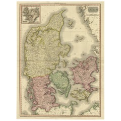
Denmark – Large Format Antique Map by Pinkerton, Fine English Engraving c.1814
By Pinkerton
Located in Langweer, NL
Denmark – Large Format Antique Map by Pinkerton, Fine English Engraving c.1814
This impressive antique map of Denmark originates from John Pinkerton’s celebrated Modern Atlas, publi...
Category
Early 19th Century English Antique Pinkerton Maps
Materials
Paper
$403 Sale Price
30% Off
Related Items
Original Antique Map of South East Asia by Thomas Clerk, 1817
Located in St Annes, Lancashire
Great map of South East Asia
Copper-plate engraving
Drawn and engraved by Thomas Clerk, Edinburgh.
Published by Mackenzie And Dent, 1817
Unframed.
Category
1810s English Antique Pinkerton Maps
Materials
Paper
Original Antique Map of South America. C.1780
Located in St Annes, Lancashire
Great map of South America
Copper-plate engraving
Published C.1780
Two small worm holes to left side of map
Unframed.
Category
Early 1800s English Georgian Antique Pinkerton Maps
Materials
Paper
Antique Map of Principality of Monaco
By Antonio Vallardi Editore
Located in Alessandria, Piemonte
ST/619 - "Old Geographical Atlas of Italy - Topographic map of ex-Principality of Monaco" -
ediz Vallardi - Milano -
A somewhat special edition ---
Category
Late 19th Century Italian Other Antique Pinkerton Maps
Materials
Paper
Original Antique Map of Sweden, Engraved by Barlow, 1806
Located in St Annes, Lancashire
Great map of Sweden
Copper-plate engraving by Barlow
Published by Brightly & Kinnersly, Bungay, Suffolk. 1806
Unframed.
Category
Early 1800s English Antique Pinkerton Maps
Materials
Paper
Original Antique Map of The World by Thomas Clerk, 1817
Located in St Annes, Lancashire
Great map of The Eastern and Western Hemispheres
On 2 sheets
Copper-plate engraving
Drawn and engraved by Thomas Clerk, Edinburgh.
Published by Mackenzie And Dent, 1817
...
Category
1810s English Antique Pinkerton Maps
Materials
Paper
Original Antique Map of Europe, Arrowsmith, 1820
Located in St Annes, Lancashire
Great map of Europe
Drawn under the direction of Arrowsmith.
Copper-plate engraving.
Published by Longman, Hurst, Rees, Orme and Brown, 1820
...
Category
1820s English Antique Pinkerton Maps
Materials
Paper
Africa: A Large 17th Century Hand-Colored Map by Sanson and Jaillot
By Nicolas Sanson
Located in Alamo, CA
This large original hand-colored copperplate engraved map of Africa entitled "L'Afrique divisee suivant l'estendue de ses principales parties ou sont distingues les uns des autres, L...
Category
1690s French Antique Pinkerton Maps
Materials
Paper
$2,175
H 24.88 in W 38 in D 0.13 in
Original Antique Map of Ireland- Kerry. C.1840
Located in St Annes, Lancashire
Great map of Kerry
Steel engraving
Drawn under the direction of A.Adlard
Published by How and Parsons, C.1840
Unframed.
Category
1840s English Antique Pinkerton Maps
Materials
Paper
"Rough Shooting" First Edition Antique Engraving by Douglas Adams, circa 1893
By Douglas Adams
Located in Colorado Springs, CO
This is a first edition print of Rough Shooting, signed by the artist, Douglas Adams. The print was published by Thomas McLean and depicts a highlands s...
Category
1890s British Antique Pinkerton Maps
Materials
Paper
$3,950
H 26 in W 36 in D 1 in
Original Antique Map of Switzerland, Engraved By Barlow, Dated 1807
Located in St Annes, Lancashire
Great map of Switzerland
Copper-plate engraving by Barlow
Published by Brightly & Kinnersly, Bungay, Suffolk.
Dated 1807
Unframed.
Category
Early 1800s English Antique Pinkerton Maps
Materials
Paper
Original Antique English County Map, Durham, J & C Walker, 1851
Located in St Annes, Lancashire
Great map of Durham
Original colour
By J & C Walker
Published by Longman, Rees, Orme, Brown & Co. 1851
Unframed.
Category
1850s English Other Antique Pinkerton Maps
Materials
Paper
Southern & Eastern Europe: A Large 17th C. Hand-colored Map by Sanson & Jaillot
By Nicolas Sanson
Located in Alamo, CA
This large hand-colored map entitled "Estats de L'Empire des Turqs en Europe, ou sont les Beglerbeglicz our Gouvernements" was originally created by Nicholas Sanson d'Abbeville and t...
Category
1690s French Antique Pinkerton Maps
Materials
Paper
$2,175
H 24.88 in W 38 in D 0.13 in
Pinkerton maps for sale on 1stDibs.
Pinkerton maps are available for sale on 1stDibs. These distinctive items are frequently made of paper and are designed with extraordinary care. There are many options to choose from in our collection of Pinkerton maps, although beige editions of this piece are particularly popular. If you’re looking for additional options, many customers also consider maps by James Cook, Victor Levasseur, and Jacques-Nicolas Bellin. Prices for Pinkerton maps can differ depending upon size, time period and other attributes — on 1stDibs, these items begin at $331 and can go as high as $331, while a piece like these, on average, fetch $331.


