Theodorus Danckerts Maps
to
1
1
1
1
1
1
1
1
1
2
104
63
28
24
Creator: Theodorus Danckerts
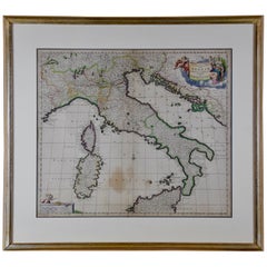
Italy, Sicily, Sardinia, Corsica and Dalmatian Coast: A 17th Century Dutch Map
By Theodorus Danckerts
Located in Alamo, CA
This hand colored 17th century Dutch map entitled "Novissima et Accuratissima totius Italiae Corsicae et Sardiniae Descriptio" by Theodore Danckerts depicts the Italian Peninsula in ...
Category
Late 17th Century Dutch Antique Theodorus Danckerts Maps
Materials
Paper
Related Items
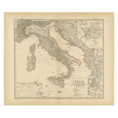
Map of The Italian Peninsula with the islands of Sicily, Sardinia, Corsica, 1880
Located in Langweer, NL
This map, titled "ITALIA, Sicilia, Sardinia, Corsica," represents the Italian Peninsula along with the islands of Sicily, Sardinia, and Corsica. Inset maps offer detailed views of "R...
Category
1880s Antique Theodorus Danckerts Maps
Materials
Paper
$354 Sale Price
20% Off
H 15.56 in W 18.51 in D 0 in
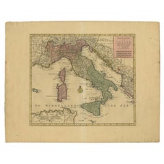
Antique Map of Italy, Showing Corsica, Sardinia, Croatia, Malta and More, C.1740
Located in Langweer, NL
Antique map titled 'Nieuwe Kaart van Italie na de Nieuwste waarnemingen van de l'Isle en andere.'
Attractive detailed map showing Italy as well as Corsica, Sardinia, Minorca, Croat...
Category
18th Century Antique Theodorus Danckerts Maps
Materials
Paper
$658
H 21.78 in W 17.13 in D 0 in
Coloured Antique Map of Sicily, Sardinia, Corfu, Elba, Malta and Zerbi (Jerba)
By Abraham Ortelius
Located in Langweer, NL
Antique map titled 'Insularum Aliquot Maris Mediterranei Descriptio'. A very attractive example of Ortelius' map combining, on one page, maps of the islands of Sicily, Sardinia, Corfu, Elba, Malta and Zerbi (Jerba, off the coast of Tunisia.) The maps detail fortifications on the islands and other major features. (Jerba, for instance, is shown connected to the mainland by a causeway.) The waters are attractively engraved and are sailed by ships. A shipwreck, north of Malta, indicates the point at which St. Paul is thought to have shipwrecked. Volcanoes are indicated in the Sicily map...
Category
16th Century Antique Theodorus Danckerts Maps
Materials
Paper
$1,580 Sale Price
40% Off
H 17.52 in W 22.45 in D 0.02 in
Antique Print of Decorative Art in the 16th and 17th Century, 1869
Located in Langweer, NL
Old print of decorative art in the 16th and 17th century. This print originates from 'L'Ornement polychrome'. A beautiful work containing about 2000 patterns of all the styles of Art...
Category
19th Century Antique Theodorus Danckerts Maps
Materials
Paper
$143 Sale Price
20% Off
H 15.16 in W 10.63 in D 0 in
Antique Map of the Coast of Roussillon, France
Located in Langweer, NL
Antique map titled 'Coste de Roussillon depuis Port Vendres, jusqu'au golphe de Rozes'. Original map of the coast of Roussillon, France. This map originates from 'Le Petit Atlas Mari...
Category
Mid-18th Century Antique Theodorus Danckerts Maps
Materials
Paper
Antique Map of the Coast of France Between Brest and Bayonne
Located in Langweer, NL
Antique map titled 'Carte des Costes de France depuis Brest jusquá Bayone'. Original old map of the coast of France between Brest and Bayonne. This map originates from 'Le Petit Atla...
Category
Mid-18th Century Antique Theodorus Danckerts Maps
Materials
Paper
$306 Sale Price
20% Off
H 18.31 in W 12.6 in D 0.02 in
Antique Map of the Languedoc Coast between Agde and Sète 'Cette', France
Located in Langweer, NL
Antique map titled 'Coste de Languedoc depuis Agde jusqu'a Cette'. Original map of the Languedoc coast between Agde and Sète (historically Cette), France. This map originates from 'L...
Category
Mid-18th Century Antique Theodorus Danckerts Maps
Materials
Paper
$325 Sale Price
20% Off
H 12.49 in W 8.98 in D 0.02 in
Antique Map of Italy, 1903, Featuring Islands of Sardinia and Sicily
Located in Langweer, NL
Title: Antique Map of Italy, 1903, Featuring Islands of Sardinia and Sicily
Description:
This finely detailed antique map, titled "Italy," was engraved and published in 1903 by the ...
Category
Early 20th Century Theodorus Danckerts Maps
Materials
Paper
$371
H 14.49 in W 18.9 in D 0.01 in
17th Century Topographical Engraving Nantes & St. Malo, France, by Iohan Peeters
Located in New York, NY
The ancient city of Saint Malo in North Western France has long been associated with adventure on the high seas, piracy and exploration. It was the birthplace of several important in...
Category
17th Century Dutch Antique Theodorus Danckerts Maps
Materials
Paper
$475
H 12.38 in W 15 in D 0 in
Antique Map of South Italy and the Island of Sardinia by Johnston (1909)
Located in Langweer, NL
Antique map titled 'South Italy and the Island of Sardinia'. Original antique map of South Italy and the Island of Sardinia. With inset map of Naples. Th...
Category
Early 20th Century Theodorus Danckerts Maps
Materials
Paper
$239 Sale Price
20% Off
H 19.49 in W 24.41 in D 0.02 in
Dutch Antique Map of the West Coast of Africa, to the Cape of Good Hope, 1747
Located in Langweer, NL
Antique map of the Coast of Africa titled 'Kaart van de West Kust van Afrika (..)'.
Map of the west coast of Africa, from 11 degrees south latitude to the Cape of Good Hope. This...
Category
1740s Antique Theodorus Danckerts Maps
Materials
Paper
$373 Sale Price
20% Off
H 10.63 in W 12.6 in D 0 in
17th Century Toulouse, Savve, Sommieres Topographical Map by Iohan Peeters
Located in New York, NY
Fine topographical 17th century map of Toulouse, Savve and Sommieres by Iohan Peeters
Beautiful engraving of the capital of France's Occitanie Region, Toulouse, called La Ville Rose- the Pink City, for the terracotta bricks used in its many buildings, giving the city a distinct apricot-rose hue. An important cultural and educational center, the city's residents included Nobel Prize winners and world renown artists- Henri de Toulouse-Lautrec, Henri Martin, Jean-Auguste-Dominique Ingres, Antonin Mercie, Alexandre Falguiere and more recently Cyril Kongo...
Category
17th Century Dutch Antique Theodorus Danckerts Maps
Materials
Paper
$475
H 12.38 in W 14.88 in D 0 in
Theodorus Danckerts maps for sale on 1stDibs.
Theodorus Danckerts maps are available for sale on 1stDibs. These distinctive items are frequently made of paper and are designed with extraordinary care. There are many options to choose from in our collection of Theodorus Danckerts maps, although gray editions of this piece are particularly popular. If you’re looking for additional options, many customers also consider maps by Nicolaes Visscher II, Isaak Tirion, and Willem Blaeu. Prices for Theodorus Danckerts maps can differ depending upon size, time period and other attributes — on 1stDibs, these items begin at $1,475 and can go as high as $1,475, while a piece like these, on average, fetch $1,475.


