Items Similar to Coloured Antique Map of Sicily, Sardinia, Corfu, Elba, Malta and Zerbi (Jerba)


Want more images or videos?
Request additional images or videos from the seller
1 of 7
Coloured Antique Map of Sicily, Sardinia, Corfu, Elba, Malta and Zerbi (Jerba)
About the Item
Antique map titled 'Insularum Aliquot Maris Mediterranei Descriptio'. A very attractive example of Ortelius' map combining, on one page, maps of the islands of Sicily, Sardinia, Corfu, Elba, Malta and Zerbi (Jerba, off the coast of Tunisia.) The maps detail fortifications on the islands and other major features. (Jerba, for instance, is shown connected to the mainland by a causeway.) The waters are attractively engraved and are sailed by ships. A shipwreck, north of Malta, indicates the point at which St. Paul is thought to have shipwrecked. Volcanoes are indicated in the Sicily map at Etna, Vulcano and Filicudi.
Abraham Ortelius is perhaps the best known and most frequently collected of all sixteenth-century mapmakers. Ortelius started his career as a map colorist. In 1547 he entered the Antwerp guild of St Luke as afsetter van Karten. His early career was as a business man, and most of his journeys before 1560, were for commercial purposes. In 1560, while traveling with Gerard Mercator to Trier, Lorraine, and Poitiers, he seems to have been attracted, largely by Mercator’s influence, towards a career as a scientific geographer. From that point forward, he devoted himself to the compilation of his Theatrum Orbis Terrarum (Theatre of the World), which would become the first modern atlas.
- Creator:Abraham Ortelius (Artist)
- Dimensions:Height: 17.52 in (44.5 cm)Width: 22.45 in (57 cm)Depth: 0.02 in (0.5 mm)
- Materials and Techniques:
- Period:
- Date of Manufacture:c.1579
- Condition:Wear consistent with age and use. General age-related toning. Original folding line. Some wear and soiling. Latin text on verso, also two pieces of tape on verso. Please study image carefully.
- Seller Location:Langweer, NL
- Reference Number:
About the Seller
5.0
Platinum Seller
These expertly vetted sellers are 1stDibs' most experienced sellers and are rated highest by our customers.
Established in 2009
1stDibs seller since 2017
1,919 sales on 1stDibs
Typical response time: <1 hour
- ShippingRetrieving quote...Ships From: Langweer, Netherlands
- Return PolicyA return for this item may be initiated within 14 days of delivery.
More From This SellerView All
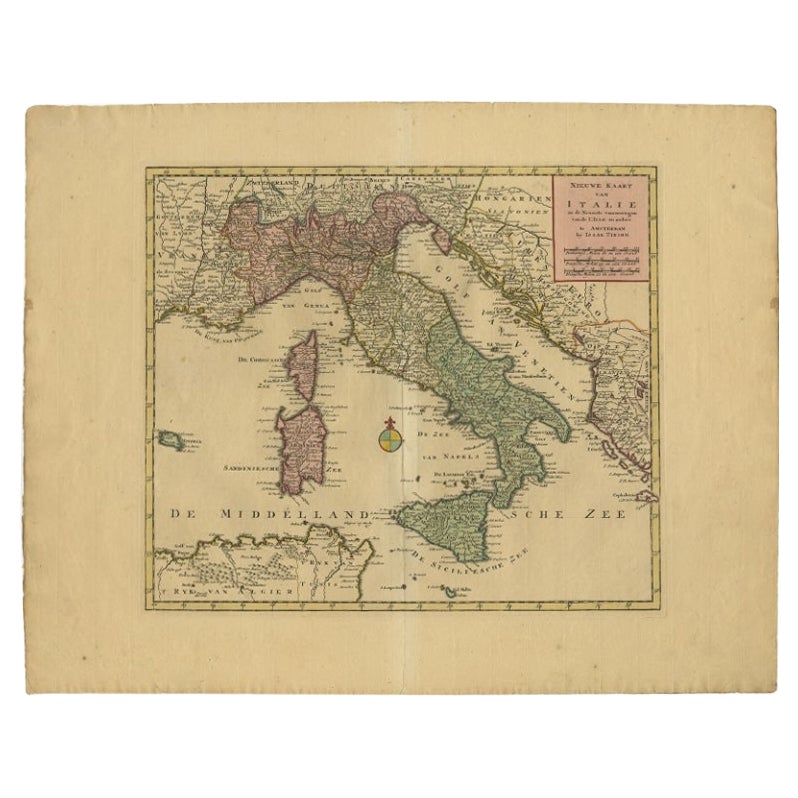
- Antique Map of Italy, Showing Corsica, Sardinia, Croatia, Malta and More, C.1740Located in Langweer, NLAntique map titled 'Nieuwe Kaart van Italie na de Nieuwste waarnemingen van de l'Isle en andere.' Attractive detailed map showing Italy as well as Corsica, Sardinia, Minorca, Croat...Category
Antique 18th Century Maps
MaterialsPaper
- Antique Map of Greece with an Inset Map of Corfu, 1854Located in Langweer, NLAntique map titled 'Hellas or Greece'. Old map of Greece with an inset map of Corfu. This map orginates from 'General Atlas Of The World: Containing Upwards Of Seventy Maps (..)' by ...Category
Antique 19th Century Maps
MaterialsPaper
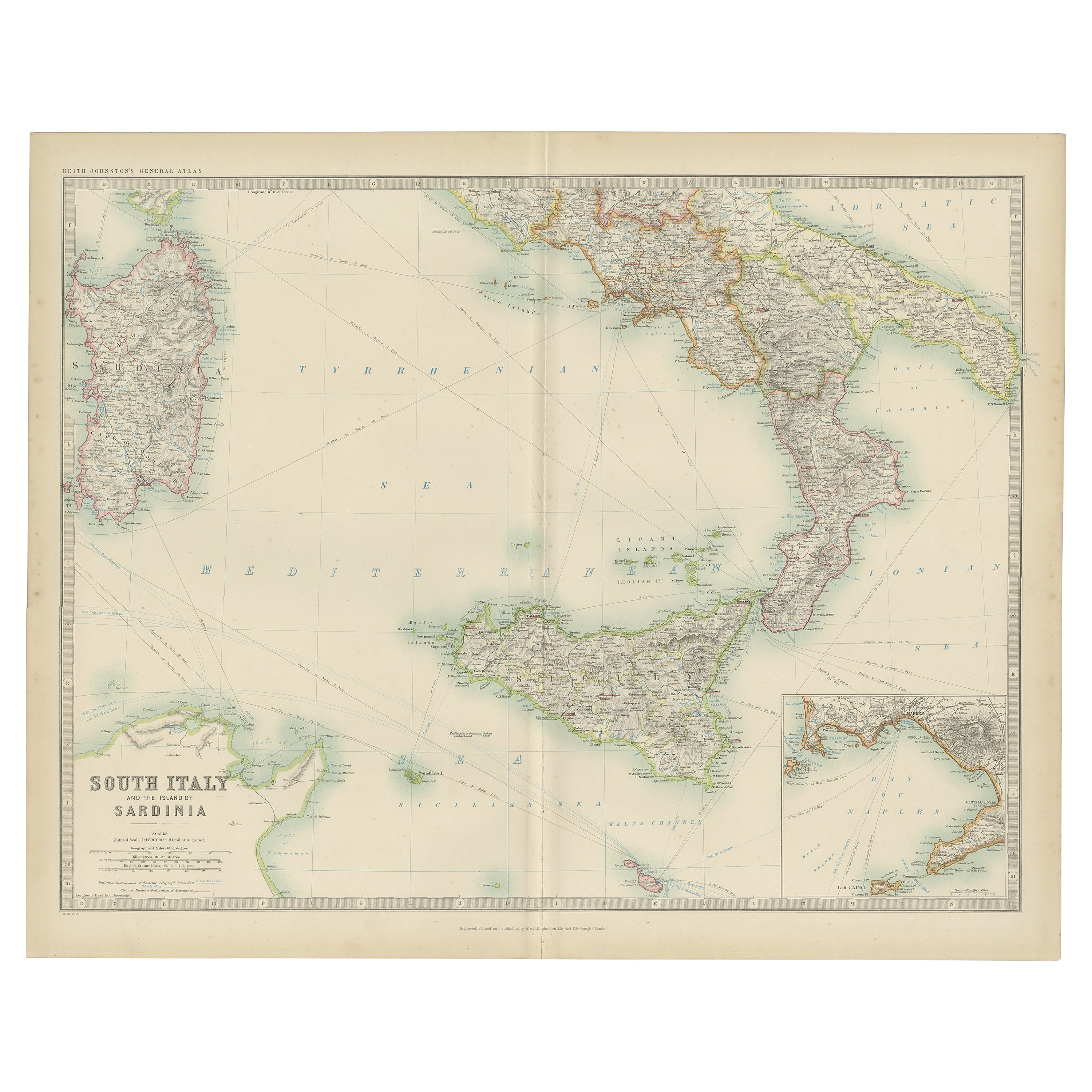
- Antique Map of South Italy and the Island of Sardinia by Johnston (1909)Located in Langweer, NLAntique map titled 'South Italy and the Island of Sardinia'. Original antique map of South Italy and the Island of Sardinia. With inset map of Naples. Th...Category
Early 20th Century Maps
MaterialsPaper
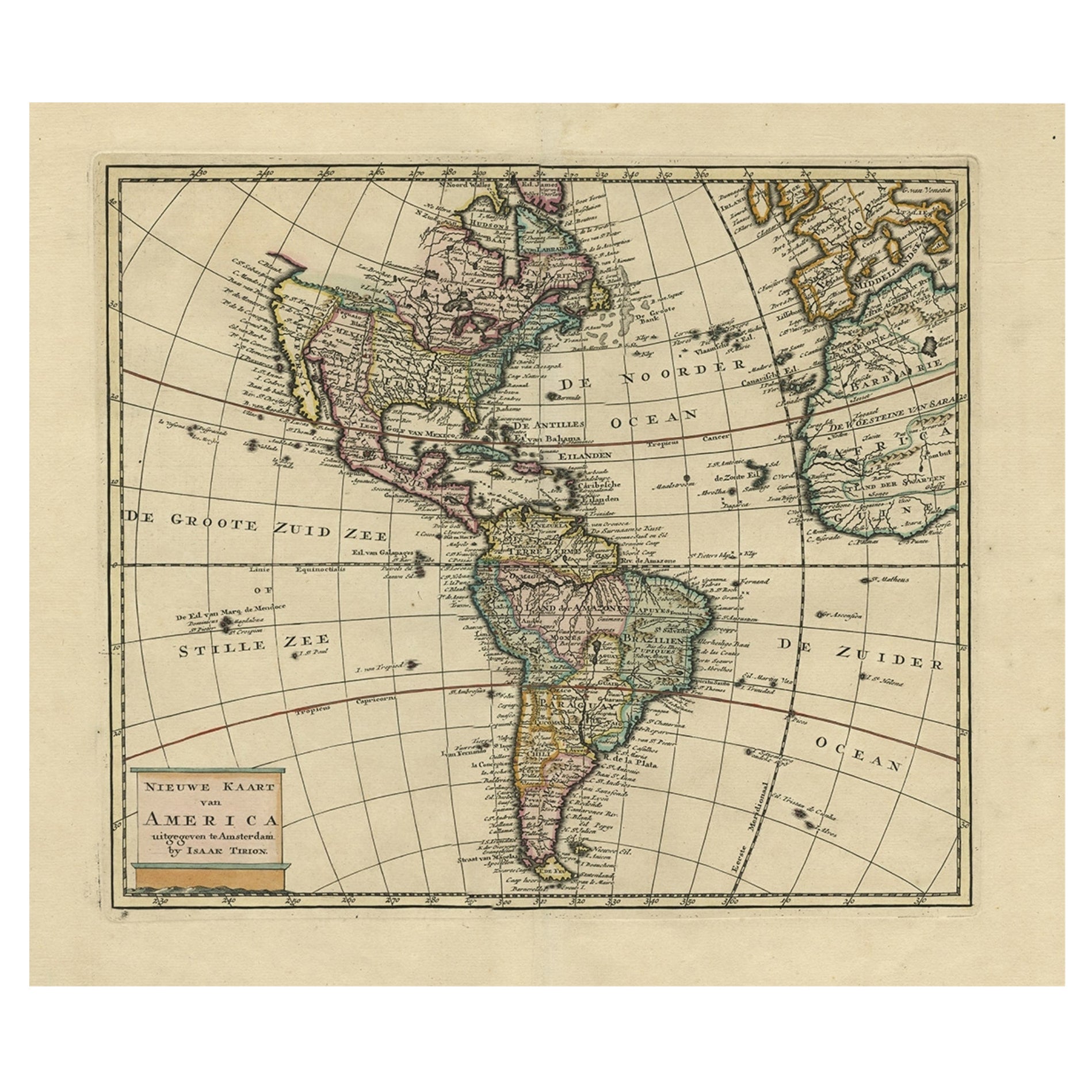
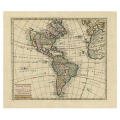
- Antique Hand-Coloured Map of North and South America, ca.1765Located in Langweer, NLDescription: Antique map titled 'Nieuwe Kaart van Amerika.' Attractive map of North and South America, the western part of Africa and south west Europe. Source unknown, to be determi...Category
Antique 1760s Maps
MaterialsPaper
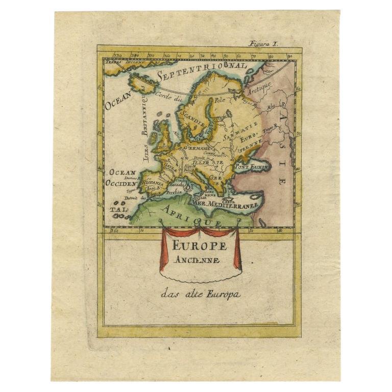
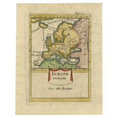
- Antique Hand-Coloured Miniature Map of Ancient Europe, c.1685Located in Langweer, NLAntique map of Europe titled 'Europe Ancienne, Das alte Europa'. Hand-coloured miniature map with much detail. German subtitle. Artists and Engravers: Alain Manneson Mallet (1630-...Category
Antique 17th Century Maps
MaterialsPaper
- Antique Map of Southeast Asia by Ortelius '1587'By Abraham OrteliusLocated in Langweer, NLAntique map titled 'Indiae Orientalis Insularumque Adiacientium Typus'. Ortelius includes early European depictions of both Japan and China and is the first to name Formosa (Taiwan). The Philippines and East Indies or Spice Islands are shown based upon Portuguese and Spanish sources, and before their penetration by the Dutch. Japan is shown in kite form, as a large oval island...Category
Antique 16th Century Maps
MaterialsPaper


You May Also Like
- Italy, Sicily, Sardinia, Corsica and Dalmatian Coast: A 17th Century Dutch MapBy Theodorus DanckertsLocated in Alamo, CAThis hand colored 17th century Dutch map entitled "Novissima et Accuratissima totius Italiae Corsicae et Sardiniae Descriptio" by Theodore Danckerts depicts the Italian Peninsula in ...Category
Antique Late 17th Century Dutch Maps
MaterialsPaper
- Antique Map of Principality of MonacoBy Antonio Vallardi EditoreLocated in Alessandria, PiemonteST/619 - "Old Geographical Atlas of Italy - Topographic map of ex-Principality of Monaco" - ediz Vallardi - Milano - A somewhat special edition ---Category
Antique Late 19th Century Italian Other Prints
MaterialsPaper
- Original Antique Map of Spain and Portugal, circa 1790Located in St Annes, LancashireSuper map of Spain and Portugal Copper plate engraving by A. Bell Published, circa 1790. Unframed.Category
Antique 1790s English Other Maps
MaterialsPaper
- Original Antique Map of Ireland- Tipperary and Waterford. C.1840Located in St Annes, LancashireGreat map of Tipperary and Waterford Steel engraving Drawn under the direction of A.Adlard Published by How and Parsons, C.1840 Unframed.Category
Antique 1840s English Maps
MaterialsPaper
- Original Antique Map of Italy. C.1780Located in St Annes, LancashireGreat map of Italy Copper-plate engraving Published C.1780 Unframed.Category
Antique Early 1800s English Georgian Maps
MaterialsPaper

- Original Antique Map of Asia. C.1780Located in St Annes, LancashireGreat map of Asia Copper-plate engraving Published C.1780 Two small worm holes to right side of map Unframed.Category
Antique Early 1800s English Georgian Maps
MaterialsPaper


Recently Viewed
View AllMore Ways To Browse
Antique Furniture St Paul
Antique Maltese
Shipwreck Antique
Shipwreck Furniture
Antique Furniture Malta
Antique Maltese Furniture
Maltese Antique
Malta Antique
Paul Waters
Map Of Sicily
Sicily Map
Antique Maps Ortelius
Antique Map Ortelius
Antique Maps Of Sicily
Sardinia Map
Antique Map Sicily
Antique Sicily Map
Antique Malta Map