Items Similar to 1698 Mercator Ptolemaic Map of Asia East of the Ganges


Want more images or videos?
Request additional images or videos from the seller
1 of 7
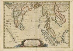
1698 Mercator Ptolemaic Map of Asia East of the Ganges
$901
$1,126.2520% Off
£670.61
£838.2720% Off
€752
€94020% Off
CA$1,234.15
CA$1,542.6920% Off
A$1,372.64
A$1,715.8120% Off
CHF 716.75
CHF 895.9420% Off
MX$16,703.62
MX$20,879.5320% Off
NOK 9,154.02
NOK 11,442.5320% Off
SEK 8,584.86
SEK 10,731.0720% Off
DKK 5,724.71
DKK 7,155.8920% Off
Shipping
Retrieving quote...The 1stDibs Promise:
Authenticity Guarantee,
Money-Back Guarantee,
24-Hour Cancellation
About the Item
**Catalogue Description:**
**Title:** Tab. XI. Asiae, comprehendens Indiam extra Gangem.
**Description:**
This is an exquisite Ptolemaic map depicting Asia east of the Ganges, titled "Tab. XI. Asiae, comprehendens Indiam extra Gangem." The map is adorned with a decorative cartouche, a compass rose, and several sailing ships traversing the seas. On land, detailed engravings of Bactrian camels, nomadic figures, and well-engraved elephants enrich the visual appeal of the map.
**Historical Context:**
This map is from the 1698 edition of Mercator’s Ptolemy Atlas, "Claudii Ptolemaei Tabulae Geographicae Orbis Terrarum Veteribus Cogniti," published by Francois Halma & Willem van den Water in Utrecht, and Leonard Strick in Franeker. The Atlas was initially published in 1578 and saw subsequent re-publications in 1584, 1605, 1618/1619, 1695, 1698, 1704, and 1730. For the 1698 edition, the plates were reworked with new cartouches and a new title engraving. Among all Ptolemaic editions, the Mercator editions are renowned for their superior execution and detail. Mercator aimed to create an Atlas of the classical world, serving as a historical companion to his modern atlas.
**Artists and Engravers:**
The map was created by Gerard Mercator (born Kremer), a prominent cartographer born in Rupelmonde, Flanders. He studied in Louvain and produced his first map in 1537, later becoming renowned for his cartography and globe-making. In 1552, Mercator relocated to Duisburg, Germany, where he published his famous 18-sheet world map in 1569, introducing the Mercator projection. He then decided to publish a new edition of Ptolemy’s Geographia, followed by his major work, a three-volume collection of maps. The first volume appeared in 1585, the second in 1589, and the third posthumously in 1595 by his son Rumold. A second edition of all three parts came out in 1602. In 1604, Jodocus Hondius acquired the plates, publishing several editions with his sons Jodocus II and Henricus until 1633. Further editions followed until 1666 by Janssonius in partnership with Henricus. Some of the plates were also used by W.J. Blaeu in 1630.
State: Revised 2nd state.
Publication Details:
- Publisher: Francois Halma & Willem van den Water (Utrecht) and Leonard Strick (Franeker)
- Date: 1698
- Source: Mercator’s Ptolemy Atlas
This map stands as a testament to the historical and geographical knowledge of the time, beautifully rendered by one of history's most influential cartographers, Gerard Mercator.
- Dimensions:Height: 16.93 in (43 cm)Width: 15.83 in (40.2 cm)Depth: 0.01 in (0.2 mm)
- Materials and Techniques:Paper,Engraved
- Period:1680-1689
- Date of Manufacture:1698
- Condition:Condition: Good given age. Original middle fold as issued. Some light creasing. A few tiny holes and some stains in upper blank margin. Please study the scans carefully.
- Seller Location:Langweer, NL
- Reference Number:Seller: BG-13741-11stDibs: LU3054340347052
About the Seller
5.0
Recognized Seller
These prestigious sellers are industry leaders and represent the highest echelon for item quality and design.
Platinum Seller
Premium sellers with a 4.7+ rating and 24-hour response times
Established in 2009
1stDibs seller since 2017
2,502 sales on 1stDibs
Typical response time: <1 hour
- ShippingRetrieving quote...Shipping from: Langweer, Netherlands
- Return Policy
Authenticity Guarantee
In the unlikely event there’s an issue with an item’s authenticity, contact us within 1 year for a full refund. DetailsMoney-Back Guarantee
If your item is not as described, is damaged in transit, or does not arrive, contact us within 7 days for a full refund. Details24-Hour Cancellation
You have a 24-hour grace period in which to reconsider your purchase, with no questions asked.Vetted Professional Sellers
Our world-class sellers must adhere to strict standards for service and quality, maintaining the integrity of our listings.Price-Match Guarantee
If you find that a seller listed the same item for a lower price elsewhere, we’ll match it.Trusted Global Delivery
Our best-in-class carrier network provides specialized shipping options worldwide, including custom delivery.More From This Seller
View AllRare and Very Old Antique Map of South East Asia, Published circa 1574
Located in Langweer, NL
A very fine impression of this map of the Malay Peninsula, Sumatra, Java, with Singapore denoted as 'Cinca Pula'.
Highly distorted and inaccurate map by Girolamo Ruscelli after J...
Category
Antique 16th Century Maps
Materials
Paper

$1,150 Sale Price
20% Off
Free Shipping
Map of Southeast Asia, Extending from India to Tibet & Japan to New Guinea, 1640
Located in Langweer, NL
Antique map titled 'India quae Orientalis dicitur et Insulae adiacentes'.
Map of Southeast Asia, extending from India to Tibet to Japan to New Guinea. This map is one of the firs...
Category
Antique 1640s Maps
Materials
Paper
$2,540 Sale Price
20% Off
1654 Nicolas Sanson Map of Southern India and Southeast Asia
Located in Langweer, NL
1654 Nicolas Sanson Map of Southern India and Southeast Asia - Partie Meridionale de L'Inde
This 1654 map by Nicolas Sanson, titled "Partie Meridionale de L'Inde en deux Presqu'Is...
Category
Antique 1650s Maps
Materials
Paper
Antique Map of India as Described It Was before the 5th Century, 1744
Located in Langweer, NL
Antique map titled 'India, as described by all Authors before the fifth Century'. Detailed map of part of India, including Hyrcania, Parthia, Carmania, Gedorossii, Drangiana, Aria, M...
Category
Antique 18th Century Maps
Materials
Paper

$306 Sale Price
20% Off
Antique Map of India and Southeast Asia by Sanson '1654'
Located in Langweer, NL
Antique map titled 'Partie Meridionale de l'Inde'. Early map of India and Southeast Asia. The map shows most of modern India, Bangladesh and Burma, the whole of Sri Lanka, Thailand, ...
Category
Antique Mid-17th Century Maps
Materials
Paper

$1,150 Sale Price
20% Off
Antique Map of Asia with Misshaped Coastlines and Distorted Islands c.1760
Located in Langweer, NL
Antique map titled 'L’Asie la feuille exc'. Old map of Asia. The map contains several misshaped coastlines and distorted islands with a small cartouche held by an elephant in the top...
Category
Antique 18th Century Maps
Materials
Paper
$133 Sale Price
20% Off
You May Also Like
Antique 1803 Italian Map of Asia Including China Indoneseia India
Located in Amsterdam, Noord Holland
Antique 1803 Italian Map of Asia Including China Indoneseia India
Very nice map of Asia. 1803.
Additional information:
Type: Map
Country of Manufacturing: Europe
Period: 19th centu...
Category
Antique 19th Century European Maps
Materials
Paper

$584 Sale Price
20% Off
Antique French Map of Asia Including China Indoneseia India, 1783
Located in Amsterdam, Noord Holland
Very nice map of Asia. 1783 Dedie au Roy.
Additional information:
Country of Manufacturing: Europe
Period: 18th century Qing (1661 - 1912)
Condition: Overall Condition B (Good Used)...
Category
Antique 18th Century European Maps
Materials
Paper

$648 Sale Price
20% Off
1627 Hendrik Hondius Map Entitled "Vltoniae Orientalis Pars, " Ric.a009
Located in Norton, MA
1627 Hendrik Hondius map entitled
"Vltoniae orientalis pars,"
Ric.a009
Title:
Vltoniae orientalis : pars
Title (alt.) :
Ultoniae orientalis pars
Creator:
Mercator, Gerh...
Category
Antique 17th Century Dutch Maps
Materials
Paper

Engraving Depicting 16th Century Map of Terra Sancta
Located in Buchanan, MI
Abraham Ortelius (Flemish, 1527-1598) Terra Sancta.
Engraving depicting 16th century map of Terra Sancta. Site 15" x 19.5.
Category
Antique 18th Century and Earlier Maps
Materials
Paper

1590 Mercator Map Entitled "France Picardie Champaigne, Ric.0001
Located in Norton, MA
Description: Published in Amsterdam by Mercator/Hondius ca. 1590.
Ric.0001
Artists and Engravers: Map : 'France Picardie Champaigne cum regionibus adiacentibus'. (Map of the french provinces of Picardie and Champagne.) Copper engraved map of the french provinces of Picardie and Champagne, showing the cities of Caen, Paris, Melun, Auxerre, Verdun, etc. Copperplate engraving on verge type hand laid paper with watermark. Description: Published in Amsterdam by Mercator/Hondius ca. 1600.Artists and Engravers: Mercator was born in Rupelmonde in Flanders and studied in Louvain under Gemma Frisius, Dutch writer, astronomer and mathematician. The excellence of his work brought him the patronage of Charles V, but in spite of his favor with the Emperor he was caught up in the persecution of Lutheran protestants and charged with heresy, fortunately without serious consequences. No doubt the fear of further persecution influenced his move in 1552 to Duisburg, where he continued the production of maps, globes and instruments. Mercator's sons and grandsons, were all cartographers and made their contributions in various ways to his atlas. Rumold, in particular, was responsible for the complete edition in 1595. The map plates...
Category
Antique 16th Century Dutch Maps
Materials
Paper

Antique Map - Mare Pacificum - Etching by Johannes Janssonius - 1650s
By Johannes Janssonius
Located in Roma, IT
Mare Pacificum is an antique map realized in 1650 by Johannes Janssonius (1588-1664).
The Map is Hand-colored etching, with coeval watercolorang.
Good conditions with slight foxing...
Category
1650s Modern Figurative Prints
Materials
Etching

More Ways To Browse
Antique Globes On Stands
World Globe On Stand
Francois Gerard
Camel Plate
Bactrian Camel
Antique Oushak Carpets
Blue Coffee Tables
1945 Chair Juhl
Antique Three Leg Table
Folke Arstrom
Silver Over Copper
Vintage Barware Glasses
Antique Etched Glass
Antique French Shell
Coffee Table Black Italian Modern
Christofle America
Iranian Silk Rug Carpet
Poul Moller