Items Similar to 1709 Map of the Holy Land - Twelve Tribes of Israel, Hand-Colored, Antique Map


Want more images or videos?
Request additional images or videos from the seller
1 of 7
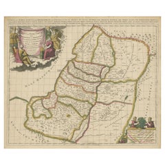
1709 Map of the Holy Land - Twelve Tribes of Israel, Hand-Colored, Antique Map
$1,964.96
£1,462.78
€1,640
CA$2,691.50
A$2,993.53
CHF 1,563.13
MX$36,428.11
NOK 19,963.55
SEK 18,722.29
DKK 12,484.75
Shipping
Retrieving quote...The 1stDibs Promise:
Authenticity Guarantee,
Money-Back Guarantee,
24-Hour Cancellation
About the Item
This is a beautiful 1709 map of the Holy Land, titled "Iudaea seu Terra Sancta quae Hebraeorum sive Israelitarum in suas duodecim Tribus divisa," by Guillaume Sanson and Alexis Hubert Jaillot. It highlights the Twelve Tribes of Israel based on Biblical references.
Below is a more detailed description and background information for this map:
Title: Judaea, or the Holy Land, Divided into the Twelve Tribes of the Hebrews or Israelites.
Cartographers:
- Guillaume Sanson (1633–1703): Son of Nicolas Sanson, a pioneer of French cartography, Guillaume contributed significantly to advancing his father’s legacy.
- Alexis Hubert Jaillot (c.1632–1712): A French mapmaker renowned for collaborating with Guillaume to re-engrave and enhance Nicolas Sanson’s works.
Publisher:
Hubert Jaillot, Paris, 1709.
Dimensions:
- Plate Size: Approximately 50 x 60 cm (19.7 x 23.6 inches).
---
Description:
This richly detailed, hand-colored map presents the biblical Holy Land as divided among the Twelve Tribes of Israel. It reflects the geographical understanding of the late 17th century and is based on Nicolas Sanson’s original map, updated and expanded by Guillaume Sanson and re-engraved by Alexis Hubert Jaillot.
Key features of the map include:
- Detailed boundaries of the Twelve Tribes, each identified with Latin inscriptions.
- The Mediterranean ("Mare Magnum seu Occidentale") on the left and the Dead Sea ("Lacus Asphaltites") towards the southeast.
- A stunning title cartouche at the top left, featuring ornate decorations, religious motifs, and symbols of Biblical significance.
- A scale and explanatory cartouche at the lower right, flanked by lions and additional decorative elements.
The collaboration between Sanson and Jaillot resulted in an elegant blend of artistry and precision, making this map both a geographical and decorative masterpiece.
---
Background Information:
This map serves as a significant historical artifact, blending religious, biblical, and cartographic traditions. The Sanson family, led by Nicolas and succeeded by Guillaume, laid the foundations of French cartography, producing maps that balanced accuracy with aesthetic appeal. Jaillot, a contemporary of Guillaume, refined these maps further, making them suitable for larger atlases aimed at royal and scholarly patrons.
The map’s basis on Biblical geography provides a snapshot of the Holy Land as interpreted through 17th-century Christian scholarship. It holds particular value for collectors interested in antique maps with religious and historical themes.
---
Condition: The map is in very good condition for its age, with vibrant original hand-coloring and minor signs of age-toning and edge wear. Both cartouches are crisp and well-preserved, enhancing the map’s visual appeal.
---
Keywords:
- Holy Land map
- Twelve Tribes of Israel
- Biblical cartography
- Guillaume Sanson map
- Alexis Hubert Jaillot map
- Antique French map
- Judaea map
- 17th-century geography
- Decorative cartouche
- Religious artifact
- Dimensions:Height: 15.75 in (40 cm)Width: 19.69 in (50 cm)Depth: 0.01 in (0.2 mm)
- Materials and Techniques:Paper,Engraved
- Period:1700-1709
- Date of Manufacture:1709
- Condition:Condition: The map is in excellent condition for its age, with vibrant original hand-coloring and minor signs of age-toning, foxing and edge wear. Both cartouches are crisp and well-preserved, enhancing the map’s visual appeal. Fold line as issued.
- Seller Location:Langweer, NL
- Reference Number:Seller: BG-14040-71stDibs: LU3054343431922
About the Seller
5.0
Recognized Seller
These prestigious sellers are industry leaders and represent the highest echelon for item quality and design.
Platinum Seller
Premium sellers with a 4.7+ rating and 24-hour response times
Established in 2009
1stDibs seller since 2017
2,510 sales on 1stDibs
Typical response time: <1 hour
- ShippingRetrieving quote...Shipping from: Langweer, Netherlands
- Return Policy
Authenticity Guarantee
In the unlikely event there’s an issue with an item’s authenticity, contact us within 1 year for a full refund. DetailsMoney-Back Guarantee
If your item is not as described, is damaged in transit, or does not arrive, contact us within 7 days for a full refund. Details24-Hour Cancellation
You have a 24-hour grace period in which to reconsider your purchase, with no questions asked.Vetted Professional Sellers
Our world-class sellers must adhere to strict standards for service and quality, maintaining the integrity of our listings.Price-Match Guarantee
If you find that a seller listed the same item for a lower price elsewhere, we’ll match it.Trusted Global Delivery
Our best-in-class carrier network provides specialized shipping options worldwide, including custom delivery.More From This Seller
View All1718 Holy Land Map - Twelve Tribes, Six Provinces, Hand-Colored, Antique Map
Located in Langweer, NL
Title: Terra Sancta in XII olim Tribus nunc VI Provincias Dispertita
Cartographer: Christoph Weigel the Elder (1654–1725)
Publisher: Johann Ernst Adelbulner
Publication Locatio...
Category
Antique 1710s Maps
Materials
Paper

Highly Detailed Antique Map of the Holy Land Showing 12 Tribes of Israel, c.1720
Located in Langweer, NL
Antique map titled 'Heylige Land verdeeld in de Twaalf Stammen Israels (..).'
Highly detailed map of the Holy Land divided into 12 tribes of Israel...
Category
Antique 1720s Maps
Materials
Paper

$460 Sale Price
20% Off
Free Shipping
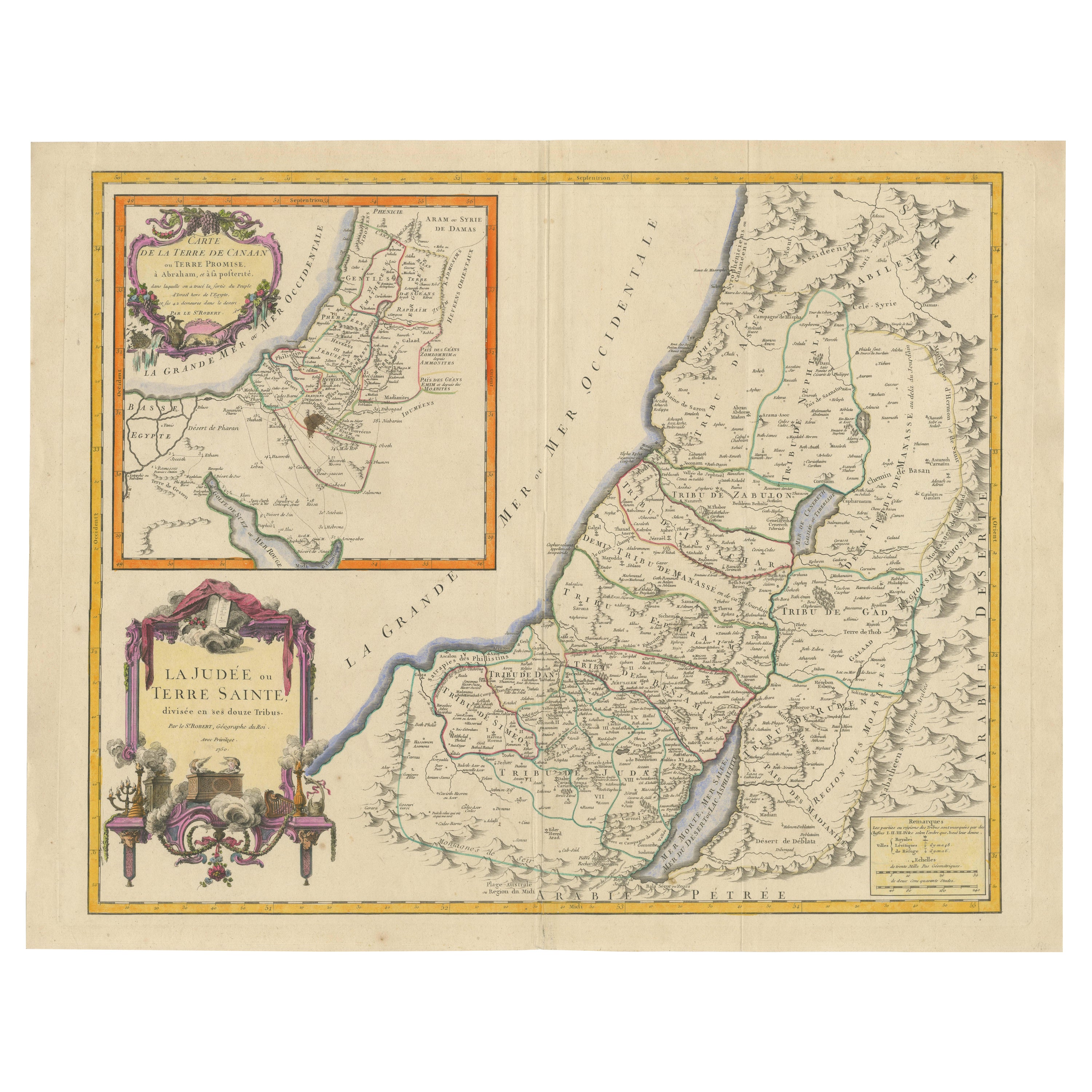
1750 Map of the Holy Land: The Land of Canaan and the Twelve Tribes
Located in Langweer, NL
Carte de la Terre de Canaan ou Terre Promise
Cartographer: Le St. Robert
Date of Publication: 1750
This exquisite 18th-century map, 'Carte de la Terre de Canaan ou Terre Promise', w...
Category
Antique 1750s Maps
Materials
Paper

1732 Henri Chatelain Map of the Holy Land Divided Among the Tribes of Israel
Located in Langweer, NL
Title: 1732 Henri Chatelain Map of the Holy Land Divided Among the Tribes of Israel
This exquisite 18th-century map by Henri Chatelain, published in 1732, offers a detailed depict...
Category
Antique 1710s Maps
Materials
Paper

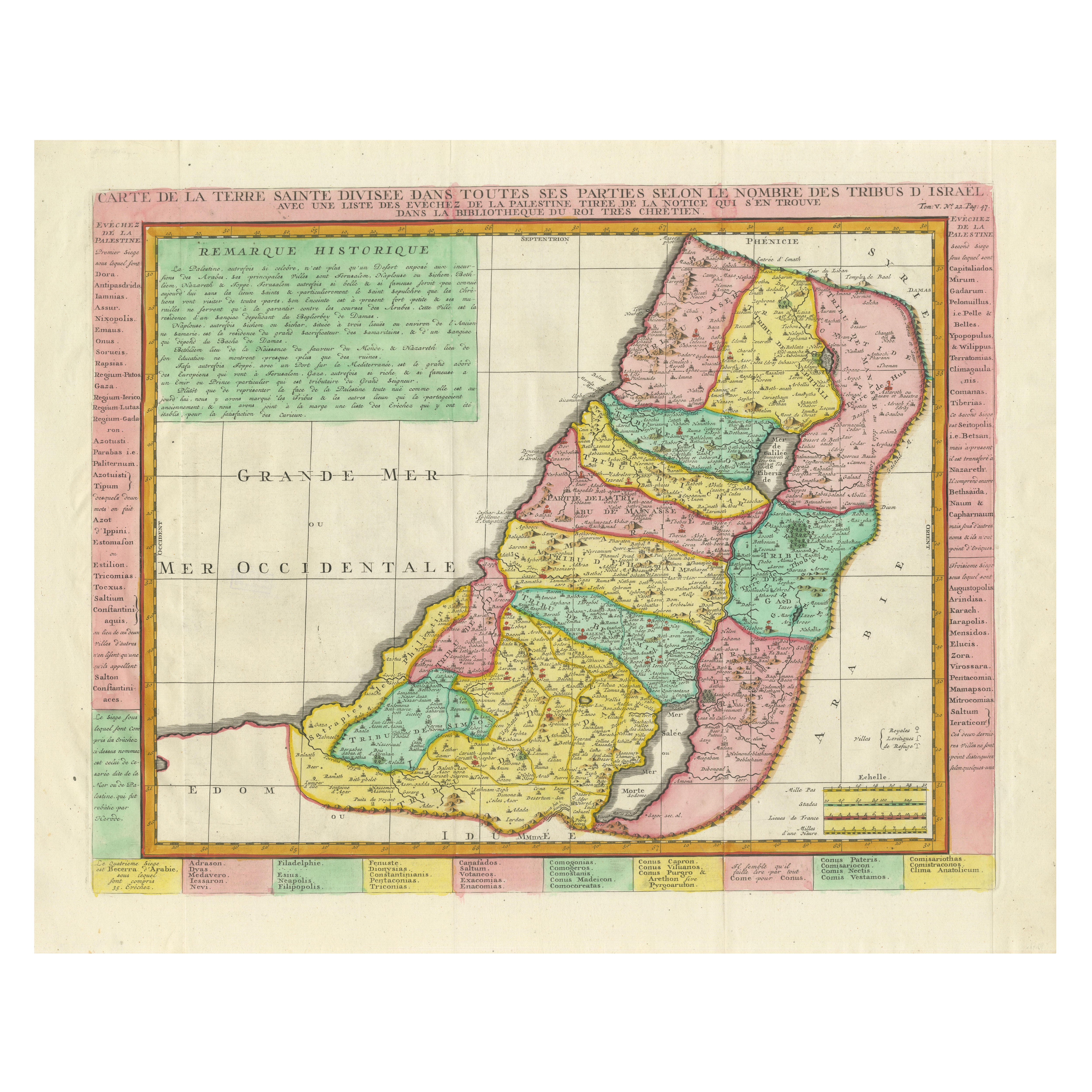
Antique Map of the Holy Land, Showing the Location of the Various Tribes
Located in Langweer, NL
Antique map titled 'Judaea seu Terra Sancta quae Hebraeorum sive Israelitarum (..)'. Map of The Holy Land, showing the location of the various tribes, in two kingdoms, Judah and Isra...
Category
Antique Early 18th Century Maps
Materials
Paper
$1,150 Sale Price
20% Off
Free Shipping
Antique Map of the Holy Land by Van Luchtenburg, c.1720
Located in Langweer, NL
Antique map titled 'Heylige Land verdeeld in de Twaalf Stammen Israels (..).' Highly detailed map of the Holy Land divided into 12 tribes of Israel...
Category
Antique 18th Century Maps
Materials
Paper

$134 Sale Price
20% Off
You May Also Like
"Nova Barbariae Descriptio", a 17th Century Hand-Colored Map of North Africa
By Johannes Janssonius
Located in Alamo, CA
This original attractive 17th century hand-colored map of North Africa entitled "Nova Barbariae Descriptio" by Johannes Janssonius was published in Paris in 1635. It includes the Med...
Category
Antique Mid-17th Century Dutch Maps
Materials
Paper

Prussia, Poland, N. Germany, Etc: A Hand-colored 17th Century Map by Janssonius
By Johannes Janssonius
Located in Alamo, CA
This is an attractive hand-colored copperplate engraved 17th century map of Prussia entitled "Prussia Accurate Descripta a Gasparo Henneberg Erlichensi", published in Amsterdam by Joannes Janssonius in 1664. This very detailed map from the golden age of Dutch cartography includes present-day Poland, Latvia, Lithuania, Estonia and portions of Germany. This highly detailed map is embellished by three ornate pink, red, mint green and gold...
Category
Antique Mid-17th Century Dutch Maps
Materials
Paper

Southern Greece: A Large 17th Century Hand-colored Map By Sanson and Jaillot
By Nicholas Sanson d'Abbeville
Located in Alamo, CA
This large original hand-colored copperplate engraved map of southern Greece and the Pelopponese Peninsula entitled "La Moree Et Les Isles De Zante, Cefalonie, Ste. Marie, Cerigo & C...
Category
1690s Landscape Prints
Materials
Engraving

1633 Map "La Souverainete De Sedan Et De Raucourt, Et La Prevoste Ric0011
Located in Norton, MA
1653 map entitled
"La Souverainete de Sedan et de Raucourt, et la Prevoste de Doncheri,"
Ric0011
Description:
Lovely map centered on Sedan and Doncheri and the Meuze River fr...
Category
Antique 17th Century Dutch Maps
Materials
Paper

1630 Pierre Petit map "Description du Gouvernement de la Capelle" Ric0010
Located in Norton, MA
1630 Pierre Petit map entitled
"Description du Gouvernement de la Capelle,"
Ric0010
Pierre Petit was the son of a minor provincial official in Montluçon. The town, in the Auver...
Category
Antique 17th Century Dutch Maps
Materials
Paper

17th Century Hand-Colored Map of a Region in West Germany by Janssonius
By Johannes Janssonius
Located in Alamo, CA
This attractive highly detailed 17th century original hand-colored map is entitled "Archiepiscopatus Maghdeburgensis et Anhaltinus Ducatus cum terris adjacentibus". It was published ...
Category
Antique Mid-17th Century Dutch Maps
Materials
Paper

More Ways To Browse
Carlo Scarpa 1934 Chairs
Christofle Marly
1900 Antique Chairs
Glass Table Italian Round
Alvar Aalto Poster
Geometric Metal Table
Post Modern High Chairs
Vintage Vine Rug
Cancel An Order
Antique Framing Square
Silver Metal Chair
Swedish Kilim
Vintage Scandanavian Chairs
Vintage Tropical Furniture
19th Century Red Glass
Antique French Console Table Tables
French 50s
Rusted Metal Art