Items Similar to 1630 Pierre Petit map "Description du Gouvernement de la Capelle" Ric0010

Want more images or videos?
Request additional images or videos from the seller
1 of 12
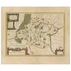
1630 Pierre Petit map "Description du Gouvernement de la Capelle" Ric0010
About the Item
1630 Pierre Petit map entitled
"Description du Gouvernement de la Capelle,"
Ric0010
Pierre Petit was the son of a minor provincial official in Montluçon. The town, in the Auvergne region of central France, is situated northwest of Clermont-Ferrand. The old town in which Pierre was brought up was on a hill dominated by a château. After being educated in Montluçon he followed his father into local government and spent the first years of his adult life as 'contrôleur de l'election' in the town of his birth. As Petit was much involved in the government of France, we should look briefly at political events of the times in which he lived.
Louis XIII had become King of France in 1610, around the time Petit was thinking about a career in government. The fact that Louis XIII's father Henry IV had been assassinated by a fanatical Roman Catholic, and Louis was only nine years old when he succeeded to the throne, already gives some idea of the political situation. It was a time of revolt by the French peasants, and officials loyal to the government were in some danger of assassination.
In 1633 Petit moved to Paris to play a role in national rather than local government. Being in Paris had another advantage for Petit since it allowed him to become more involved with men of science than he could be in a town like Montluçon. Richelieu, a major figure in the French government, had begun with a career in the Church and, as Bishop of Luçon, became involved with the government in the difficult period when Louis XIII was a minor. The King managed to get Richelieu made a Cardinal, then appointed him as secretary of state in 1624, giving him the title of first minister four years later. When Petit arrived in Paris in 1633 he was appointed 'Commissaire Provincial de l'Artillerie' by Richelieu.
In Paris Petit joined with the group of scientists meeting with Mersenne at the Minims de l'Annociade near Place Royale. In the year Petit arrived in Paris, Mersenne published Traité des mouvements, and in the following year he published Les Mécanique de Galilée which was a version of Galileo's lectures on mechanics. Étienne Pascal had arrived in Paris two years before Petit so that his son could have the best education. He and his son Blaise Pascal were also members of Mersenne's group as were others such as Gassendi, Roberval, and Beaugrand.
Petit was an influential figure with important government positions which enabled him to try to influence national science policy. A firm believer, as were the other members of Mersenne's group, of the experimental method rather than the philosophical approach advocated by Descartes, Petit argued strongly for better astronomical facilities in France. He wanted the King to establish a Royal Observatory to allow France to again take a leading role in astronomy. Petit argued that France had fallen behind some other European countries and was relying on observations made in other countries. Petit himself had a fine collection of astronomical instruments and several of these were of his own invention. In particular, late in his life, Petit devised a filar micrometer to measure the diameters of celestial objects such as the Sun, Moon and planets. By this time Petit was 'Intendant Général des Fortifications', a position he was appointed to in 1649, and he wrote a letter which describes the instrument. This was published in the Journal des sçavans in May 1667 as Extrait d'une lettre de M Petit Intendant des Fortifications ... touchant une nouvelle machine pour mesurer exactment les diamètres des astres. Petit's instrument was later used by Giovanni Cassini in the Royal Observatory in Paris.
Among many collaborations, Petit worked with Étienne Pascal and his son Blaise Pascal in October 1646 in repeating Torricelli's experiment on the barometric vacuum. Petit wrote an account of these experiments which were published as Observation touchant le vuide faite pour la première fois en France in 1647. Petit kept up a regular correspondence with the secretary of the Royal Society in London after its foundation in 1660 and was one of the first foreign fellows of that Society when elected in April 1667. Petit had written Dissertation sur la nature des comètes in 1665 which had been highly praised by the Royal Society and must have played a large role in him being elected a fellow.
Petit had argued strongly in favour of setting up an official scientific organisation in France so it is rather surprising that when the Académie des Sciences was founded in Paris in 1666 by Jean-Baptiste Colbert, at that time controller general of finance in France, Petit was not made a member. Colbert's programme of economic reconstruction was largely responsible for making France the leading power in Europe. There surely were personal reasons why Colbert, whose aims were so close to those of Petit, chose to ignore him when he drew up the initial list of members.
Dimension: Paper: 57 cm W x 48 cm H) ; Sight: 49 cm W x 37 cm H
Condition: Good Condition with some torn on the edge, please see photos.
- Dimensions:Height: 18.9 in (48 cm)Width: 22.45 in (57 cm)Depth: 0.4 in (1 cm)
- Materials and Techniques:
- Place of Origin:
- Period:
- Date of Manufacture:1630
- Condition:
- Seller Location:Norton, MA
- Reference Number:1stDibs: LU5848230174092
About the Seller
5.0
Platinum Seller
These expertly vetted sellers are 1stDibs' most experienced sellers and are rated highest by our customers.
Established in 2000
1stDibs seller since 2021
85 sales on 1stDibs
Typical response time: <1 hour
- ShippingRetrieving quote...Ships From: Norton, MA
- Return PolicyA return for this item may be initiated within 3 days of delivery.
More From This SellerView All
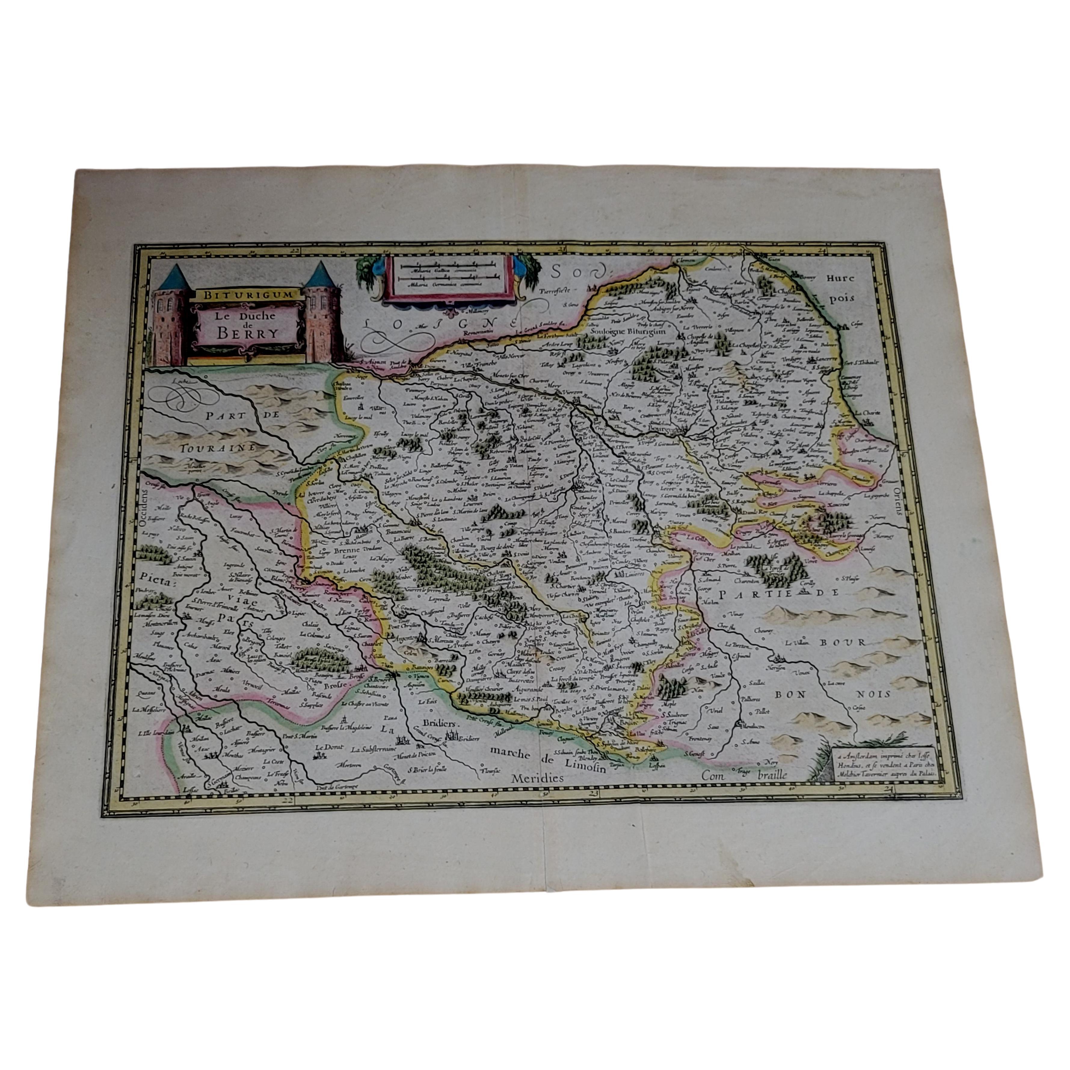
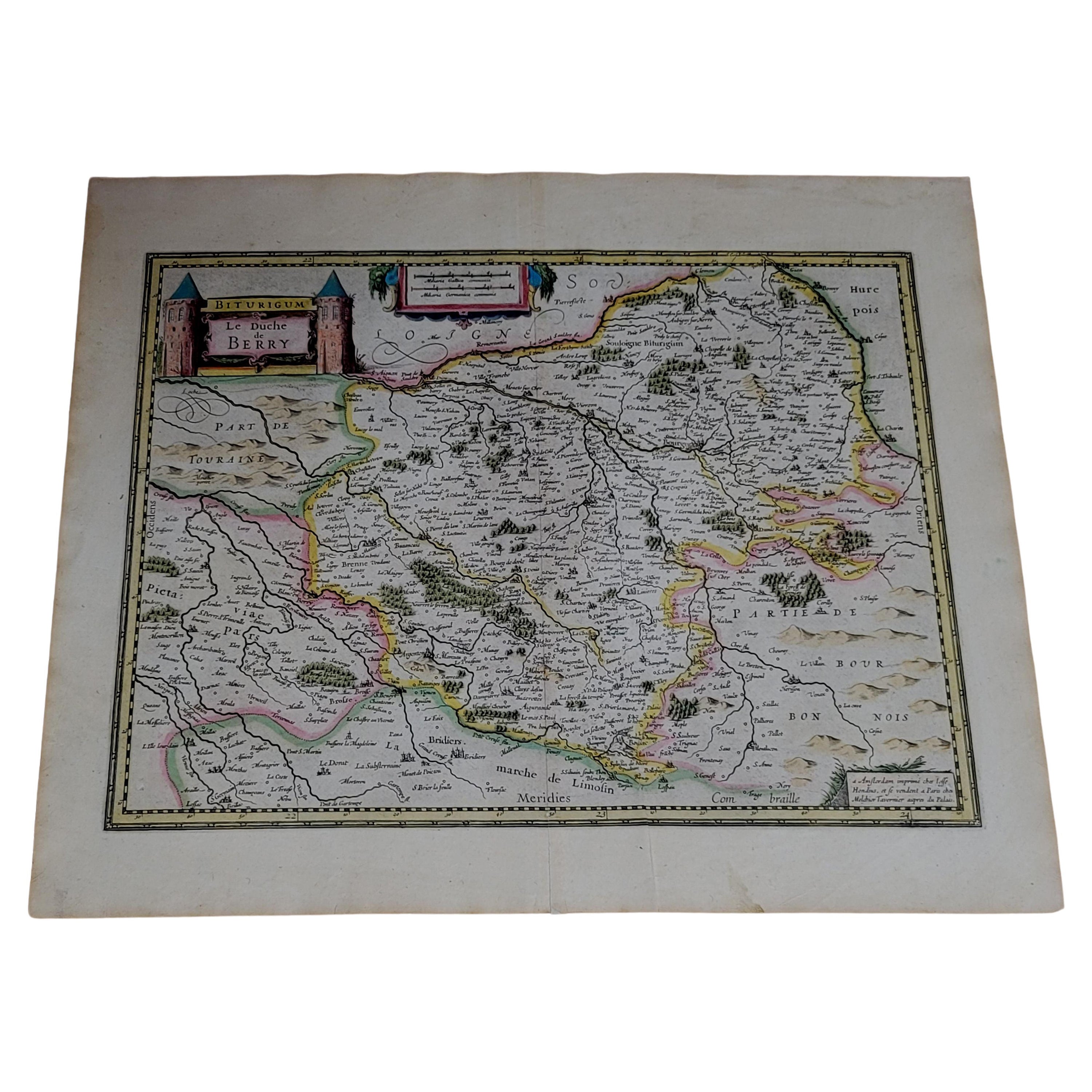
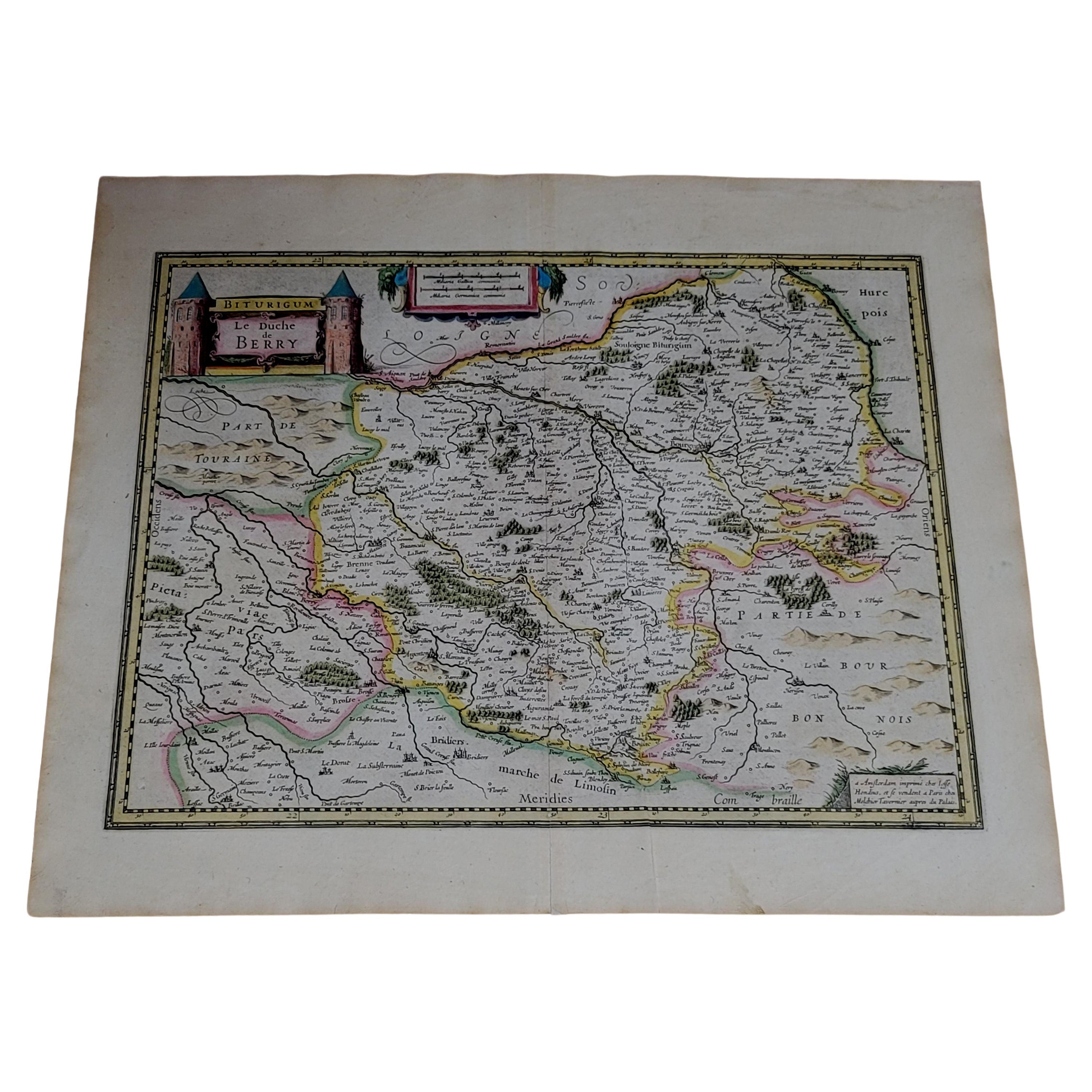
- 1633 Map, Entitled "La Douche De Berry, " Ric.0005Located in Norton, MA1633 map, entitled "La douche de Berry," Hand Colored Ric.0005 Description: 1633 map, entitled "La douche de Berry," Dimension: Paper: 23.3" W x 20.3" H (59 cm W x 51.7 c...Category
Antique 17th Century Unknown Maps
MaterialsPaper
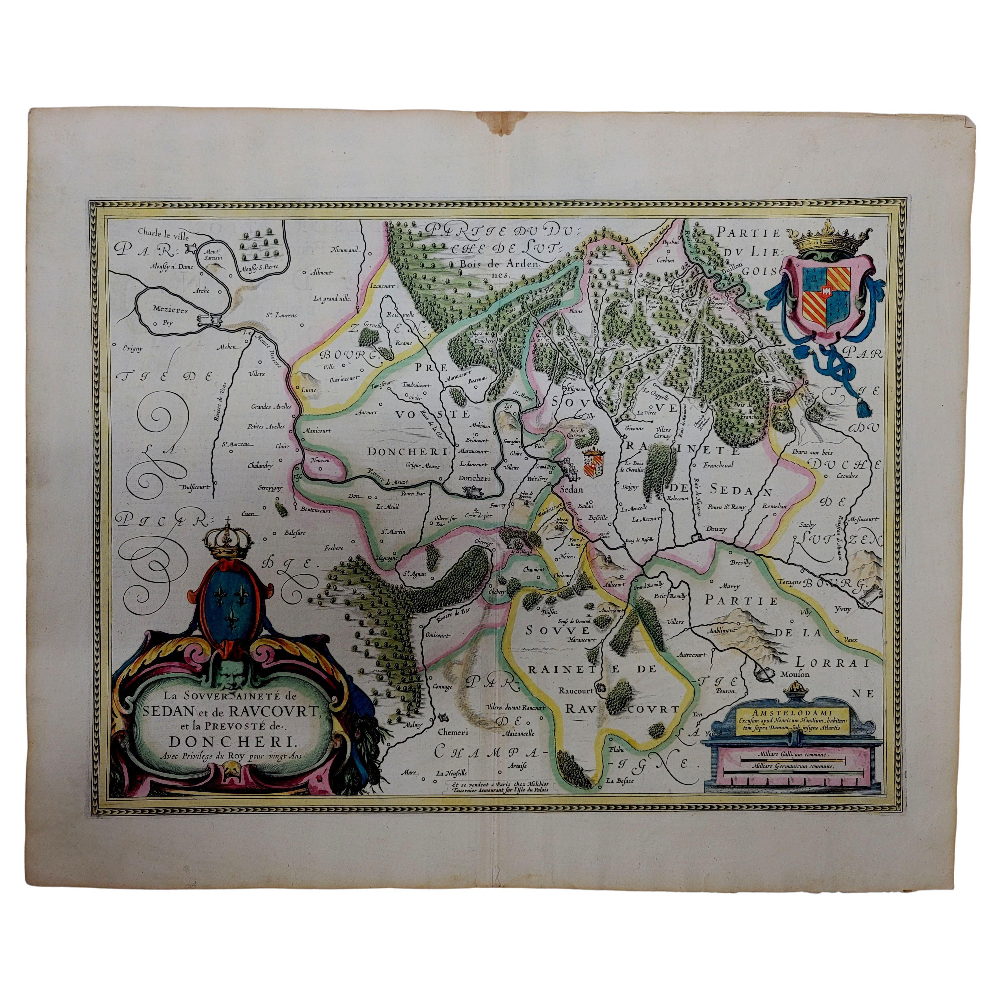
- 1633 Map "La Souverainete De Sedan Et De Raucourt, Et La Prevoste Ric0011Located in Norton, MA1653 map entitled "La Souverainete de Sedan et de Raucourt, et la Prevoste de Doncheri," Ric0011 Description: Lovely map centered on Sedan and Doncheri and the Meuze River fr...Category
Antique 17th Century Dutch Maps
MaterialsPaper
- 1633 map, entitled "La douche de Berry, " Original Hand Colored Ric.0005Located in Norton, MA1633 map, entitled "La douche de Berry," Hand Colored Ric.0005 Description: 1633 map, entitled "La douche de Berry," Dimension: Paper: 23.3" W x 20.3" H (59 cm W x 51.7 cm H) ; ...Category
Antique 17th Century Dutch Maps
MaterialsPaper
- 1633 Map, Entitled "La Douche De Berry, " Original Hand Colored Ric.0005Located in Norton, MA1633 map, entitled. "La douche de Berry," Hand Colored Ric.0005 Description: 1633 map, entitled "La douche de Berry,". Dimension: Paper: 23.3" W x 20.3" H (59 cm W x 51.7...Category
Antique 17th Century Unknown Maps
MaterialsPaper
- 1860 Large Map "Carte De La Siberie Russie D'asie, " Ric.R0001Located in Norton, MALarge 1860 map "Carte De La Siberie Russie D'Asie," R-0001 " Authentic" - 1860 map "Carte De La Siberie Russie D'Asie," Dimension: Paper: 68 cm W x 51 cm H ; Sight: 51cm W x 4...Category
Antique 19th Century Unknown Maps
MaterialsPaper
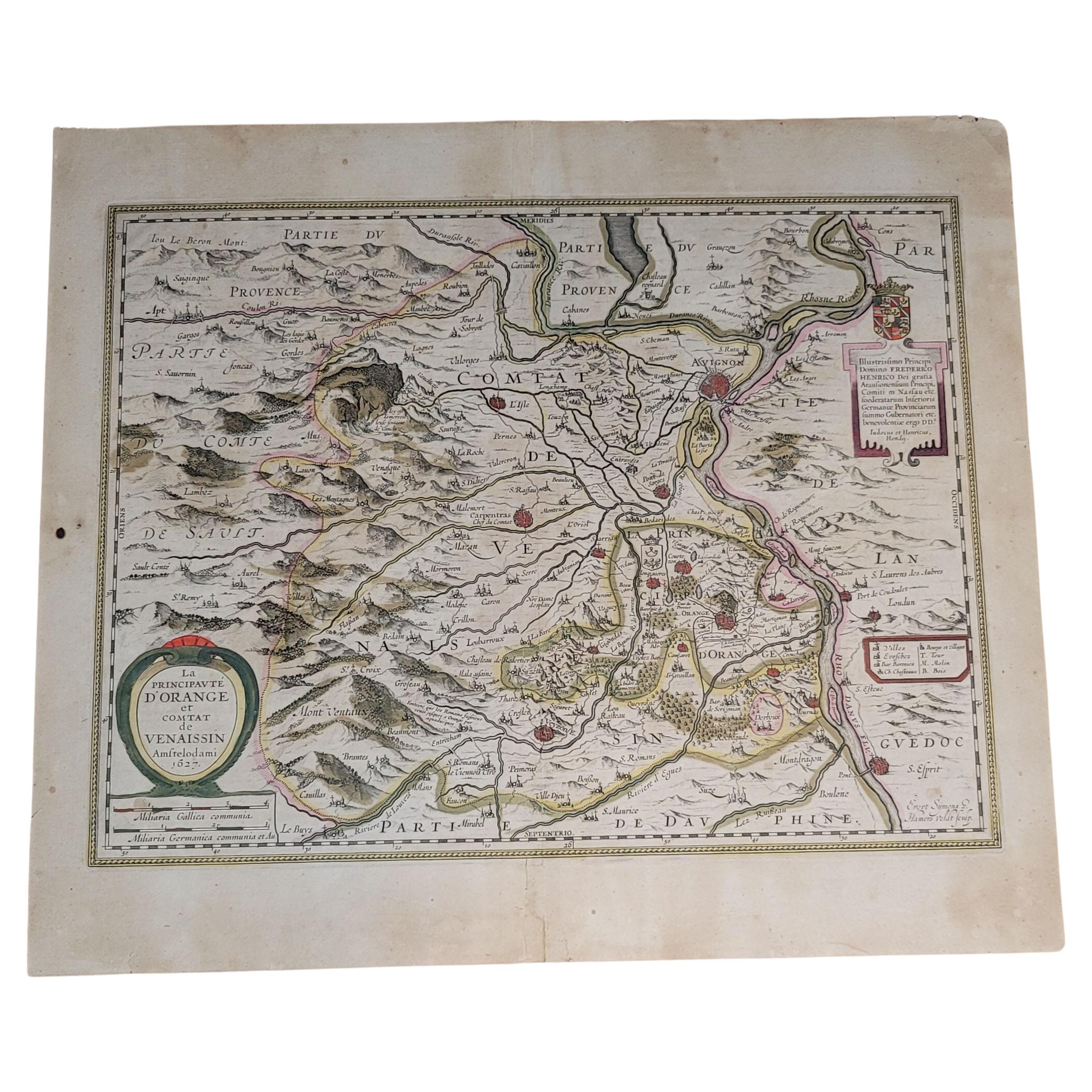
- 1627 Hondius Map "La Principaute d'Orange et Comtat de Ve", Ric.0003Located in Norton, MA1627 Hondius map entitled "La Principaute d'Orange et Comtat de Venaissin," Original Hand-Colored Description: From Johannes Janssonius's Atlantis Maioris Appendix of 1630. ...Category
Antique 17th Century Unknown Maps
MaterialsPaper


You May Also Like
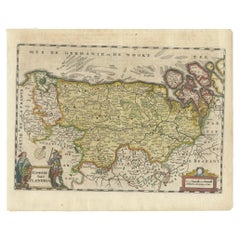
- Antique Map of Flanders, Belgium, 1630Located in Langweer, NLAntique map titled 'Comitatus Flandria'. Original antique map of Flanders, Belgium. This map originates from 'Vyerige Colom verthonende de 17 Nederlandsche Provintien' published 1630...Category
Antique 17th Century Maps
MaterialsPaper
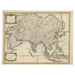
- Antique Map of Asia by Pierre du Val, '1663'Located in Langweer, NLAntique map titled 'L'Asie'. Antique map of the Asian continent by Pierre Duval, dated 1663. Most place names represent geographical entities that currently exist or once existed. The rendition of the lower islands of Japan and the peninsula of Korea are improved over earlier studies. Details of the Great Wall of China...Category
Antique Mid-17th Century Maps
MaterialsPaper
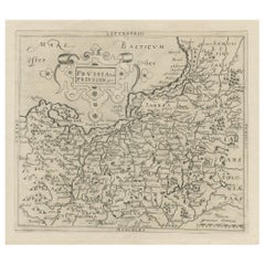
- Original Antique Map of Prussia, ca.1630Located in Langweer, NLAntique map titled 'Prussia - Preussen'. Original map of Prussia, a historically prominent German state that originated in 1525 with a duchy centered on...Category
Antique 1630s Maps
MaterialsPaper
- Map of the Holy Land "Carte de la Syrie et de l'Egypte" by Pierre M. LapieBy Pierre M. LapieLocated in Alamo, CAAn early 19th century map of ancient Syria and Egypt entitled "Carte de la Syrie et de l'Egypte anciennes/dressée par M. Lapie, Colonel d'Etat Major, et...Category
Antique Early 19th Century French Maps
MaterialsPaper
- Antique Map of the Region of Hauts-de-France by Hondius, circa 1630Located in Langweer, NLAntique map titled 'Description du Gouvernement de la Cappelle'. Old map of the region of Hauts-de-France including the cities of Vervins, Marle, Cappelle and others. This map origin...Category
Antique Mid-17th Century Maps
MaterialsPaper
- Antique Map of the Region of Île-de-France by Hondius, circa 1630Located in Langweer, NLAntique map titled Gouvernement de l'Isle de France'. Old map of the region of Île-de-France, France. It is located in the north-central part of the country and often called the régi...Category
Antique Mid-17th Century Maps
MaterialsPaper