Items Similar to 1860 Large Map "Carte De La Siberie Russie D'asie, " Ric.R0001
Want more images or videos?
Request additional images or videos from the seller
1 of 6
1860 Large Map "Carte De La Siberie Russie D'asie, " Ric.R0001
About the Item
Large 1860 map "Carte De La Siberie Russie D'Asie," R-0001
" Authentic" - 1860 map "Carte De La Siberie Russie D'Asie,"
Dimension: Paper: 68 cm W x 51 cm H ; Sight: 51cm W x 40 cm H
Condition: Good Condition with aged toning, please see photos.
- Dimensions:Height: 20.08 in (51 cm)Width: 26.78 in (68 cm)Depth: 0.4 in (1 cm)
- Materials and Techniques:
- Place of Origin:
- Period:
- Date of Manufacture:1860
- Condition:
- Seller Location:Norton, MA
- Reference Number:1stDibs: LU5848230265782
About the Seller
5.0
Platinum Seller
These expertly vetted sellers are 1stDibs' most experienced sellers and are rated highest by our customers.
Established in 2000
1stDibs seller since 2021
85 sales on 1stDibs
Typical response time: <1 hour
- ShippingRetrieving quote...Ships From: Norton, MA
- Return PolicyA return for this item may be initiated within 3 days of delivery.
More From This SellerView All
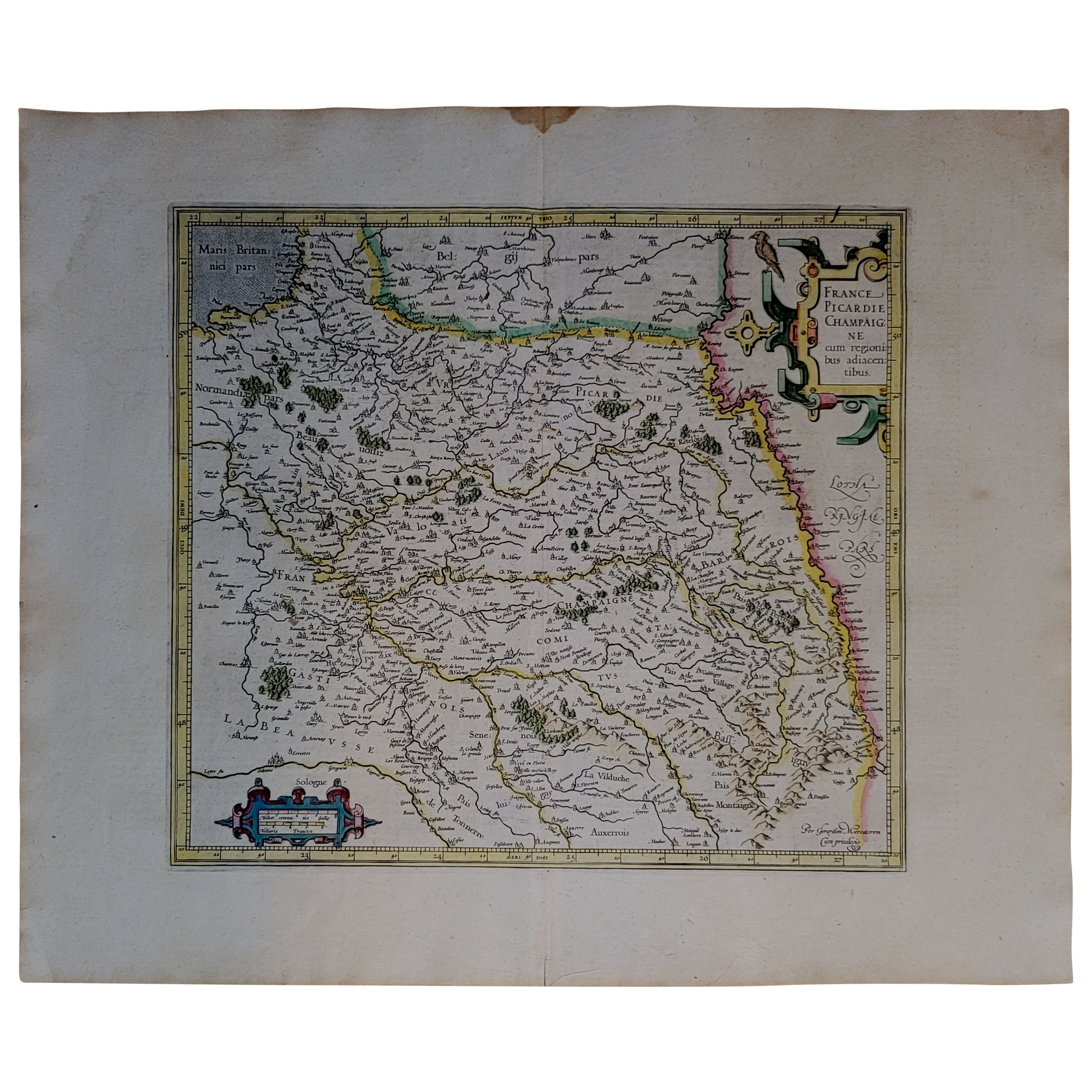
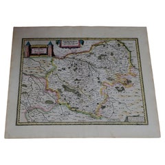
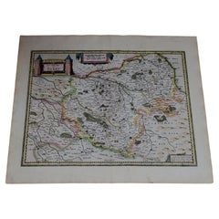
- 1590 Mercator Map Entitled "France Picardie Champaigne, Ric.0001Located in Norton, MADescription: Published in Amsterdam by Mercator/Hondius ca. 1590. Ric.0001 Artists and Engravers: Map : 'France Picardie Champaigne cum regionibus adiacentibus'. (Map of the french provinces of Picardie and Champagne.) Copper engraved map of the french provinces of Picardie and Champagne, showing the cities of Caen, Paris, Melun, Auxerre, Verdun, etc. Copperplate engraving on verge type hand laid paper with watermark. Description: Published in Amsterdam by Mercator/Hondius ca. 1600.Artists and Engravers: Mercator was born in Rupelmonde in Flanders and studied in Louvain under Gemma Frisius, Dutch writer, astronomer and mathematician. The excellence of his work brought him the patronage of Charles V, but in spite of his favor with the Emperor he was caught up in the persecution of Lutheran protestants and charged with heresy, fortunately without serious consequences. No doubt the fear of further persecution influenced his move in 1552 to Duisburg, where he continued the production of maps, globes and instruments. Mercator's sons and grandsons, were all cartographers and made their contributions in various ways to his atlas. Rumold, in particular, was responsible for the complete edition in 1595. The map plates...Category
Antique 16th Century Dutch Maps
MaterialsPaper
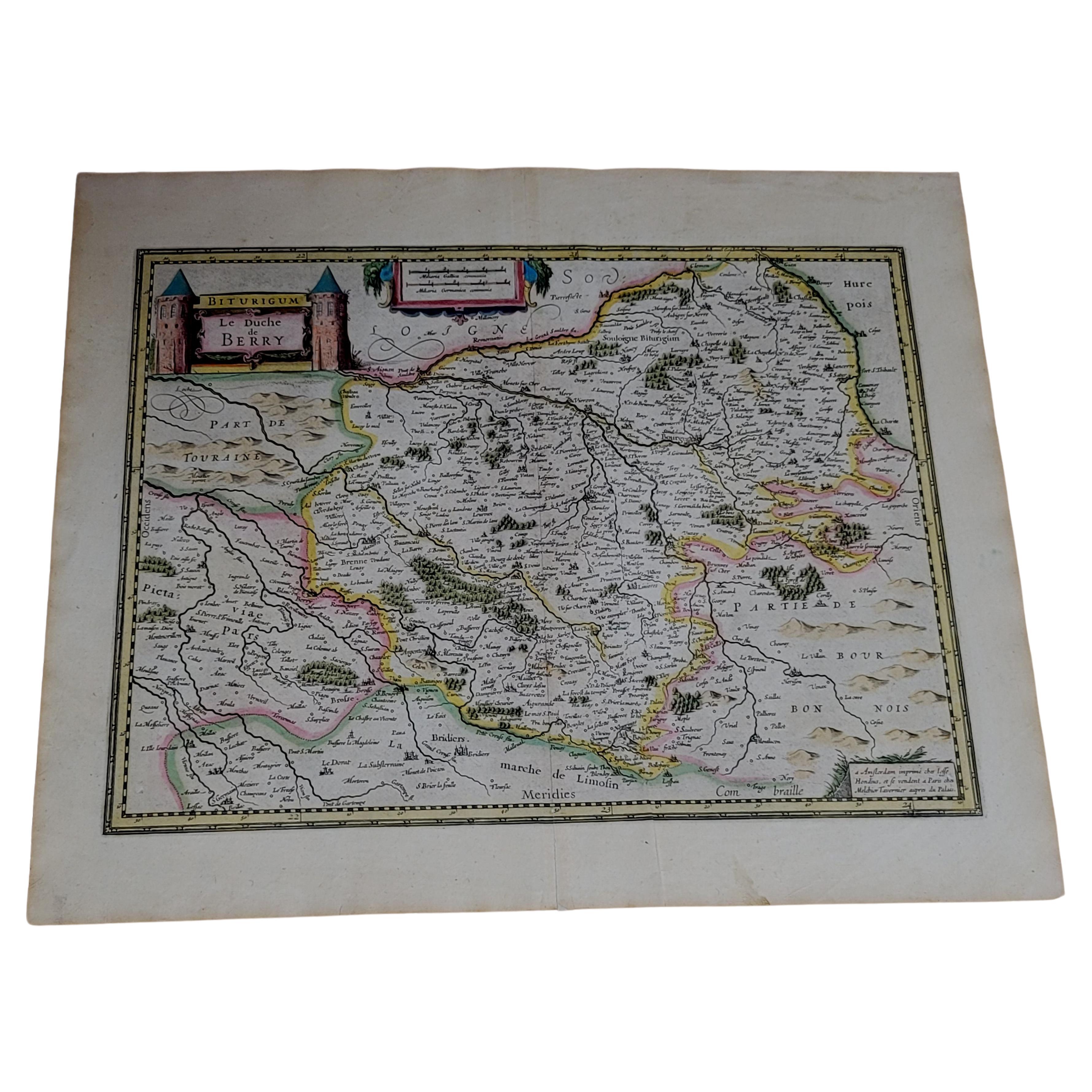
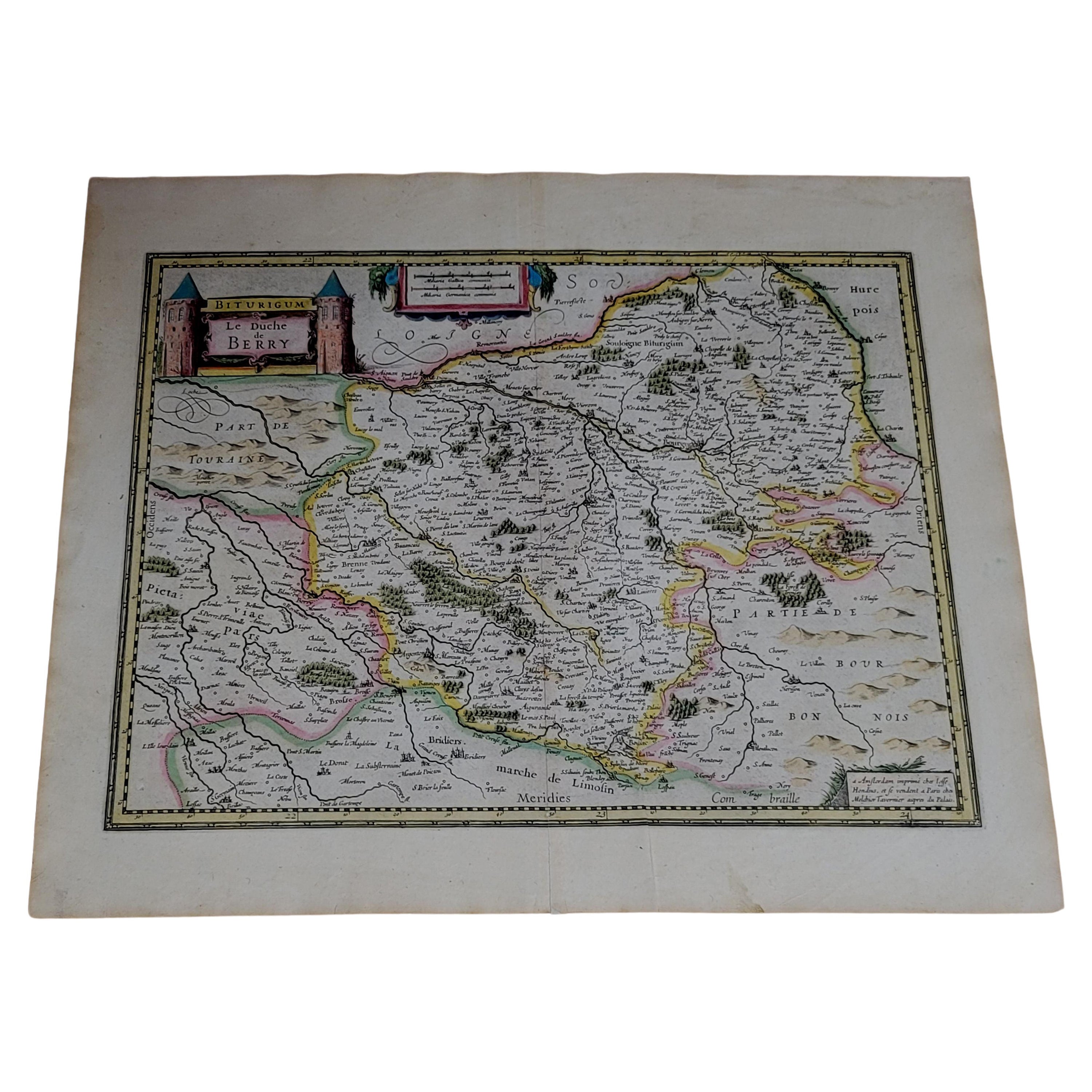
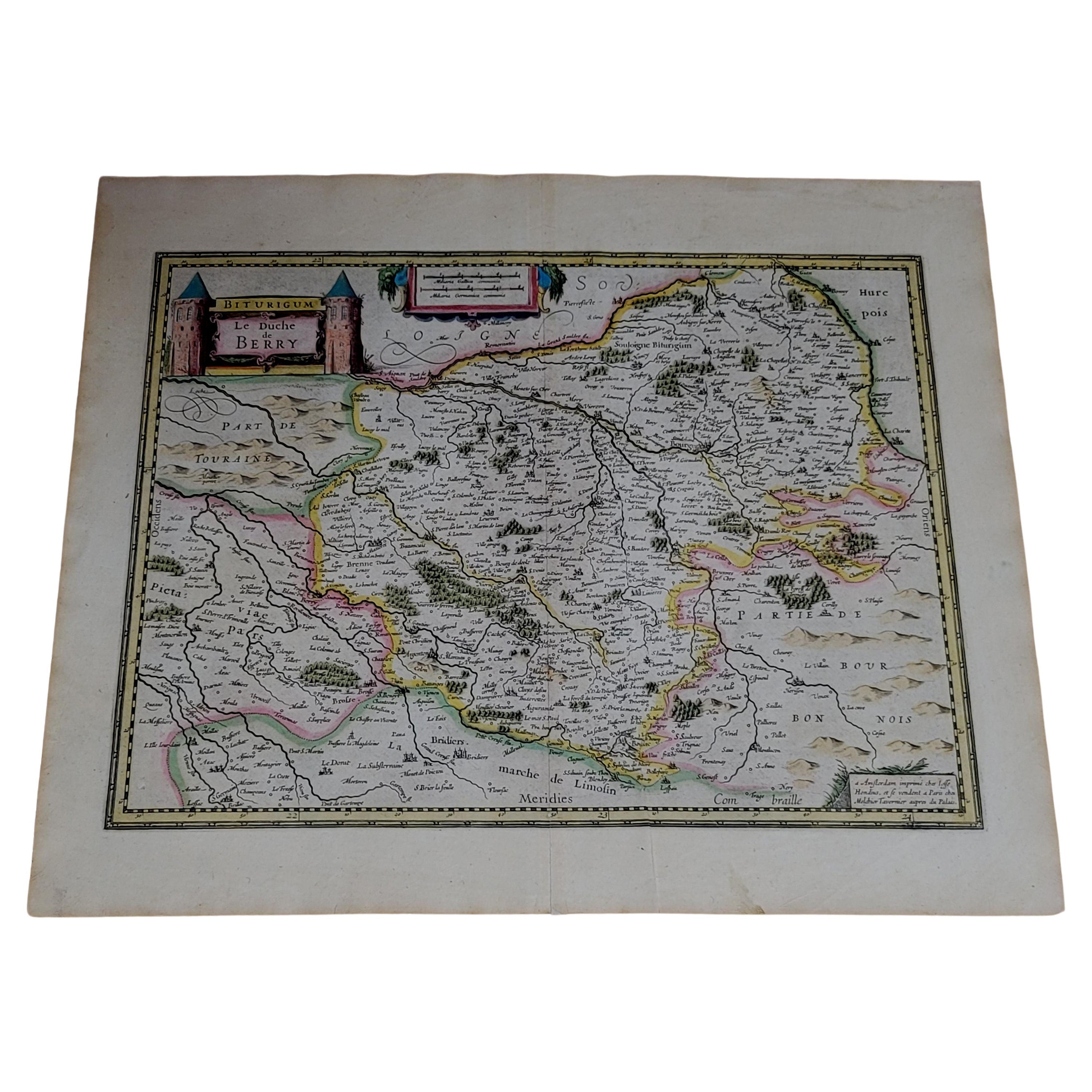
- 1633 Map, Entitled "La Douche De Berry, " Ric.0005Located in Norton, MA1633 map, entitled "La douche de Berry," Hand Colored Ric.0005 Description: 1633 map, entitled "La douche de Berry," Dimension: Paper: 23.3" W x 20.3" H (59 cm W x 51.7 c...Category
Antique 17th Century Unknown Maps
MaterialsPaper
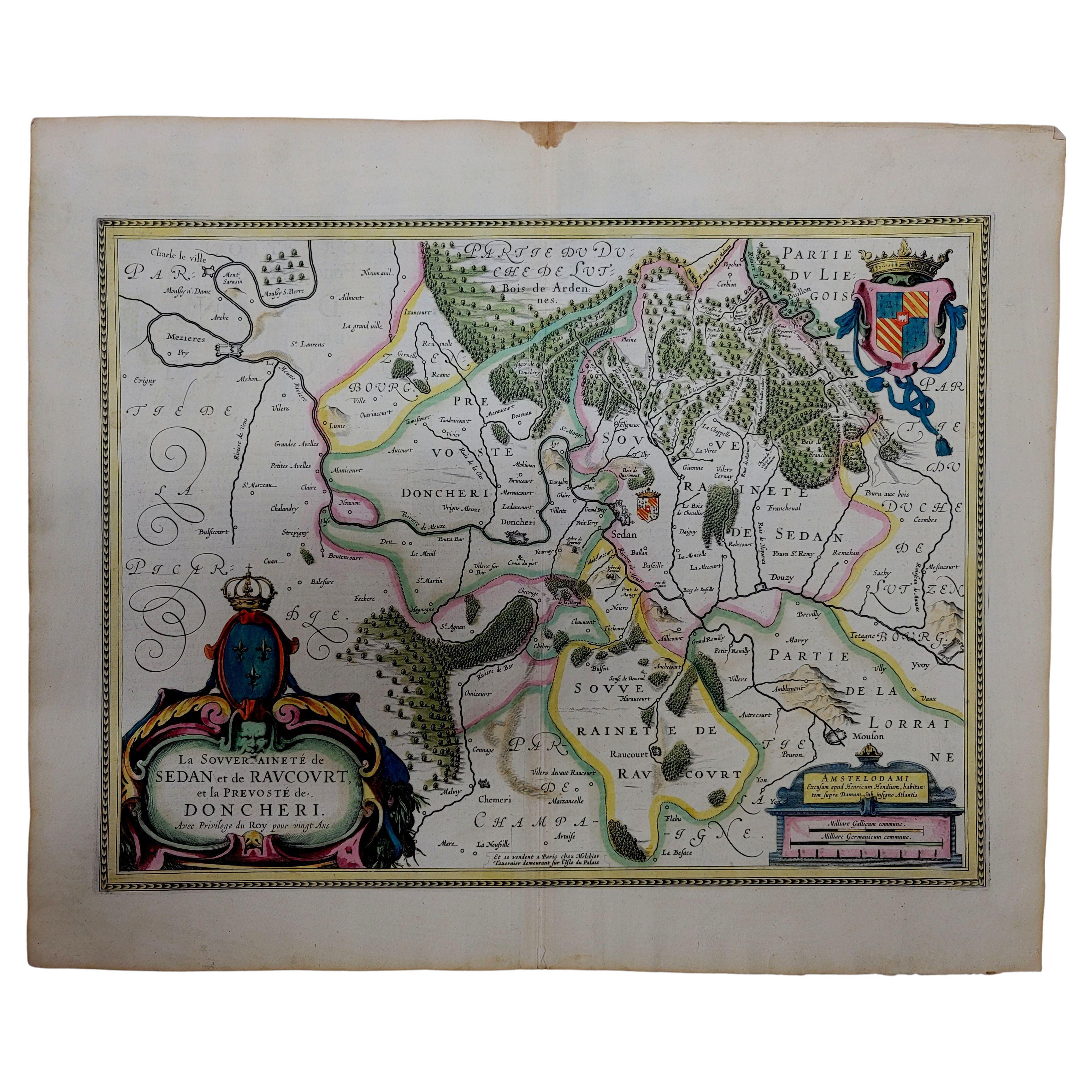
- 1633 Map "La Souverainete De Sedan Et De Raucourt, Et La Prevoste Ric0011Located in Norton, MA1653 map entitled "La Souverainete de Sedan et de Raucourt, et la Prevoste de Doncheri," Ric0011 Description: Lovely map centered on Sedan and Doncheri and the Meuze River fr...Category
Antique 17th Century Dutch Maps
MaterialsPaper
- 1633 map, entitled "La douche de Berry, " Original Hand Colored Ric.0005Located in Norton, MA1633 map, entitled "La douche de Berry," Hand Colored Ric.0005 Description: 1633 map, entitled "La douche de Berry," Dimension: Paper: 23.3" W x 20.3" H (59 cm W x 51.7 cm H) ; ...Category
Antique 17th Century Dutch Maps
MaterialsPaper
- 1633 Map, Entitled "La Douche De Berry, " Original Hand Colored Ric.0005Located in Norton, MA1633 map, entitled. "La douche de Berry," Hand Colored Ric.0005 Description: 1633 map, entitled "La douche de Berry,". Dimension: Paper: 23.3" W x 20.3" H (59 cm W x 51.7...Category
Antique 17th Century Unknown Maps
MaterialsPaper
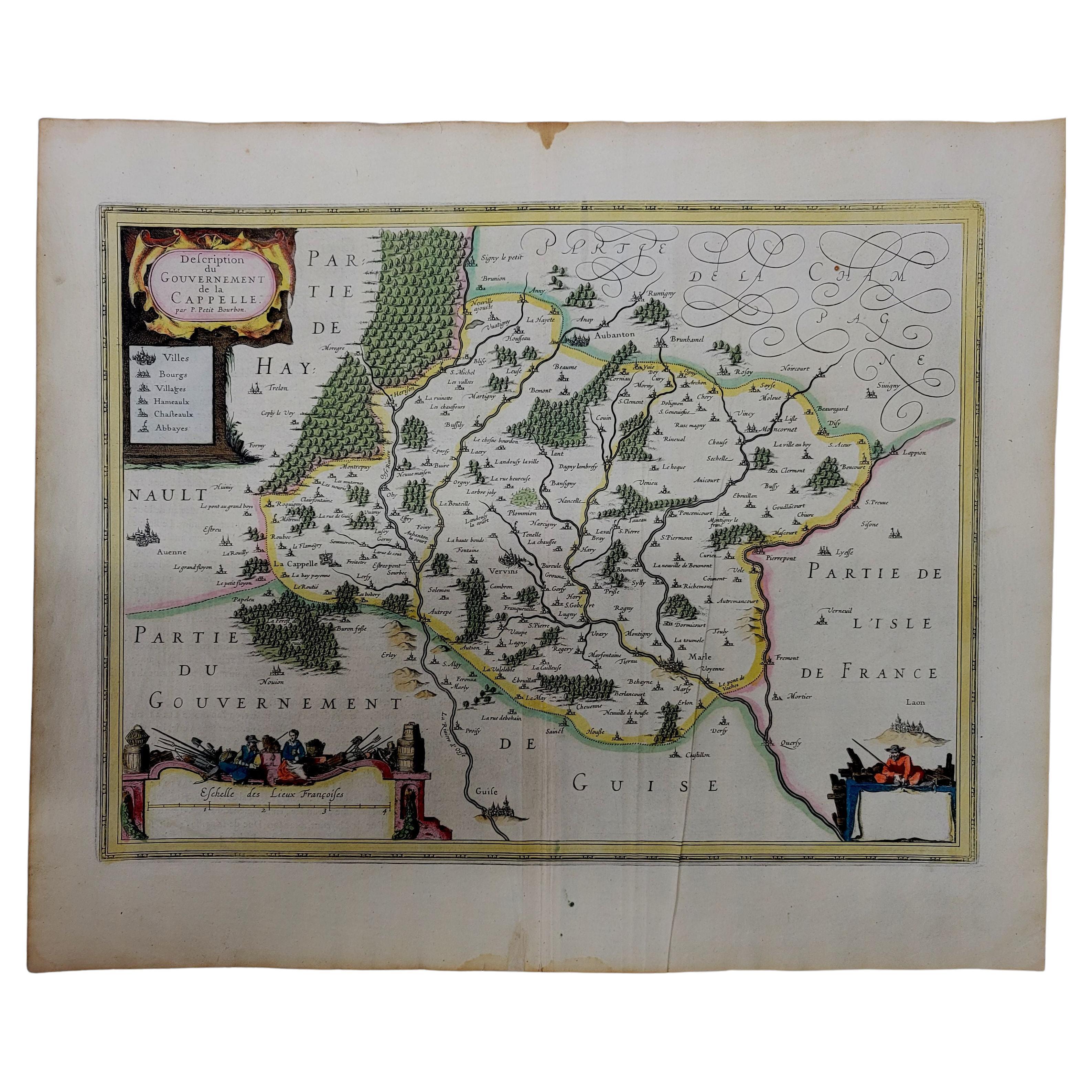
- 1630 Pierre Petit map "Description du Gouvernement de la Capelle" Ric0010Located in Norton, MA1630 Pierre Petit map entitled "Description du Gouvernement de la Capelle," Ric0010 Pierre Petit was the son of a minor provincial official in Montluçon. The town, in the Auver...Category
Antique 17th Century Dutch Maps
MaterialsPaper


You May Also Like
- Map of the Holy Land "Carte de la Syrie et de l'Egypte" by Pierre M. LapieBy Pierre M. LapieLocated in Alamo, CAAn early 19th century map of ancient Syria and Egypt entitled "Carte de la Syrie et de l'Egypte anciennes/dressée par M. Lapie, Colonel d'Etat Major, et...Category
Antique Early 19th Century French Maps
MaterialsPaper
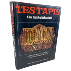
- Les Tapis d'Asie Centrale et du Kazakhstan, Rugs of Kazakhstan French Text BookLocated in North Hollywood, CAVintage Rugs of Kazakhstan French language harcover book Les tapis d'asie centrale et du kazakhstan (Français) Relié – 1 janvier 1984 de TZAREVA (Elena). (Auteur) Éditeur : Editions ...Category
Late 20th Century Azerbaijani Tribal Books
MaterialsPaper
- Antique Map of Paris, "Carte Routiere des Environs de Paris" 1841Located in Colorado Springs, COThis beautiful hand-colored road map of Paris was published in 1841. The map shows Paris and the surrounding area in a folding pocket map. Organized and detailed for travelers, this ...Category
Antique 1840s French Maps
MaterialsPaper
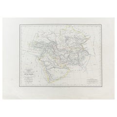
- Antique Carte de De la Perse Saudie Arabia UAE Turkey Qatar Bahrein, 1836Located in Amsterdam, Noord HollandAntique Carte de De la Perse Saudie Arabia UAE Turkey Qatar Bahrein, 1836 Very nice map of Middle East. Additional information: Material: Paper Typ...Category
Antique 18th Century European Maps
MaterialsPaper
- Antique Carte de L'Inde Myanmar, Malaysia Vietnam Map of Asia the Chinese EmpireLocated in Amsterdam, Noord HollandAntique Carte de L'Inde Myanmar, Malaysia Vietnam Map of Asia the Chinese Empire Very nice map of Asia. Additional information: Type: Map Country of Man...Category
Antique 18th Century European Maps
MaterialsPaper
- Antique Map of South America by De la Harpe '1780'Located in Langweer, NLAntique map titled 'Carte de l'Amerique Méridionale'. Original antique map of South America. Note the 'Laguna de Xarayes' is illustrated as the source of the Paraguay river. The laguna is now known as Pantanal, world's largest tropical wetland area. This map orginates from 'Abrégé de l'histoire générale des Voyages' by J.F. de la Harpe.Category
Antique Late 18th Century Maps
MaterialsPaper


Recently Viewed
View AllMore Ways To Browse
Engraved 68
Asie Antique
Antique Style Atlas
Nautical Map
Nautical Maps
Antique Ship Decor
Pacific Map
Coastal Maps
Antique Sea Chart
Mexico Antique Map
Antique Roman Map
Antique Maps Mexico
Antique Sea Charts
Amsterdam Coat Of Arms
Antique Texas Collectables
Large Map Of The Netherlands
Antique Furniture Alexandria
Victorian Fence