Items Similar to 1723 Antique Map of Asia – Carte d’Asie by Guillaume Delisle, Paris


Video Loading
Want more images or videos?
Request additional images or videos from the seller
1 of 12
1723 Antique Map of Asia – Carte d’Asie by Guillaume Delisle, Paris
$1,588.22per set
£1,182.41per set
€1,340per set
CA$2,188.32per set
A$2,436.69per set
CHF 1,288.58per set
MX$29,653.06per set
NOK 16,242.84per set
SEK 15,303.14per set
DKK 10,200.79per set
About the Item
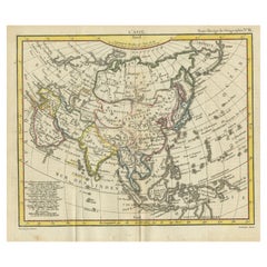
Title: Carte d'Asie – Rare Hand-Colored Map of Asia by Guillaume Delisle, Paris 1723
Description:
This rare and highly decorative antique map titled 'Carte d'Asie', engraved and hand-colored by 'Guillaume Delisle' and published in Paris in 1723, is one of the most influential 18th-century maps of Asia. Delisle, considered the father of modern cartography in France, was known for his emphasis on geographic accuracy and for incorporating the latest scientific observations into his maps. This edition was published 'Chez l’Auteur' (at the author’s address) in Paris and bears the signature hallmarks of Delisle's work, including detailed coastlines, precisely delineated political boundaries, and careful labeling of rivers, mountain ranges, and cities.
The map spans the entire continent of Asia, stretching from the eastern Mediterranean and the Arabian Peninsula across Central Asia, India, China, Japan, and all the way to New Guinea and parts of Southeast Asia, including the Philippines, Borneo, Sumatra, and Java. It is beautifully colored by hand, with major empires and regions outlined in vivid red, yellow, green, and blue tones.
One especially noteworthy feature is the depiction of Hokkaido (labeled as Yedso) merged with the northeastern landmass of Siberia—a common cartographic misconception of the period that highlights the era's evolving understanding of East Asian geography. The vast regions of Tartarie Indépendante, Empire du Grand Mogol, and Empire de la Chine are clearly labeled, as are numerous islands in the Mer des Indes and Mer du Sud.
The map includes an elegant title cartouche in the upper right corner, with dedication and publishing details, reinforcing its status as a formal, scholarly work. Delisle’s maps were widely respected and used throughout Europe and became a reference for later mapmakers.
This is a historically significant and visually striking map, ideal for collectors of antique cartography, maps of Asia, or early Enlightenment-era geographic works.
Keywords: Guillaume Delisle map, 18th-century Asia map, antique French cartography, map of Asia 1723, hand-colored map Paris, Hokkaido early map error, Tartary map, Grand Mogol Empire, antique map Southeast Asia, Mer des Indes map, Paris Chez l’Auteur.
Condition:
Good condition for its age. Original hand coloring remains vivid. The paper shows some typical age-related toning, with light edge wear and a faint centerfold as issued. Minor spotting in the margins, but the image area is clean and well-preserved. No restorations but some small tears outside the platemark and image.
Framing Tip:
This map would benefit from a wide mat in soft ivory or antique cream, paired with a classic gilt, black, or walnut wooden frame to complement the historic character. Museum-grade glass is recommended to protect the pigments and paper from UV exposure. Ideal for libraries, offices, or galleries with a focus on global history, exploration, or cartography.
- Dimensions:Height: 18.9 in (48 cm)Width: 24.61 in (62.5 cm)Depth: 0.01 in (0.2 mm)
- Sold As:Set of 2
- Materials and Techniques:Paper,Engraved
- Place of Origin:
- Period:
- Date of Manufacture:1723
- Condition:Good condition. Original hand coloring is vivid. The decorative paper shows some typical age-related toning, light edge wear (tears) and a faint centerfold as issued. Minor spotting in the margins, but the image area is clean and well-preserved.
- Seller Location:Langweer, NL
- Reference Number:Seller: BG-140861stDibs: LU3054345560922
About the Seller
5.0
Recognized Seller
These prestigious sellers are industry leaders and represent the highest echelon for item quality and design.
Platinum Seller
Premium sellers with a 4.7+ rating and 24-hour response times
Established in 2009
1stDibs seller since 2017
2,567 sales on 1stDibs
Typical response time: <1 hour
- ShippingRetrieving quote...Shipping from: Langweer, Netherlands
- Return Policy
Authenticity Guarantee
In the unlikely event there’s an issue with an item’s authenticity, contact us within 1 year for a full refund. DetailsMoney-Back Guarantee
If your item is not as described, is damaged in transit, or does not arrive, contact us within 7 days for a full refund. Details24-Hour Cancellation
You have a 24-hour grace period in which to reconsider your purchase, with no questions asked.Vetted Professional Sellers
Our world-class sellers must adhere to strict standards for service and quality, maintaining the integrity of our listings.Price-Match Guarantee
If you find that a seller listed the same item for a lower price elsewhere, we’ll match it.Trusted Global Delivery
Our best-in-class carrier network provides specialized shipping options worldwide, including custom delivery.More From This Seller
View AllAntique Map of Asia by Tirion 'c.1760'
Located in Langweer, NL
Antique map titled 'Nuova Carta dell Asia'. Decorative map of Asia. Published by I. Tirion, circa 1760.
Category
Antique Mid-18th Century Maps
Materials
Paper

$1,043 Sale Price
20% Off
Large Antique Map of Asia including All of Southeast Asia, c.1792
Located in Langweer, NL
Antique map titled 'L' Asie Divisee en ses Empires, Royaumes, et Etats'. Attractive, large map of Asia including all of Southeast Asia. The cartography is archaic for the period with...
Category
Antique 18th Century Maps
Materials
Paper

$1,422 Sale Price
20% Off
Free Shipping
Antique Map of Asia by Guthrie, 1787
Located in Langweer, NL
Antique map titled 'Asia from the best Authorities'. Old map of the Asian continent. This map originates from 'A New Geographical, Historical and Commercial Grammar; and Present State of the several Kingdoms of the World' 10th ed. by W. Guthrie.
Artists and Engravers: Published by Ch.Dilly; GGJ...
Category
Antique 18th Century Maps
Materials
Paper

$137 Sale Price
20% Off
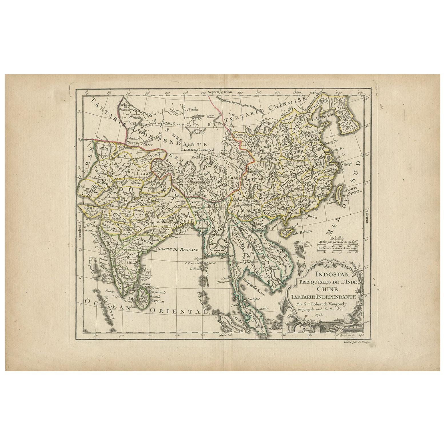
Antique Map of Asia by Dussy, 1778
Located in Langweer, NL
Antique map of Asia titled 'Indostan presqu'isles de l'Inde, Chine, Tartarie Independante'. Depicting South-East Asia including Hindustan, India an...
Category
Antique Late 18th Century French Maps
Materials
Paper
$208 Sale Price
20% Off
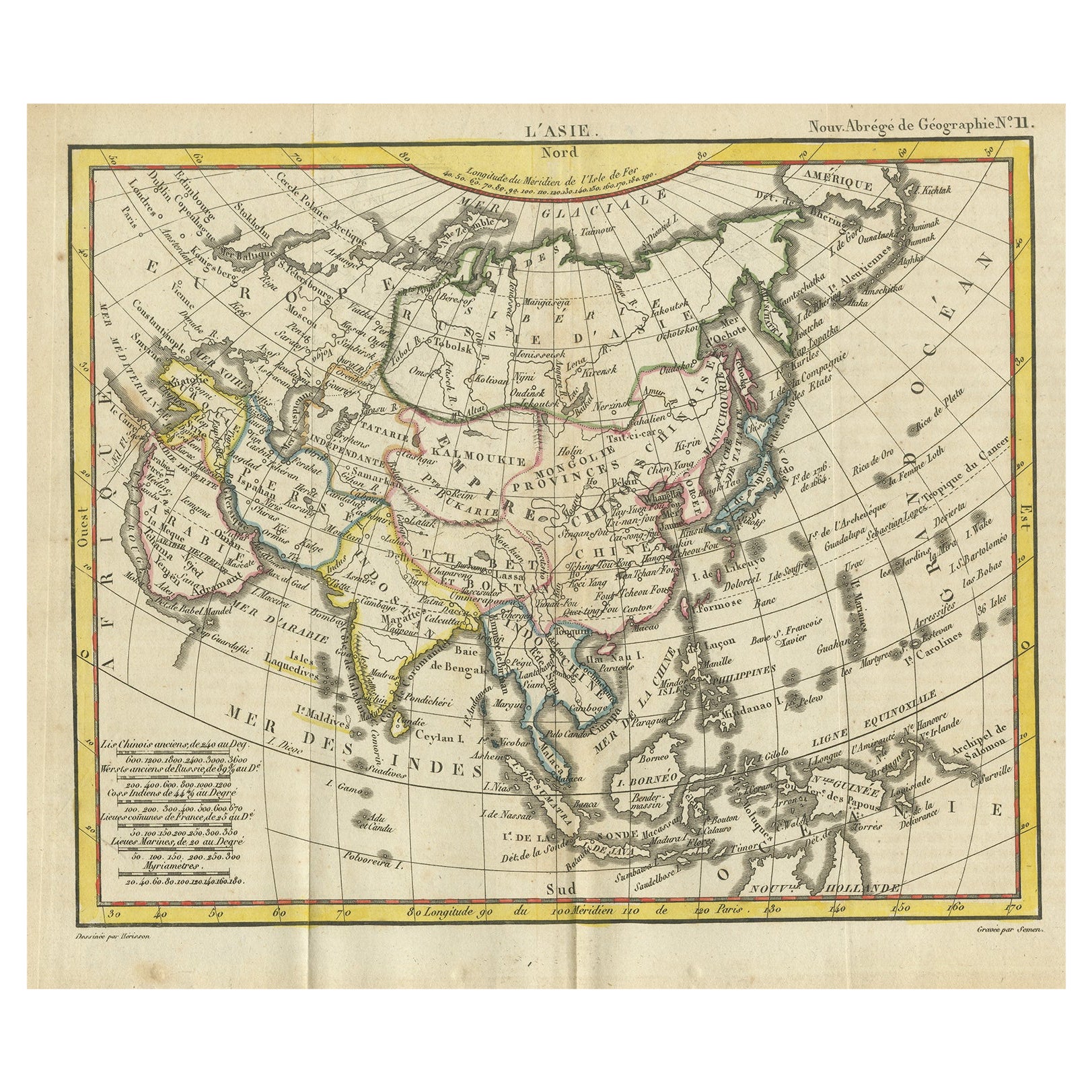
Antique Map of Asia from the Middle East to the Coast of Alaska, 1816
Located in Langweer, NL
Antique map titled ‘L’Asie‘. This is an original antique map of Asia, by Hérisson, taken from atlas ""Nouv. Abrége de Géographie"". An engraved map with coloring of Asia from the Mid...
Category
Antique 19th Century Maps
Materials
Paper
$151 Sale Price
20% Off
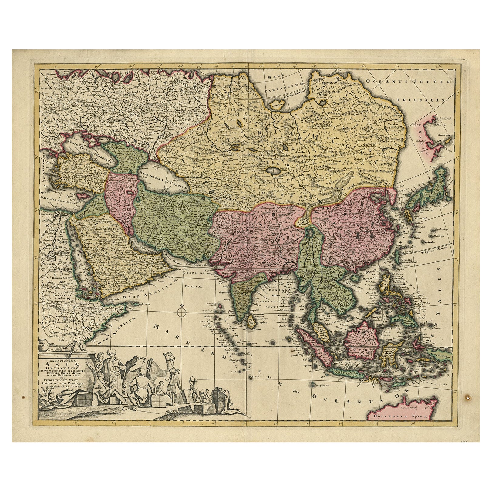
Antique Map of Asia with Northern Portion of Australia “Hollandia Nova", 1727
Located in Langweer, NL
Antique map titled 'Exactissima Asiae Delineatio in praecipuas regiones Caeterasq Partes.' Original antique map of the continent of Asia with a northern portion of Australia “Holland...
Category
Antique 18th Century Maps
Materials
Paper
$1,564 Sale Price
20% Off
You May Also Like
Antique 1803 Italian Map of Asia Including China Indoneseia India
Located in Amsterdam, Noord Holland
Antique 1803 Italian Map of Asia Including China Indoneseia India
Very nice map of Asia. 1803.
Additional information:
Type: Map
Country of Manufacturing: Europe
Period: 19th centu...
Category
Antique 19th Century European Maps
Materials
Paper

$584 Sale Price
20% Off
Antique French Map of Asia Including China Indoneseia India, 1783
Located in Amsterdam, Noord Holland
Very nice map of Asia. 1783 Dedie au Roy.
Additional information:
Country of Manufacturing: Europe
Period: 18th century Qing (1661 - 1912)
Condition: Overall Condition B (Good Used)...
Category
Antique 18th Century European Maps
Materials
Paper

$648 Sale Price
20% Off
Asia Declineatio: A 17th Century Hand-colored Map of Asia by Justus Danckerts
Located in Alamo, CA
This is a scarce 17th century beautifully hand-colored copperplate engraved map of Asia entitled “Exactissima Asiae Delineatio in Praecipuas Regiones Caerterasque Partes divisa et de...
Category
Late 17th Century Old Masters Landscape Prints
Materials
Engraving

Map of the East Indies: An Original 18th Century Hand-colored Map by E. Bowen
Located in Alamo, CA
This is an original 18th century hand-colored map entitled "An Accurate Map of the East Indies Exhibiting the Course of the European Trade both on the Continent and Islands" by Emanu...
Category
Mid-18th Century Old Masters Landscape Prints
Materials
Engraving

Super Rare Antique French Map of Chine and the Chinese Empire, 1780
Located in Amsterdam, Noord Holland
Super Rare Antique French Map of Chine and the Chinese Empire, 1780
Very nice map of Asia. 1780 Made by Bonne.
Additional information:
Type: Map
...
Category
Antique 18th Century European Maps
Materials
Paper

$584 Sale Price
32% Off
Original Antique Map of China, Arrowsmith, 1820
Located in St Annes, Lancashire
Great map of China
Drawn under the direction of Arrowsmith
Copper-plate engraving
Published by Longman, Hurst, Rees, Orme and Brown, 1820
Unfr...
Category
Antique 1820s English Maps
Materials
Paper

More Ways To Browse
Antique Ivory Collectables
Empire Library
Philippines Antique
Antique Japanese Ivory
Borneo Mat
Styles Of Antique Desks
Black And White Coffee Table
Curved Velvet Couch
Velvet Curved Sofa
Wood Round Coffee Tables
Antique Paper Flowers
Oak Brutalist
Used College Furniture
Wood Minimalist Chair
2002 Lamp
Antique Imperial Furniture
Gold Modern Coffee Table
Large Side Tables