Items Similar to 1792 Hand-Colored Plan of St. Petersburg and Moscow in Russia
Want more images or videos?
Request additional images or videos from the seller
1 of 6
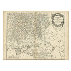
1792 Hand-Colored Plan of St. Petersburg and Moscow in Russia
$460.77
£345.37
€390
CA$633.01
A$706.70
CHF 370.30
MX$8,650.72
NOK 4,702.83
SEK 4,434.17
DKK 2,968.82
About the Item
Title: 1792 Hand-Colored Plan of St. Petersburg and Moscow
Description: This rare 1792 map features detailed plans of two iconic Russian cities, St. Petersburg and Moscow. The upper map highlights St. Petersburg’s elegant baroque layout with its canals and fortifications, while the lower map showcases Moscow’s historic core, including the Kremlin and surrounding districts. Each city plan is hand-colored to delineate different zones, streets, and notable landmarks.
The maps provide a fascinating snapshot of urban development in imperial Russia, reflecting the architectural and cultural contrasts between the westernized capital, St. Petersburg, and the older, fortified city of Moscow.
Condition report: The map is in good condition for its age. The paper is strong and stable with vibrant hand-coloring. Minor toning and very light foxing are present in the margins but do not detract from the overall quality.
Framing tip: Use archival materials with UV-protective glass to preserve the hand-coloring and paper integrity. A neutral mat with a gilded or dark wooden frame will complement the map’s historic aesthetic, making it a stunning addition to any collection or display.
- Dimensions:Height: 10.63 in (27 cm)Width: 7.49 in (19 cm)Depth: 0.01 in (0.2 mm)
- Materials and Techniques:Paper,Engraved
- Period:1790-1799
- Date of Manufacture:1792
- Condition:Condition report: The map is in good condition for its age. The paper is strong and stable with vibrant hand-coloring. Minor toning and very light foxing are present in the margins but do not detract from the overall quality.
- Seller Location:Langweer, NL
- Reference Number:Seller: BG-13202-141stDibs: LU3054343379372
About the Seller
5.0
Recognized Seller
These prestigious sellers are industry leaders and represent the highest echelon for item quality and design.
Platinum Seller
Premium sellers with a 4.7+ rating and 24-hour response times
Established in 2009
1stDibs seller since 2017
2,513 sales on 1stDibs
Typical response time: <1 hour
- ShippingRetrieving quote...Shipping from: Langweer, Netherlands
- Return Policy
Authenticity Guarantee
In the unlikely event there’s an issue with an item’s authenticity, contact us within 1 year for a full refund. DetailsMoney-Back Guarantee
If your item is not as described, is damaged in transit, or does not arrive, contact us within 7 days for a full refund. Details24-Hour Cancellation
You have a 24-hour grace period in which to reconsider your purchase, with no questions asked.Vetted Professional Sellers
Our world-class sellers must adhere to strict standards for service and quality, maintaining the integrity of our listings.Price-Match Guarantee
If you find that a seller listed the same item for a lower price elsewhere, we’ll match it.Trusted Global Delivery
Our best-in-class carrier network provides specialized shipping options worldwide, including custom delivery.More From This Seller
View AllAntique Hand-Colored Map of Western Russia and Ukraine, c.1680
Located in Langweer, NL
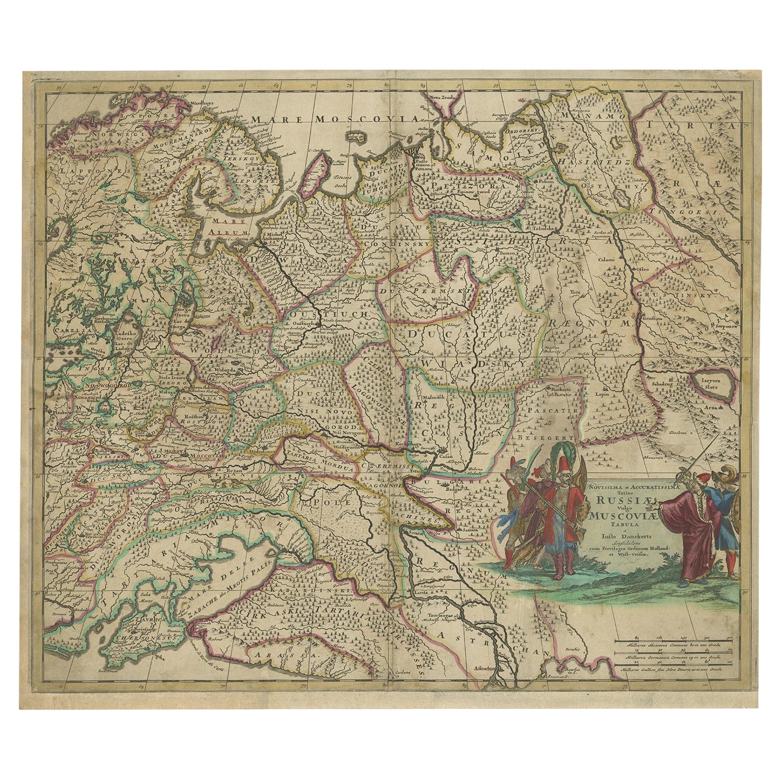
Description: Antique map titled 'Novissima et Accuratissima Totius Russiae vulgo Muscoviae Tabula'.
Antique map of Western Russia and Ukraine, published by Justus Danckerts. The ma...
Category
Antique 1680s Maps
Materials
Paper
$708 Sale Price
20% Off
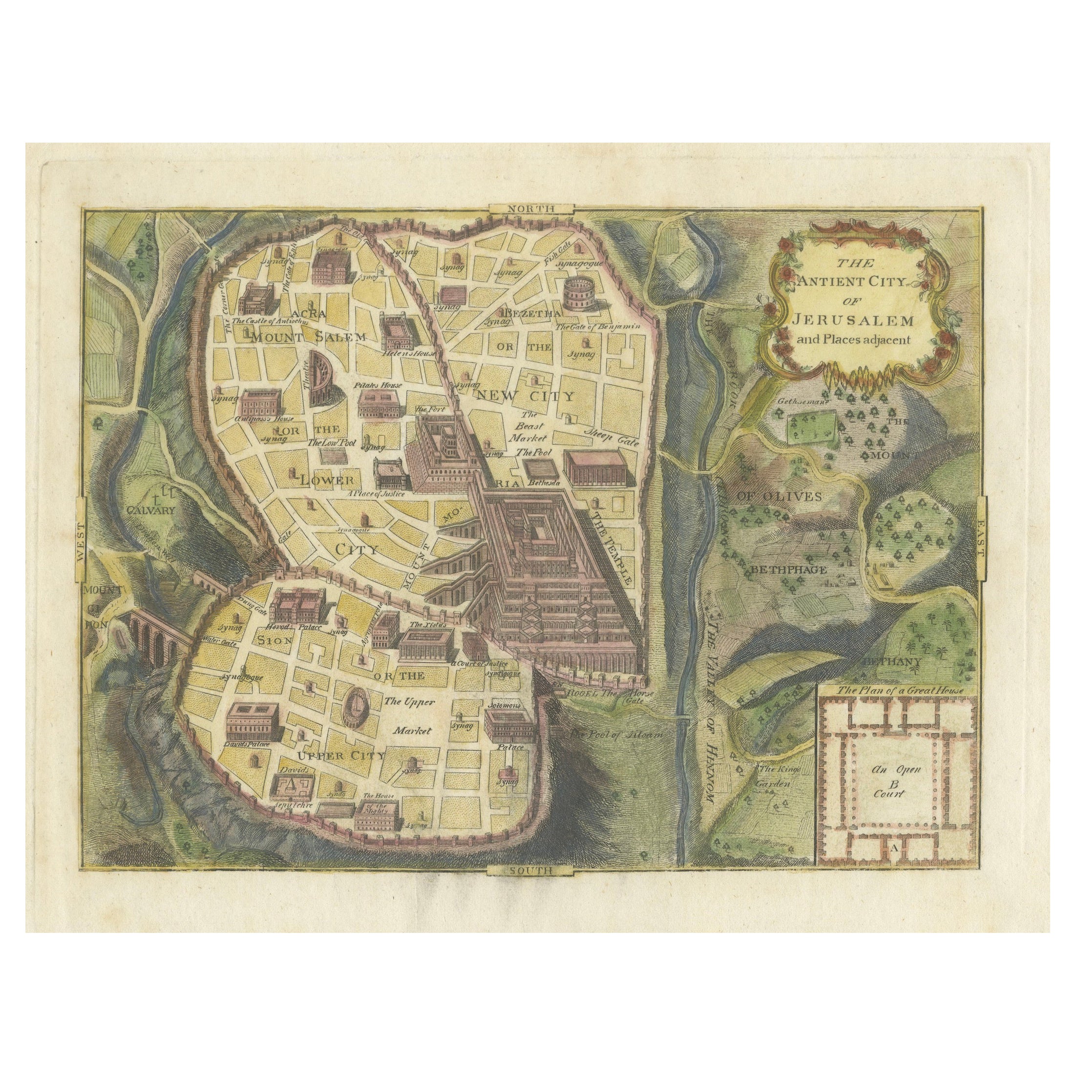
The Antient City of Jerusalem and Places Adjacent, Hand-Colored Map, 1699
Located in Langweer, NL
Title: "1699 Hand-Colored Bird's-Eye Plan of Jerusalem with Ancient and Biblical Landmarks"
This beautifully hand-colored, imaginary bird's-eye plan of Jerusalem, published in 1699,...
Category
Antique 1690s Maps
Materials
Paper
$245 Sale Price
20% Off
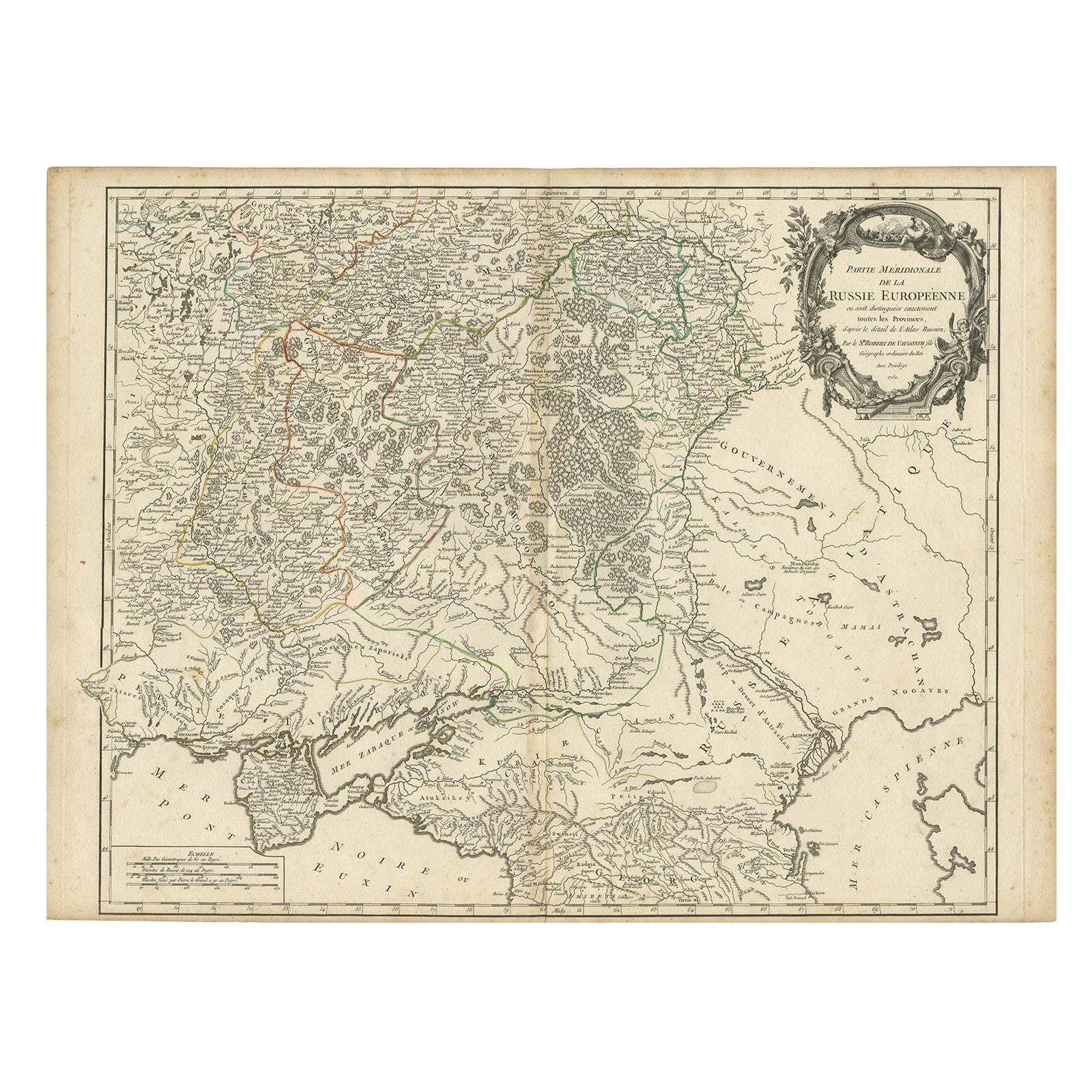
Detailed Antique Map of the Southern Part of European Russia and Ukraine, 1752
Located in Langweer, NL
Antique map titled 'Partie meridionale de la Russie Européenne'.
Detailed map of the southern part of European Russia by Robert de Vaugondy. It covers from Moscow south to Georgia and from Poland east to the Volga River, including Crimea and Ukraine.
Artists and engravers: Gilles Robert de Vaugondy (1688-1766) was the head of a leading family of geographers in eighteenth century France. Gilles got his start when he jointly inherited the shop of Pierre-Moullart Sanson, grandson of the famous geographer Nicholas Sanson. The inheritance included the business, its stock of plates, and a roller press...
Category
Antique 1750s Maps
Materials
Paper
$718 Sale Price
20% Off
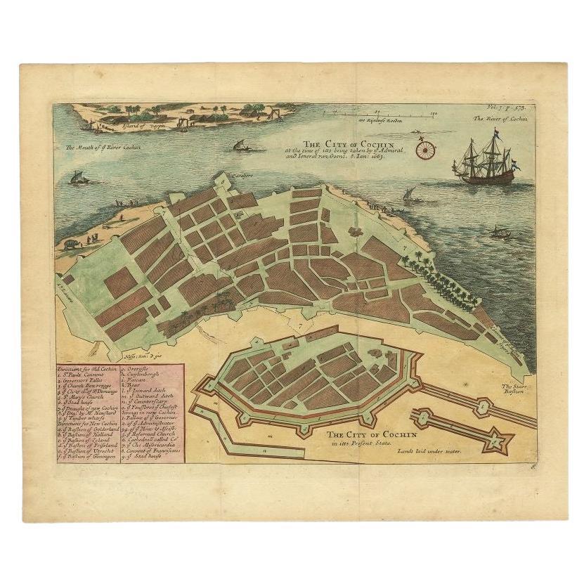
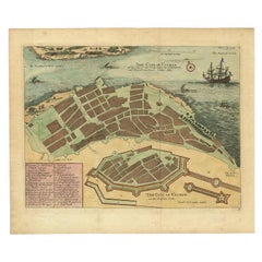
Very Attractive Handcolored Antique Plan of Cochin in India, 1744
By Philip Baldaeus
Located in Langweer, NL
Antique map titled 'The City of Cochin (..).' Plan of Cochin, Malabar Coast, India, during the attack by Admiral van Goens in 1663. This map was published in 'The True and Exact Desc...
Category
Antique 18th Century Maps
Materials
Paper
$793 Sale Price
20% Off
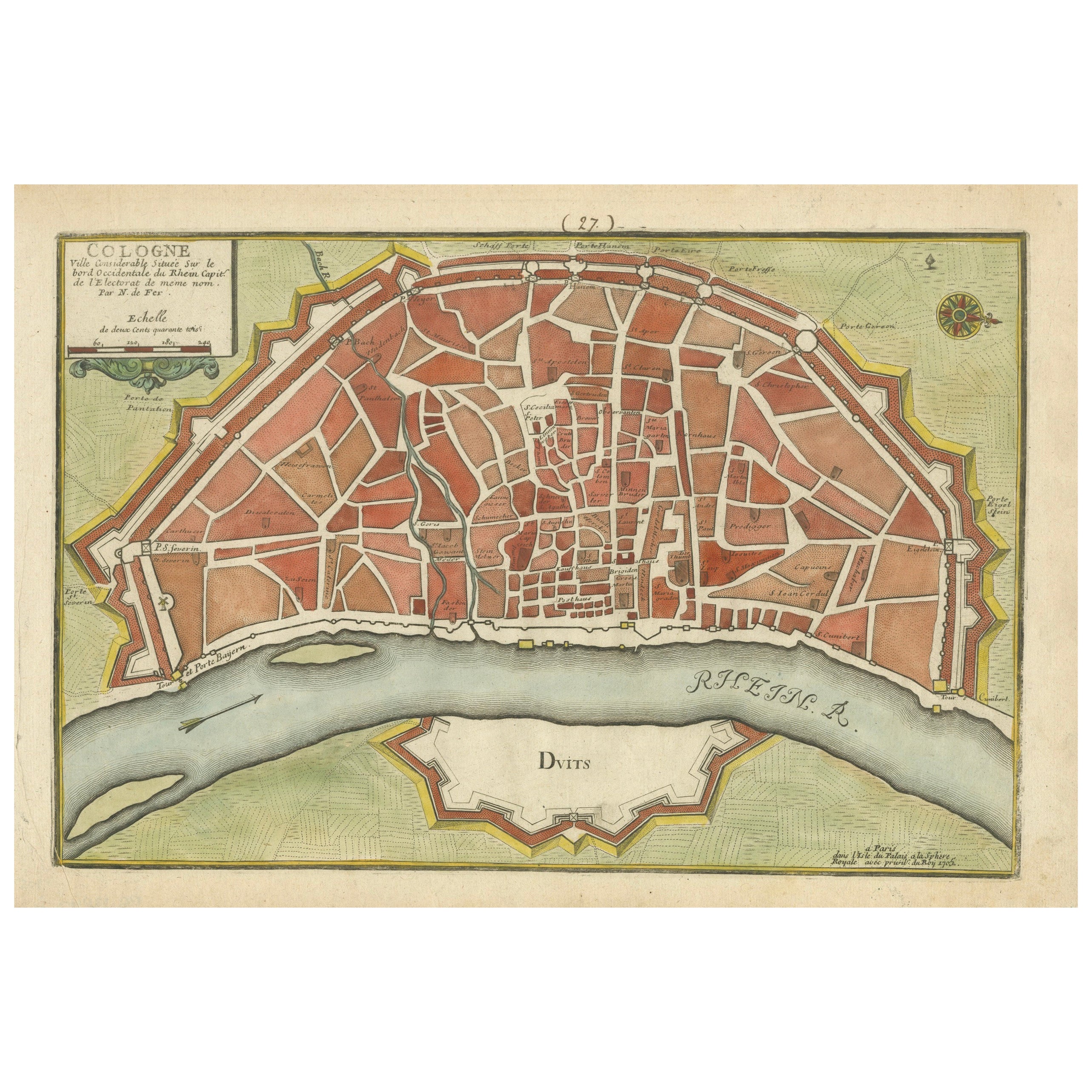
Hand-Colored City Plan of Cologne by Nicolas de Fer, 1705
Located in Langweer, NL
Title: Hand-Colored City Plan of Cologne by Nicolas de Fer, 1705
This hand-colored map, titled "Cologne Ville Considerable Situee sur le Bord Occidentale du Rhein Capit. de l'Electo...
Category
Antique Early 1700s Maps
Materials
Paper
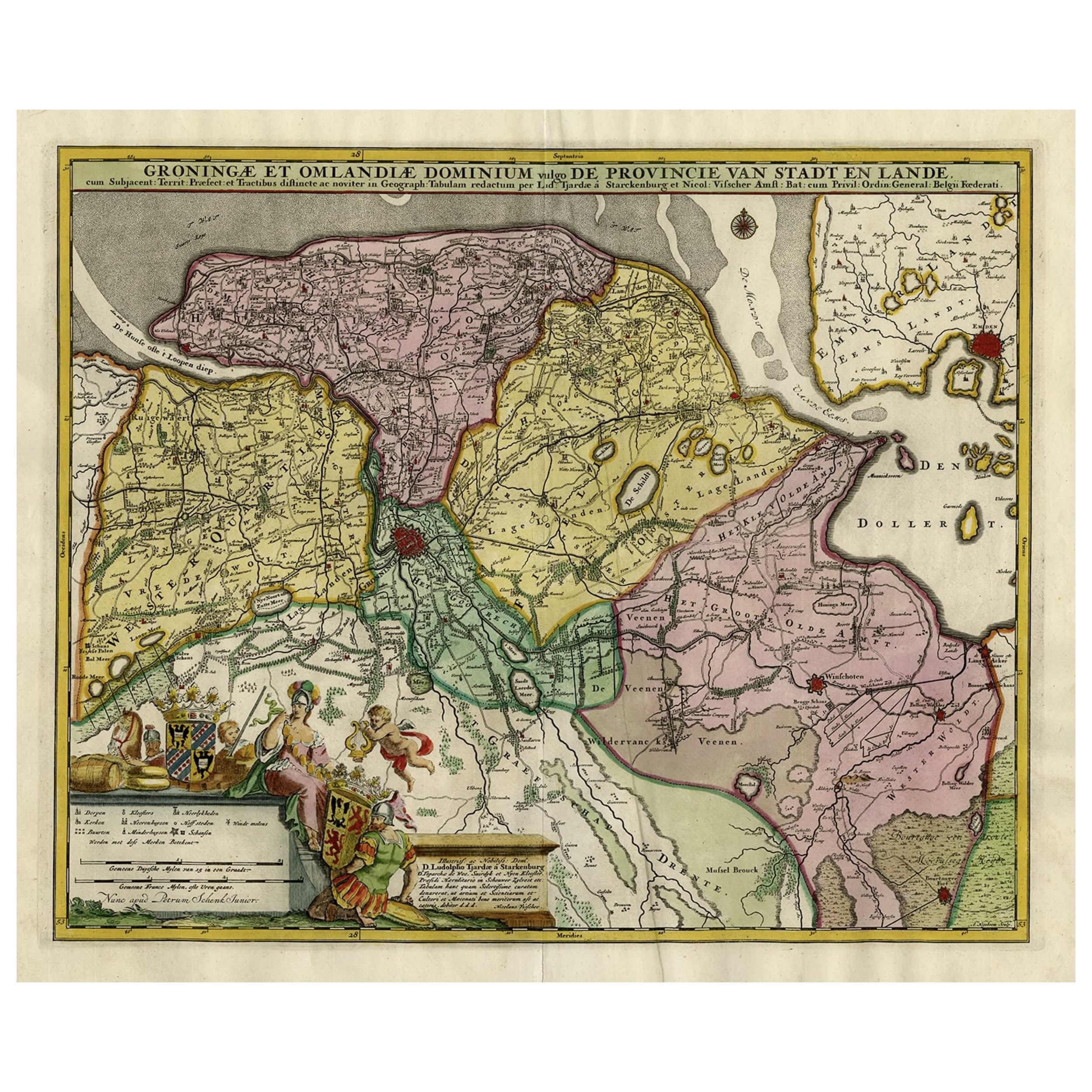
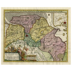
Decorative Hand-Colored Antique Map of Groningen in the Netherlands, ca.1730
Located in Langweer, NL
Antique print, titled: 'Groningae et Omlandiae Dominium vulgo de Provincie van Stadt en Lande (…) ' - This map shows Groningen, the Netherlands. Lower left scale sticks in the decora...
Category
Antique 1730s Maps
Materials
Paper
$1,181 Sale Price
20% Off
You May Also Like
18th Century Hand-Colored Homann Map of Germany, Including Frankfurt and Berlin
By Johann Baptist Homann
Located in Alamo, CA
An 18th century hand-colored map entitled "Tabula Marchionatus Brandenburgici et Ducatus Pomeraniae quae sunt Pars Septentrionalis Circuli Saxoniae Superioris" by Johann Baptist Homa...
Category
Antique Early 18th Century German Maps
Materials
Paper

Vienna, Austria: A Large 17th Century Hand-Colored Map by Sanson and Jaillot
By Nicolas Sanson
Located in Alamo, CA
This large 17th century hand-colored map of Vienna, Austria and the surrounding countryside and villages entitled "Plan de la Ville de Vienne en Austrich...
Category
Antique 1690s French Maps
Materials
Paper

Prussia, Poland, N. Germany, Etc: A Hand-colored 17th Century Map by Janssonius
By Johannes Janssonius
Located in Alamo, CA
This is an attractive hand-colored copperplate engraved 17th century map of Prussia entitled "Prussia Accurate Descripta a Gasparo Henneberg Erlichensi", published in Amsterdam by Joannes Janssonius in 1664. This very detailed map from the golden age of Dutch cartography includes present-day Poland, Latvia, Lithuania, Estonia and portions of Germany. This highly detailed map is embellished by three ornate pink, red, mint green and gold...
Category
Antique Mid-17th Century Dutch Maps
Materials
Paper

Hand Colored 17th Century Visscher Map "Hollandiae" Southern Holland
By Nicolaes Visscher II
Located in Alamo, CA
A hand colored 17th century map of the southern portions of Holland by Nicolaus (Nicolas) Visscher II entitled "Hollandiae pars Meridionalis, vulgo Zuyd-Holland", published in Amsterdam in 1678. The map shows the region between Breda, Heusden, Gornichem, Gouda, Dordrecht, and Willemstad. It includes a decorative cartouche in the lower left corner.
The map is presented in an attractive maple colored wood frame with gold trim and a fabric mat.
The Visscher family were one of the great cartographic families of the 17th century. Begun by Claes Jansz Visscher...
Category
Antique Early 18th Century Dutch Maps
Materials
Paper

17th Century Hand Colored Map of the Liege Region in Belgium by Visscher
By Nicolaes Visscher II
Located in Alamo, CA
An original 17th century map entitled "Leodiensis Episcopatus in omnes Subjacentes Provincias distincté divisusVisscher, Leodiensis Episcopatus" by Nicolaes Visscher II, published in Amsterdam in 1688. The map is centered on Liege, Belgium, includes the area between Antwerp, Turnhout, Roermond, Cologne, Trier and Dinant.
This attractive map is presented in a cream-colored mat measuring 30" wide x 27.5" high. There is a central fold, as issued. There is minimal spotting in the upper margin and a tiny spot in the right lower margin, which are under the mat. The map is otherwise in excellent condition.
The Visscher family were one of the great cartographic families of the 17th century. Begun by Claes Jansz Visscher...
Category
Antique Late 17th Century Dutch Maps
Materials
Paper

Scandinavia & Portions of Eastern Europe: 18th Century Hand-Colored Homann Map
By Johann Baptist Homann
Located in Alamo, CA
An early 18th century hand-colored copper-plate map entitled "Regni Sueciae in omnes suas Subjacentes Provincias accurate divisi Tabula Generalis" by Johann Baptist Homann (1663-1724...
Category
Antique Early 18th Century German Maps
Materials
Paper

More Ways To Browse
Antique St Petersburg Russia
Antique Architectural Plans
Imperial Russian Glass
Russian Icon Frame
Carlo Scarpa 1934 Chairs
Christofle Marly
1900 Antique Chairs
Glass Table Italian Round
Alvar Aalto Poster
Geometric Metal Table
Post Modern High Chairs
Vintage Vine Rug
Cancel An Order
Antique Framing Square
Silver Metal Chair
Swedish Kilim
Vintage Scandanavian Chairs
Vintage Tropical Furniture