Items Similar to 1797 Tardieu Map of Southeast Asia: The Malay Archipelago and Beyond


Want more images or videos?
Request additional images or videos from the seller
1 of 8
1797 Tardieu Map of Southeast Asia: The Malay Archipelago and Beyond
$1,102.29
$1,377.8720% Off
£820.43
£1,025.5420% Off
€920
€1,15020% Off
CA$1,509.86
CA$1,887.3320% Off
A$1,679.30
A$2,099.1220% Off
CHF 876.88
CHF 1,096.1020% Off
MX$20,435.28
MX$25,544.1020% Off
NOK 11,199.07
NOK 13,998.8320% Off
SEK 10,502.75
SEK 13,128.4420% Off
DKK 7,003.64
DKK 8,754.5520% Off
Shipping
Retrieving quote...The 1stDibs Promise:
Authenticity Guarantee,
Money-Back Guarantee,
24-Hour Cancellation
About the Item
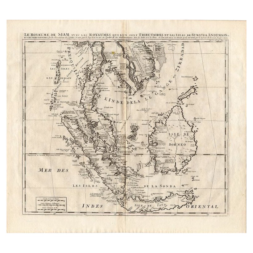
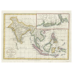
An original historical map titled 'Presqu' Île Au Dela Du Gange et Archipel De L'Inde', created by Pierre Francois Tardieu and published in the "Atlas Universel" by Pierre Grégoire Chanlaire & Edmonde Mentelle in Paris, 1797. It depicts the region from Bangladesh to Papua New Guinea, with a central focus on Borneo and the Philippines. Printed on strong hand-pressed paper.
Step back into the age of exploration with this meticulously hand-colored 1797 engraving by the esteemed cartographer Pierre Francois Tardieu. This rare collector's piece, from the Atlas Universel, offers a detailed glimpse into the maritime heart of Southeast Asia, highlighting the 'Presqu' Île Au Dela Du Gange et Archipel De L'Inde'. It is a treasure trove for map enthusiasts and historians alike, featuring the Malay Archipelago with remarkable precision. Borneo and the Philippines are centrally placed, flanked by the intricate web of islands stretching from Bangladesh to the exotic east of Papua New Guinea. Singapore is mentioned already. This decorative and educational map is a must-have for connoisseurs of geographic art and a unique testament to the cartographic achievements of the 18th century."
Such a description would cater to collectors interested in maritime history, cartographic art, and regional maps of Asia, enhancing the allure and perceived value of the map.
Keywords:
- Antique map
- Hand-colored engraving
- Pierre Francois Tardieu
- 18th-century cartography
- Atlas Universel
- Southeast Asia historical map
- Maritime Southeast Asia
- Collectible map
- Decorative map
- Educational piece
- Geographic art
- Borneo and Philippines
- Exploration era
- Nautical chart
- Dimensions:Height: 25.2 in (64 cm)Width: 19.1 in (48.5 cm)Depth: 0 in (0.02 mm)
- Materials and Techniques:Paper,Engraved
- Period:1790-1799
- Date of Manufacture:1797
- Condition:Condition: Good, given age. General age-related soiling but mainly outside the image in the margins. Beautiful hand-coloured, with some creasing along the centrefold. Latin text on the reverse. Restored tear in outer lower margin; otherwise fine.
- Seller Location:Langweer, NL
- Reference Number:Seller: BG-13684-11stDibs: LU3054338152982
About the Seller
5.0
Recognized Seller
These prestigious sellers are industry leaders and represent the highest echelon for item quality and design.
Platinum Seller
Premium sellers with a 4.7+ rating and 24-hour response times
Established in 2009
1stDibs seller since 2017
2,508 sales on 1stDibs
Typical response time: <1 hour
- ShippingRetrieving quote...Shipping from: Langweer, Netherlands
- Return Policy
Authenticity Guarantee
In the unlikely event there’s an issue with an item’s authenticity, contact us within 1 year for a full refund. DetailsMoney-Back Guarantee
If your item is not as described, is damaged in transit, or does not arrive, contact us within 7 days for a full refund. Details24-Hour Cancellation
You have a 24-hour grace period in which to reconsider your purchase, with no questions asked.Vetted Professional Sellers
Our world-class sellers must adhere to strict standards for service and quality, maintaining the integrity of our listings.Price-Match Guarantee
If you find that a seller listed the same item for a lower price elsewhere, we’ll match it.Trusted Global Delivery
Our best-in-class carrier network provides specialized shipping options worldwide, including custom delivery.More From This Seller
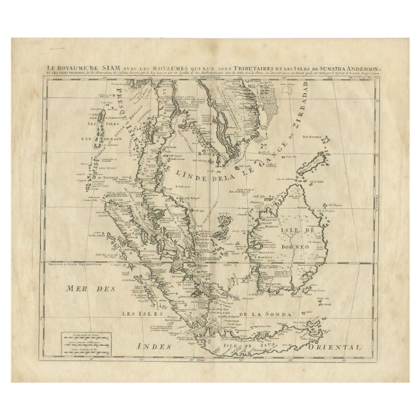
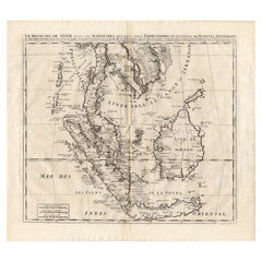
View AllAntique Map of Southeast Asia by Chatelain, c.1732
Located in Langweer, NL
"Antique map titled 'La Royaume de Siam avec les Royaumes qui luy sont Tributaires et les Isles de Sumatra Andemaon'. It shows: Southeast Asia; Borneo, Java, Siam (Thailand), Malacca...
Category
Antique 18th Century Maps
Materials
Paper

$742 Sale Price
20% Off
Original Antique Map of the Philippines, Malaysia, Indonesia, Singapore, c.1690
Located in Langweer, NL
Antique map titled 'Isole dell' Indie, diuise in Filippine, Molucche e della Sonda'.
Old map of the Philippines, Malaysia, Indonesia, Singapore, Northern Australia and contiguous i...
Category
Antique 1690s Maps
Materials
Paper

$2,156 Sale Price
20% Off
Free Shipping
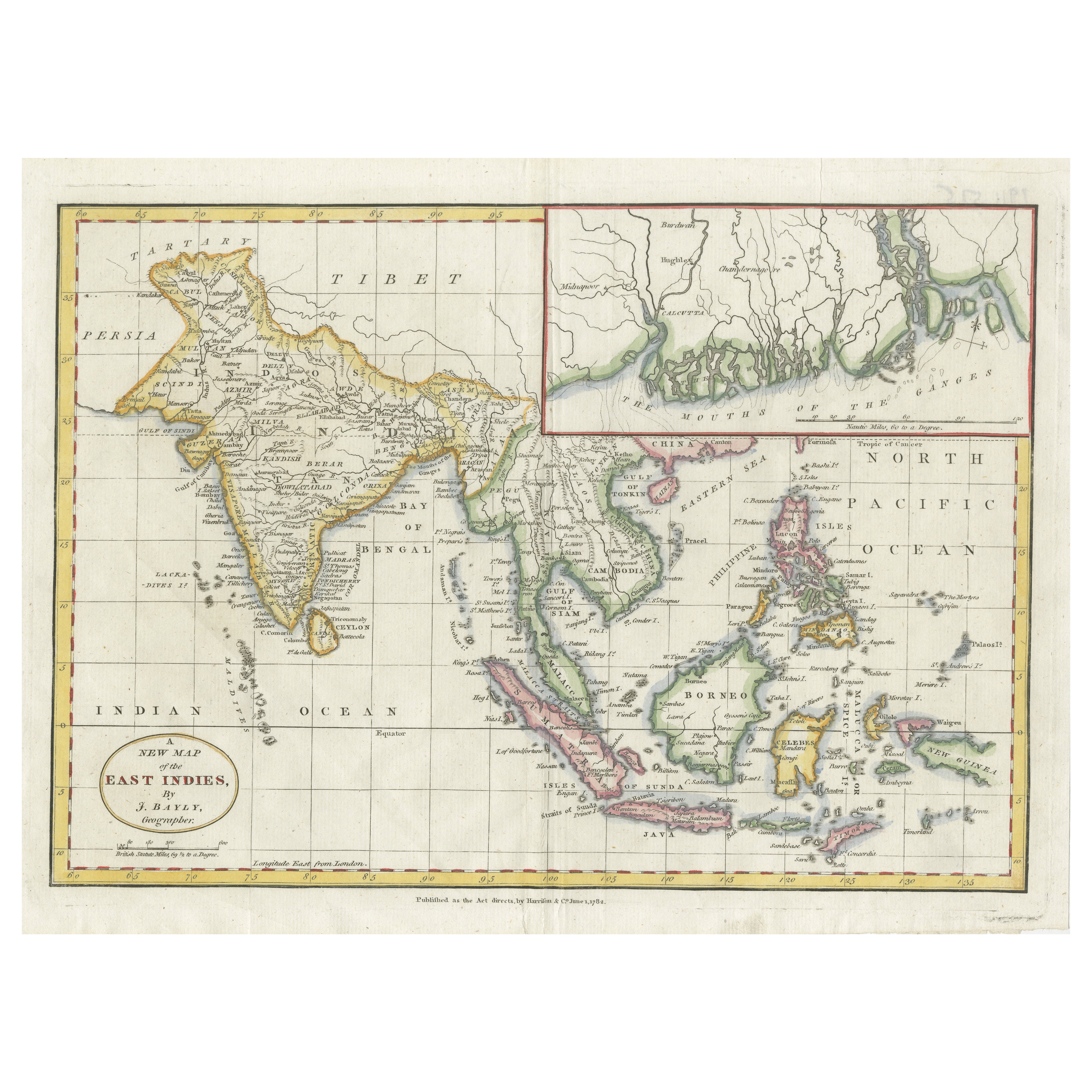
1782 Map of the East Indies – India, Siam, Philippines, Java, Borneo, Ganges
Located in Langweer, NL
1782 Bayly Map of the East Indies – India, Siam, Philippines, Java, Borneo, Ganges
This finely engraved and vibrantly hand-colored map titled 'A New Map of the East Indies' was dr...
Category
Antique 1780s Maps
Materials
Paper
$316 Sale Price
20% Off
Antique Map of Southeast Asia by Chatelain, c.1732
Located in Langweer, NL
"Antique map titled 'La Royaume de Siam avec les Royaumes qui luy sont Tributaires et les Isles de Sumatra Andemaon'. It shows: Southeast Asia; Borneo, Java, Siam (Thailand), Malacca...
Category
Antique 18th Century Maps
Materials
Paper
$772 Sale Price
25% Off
Antique Map of Southeast Asia from Persia to the Timor Island, 1712
Located in Langweer, NL
Antique map titled 'A New Map of the East Indies'.
Old map covering all of Southeast Asia from Persia to the Timor Island, inclusive of the modern day nations of India, Ceylon, T...
Category
Antique 1710s Maps
Materials
Paper

$757 Sale Price
20% Off
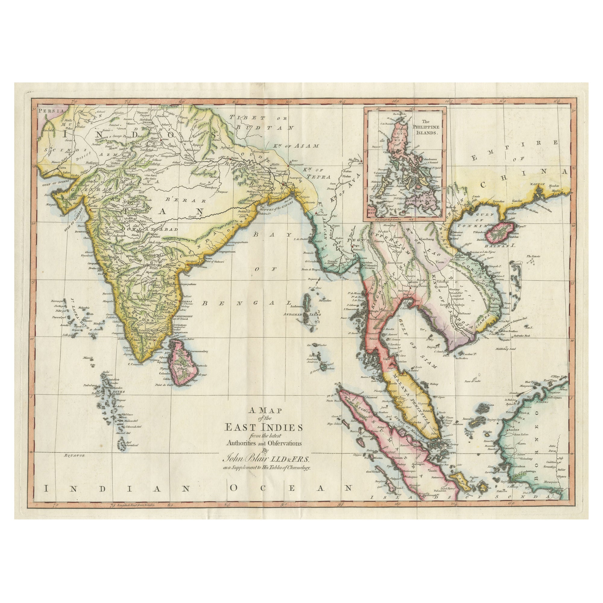
Large Antique Map of the East Indies, with Inset of the Philippines
Located in Langweer, NL
Antique map titled 'A Map of the East Indies (..)'. Large antique map of Southeast Asia, India, and part of China, extending to Tibet, the Maladives, Sumatra, part of Borneo, Hainan,...
Category
Antique Late 18th Century Maps
Materials
Paper

$469 Sale Price
20% Off
You May Also Like
Antique 1803 Italian Map of Asia Including China Indoneseia India
Located in Amsterdam, Noord Holland
Antique 1803 Italian Map of Asia Including China Indoneseia India
Very nice map of Asia. 1803.
Additional information:
Type: Map
Country of Manufacturing: Europe
Period: 19th centu...
Category
Antique 19th Century European Maps
Materials
Paper

$584 Sale Price
20% Off
Original Antique Map of South East Asia by Thomas Clerk, 1817
Located in St Annes, Lancashire
Great map of South East Asia
Copper-plate engraving
Drawn and engraved by Thomas Clerk, Edinburgh.
Published by Mackenzie And Dent, 1817
Unframed.
Category
Antique 1810s English Maps
Materials
Paper

Map of the East Indies: An Original 18th Century Hand-colored Map by E. Bowen
Located in Alamo, CA
This is an original 18th century hand-colored map entitled "An Accurate Map of the East Indies Exhibiting the Course of the European Trade both on the Continent and Islands" by Emanu...
Category
Mid-18th Century Old Masters Landscape Prints
Materials
Engraving

Antique French Map of Asia Including China Indoneseia India, 1783
Located in Amsterdam, Noord Holland
Very nice map of Asia. 1783 Dedie au Roy.
Additional information:
Country of Manufacturing: Europe
Period: 18th century Qing (1661 - 1912)
Condition: Overall Condition B (Good Used)...
Category
Antique 18th Century European Maps
Materials
Paper

$648 Sale Price
20% Off
Large Original Vintage Map of S.E Asia, with a Vignette of Singapore
Located in St Annes, Lancashire
Great map of South East Asia
Original color. Good condition
Published by Alexander Gross
Unframed.
Category
Vintage 1920s English Maps
Materials
Paper

Tabula Indiae Orientalis - Etching by Frederick de Wit - 1680ca
By Frederick de Wit
Located in Roma, IT
This double-page etching with contemporary coloring, entitled Tabula Indiae orientalis, was realized by the cartographer Frederick de Wit for the famous Atlas published in Amsterdam ...
Category
1680s Modern Figurative Prints
Materials
Etching

More Ways To Browse
Philippines Antique
Singapore Antique
L Gregoire
Early American Chairs
Hans Muller
Vintage Wood Table With Glass Top
19th Century Square Table
Antonio Bonet
Galle Chairs
Large Chinese Rug
1940s Vintage French Art Deco
20th Century Spanish Table
Antonio Bellini
Retro Fiberglass Furniture
Shipping Crate
Antique Oushak Carpets
Blue Coffee Tables
German Bauhaus Posters