Items Similar to 17th Century Cartographic Marvel: A Detailed Engraving of Guangzhou (Kanton)


Want more images or videos?
Request additional images or videos from the seller
1 of 7
17th Century Cartographic Marvel: A Detailed Engraving of Guangzhou (Kanton)
$1,054.01
$1,317.5120% Off
£781.08
£976.3520% Off
€880
€1,10020% Off
CA$1,438.93
CA$1,798.6620% Off
A$1,600.75
A$2,000.9320% Off
CHF 839.13
CHF 1,048.9120% Off
MX$19,560.72
MX$24,450.9020% Off
NOK 10,685.28
NOK 13,356.6120% Off
SEK 10,058.72
SEK 12,573.4020% Off
DKK 6,700.24
DKK 8,375.3020% Off
Shipping
Retrieving quote...The 1stDibs Promise:
Authenticity Guarantee,
Money-Back Guarantee,
24-Hour Cancellation
About the Item
This engraving of Guangzhou ("Kanton") is from a French edition of Olfert Dapper's work. The French edition titled "Description de l’Empire de la Chine" was published in 1674. It is an unusual mix between a view and a city plan.
The original Dutch edition, titled "Gedenkwaerdig Bedryf der Nederlandsche Oost-Indische Maetschappye," was published in 1670. The French edition, which contains similar engravings and maps, was published four years later to make Dapper's comprehensive descriptions of China accessible to a broader European audience.
Nieuhof's works also contain illustrations and maps of Chinese cities, as he was an explorer and draughtsman who accompanied Dutch missions to China. However, the specific engraving style and presentation of this map align more closely with Dapper's works.
This map of Guangzhou ("Kanton") from 1665 is interesting for several reasons:
1. **Historical Context**: It represents a period when European interest in Asia, particularly China, was growing rapidly. The map reflects the early interactions between Europe and China, driven by trade and exploration.
2. **Detail and Accuracy**: For its time, this map is remarkably detailed, showing the layout of Guangzhou with a grid pattern that highlights the organization of the city. It includes significant buildings, streets, and the surrounding landscape, providing a valuable snapshot of the city's structure in the 17th century.
3. **Cartographic Style**: The engraving style, typical of the 17th century, combines artistry with cartography. The inclusion of decorative elements like cherubs, ships, and a scrollwork title enhances its visual appeal and historical charm.
4. **Cultural Exchange**: This map is a product of the exchange of knowledge between Europe and China. It reflects how Europeans sought to understand and document foreign lands, contributing to the global spread of geographical knowledge.
5. **Publication History**: The map's inclusion in Olfert Dapper's work, which was translated into several languages and widely distributed, highlights its significance in the dissemination of knowledge about China in Europe. The French edition in which this map appears shows the importance of this information beyond the Dutch-speaking world.
6. **Urban Planning and Architecture**: For researchers and historians, the map provides insights into the urban planning and architecture of Guangzhou during the Ming and early Qing dynasties, showing how cities in China were organized and how they compared to European cities of the same period.
7. **Trade and Commerce**: Guangzhou was a major port city and a key hub in maritime trade, particularly in the silk, tea, and porcelain trades. The map illustrates the city's strategic importance and its role in global commerce.
Overall, this map is a valuable historical document that offers insights into 17th-century cartography, European perceptions of China, and the historical significance of Guangzhou as a major urban center.
- Dimensions:Height: 12.01 in (30.5 cm)Width: 15.52 in (39.4 cm)Depth: 0.01 in (0.2 mm)
- Materials and Techniques:Paper,Engraved
- Period:1670-1679
- Date of Manufacture:1674
- Condition:Very good, almost excellent. Acid free tape, hardly visible, for extra support. Rare in this condition. Study the images carefully.
- Seller Location:Langweer, NL
- Reference Number:Seller: BG-137421stDibs: LU3054340347002
About the Seller
5.0
Recognized Seller
These prestigious sellers are industry leaders and represent the highest echelon for item quality and design.
Platinum Seller
Premium sellers with a 4.7+ rating and 24-hour response times
Established in 2009
1stDibs seller since 2017
2,494 sales on 1stDibs
Typical response time: 1 hour
- ShippingRetrieving quote...Shipping from: Langweer, Netherlands
- Return Policy
Authenticity Guarantee
In the unlikely event there’s an issue with an item’s authenticity, contact us within 1 year for a full refund. DetailsMoney-Back Guarantee
If your item is not as described, is damaged in transit, or does not arrive, contact us within 7 days for a full refund. Details24-Hour Cancellation
You have a 24-hour grace period in which to reconsider your purchase, with no questions asked.Vetted Professional Sellers
Our world-class sellers must adhere to strict standards for service and quality, maintaining the integrity of our listings.Price-Match Guarantee
If you find that a seller listed the same item for a lower price elsewhere, we’ll match it.Trusted Global Delivery
Our best-in-class carrier network provides specialized shipping options worldwide, including custom delivery.More From This Seller
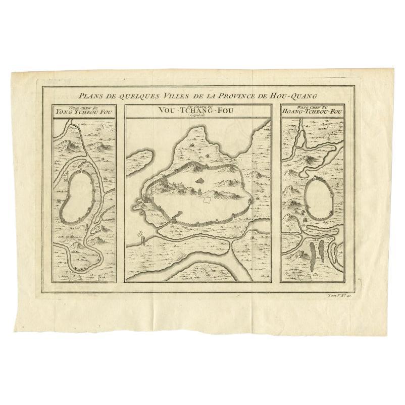
View AllAntique Map of Cities in the Region of Hubei in China, 1758
Located in Langweer, NL
Antique map titled 'Plans de Quelques villes de la province de Hou-Quang.' Three plans of cities in a region named Hou-Quang (currently Hubei). While these maps by Van Schley after B...
Category
Antique 18th Century Maps
Materials
Paper

$306 Sale Price
20% Off
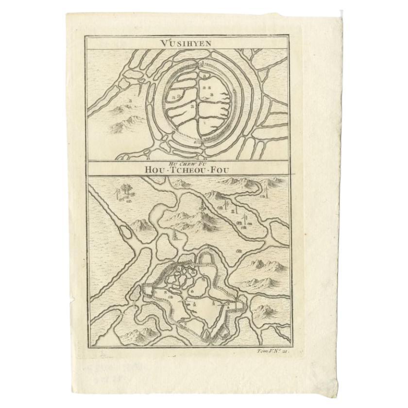
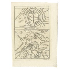
Antique Map of Wuxi and Huzhou in China, 1746
Located in Langweer, NL
Antique map titled 'Vusihyen. Hu Chew Fu'. Plans of Wuxi and Huzhou, China. Originates from Prévost's 'Histoire générale des voyages'.
Artists and Engravers: Antoine François Prévo...
Category
Antique 18th Century Maps
Materials
Paper
$143 Sale Price
20% Off
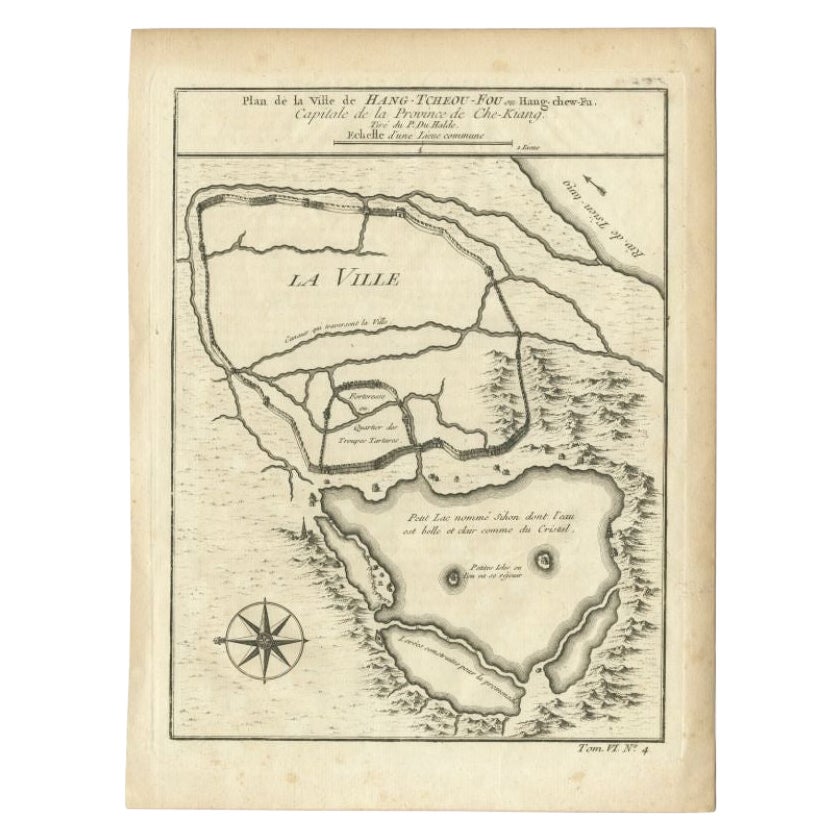
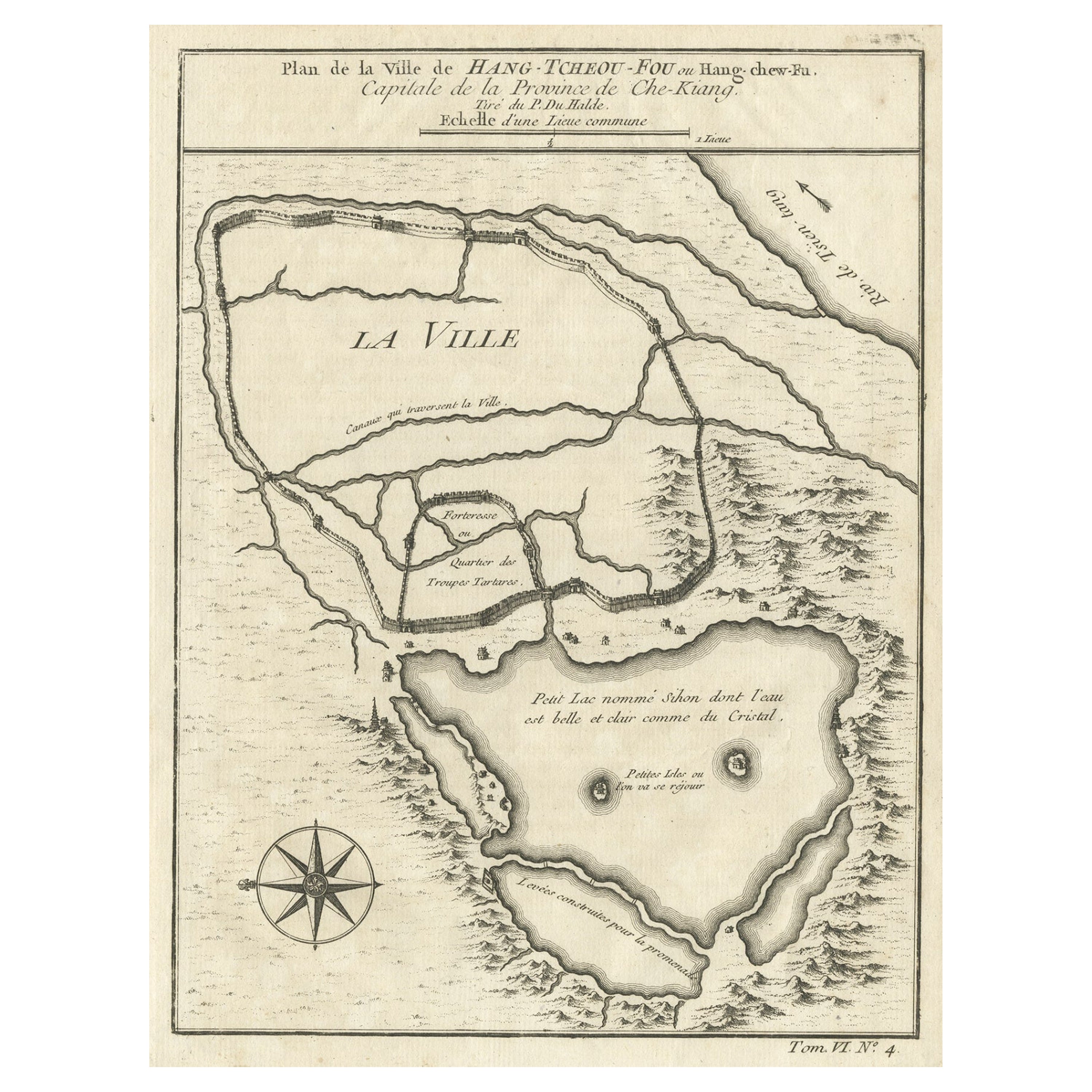
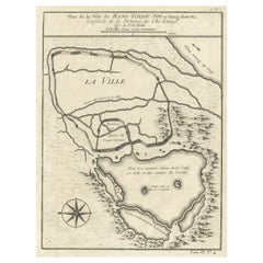
Antique Map of the City of Hangzhou by Bellin, 1748
By Jacques-Nicolas Bellin
Located in Langweer, NL
Antique map titled 'Plan de la ville de Hang-Tcheou-Fou ou Hang-Chew-Fu Capitale de la Province de Che-Kiang’. This original print shows a map of the city of Hangzhou, capital of the...
Category
Antique 18th Century Maps
Materials
Paper
$325 Sale Price
20% Off
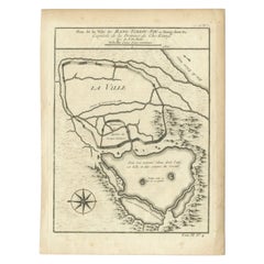
Antique Map of Hangzhou, Capital of the Province of Zheijang, China, 1748
Located in Langweer, NL
Antique map titled 'Plan de la ville de Hang-Tcheou-Fou ou Hang-Chew-Fu Capitale de la Province de Che-Kiang’.
This original print shows a map of the city of Hangzhou, capital of...
Category
Antique 1740s Maps
Materials
Paper
$325 Sale Price
20% Off
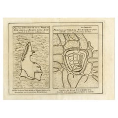
Antique Map of Cities Nanking and Suzhou in the Jiangsu Region, China, c.1758
Located in Langweer, NL
Antique map titled 'Plan de l' Enceinte de la Ville de Nan-King ou Kyang-Ning-Fou et plan de la ville de Su-Tcheou-Fou.' A map of the city of Nanking or Nanjing. A second map shows S...
Category
Antique 18th Century Maps
Materials
Paper
$229 Sale Price
20% Off
Antique Map of Cities in the Hubei and Hunan Provinces of China, 1755
By Jacques-Nicolas Bellin
Located in Langweer, NL
Antique print titled 'Plans de Quelques villes de la province de Hou-Quang.' Three bird's-eye view plans of walled cities in what are now China's Hubei (Hou-Quang) and Hunan Province...
Category
Antique 18th Century Maps
Materials
Paper

$277 Sale Price
20% Off
You May Also Like
1627 Hendrik Hondius Map Entitled "Vltoniae Orientalis Pars, " Ric.a009
Located in Norton, MA
1627 Hendrik Hondius map entitled
"Vltoniae orientalis pars,"
Ric.a009
Title:
Vltoniae orientalis : pars
Title (alt.) :
Ultoniae orientalis pars
Creator:
Mercator, Gerh...
Category
Antique 17th Century Dutch Maps
Materials
Paper

Original Antique Map of Switzerland, Engraved By Barlow, Dated 1807
Located in St Annes, Lancashire
Great map of Switzerland
Copper-plate engraving by Barlow
Published by Brightly & Kinnersly, Bungay, Suffolk.
Dated 1807
Unframed.
Category
Antique Early 1800s English Maps
Materials
Paper

Antique French Map of Asia Including China Indoneseia India, 1783
Located in Amsterdam, Noord Holland
Very nice map of Asia. 1783 Dedie au Roy.
Additional information:
Country of Manufacturing: Europe
Period: 18th century Qing (1661 - 1912)
Condition: Overall Condition B (Good Used)...
Category
Antique 18th Century European Maps
Materials
Paper

$648 Sale Price
20% Off
17th Century Topographical Map, Champagne-Ardenne, Marsal, Maubert Iohan Peeters
Located in New York, NY
Fine topographical 17th century map by Iohan Peeters of Marsal and Maubert Fontaine in the Champagne-Ardennes Region of North Eastern France.
Fabulous period engraving for a Wine Ce...
Category
Antique 17th Century Dutch Maps
Materials
Paper

17th Century Toulouse, Savve, Sommieres Topographical Map by Iohan Peeters
Located in New York, NY
Fine topographical 17th century map of Toulouse, Savve and Sommieres by Iohan Peeters
Beautiful engraving of the capital of France's Occitanie Region, Toulouse, called La Ville Rose- the Pink City, for the terracotta bricks used in its many buildings, giving the city a distinct apricot-rose hue. An important cultural and educational center, the city's residents included Nobel Prize winners and world renown artists- Henri de Toulouse-Lautrec, Henri Martin, Jean-Auguste-Dominique Ingres, Antonin Mercie, Alexandre Falguiere and more recently Cyril Kongo...
Category
Antique 17th Century Dutch Maps
Materials
Paper

17th-18th Century Siege of Graves Mapping Engraving By Willian III
Located in Kingston, NY
RARE French 17th-18th Century Enhanced Siege of Graves Mapping Engraving BY William III, also widely known as William of Orange,
The Siege of Grave in Dutch Brabant started by Monsie...
Category
Antique 17th Century French Prints
Materials
Paper

More Ways To Browse
China Engraving
17th Century Cherub
Antique China Porcelain Collectibles
Silk Map
Ming Dynasty Silk
Nieuhof China
Antique Oushak Carpets
Blue Coffee Tables
1945 Chair Juhl
Antique Three Leg Table
Folke Arstrom
Silver Over Copper
Vintage Barware Glasses
Antique Etched Glass
Antique French Shell
Coffee Table Black Italian Modern
Christofle America
Iranian Silk Rug Carpet