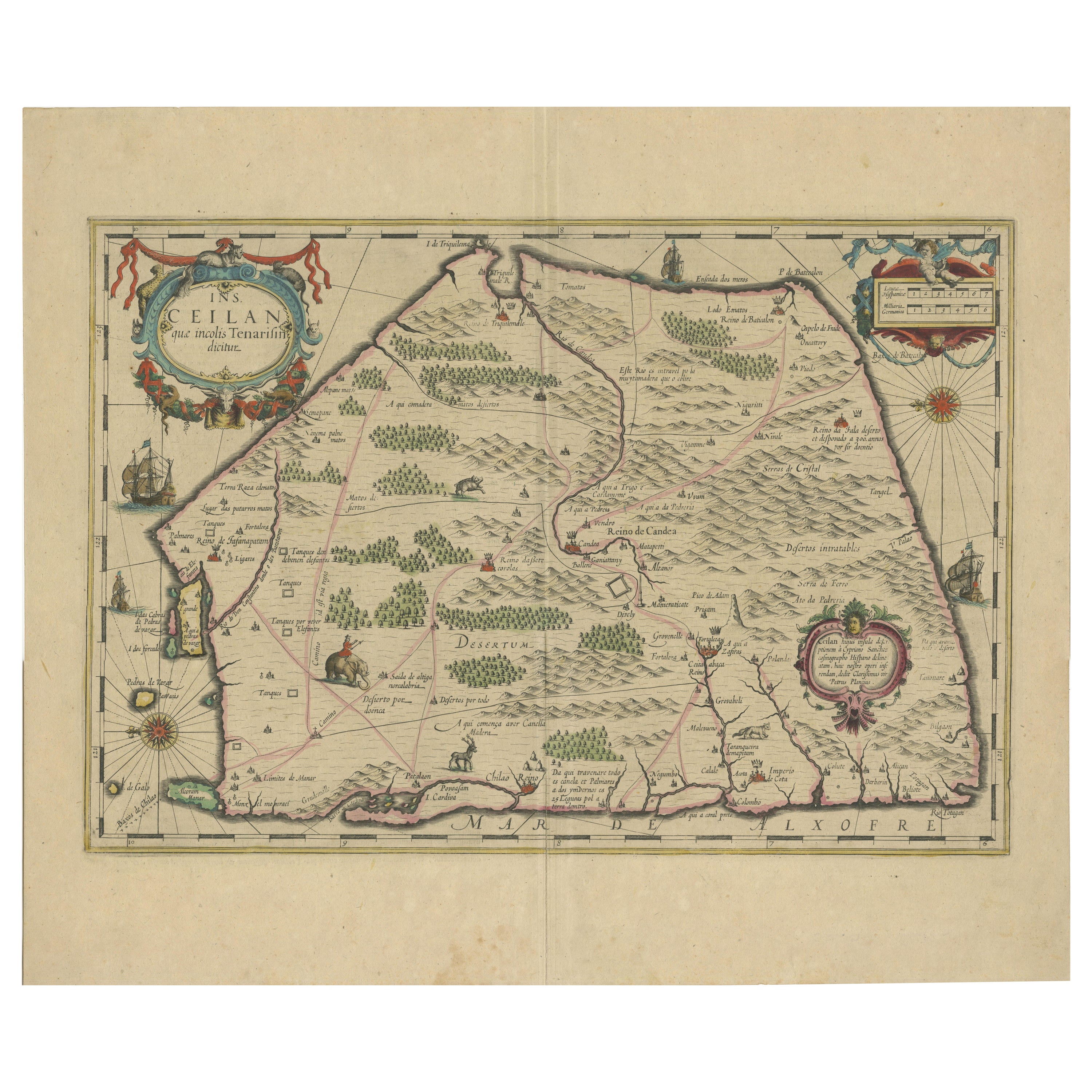
Items Similar to 17th-Century Map of Sri Lanka (Ceylon) by Mercator & van den Keere, 1630

Want more images or videos?
Request additional images or videos from the seller
1 of 7
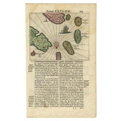
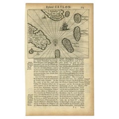
17th-Century Map of Sri Lanka (Ceylon) by Mercator & van den Keere, 1630
$563.61
£419.27
€470
CA$771.78
A$858.11
CHF 448.06
MX$10,445.35
NOK 5,717.05
SEK 5,356.61
DKK 3,577.85
Shipping
Retrieving quote...The 1stDibs Promise:
Authenticity Guarantee,
Money-Back Guarantee,
24-Hour Cancellation
About the Item
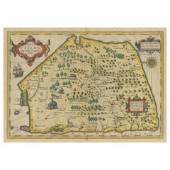
This captivating 17th-century map titled "Zeilan ou Ceilon Isle" (Ceylon/Sri Lanka) was engraved by Petrus Kaerius (van den Keere) and published in Mercator's "Atlas Minor," edited by Cloppenburgh. The map is an original antique copper plate engraving, hand-colored, and features French text on the verso. It provides a fascinating view of the island of Sri Lanka as understood in the early 1600s, with details of its regions, settlements, and natural features.
The map portrays Sri Lanka with a meticulous depiction of its mountains, rivers, and settlements, emphasizing the Kingdom of Kandy (Reino de Candea), among other notable regions. The cartouche is elegantly designed, and the hand coloring enhances the engraving's visual appeal, making it a beautiful piece of historical cartography. This map is an excellent example of European cartographic artistry and knowledge of South Asia during the 17th century.
Condition: The engraved image measures approximately 25 x 18.5 cm (9.75 x 7.25 inches) on a sheet of 26.5 x 21 cm (11 x 8.5 inches). The impression is crisp, with faint browning of the paper and minor chipping along the left edge, which does not affect the map's integrity or visual impact. Overall, the condition is very good for a map of this age.
Collectors and historians will appreciate this map for its historical significance, detailed depiction of 17th-century Sri Lanka, and connection to the renowned cartographers Gerard Mercator and Petrus Kaerius. It is a wonderful addition to any collection of antique maps, particularly those focused on South Asia or colonial cartography.
- Dimensions:Height: 8.47 in (21.5 cm)Width: 11.03 in (28 cm)Depth: 0.01 in (0.2 mm)
- Materials and Techniques:Paper,Engraved
- Period:1630-1639
- Date of Manufacture:1630
- Condition:The impression is crisp, with faint browning of the paper and minor chipping along the left edge, which does not affect the map's integrity or visual impact. Some soiling due to handling. Overall, the condition is very good for a map of this age.
- Seller Location:Langweer, NL
- Reference Number:Seller: BG-139201stDibs: LU3054342681492
About the Seller
5.0
Recognized Seller
These prestigious sellers are industry leaders and represent the highest echelon for item quality and design.
Platinum Seller
Premium sellers with a 4.7+ rating and 24-hour response times
Established in 2009
1stDibs seller since 2017
2,511 sales on 1stDibs
Typical response time: <1 hour
- ShippingRetrieving quote...Shipping from: Langweer, Netherlands
- Return Policy
Authenticity Guarantee
In the unlikely event there’s an issue with an item’s authenticity, contact us within 1 year for a full refund. DetailsMoney-Back Guarantee
If your item is not as described, is damaged in transit, or does not arrive, contact us within 7 days for a full refund. Details24-Hour Cancellation
You have a 24-hour grace period in which to reconsider your purchase, with no questions asked.Vetted Professional Sellers
Our world-class sellers must adhere to strict standards for service and quality, maintaining the integrity of our listings.Price-Match Guarantee
If you find that a seller listed the same item for a lower price elsewhere, we’ll match it.Trusted Global Delivery
Our best-in-class carrier network provides specialized shipping options worldwide, including custom delivery.More From This Seller
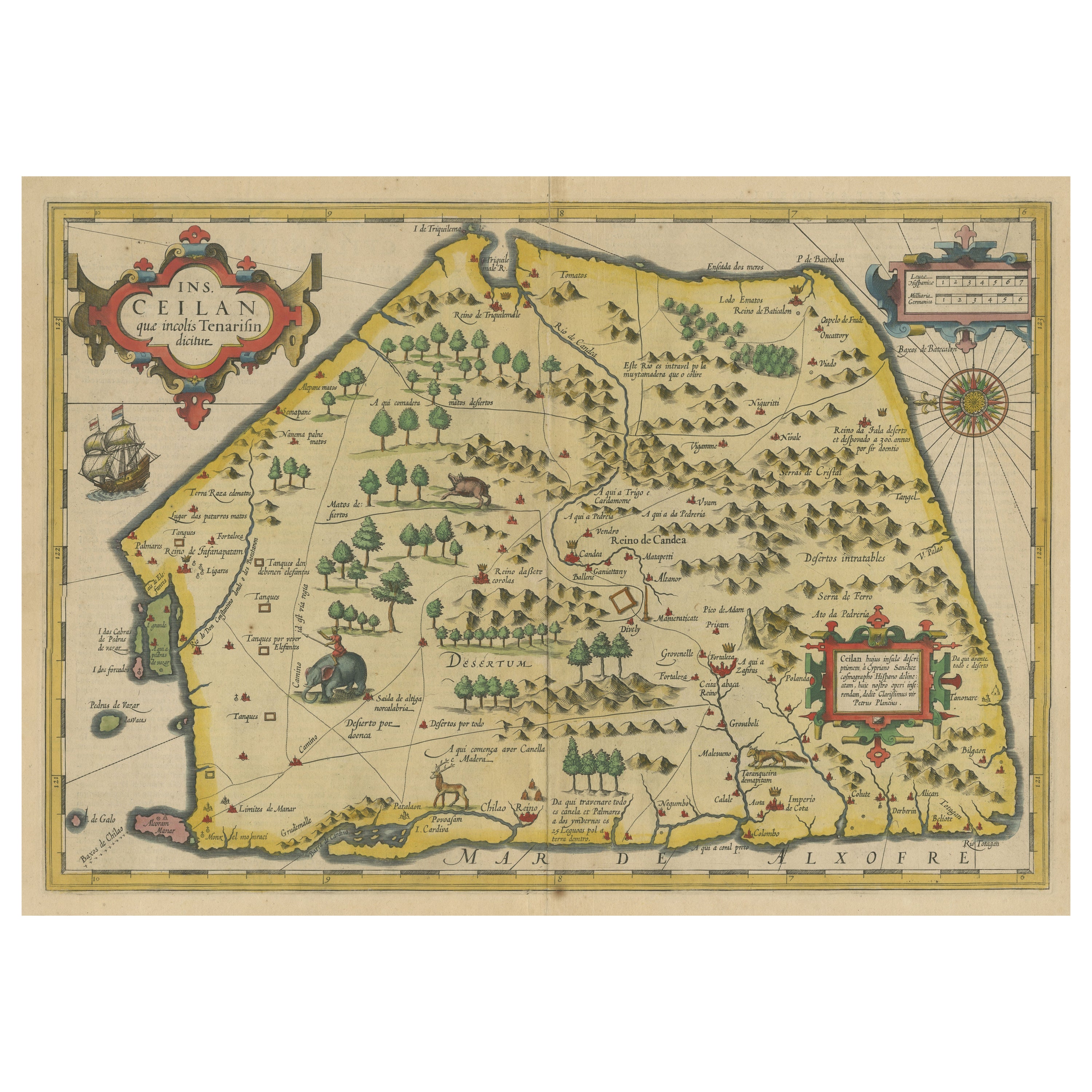
View AllAntique Map of Sri Lanka with an unusual five-sided shape, circa 1606
Located in Langweer, NL
Antique map titled 'Ins. Ceilan quae incolis Tenarisin dicitur'. This exquisite, early map of Sri Lanka is shown with an unusual five-sided shape. North is oriented to the left by an...
Category
Antique Early 17th Century Maps
Materials
Paper
$613 Sale Price
20% Off
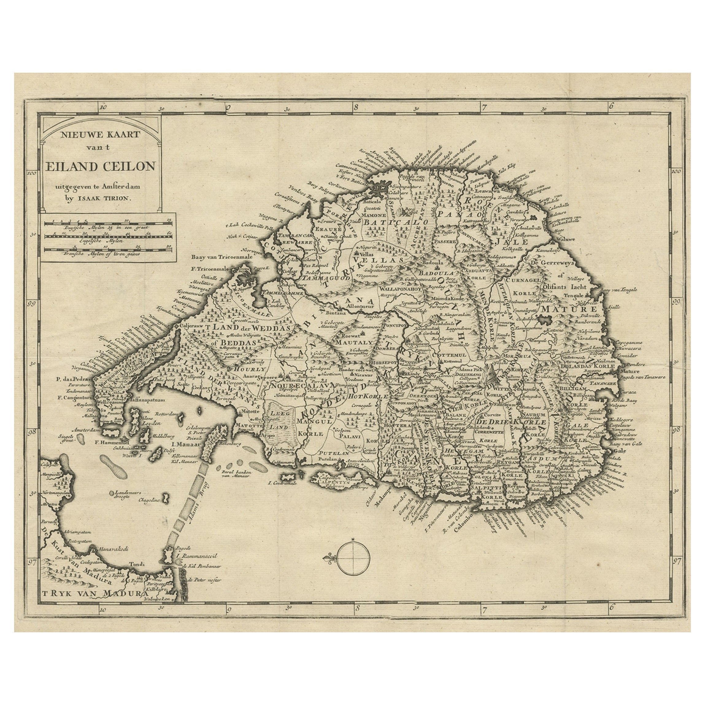
Old Map of Ceylon 'Sri Lanka' with The North Oriented to The Left, 1731
Located in Langweer, NL
Description: Antique map Ceylon titled 'Nieuwe Kaart van t Eland Ceilon'.
Old map of present-day Sri Lanka with north oriented to the left. The ...
Category
Antique 1730s Maps
Materials
Paper
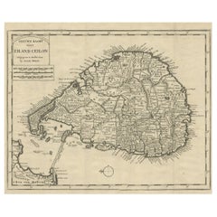
$623 Sale Price
20% Off
1638 Plancius Detailed Map of Sri Lanka or Ceylon with Decorative Cartouches
Located in Langweer, NL
"1638 Plancius Detailed Map of Sri Lanka with Decorative Cartouches"
This beautifully detailed map of Sri Lanka, titled "Ins. Ceilan," was engraved by P. Plancius from a design by C...
Category
Antique 1630s Maps
Materials
Paper
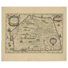
$1,381 Sale Price
20% Off
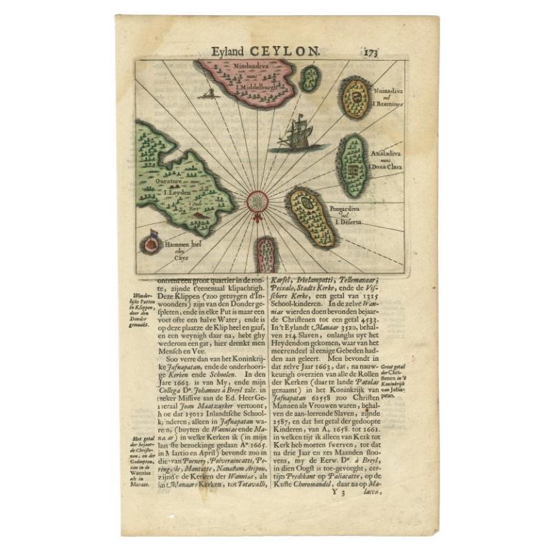
Antique 17th Century Map of the Islands Near Ceylon or Sri Lanka, 1672
Located in Langweer, NL
Antique map titled 'Eyland Ceylon.' Map of the islands near Ceylon or Sri Lanka. Dutch text on verso. Source unknown, to be determined.
Artists and Engravers: Philip Baldaeus (1632-...
Category
Antique 17th Century Maps
Materials
Paper
$239 Sale Price
20% Off
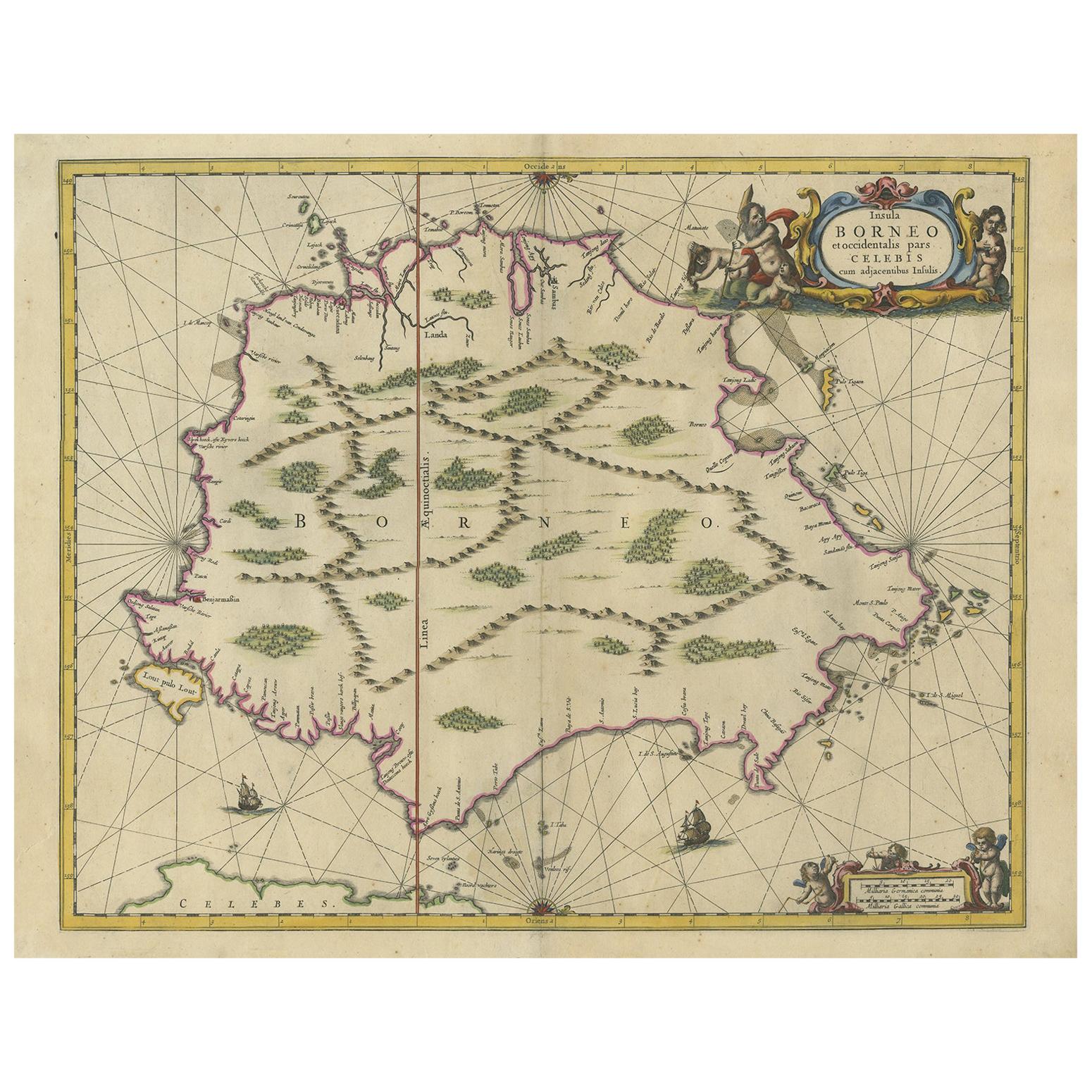
Antique Map of the Island of Borneo by Janssonius, circa 1650
Located in Langweer, NL
Antique map titled 'Insula Borneo et Occidentalis pars Celebis cum adjacentibus Insulis'. Rare sea chart of the island of Borneo. Published by J. Janssonius, circa 1650.
Category
Antique Mid-17th Century Maps
Materials
Paper

$1,768 Sale Price
24% Off
Antique Map of the Islands Near Ceylon by Baldaeus, 1672
By Philip Baldaeus
Located in Langweer, NL
Antique print, untitled. This original antique print shows the islands Leyden, Middelburg, Hammenhiel, Bramines, Dona Clara and Deserta near Ceylon / Sri Lanka, with their Dutch name...
Category
Antique 17th Century Maps
Materials
Paper
$119 Sale Price
20% Off
You May Also Like
Ancient Map - Zeilan - Etching by Johannes Janssonius - 1650s
By Johannes Janssonius
Located in Roma, IT
Ancient Map - Zeilan is an ancient map realized in 1650 by Johannes Janssonius (1588-1664).
The Map is Hand-colored etching, with coeval watercoloring.
...
Category
1650s Modern Figurative Prints
Materials
Etching

Northern Scotland: A 17th Century Hand-colored Map by Mercator
By Gerard Mercator
Located in Alamo, CA
This is a framed hand-colored 17th century map of Northern Scotland by Gerard Mercator entitled "Scotiae pars Septentrionalis", published in Amsterdam in 1636. It is a highly detailed map of the northern part of Scotland, with the northwest Highlands and the cities Inverness and Aberdeen, as well as the Orkney Islands and the Hebrides. There is a decorative title cartouche in the upper left corner.
The map is presented in an antiqued brown wood...
Category
Antique 1630s Dutch Maps
Materials
Paper

Southern Greece: A Large 17th C. Hand-colored Map by Sanson and Jaillot
By Nicolas Sanson
Located in Alamo, CA
This large original hand-colored copperplate engraved map of southern Greece and the Pelopponese Peninsula entitled "La Moree Et Les Isles De Zante, Cefalonie, Ste. Marie, Cerigo & C...
Category
Antique 1690s French Maps
Materials
Paper

1633 Map Entitled "Beauvaisis Comitatus Belova Cium, Ric.0002
Located in Norton, MA
1633 map entitled
"Beauvaisis Comitatus Belova Cium,"
Hand Colored
Ric.0002
Description: Cartographer : - Hondius, Henricus 1587-1638
Artists and Engravers:Jodocus Hondius, one of the most notable engravers of his time. He is known for his work in association with many of the cartographers and publishers prominent at the end of the sixteenth and the beginning of the seventeenth century. A native of Flanders, he grew up in Ghent, apprenticed as an instrument and globe maker and map engraver. In 1584, to escape the religious troubles sweeping the Low Countries at that time, he fled to London where he spent some years before finally settling in Amsterdam about 1593. In the London period he came into contact with the leading scientists and geographers of the day and engraved maps in The Mariner\\\\\\\\\\\\\\\'s Mirrour, the English edition of Waghenaer\\\\\\\\\\\\\\\'s Sea Atlas, as well as others with Pieter van den Keere, his brother-in-law. No doubt his temporary exile in London stood him in good stead, earning him an international reputation, for it could have been no accident that Speed chose Hondius to engrave the plates for the maps in The Theatre of the Empire of Great Britaine in the years between 1605 and 1610. In 1604 Hondius bought the plates of Mercator\\\\\\\\\\\\\\\'s Atlas which, in spite of its excellence, had not competed successfully with the continuing demand for the Ortelius Theatrum Orbis Terrarum. To meet this competition Hondius added about 40 maps to Mercator\\\\\\\\\\\\\\\'s original number and from 1606 published enlarged editions in many languages, still under Mercator\\\\\\\\\\\\\\\'s name but with his own name as publisher. These atlases have become known as the Mercator/Hondius series. The following year the maps were reengraved in miniature form and issued as a pocket Atlas Minor. After the death of Jodocus Hondius the Elder in 1612, work on the two atlases, folio and miniature, was carried on by his widow and sons, Jodocus II and Henricus, and eventually in conjunction with Jan Jansson in Amsterdam.
In all, from 1606 onwards, nearly 50 editions with increasing numbers of maps with texts in the main European languages were printed. Summaries of these issues are given under the entry for Gerard Mercator. Jodocus Hondius the Elder * 1588 Maps in The Mariner\\\\\\\\\\\\\\\'s Mirrour (Waghenaer/Ashley) * 1590 World Map...
Category
Antique 17th Century Dutch Maps
Materials
Paper

Northern Scotland: A 16th Century Hand-colored Map by Mercator
By Gerard Mercator
Located in Alamo, CA
A framed hand-colored 16th century map of Northern Scotland by Gerard Mercator entitled "Scotiae pars Septentrionalis", published in Amsterdam in 1636. It is a highly detailed map of the northern part of Scotland, with the northwest Highlands and the cities Inverness and Aberdeen, as well as the Orkney Islands and the Hebrides. There is a decorative title cartouche in the upper left corner.
The map is presented in an antiqued brown wood...
Category
Antique 16th Century Dutch Maps
Materials
Paper
West Africa: A 17th Century Hand-Colored Map by Mercator/Hondius
By Gerard Mercator
Located in Alamo, CA
A 17th century hand-colored map entitled "Guineae Nova Descriptio" by Gerard Mercator and Jodocus Hondius, published in their 'Atlas Minor' in Amsterdam in 1635. It is focused on the...
Category
1630s Landscape Prints
Materials
Engraving

More Ways To Browse
Ceylon Furniture
Colonial Sri Lankan
Red Retro Dining Set
Antique Silver Glasses Case
Carlo Scarpa 1934 Chairs
Christofle Marly
1900 Antique Chairs
Glass Table Italian Round
Mid Century Colonial
Alvar Aalto Poster
Geometric Metal Table
Post Modern High Chairs
United Nations
Vintage Vine Rug
Cancel An Order
Antique Framing Square
Silver Metal Chair
Swedish Kilim