Items Similar to 1802 German Map of Kashmir and Surrounding Regions by Weimar, Based on Gentil


Want more images or videos?
Request additional images or videos from the seller
1 of 10
1802 German Map of Kashmir and Surrounding Regions by Weimar, Based on Gentil
$367.53
£275.06
€310
CA$507.05
A$563.86
CHF 296.15
MX$6,893.71
NOK 3,690.31
SEK 3,478.96
DKK 2,359.87
About the Item
Title: 1802 German Map of Kashmir and Surrounding Regions by Weimar, Based on Gentil
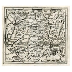
Description: This rare and finely detailed antique map, titled Charte von Kaschemir, was published in 1802 in Weimar and is based on descriptions from the French officer and geographer Jean-Baptiste-Joseph Gentil. It provides an early European representation of the Kashmir Valley and surrounding territories, including parts of modern-day Pakistan, Tibet, and northern India. This map reflects the growing European interest in the Indian subcontinent during the late 18th and early 19th centuries, particularly as colonial ambitions expanded and geographic knowledge improved.
Jean-Baptiste-Joseph Gentil was a French officer who served at the court of the Nawabs of Awadh, where he conducted diplomatic and geographical studies of India. His accounts significantly influenced European cartographers, and this map is one of the products of those efforts. The German-language title and text suggest that it was intended for a scholarly European audience, likely included in a larger work on Hindustan or Asian geography.
The map meticulously details the mountain ranges, rivers, lakes, and settlements of Kashmir. Notable features include Dal Lake, marked as Dall See, the city of Srinagar, labeled as Kaschemir, and the surrounding Himalayan mountain ranges, labeled as Gross Thibet, meaning Greater Tibet, and Klein Thibet, meaning Little Tibet. The terrain is illustrated with hachure lines, a cartographic technique used to depict elevation and rugged landscapes. Political and regional boundaries are marked, including those of Lahore, Pader, and Sind, reflecting the shifting territorial claims of the period.
This map is an excellent example of early nineteenth-century European cartography, reflecting an era when European powers sought to expand their knowledge of South Asia for both scholarly and colonial purposes. The Weimar publishing house, known for its high-quality engravings, produced this map with precision, ensuring a balance between scientific accuracy and artistic elegance.
Cartographer and Source:
This map was published by the Weimar publishing house in 1802, based on earlier descriptions recorded by Jean-Baptiste-Joseph Gentil. Gentil was a French military officer and geographer who compiled detailed accounts of Hindustan while serving under the Nawabs of Awadh. His geographical studies helped expand European knowledge of India, Tibet, and Central Asia.
Condition Report:
The paper is well-preserved, showing the characteristic laid texture and chain lines of early nineteenth-century European printing. The engraving remains sharp and detailed, with clear labels and finely executed hachure lines that emphasize the mountainous terrain.
There is minor foxing and light age-toning, especially along the edges, which is typical for antique maps of this period. The central fold is original, with a slight crease along the fold line. The margins remain intact with only minor edge wear. There are no major tears, repairs, or stains, making this map a very fine example of its type and age.
Framing Recommendations:
To preserve and enhance the presentation of this antique map, it is recommended to use museum-quality archival materials.
For matting and backing, use acid-free, museum-grade board to prevent further aging. A double mat with a neutral outer mat and an inner accent in soft beige or gray will enhance the fine details of the engraving.
A classic black, dark walnut, or gilded wooden frame will complement the historical aesthetic of the piece. An antique-style frame with subtle carvings can further enhance its period charm.
To protect the map, UV-resistant museum glass or acrylic is advised to prevent fading. Anti-reflective glass will ensure clarity while maintaining the engraving’s full visibility.
For mounting, avoid adhesives directly on the paper. Instead, use archival-quality corner mounts or Japanese paper hinges to secure the map safely.
The framed map should be displayed in a controlled environment, away from direct sunlight, humidity, and extreme temperature changes. Ideal locations include a study, library, or gallery, where the historical and artistic value of this piece can be fully appreciated.
This 1802 map of Kashmir is a remarkable historical artifact that captures European attempts to understand the geography of South Asia and the Himalayas. It is a valuable addition to any collection focused on Indian history, early European maps of Asia, or nineteenth-century cartography.
- Dimensions:Height: 7.17 in (18.2 cm)Width: 10.32 in (26.2 cm)Depth: 0.01 in (0.2 mm)
- Materials and Techniques:Paper,Engraved
- Period:
- Date of Manufacture:1802
- Condition:Good with minor foxing and light age-toning, especially along the edges, which is typical for antique maps of this period. Sharp details. The two folds are original. The low border is cut short.
- Seller Location:Langweer, NL
- Reference Number:Seller: BG-035571stDibs: LU3054343931162
About the Seller
5.0
Recognized Seller
These prestigious sellers are industry leaders and represent the highest echelon for item quality and design.
Platinum Seller
Premium sellers with a 4.7+ rating and 24-hour response times
Established in 2009
1stDibs seller since 2017
2,607 sales on 1stDibs
Typical response time: <1 hour
- ShippingRetrieving quote...Shipping from: Langweer, Netherlands
- Return Policy
Authenticity Guarantee
In the unlikely event there’s an issue with an item’s authenticity, contact us within 1 year for a full refund. DetailsMoney-Back Guarantee
If your item is not as described, is damaged in transit, or does not arrive, contact us within 7 days for a full refund. Details24-Hour Cancellation
You have a 24-hour grace period in which to reconsider your purchase, with no questions asked.Vetted Professional Sellers
Our world-class sellers must adhere to strict standards for service and quality, maintaining the integrity of our listings.Price-Match Guarantee
If you find that a seller listed the same item for a lower price elsewhere, we’ll match it.Trusted Global Delivery
Our best-in-class carrier network provides specialized shipping options worldwide, including custom delivery.More From This Seller
View AllAntique Map of Switzerland by Keizer & de Lat, 1788
Located in Langweer, NL
Antique map titled 'La Suisse (..)'. Uncommon original antique map of Switzerland. This map originates from 'Nieuwe Natuur- Geschied- en Handelkundige Zak- en Reisatlas' by Gerrit Br...
Category
Antique Late 18th Century Maps
Materials
Paper

$331 Sale Price
20% Off
Antique Map of Upper Saxony in Germany by Clouet, 1787
Located in Langweer, NL
Antique map titled 'Du Cercle de Haute Saxe'. Antique map of Upper Saxony, Germany. Originates from 'Geographie moderne avec une introduction' by J.B.L. Clouet.
Category
Antique Late 18th Century Maps
Materials
Paper
$284 Sale Price
20% Off
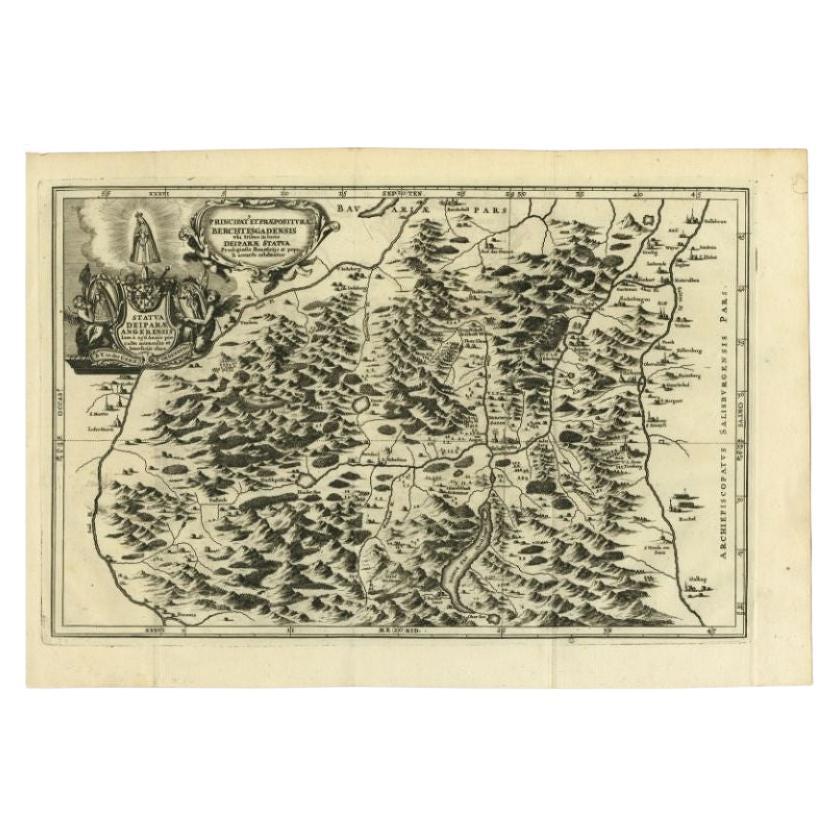
Antique Map of the Berchtesgaden Region by Scherer, 1699
Located in Langweer, NL
Antique map titled 'Principat et praepositura Berchtesgadensis (..).' Detailed uncommon map of the Berchtesgaden region in southern Bavaria, Germany. Source unknown, to be determined...
Category
Antique 17th Century Maps
Materials
Paper

$213 Sale Price
20% Off
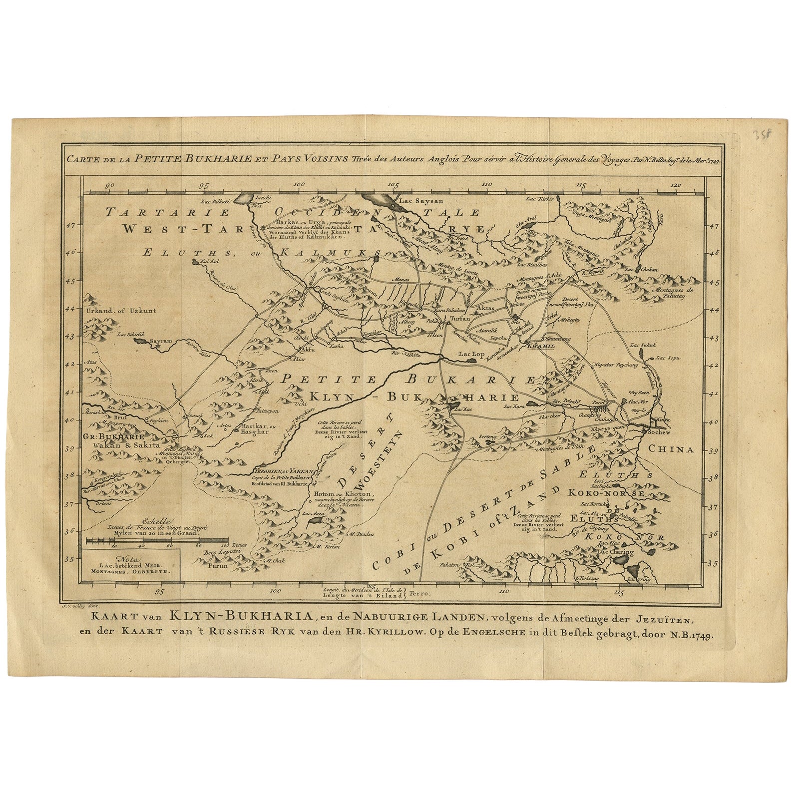
Antique Map of Turkmenistan, Uzbekistan, Tajikistan and Kyrgyzstan, 1749
Located in Langweer, NL
Antique map titled ‘Carte de la Petite Bukharie et Pays Voisins – Tirée des Auteurs Anglois pour server a l ‘Histoire Generale des Voyages. Par N. Bellin Ing. D la Mar. 1749.’ Dutch title: ‘Kaart van Klyn-Bukharia, en de Nabuurige Landen, volgens de Afmeetinge der Jezuïten, en der Kaart van ’t Russiese Ryk van den Hr. Kyrillow. Op de Engelsche in dit Bestek gebragt door N.B. 1749’.
An attractive mid-18th century French black and white map...
Category
Antique 18th Century Maps
Materials
Paper

$379 Sale Price
20% Off
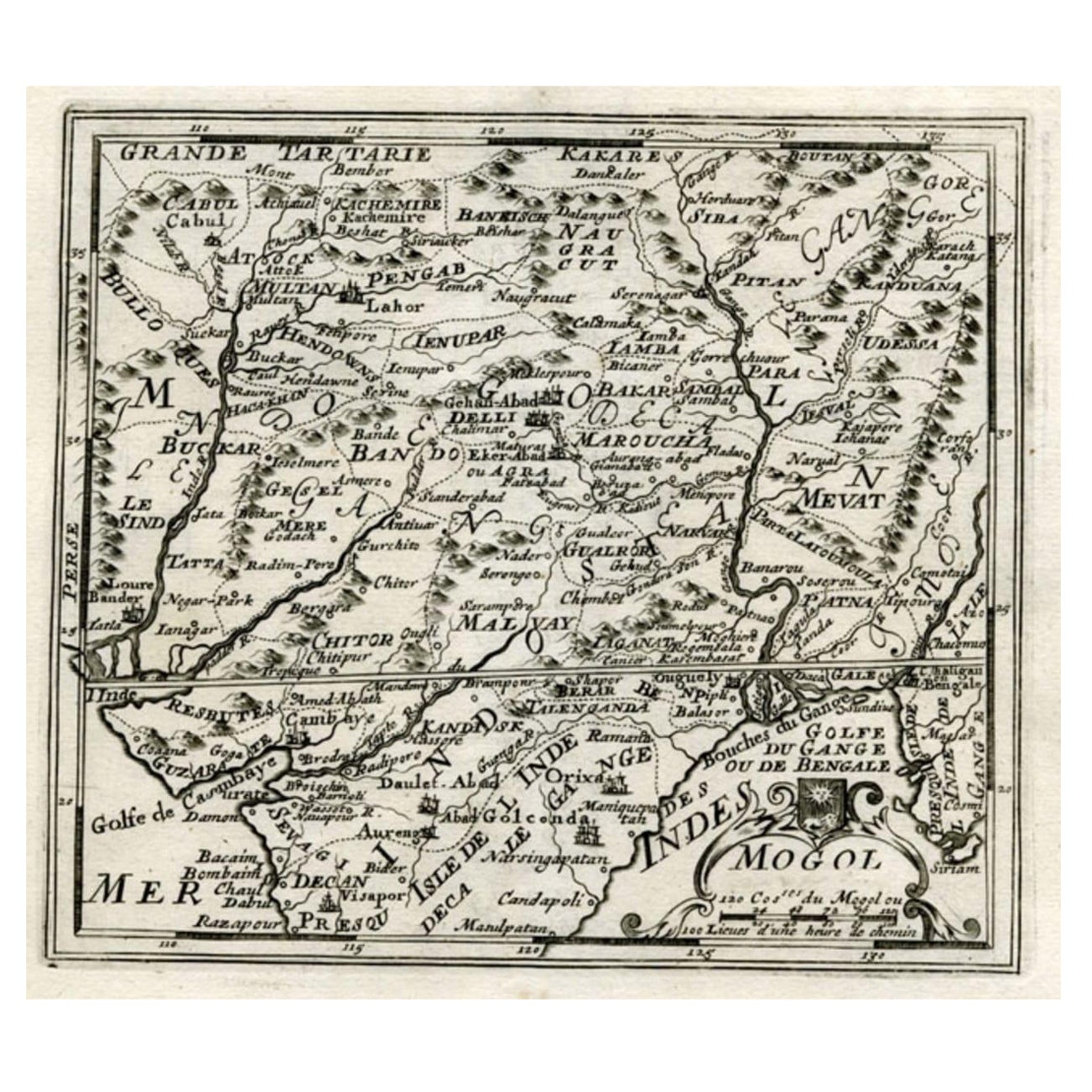
Map of Northern India and Pakistan 'Mogol', Showing Kabul, Delhi Etc., 1758
Located in Langweer, NL
Antique map titled 'Mogol'.
Map of Northern India and Pakistan ('Mogol'), showing Kabul, Delhi and surroundings. This map originates from 'Kort begrip der Oude en Nieuwe Staatkun...
Category
Antique 1750s Maps
Materials
Paper
$350 Sale Price
20% Off
Antique Map of Austria by N. Visscher, circa 1690
Located in Langweer, NL
Antique map titled 'Austriae Archiducatus pars superior in omnes ejusdem'. Spectacular large map of Upper and Lower Austria between Passau and Wien with figurative cartouche and armo...
Category
Antique Late 17th Century Maps
Materials
Paper

$882 Sale Price
20% Off
You May Also Like
1839 Map of Karte Des "Russischen Reiches in Europa Und Asien" Ric.R0013
Located in Norton, MA
1839 map of Karte Des
"Russischen Reiches in Europa and Asien"
Ric.r013
Map of the European and Asian parts of Russian Empire. Karte der Russischen Reiches in Europa und Asien...
Category
Antique 19th Century Unknown Maps
Materials
Paper

Original Antique Map of Switzerland, Engraved By Barlow, Dated 1807
Located in St Annes, Lancashire
Great map of Switzerland
Copper-plate engraving by Barlow
Published by Brightly & Kinnersly, Bungay, Suffolk.
Dated 1807
Unframed.
Category
Antique Early 1800s English Maps
Materials
Paper

1790 Thomas Stackhouse Map, Entitled "Russia in Europe, " , Ric.a004
Located in Norton, MA
1790 Thomas Stackhouse map, entitled
"Russia in Europe"
Ric.a004
Stackhouse, Thomas
Russia in Europe [map]
London: T. Stackhouse, 1783. Map. Matted hand-colored copper engraving. Image size: 14.5 x 15.25 inches. Mat size: 22.75 x 23.75 inches. A beautiful example of this map of Eastern Europe...
Category
Antique 17th Century Unknown Maps
Materials
Paper

1657 Janssonius Map of Vermandois and Cappelle, Ric. A-004
Located in Norton, MA
1657 Janssonius map of
Vermandois and Cappelle
Ric.a004
Description: Antique map of France titled 'Descriptio Veromanduorum - Gouvernement de la Cappelle'. Two detailed maps o...
Category
Antique 17th Century Unknown Maps
Materials
Paper

Original Antique Map of Ancient Greece, Achaia, Corinth, 1786
Located in St Annes, Lancashire
Great map of Ancient Greece. Showing the region of Thessaly, including Mount Olympus
Drawn by J.D. Barbie Du Bocage
Copper plate engraving by P.F Tardieu
Original hand color...
Category
Antique 1780s French Other Maps
Materials
Paper

Original Antique Map of Ancient Greece- Boeotia, Thebes, 1787
Located in St Annes, Lancashire
Great map of Ancient Greece. Showing the region of Boeotia, including Thebes
Drawn by J.D. Barbie Du Bocage
Copper plate engraving by P.F T...
Category
Antique 1780s French Other Maps
Materials
Paper

More Ways To Browse
Antique Kashmir
Kashmir Antique Furniture
German Colonial
Himalayan Antique
Vintage Scandanavian Chairs
19th Century Red Glass
Antique French Console Table Tables
Silver Bowl Large
Antique French Silk
Down Couch
Used Lighter Art
Blue Edge Glass
Mahogany 1950s Furniture
Solid Mahogany Table
Dessert Glasses
Geometric Glass Table
Mid Century Pin
6x10 Rug