Items Similar to Original Antique Map of Ancient Greece, Achaia, Corinth, 1786


Want more images or videos?
Request additional images or videos from the seller
1 of 5
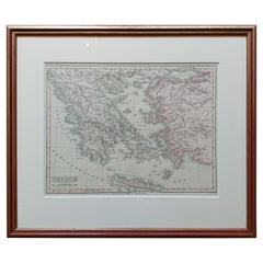
Original Antique Map of Ancient Greece, Achaia, Corinth, 1786
About the Item
Great map of Ancient Greece. Showing the region of Thessaly, including Mount Olympus
Drawn by J.D. Barbie Du Bocage
Copper plate engraving by P.F Tardieu
Original hand color outline.
Published 1786
Unframed.
- Dimensions:Height: 10 in (25.4 cm)Width: 14 in (35.56 cm)Depth: 0.07 in (1.78 mm)
- Style:Other (In the Style Of)
- Materials and Techniques:Paper,Other
- Place of Origin:
- Period:1780-1789
- Date of Manufacture:1786
- Condition:Wear consistent with age and use.
- Seller Location:St Annes, GB
- Reference Number:1stDibs: LU1836324413642
About the Seller
4.9
Platinum Seller
These expertly vetted sellers are 1stDibs' most experienced sellers and are rated highest by our customers.
1stDibs seller since 2016
2,757 sales on 1stDibs
Typical response time: 1 hour
Associations
International Confederation of Art and Antique Dealers' Associations
- ShippingRetrieving quote...Ships From: St Annes, United Kingdom
- Return PolicyA return for this item may be initiated within 3 days of delivery.
Auctions on 1stDibs
Our timed auctions are an opportunity to bid on extraordinary design. We do not charge a Buyer's Premium and shipping is facilitated by 1stDibs and/or the seller. Plus, all auction purchases are covered by our comprehensive Buyer Protection. Learn More
Authenticity Guarantee
In the unlikely event there’s an issue with an item’s authenticity, contact us within 1 year for a full refund. DetailsMoney-Back Guarantee
If your item is not as described, is damaged in transit, or does not arrive, contact us within 7 days for a full refund. Details24-Hour Cancellation
You have a 24-hour grace period in which to reconsider your purchase, with no questions asked.Vetted Professional Sellers
Our world-class sellers must adhere to strict standards for service and quality, maintaining the integrity of our listings.Price-Match Guarantee
If you find that a seller listed the same item for a lower price elsewhere, we’ll match it.Trusted Global Delivery
Our best-in-class carrier network provides specialized shipping options worldwide, including custom delivery.More From This Seller
View AllOriginal Antique Map of Ancient Greece, Phocis, Gulf of Corinth, 1787
Located in St Annes, Lancashire
Great map of Ancient Greece. Showing the region of Phocis, including the Gulf of Corinth
Drawn by J.D. Barbie Du Bocage
Copper plate engraving by P.F Tardieu
Original hand c...
Category
Antique 1780s French Other Maps
Materials
Paper

Original Antique Map of Ancient Greece- Boeotia, Thebes, 1787
Located in St Annes, Lancashire
Great map of Ancient Greece. Showing the region of Boeotia, including Thebes
Drawn by J.D. Barbie Du Bocage
Copper plate engraving by P.F T...
Category
Antique 1780s French Other Maps
Materials
Paper

Original Antique Map of South America, circa 1830
Located in St Annes, Lancashire
Great map of South America
Copper plate engraving
Published by Butterworth, Livesey & Co., circa 1830
Unframed.
Category
Antique Early 1800s English Other Maps
Materials
Paper

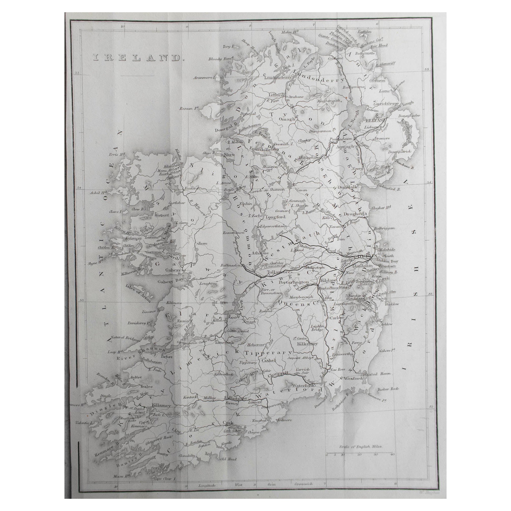
Original Antique Map of Ireland by Hughes. C.1850
Located in St Annes, Lancashire
Great map of Ireland
Engraved by W.Hughes
Published by Virtue, C.1850
Unframed.
Category
Antique 1850s Scottish Other Maps
Materials
Paper
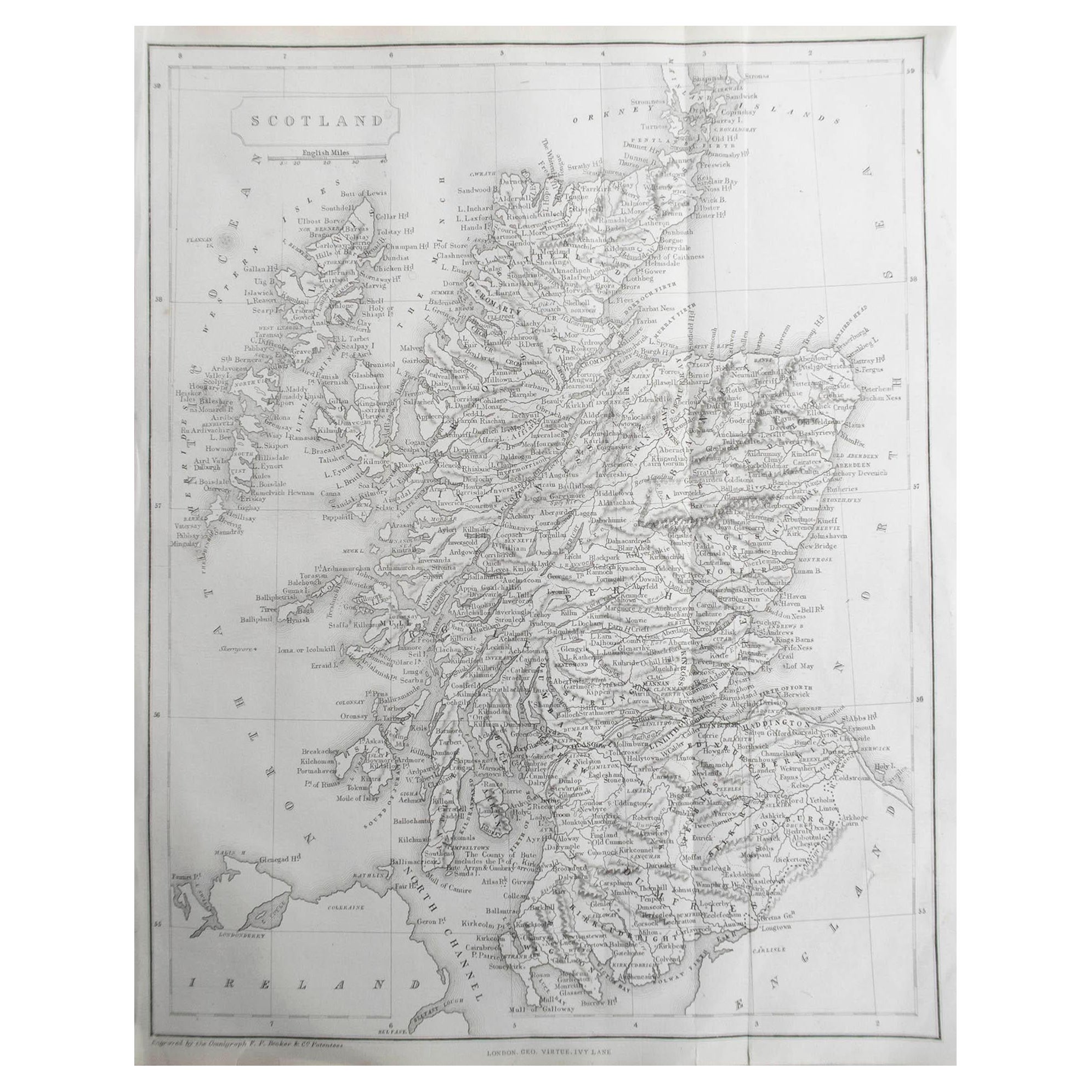
Original Antique Map of Scotland by Becker. C.1850
Located in St Annes, Lancashire
Great map of Scotland
Engraved by F.P Becker
Published by Virtue, C.1850
Unframed.
Category
Antique 1850s Scottish Other Maps
Materials
Paper

Original Antique Map of Spain and Portugal, circa 1790
Located in St Annes, Lancashire
Super map of Spain and Portugal
Copper plate engraving by A. Bell
Published, circa 1790.
Unframed.
Category
Antique 1790s English Other Maps
Materials
Paper

You May Also Like
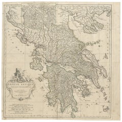
Large Scale Map of Greece with Inset Map of Macedonia, c.1786
Located in Langweer, NL
Antique map titled 'Graeciae Antiquae'. Large scale map of Greece, extends south to the island of Cythera. Inset map shows details of Macedonia. Publis...
Category
Antique 18th Century Maps
Materials
Paper

Original Antique Map of Ancient Asia, 1847
Located in Langweer, NL
Description: Antique map Asia titled 'Asie Ancienne'.
This is an original antique map of Ancient Asia and originates from 'Atlas de la Geographie ...
Category
Antique 1840s Maps
Materials
Paper

Antique Map of Europe by Krevelt '1786'
Located in Langweer, NL
Antique map titled 'Nieuwe Generale Kaart van Europa (..)'. Original antique map of Europe. This map originates from 'Compleete zak-atlas, van de...
Category
Antique Late 18th Century Maps
Materials
Paper
Original Antique Map of Greece and part of Turkey
Located in Langweer, NL
Original antique map titled 'La Grece ou partie meridionale de la Turquie d'Europe'. Small map of Greece and part of Turkey. This map originates from 'Le nouveau et curieux Atlas Geo...
Category
Antique Early 18th Century Maps
Materials
Paper

Large Scale Map of Greece, Extending to Cythera with Inset of Macedonia, ca.1786
Located in Langweer, NL
Antique map titled 'Graeciae Antiquae'.
Large scale map of Greece, extends south to the island of Cythera. Inset map shows details of Macedonia. Pu...
Category
Antique 1780s Maps
Materials
Paper
Original Antique Map in Frame of Greece by Smith '1818'
Located in Langweer, NL
Nicely framed map titled 'Greece'. Original antique map of Greece published by C. Smith, 1818. Frame included.
Category
Antique Early 19th Century Maps
Materials
Paper
$310 Sale Price
20% Off