Items Similar to 1811 John Cary Map of Lower Saxony - Featuring Bremen, Holstein, and More


Want more images or videos?
Request additional images or videos from the seller
1 of 6
1811 John Cary Map of Lower Saxony - Featuring Bremen, Holstein, and More
$622.82
£461.55
€520
CA$850.27
A$945.90
CHF 495.85
MX$11,558.61
NOK 6,314.03
SEK 5,943.79
DKK 3,959.23
Shipping
Retrieving quote...The 1stDibs Promise:
Authenticity Guarantee,
Money-Back Guarantee,
24-Hour Cancellation
About the Item
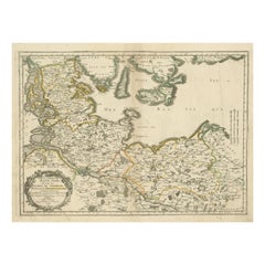
Title: "1811 John Cary Map of Lower Saxony - Featuring Bremen, Holstein, and More"
Description: This is an exquisite map of the Lower Saxony region, created by the renowned cartographer John Cary in 1811. Covering the Duchies of Bremen, Holstein, Mecklenburg, and Saxe Lauenburg, as well as the Principalities of Lüneburg, Calenberg, Wolfenbüttel, and Magdeburg, this map is an elegant depiction of early 19th-century Germany.
The map features detailed hand-coloring according to regional boundaries, showcasing forests, cities, palaces, forts, roads, rivers, and even offshore sandbars. The meticulous engraving highlights the geography and political divisions of the time, providing a fascinating glimpse into this historically significant region. Cary's craftsmanship and attention to detail make this map a visually captivating piece.
This map was originally published in Cary's "Universal Atlas," known for its precision and aesthetic quality, and is considered one of the most attractive atlas maps of Lower Saxony to emerge in the early 1800s. Its rich history and visual appeal make it an excellent collectible for those interested in cartography or German history.
The condition of this map appears to be very good for its age. The hand-coloring remains vibrant, and the engraving lines are clear and sharp. There is general age toning across the sheet, typical for a map of this period, but no significant tears or stains are visible. The paper edges show only minor wear, and there are no apparent folds or watermarks affecting the main image. Overall, this is a well-preserved example of John Cary's work, suitable for both display and collection purposes.
- Dimensions:Height: 21.46 in (54.5 cm)Width: 25.2 in (64 cm)Depth: 0.01 in (0.2 mm)
- Materials and Techniques:Paper,Engraved
- Period:
- Date of Manufacture:1811
- Condition:Very good for its age. The hand-coloring remains vibrant, and the engraving lines are clear and sharp. There is general age toning across the sheet, typical for a map of this period, but no significant tears or stains are visible.
- Seller Location:Langweer, NL
- Reference Number:Seller: BG-13842-191stDibs: LU3054342584402
About the Seller
5.0
Recognized Seller
These prestigious sellers are industry leaders and represent the highest echelon for item quality and design.
Platinum Seller
Premium sellers with a 4.7+ rating and 24-hour response times
Established in 2009
1stDibs seller since 2017
2,494 sales on 1stDibs
Typical response time: 1 hour
- ShippingRetrieving quote...Shipping from: Langweer, Netherlands
- Return Policy
Authenticity Guarantee
In the unlikely event there’s an issue with an item’s authenticity, contact us within 1 year for a full refund. DetailsMoney-Back Guarantee
If your item is not as described, is damaged in transit, or does not arrive, contact us within 7 days for a full refund. Details24-Hour Cancellation
You have a 24-hour grace period in which to reconsider your purchase, with no questions asked.Vetted Professional Sellers
Our world-class sellers must adhere to strict standards for service and quality, maintaining the integrity of our listings.Price-Match Guarantee
If you find that a seller listed the same item for a lower price elsewhere, we’ll match it.Trusted Global Delivery
Our best-in-class carrier network provides specialized shipping options worldwide, including custom delivery.More From This Seller
View AllAntique Map of Franconia, a region of Germany, '1811'
By John Cary
Located in Langweer, NL
Antique map titled 'A New Map of the Circle of Franconia'. Detailed map of Franconia in Northwestern Germany. Covers from Upper Saxony south to Swabia, west to the Lower Rhine and we...
Category
Antique Early 19th Century Maps
Materials
Paper

$239 Sale Price
20% Off
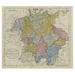
Antique Map of Lower Saxony in Germany, c.1740
Located in Langweer, NL
Antique map titled 'Nieuwe Kaart van de Neder Saxise Kreits (..).' Attractive detailed map showing Lower Saxony, Germany, including Mekelenburg, Lauwenburg, Holstein, Bremen, Verden ...
Category
Antique 18th Century Maps
Materials
Paper

$527 Sale Price
20% Off
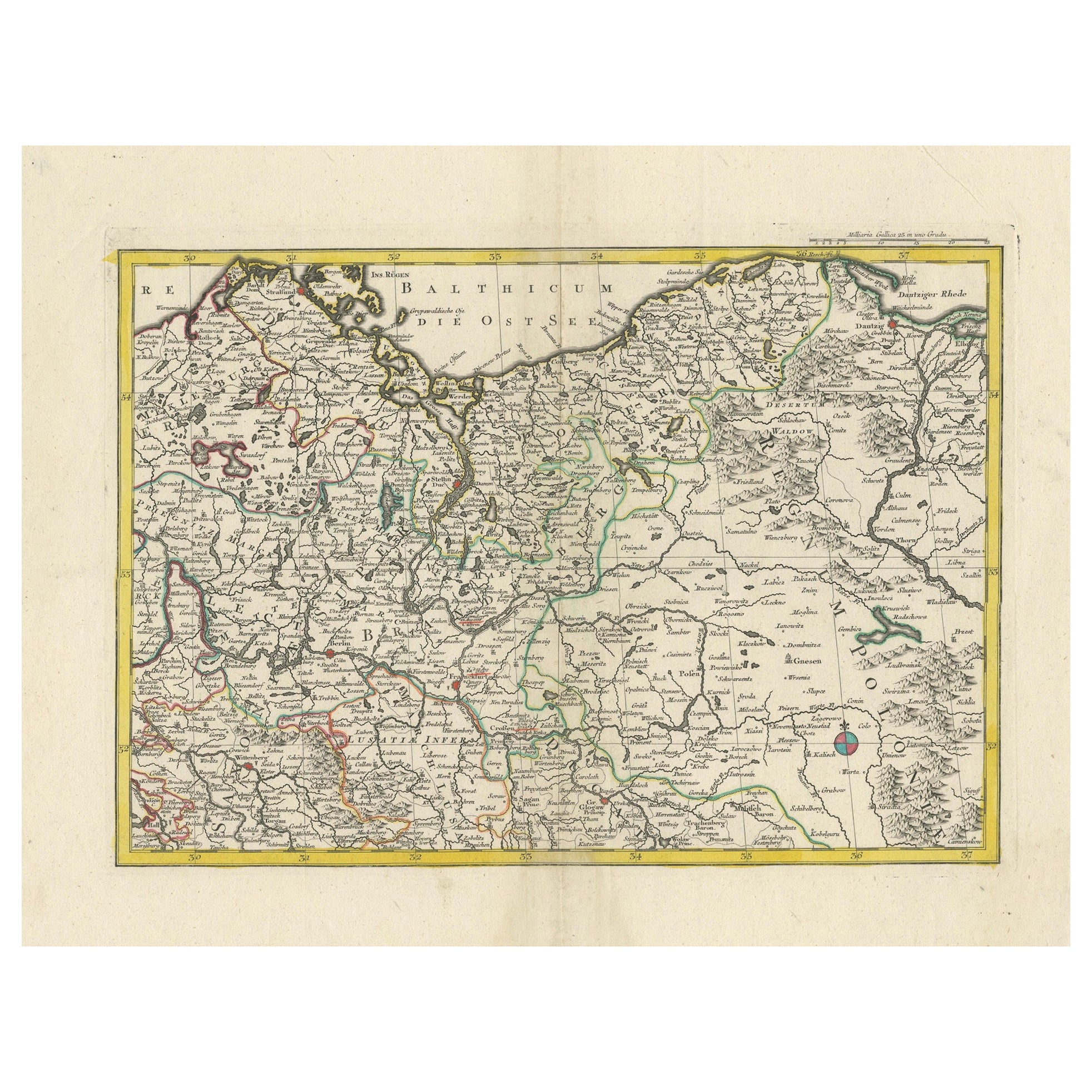
A Detailed Mid-18th Century German Map of North-Central Europe
Located in Langweer, NL
This is an antique, hand-colored engraved map of north-central Europe (centered on the region of Brandenburg, Pomerania, and portions of what is now northern Poland) that was produce...
Category
Antique 1730s Maps
Materials
Paper
Antique Map of the Upper and Lower Rhine by Cary '1811'
By John Cary
Located in Langweer, NL
Antique map titled 'A New Map of the Circles of the Upper and Lower Rhine'. Antique map covering an area from Westphalia and Lower Saxony in the north to France and Swabia in the south.
Category
Antique Early 19th Century Maps
Materials
Paper

$239 Sale Price
20% Off
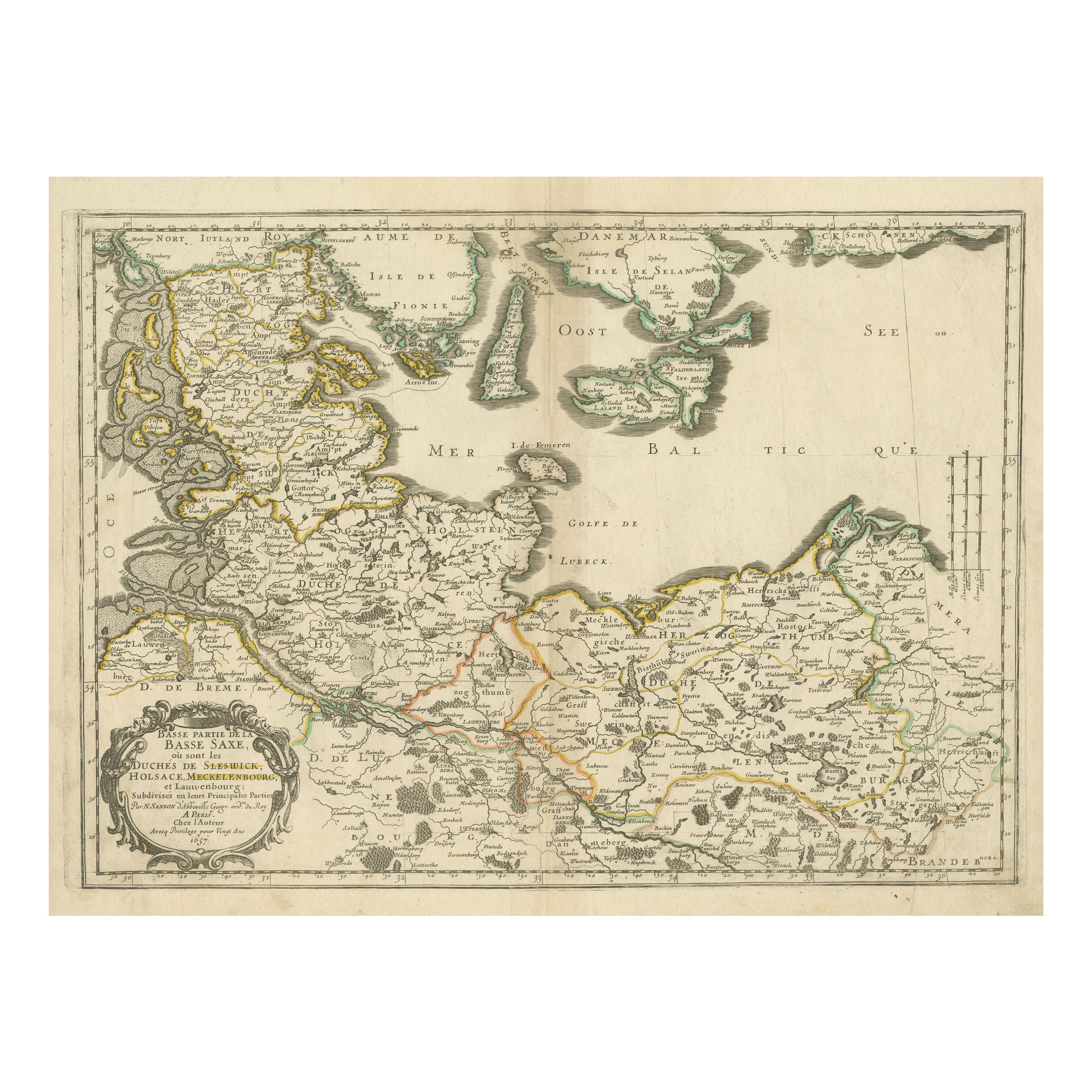
Antique Map of Northern Germany, Including Schleswig-Holstein and Hamburg
Located in Langweer, NL
Antique map titled 'Basse Partie de la Basse Saxe ou sont les Duchés de Sleswick, Holsace, Meckelenbourg et Lauvenbourg (..)'. Original old map of northern Germany, including Schlesw...
Category
Antique Mid-17th Century Maps
Materials
Paper
$517 Sale Price
20% Off
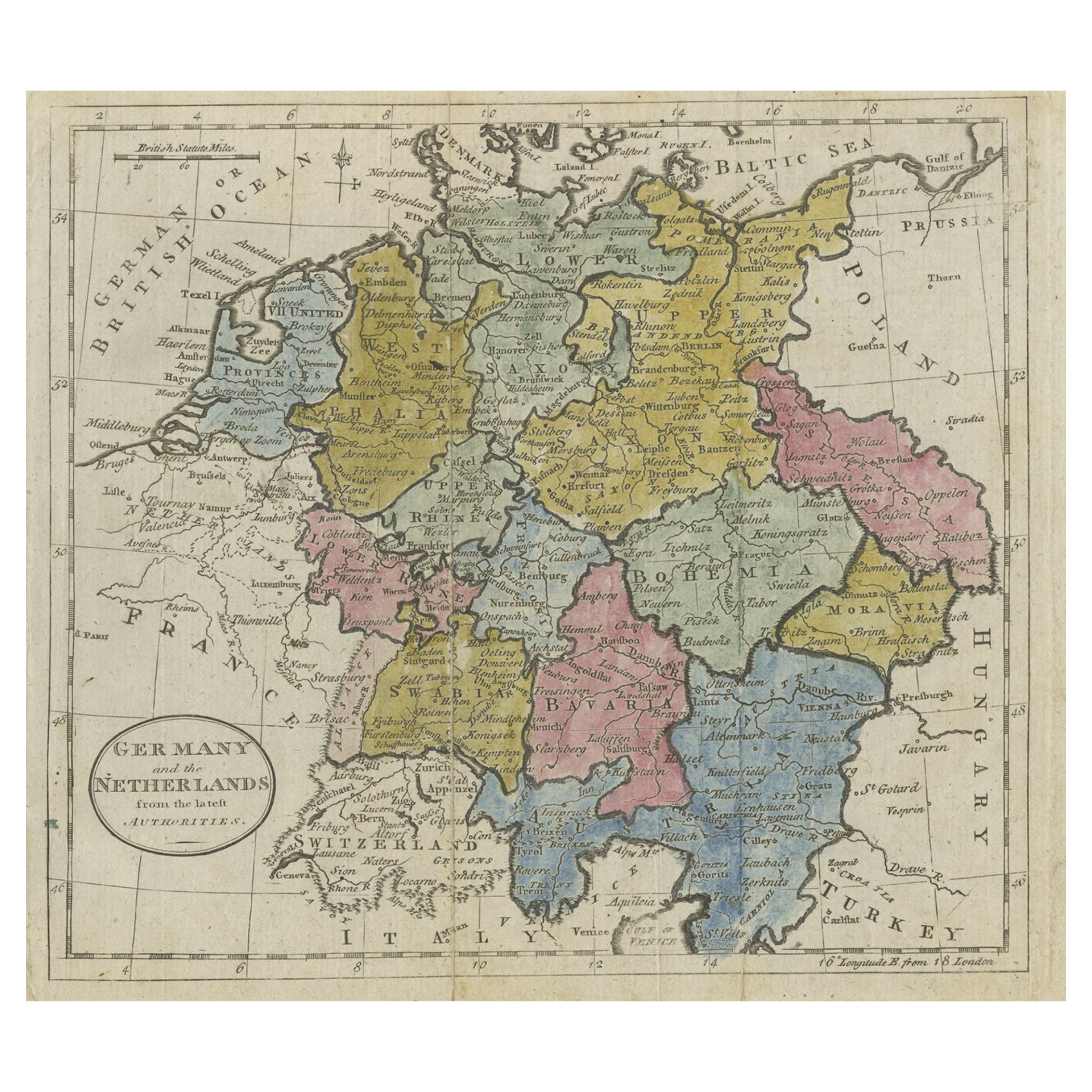
Antique Map of Germany, the Netherlands, Bohemia, Bavaria and Switzerland, 1785
Located in Langweer, NL
Antique map titled 'Germany and the Netherlands from the latest authorities'. Depicts Germany, the Netherlands and the surrounding region including Bohemia, Bavaria, and Switzerland....
Category
Antique 18th Century Maps
Materials
Paper
$134 Sale Price
20% Off
You May Also Like
18th Century Hand-Colored Homann Map of Germany, Including Frankfurt and Berlin
By Johann Baptist Homann
Located in Alamo, CA
An 18th century hand-colored map entitled "Tabula Marchionatus Brandenburgici et Ducatus Pomeraniae quae sunt Pars Septentrionalis Circuli Saxoniae Superioris" by Johann Baptist Homa...
Category
Antique Early 18th Century German Maps
Materials
Paper

1853 Map of "Russia in Europe Including Poland" Ric.r016
Located in Norton, MA
Description
Russia in Europe incl. Poland by J Wyld c.1853
Hand coloured steel engraving
Dimension: Paper: 25 cm W x 33 cm H ; Sight: 22 cm W x 28 cm H
Condition: Good ...
Category
Antique 19th Century Unknown Maps
Materials
Paper

Prussia, Poland, N. Germany, Etc: A Hand-colored 17th Century Map by Janssonius
By Johannes Janssonius
Located in Alamo, CA
This is an attractive hand-colored copperplate engraved 17th century map of Prussia entitled "Prussia Accurate Descripta a Gasparo Henneberg Erlichensi", published in Amsterdam by Joannes Janssonius in 1664. This very detailed map from the golden age of Dutch cartography includes present-day Poland, Latvia, Lithuania, Estonia and portions of Germany. This highly detailed map is embellished by three ornate pink, red, mint green and gold...
Category
Antique Mid-17th Century Dutch Maps
Materials
Paper

German Empire, Northern Part. Century Atlas antique vintage map
Located in Melbourne, Victoria
'The Century Atlas. German Empire, Northern Part.'
Original antique map, 1903.
Central fold as issued. Map name and number printed on the reverse corne...
Category
Early 20th Century Victorian More Prints
Materials
Lithograph

17th Century Hand-Colored Map of a Region in West Germany by Janssonius
By Johannes Janssonius
Located in Alamo, CA
This attractive highly detailed 17th century original hand-colored map is entitled "Archiepiscopatus Maghdeburgensis et Anhaltinus Ducatus cum terris adjacentibus". It was published ...
Category
Antique Mid-17th Century Dutch Maps
Materials
Paper

1790 Thomas Stackhouse Map, Entitled "Russia in Europe, " , Ric.a004
Located in Norton, MA
1790 Thomas Stackhouse map, entitled
"Russia in Europe"
Ric.a004
Stackhouse, Thomas
Russia in Europe [map]
London: T. Stackhouse, 1783. Map. Matted hand-colored copper engraving. Image size: 14.5 x 15.25 inches. Mat size: 22.75 x 23.75 inches. A beautiful example of this map of Eastern Europe...
Category
Antique 17th Century Unknown Maps
Materials
Paper

More Ways To Browse
Elios Chair
Plata Lappas
Red Retro Dining Set
Antique Bouquet
Antique Silver Glasses Case
Carlo Scarpa 1934 Chairs
Christofle Marly
1900 Antique Chairs
Glass Table Italian Round
Mid Century Colonial
Alvar Aalto Poster
Geometric Metal Table
Post Modern High Chairs
United Nations
Vintage Vine Rug
Cancel An Order
Antique Framing Square
Silver Metal Chair