Items Similar to 1830 Map of Northern England and Durham, Cumberland, Westmorland, Northumberland

Want more images or videos?
Request additional images or videos from the seller
1 of 7
1830 Map of Northern England and Durham, Cumberland, Westmorland, Northumberland
$401.69
£301.09
€340
CA$551.86
A$616.10
CHF 322.83
MX$7,541.65
NOK 4,099.90
SEK 3,865.68
DKK 2,588.20
Shipping
Retrieving quote...The 1stDibs Promise:
Authenticity Guarantee,
Money-Back Guarantee,
24-Hour Cancellation
About the Item
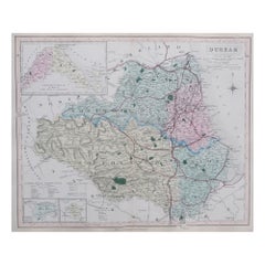
Title: Antique 1830 Map of Northern England with Durham, Cumberland, Westmorland, and Northumberland
Description: This 1830 German-language map, titled Britisches Reich – A. Kon: England, focuses on northern England and highlights the counties of Durham, Westmorland, Cumberland, and Northumberland. The map was published in Leipzig by Georg Joachim Goschen as part of the Atlas von Europa nebst den Kolonien, designed for businesspeople, newspaper readers, and owners of the Conversations-Lexicon. It was lithographed by O. Hermann and edited by W. E. A. von Schlieben.
Each county is outlined in hand-applied color, distinguishing political boundaries. Major cities and towns such as Newcastle, Durham, Carlisle, and Lancaster are marked, along with significant geographical features, including 'the coastline along the North Sea (Deutsche Meer) and the Irish Sea (Irische Meer)'. The Scottish border is clearly defined at the top of the map.
This map exemplifies early 19th-century European cartographic precision, reflecting the influence of German publishers in producing detailed maps of the British Isles.
Condition Report:
Paper Quality: 19th-century laid paper with natural toning.
Engraving: Crisp lithographic print with sharp details.
Coloring: Original hand-applied outline coloring, well-preserved.
Margins: Wide margins with light foxing and minor discoloration.
Overall Condition: Very good, with no significant tears or defects.
Framing Tips:
Matting: Use an acid-free off-white mat to highlight the map’s aged character.
Glass: Museum-grade UV-protective glass to prevent fading.
Frame Style: A simple dark wood or gilt frame complements its antique style.
Mounting: Archival backing for long-term preservation.
This is a fine example of German-published 19th-century cartography, ideal for collectors of British and European maps.
- Dimensions:Height: 12.88 in (32.7 cm)Width: 10.44 in (26.5 cm)Depth: 0.01 in (0.2 mm)
- Materials and Techniques:Paper,Engraved
- Period:
- Date of Manufacture:1830
- Condition:Overall Condition: Very good, with no significant tears or defects. Wide margins with some foxing spots and minor discoloration.
- Seller Location:Langweer, NL
- Reference Number:Seller: BG-13711-71stDibs: LU3054343840562
About the Seller
5.0
Recognized Seller
These prestigious sellers are industry leaders and represent the highest echelon for item quality and design.
Platinum Seller
Premium sellers with a 4.7+ rating and 24-hour response times
Established in 2009
1stDibs seller since 2017
2,511 sales on 1stDibs
Typical response time: <1 hour
- ShippingRetrieving quote...Shipping from: Langweer, Netherlands
- Return Policy
Authenticity Guarantee
In the unlikely event there’s an issue with an item’s authenticity, contact us within 1 year for a full refund. DetailsMoney-Back Guarantee
If your item is not as described, is damaged in transit, or does not arrive, contact us within 7 days for a full refund. Details24-Hour Cancellation
You have a 24-hour grace period in which to reconsider your purchase, with no questions asked.Vetted Professional Sellers
Our world-class sellers must adhere to strict standards for service and quality, maintaining the integrity of our listings.Price-Match Guarantee
If you find that a seller listed the same item for a lower price elsewhere, we’ll match it.Trusted Global Delivery
Our best-in-class carrier network provides specialized shipping options worldwide, including custom delivery.More From This Seller
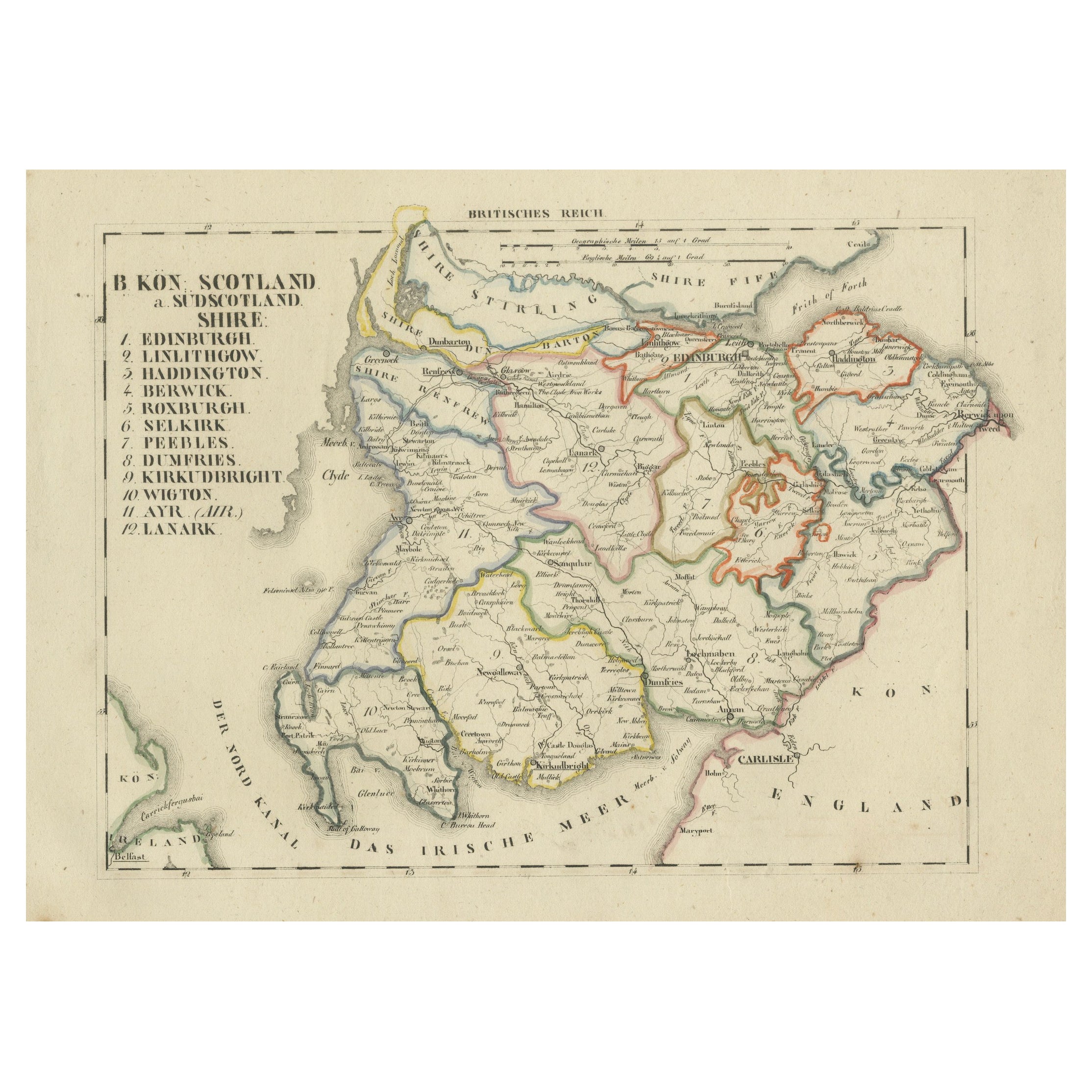
View AllAntique 1830 Map of Southern Scotland with Edinburgh, Berwick, Ayr, and Dumfries
Located in Langweer, NL
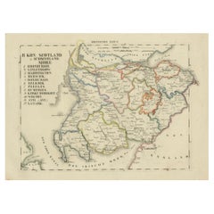
Title: Antique 1830 Map of Southern Scotland with Edinburgh, Berwick, Ayr, and Dumfries
Description: This 1830 German-language map, titled Britisches Reich – B. Kon Scotland, fo...
Category
Antique 1830s Maps
Materials
Paper
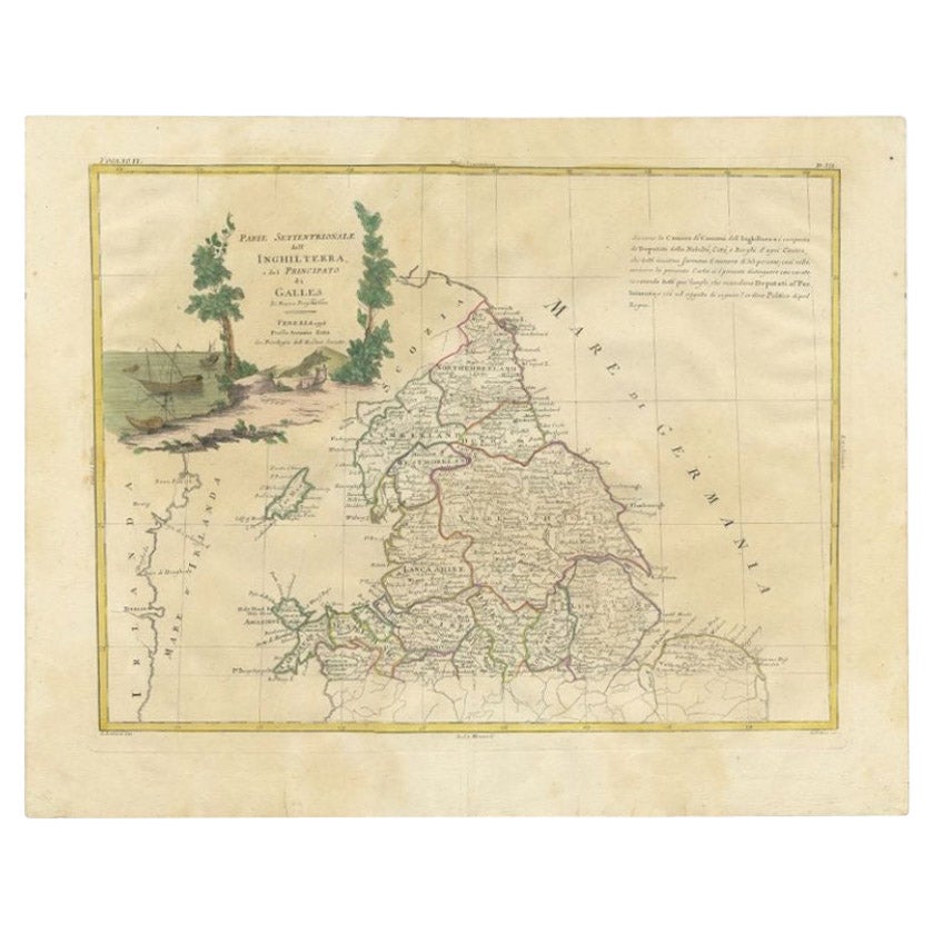
Antique Map of Northern England and Wales by Zatta, 1784
Located in Langweer, NL
Antique map titled 'Parte Settentrionale dell' Inghilterra e del Principato di Galles'. Engraved map of the northern part of England and Wales, with title cartouche. Shows political and administrative divisions, towns, villages, forests, mountains and rivers. This print originates from 'Atlante Novissimo, illustrato ed accresciuto sulle osservazioni, e scoperte fatte dai piu' celebri e piu' recenti geografi' by A. Zatta. Artists and Engravers: Antonio Zatta (active 1757-1797) was the most prominent Italian map...
Category
Antique 18th Century Maps
Materials
Paper

$201 Sale Price
20% Off
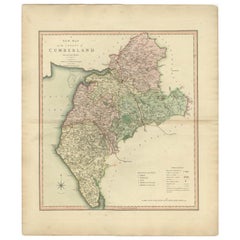
Large Antique County Map of Northumberland, England
Located in Langweer, NL
Antique map titled 'A Map of Northumberland from the best Authorities'. Original old county map of Northumberland, England. Engraved by John Cary. Originates from 'New British Atlas'...
Category
Antique Early 19th Century Maps
Materials
Paper

$226 Sale Price
20% Off
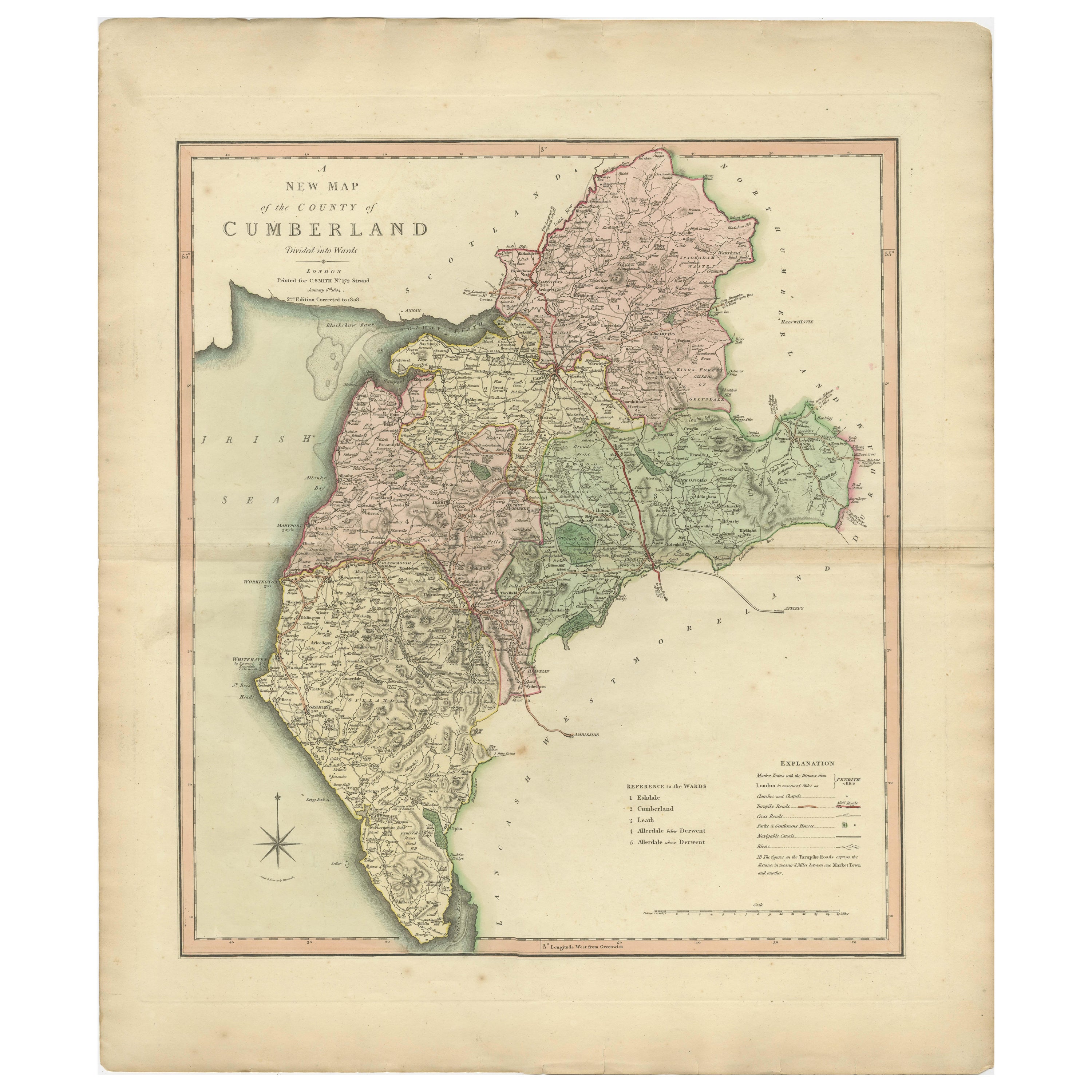
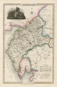
Antique Decorative and Detailed County Map of Cumberland, England, 1804
Located in Langweer, NL
Antique county map of Cumberland first published c.1800. Villages, towns, and cities illustrated include Carlisle, Penrith, Copeland Forest, and Wigt...
Category
Antique Early 1800s Maps
Materials
Paper
$307 Sale Price
20% Off
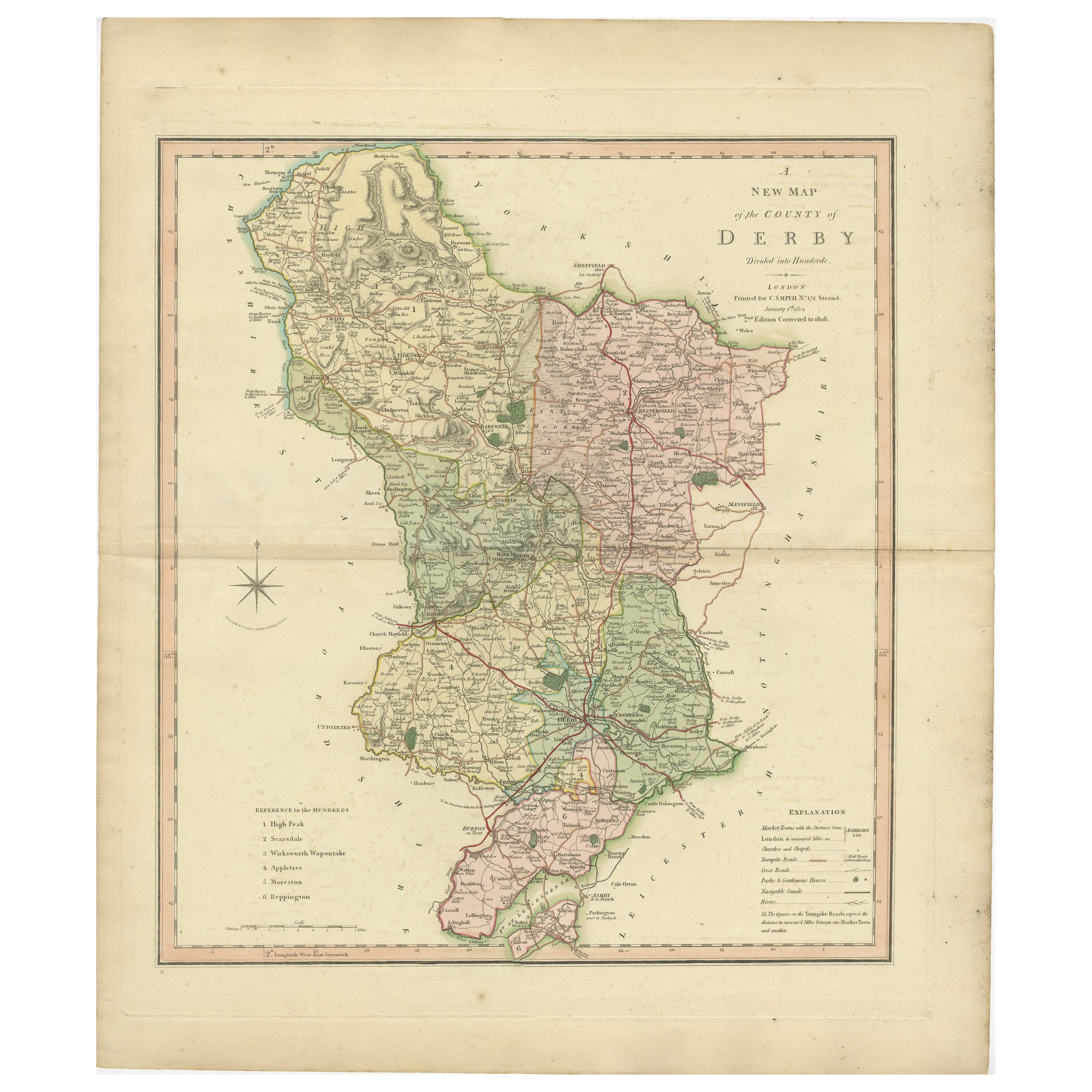
Antique County Map of Derbyshire, England, 1804
Located in Langweer, NL
Antique county map of Derbyshire first published, circa 1800. Villages, towns, and cities illustrated include Chesterfield, Wirksworth, Derby, and ...
Category
Antique Early 1800s Maps
Materials
Paper

$307 Sale Price
20% Off
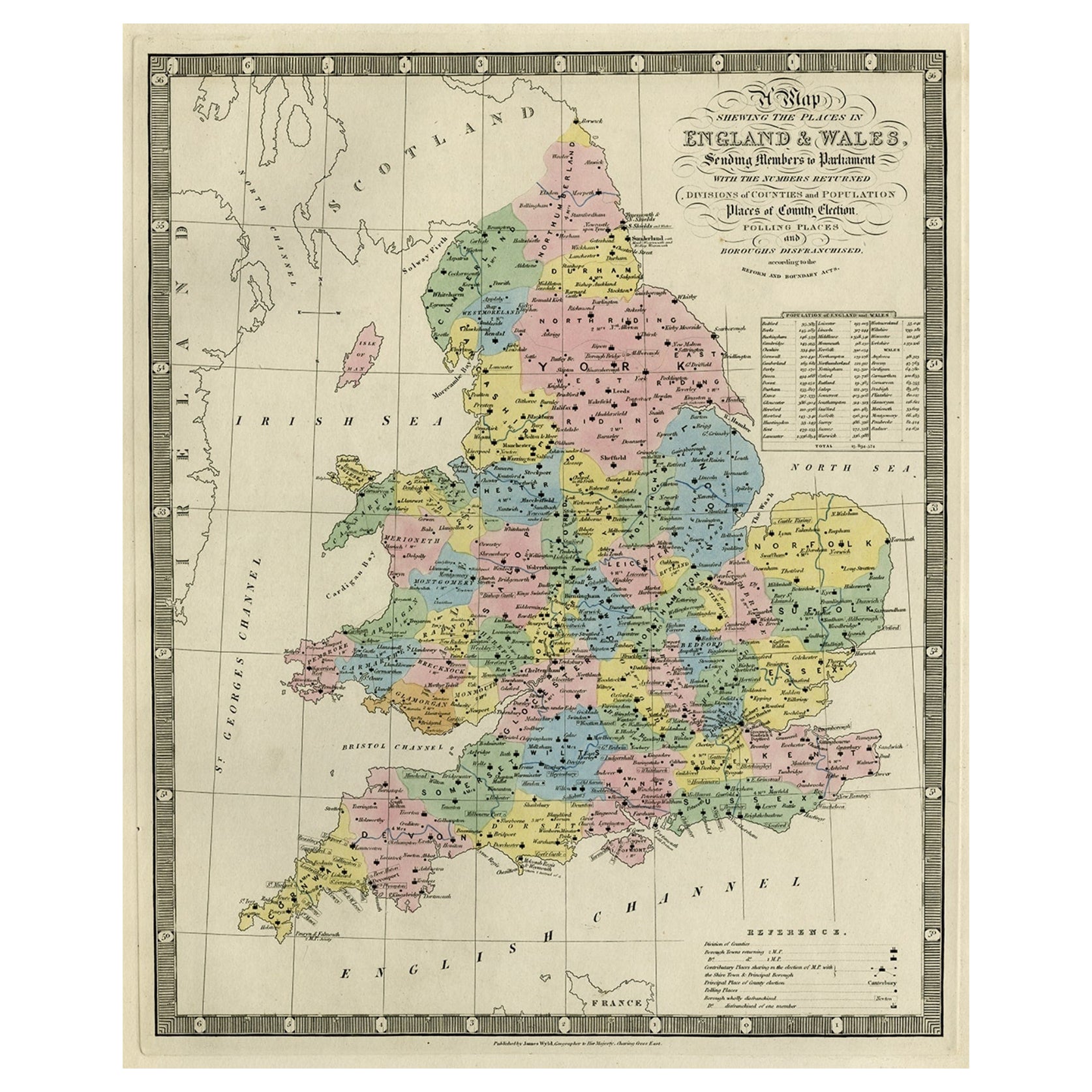
Colourful Antique Map of England and Wales Divided in Counties, 1854
Located in Langweer, NL
Antique map titled 'A Map Shewing the Places in England & Wales Sending Members to Parliament with the numbers returned, divisions of counties and population, places of county electi...
Category
Antique 19th Century Maps
Materials
Paper

$614 Sale Price
20% Off
You May Also Like
Cumberland, English County Antique map, 1847
By Isaac Slater
Located in Melbourne, Victoria
Steel-engraved map with original outline colouring by Isaac Slater. A detailed engraved map of the English county with title, scale, and key. Decorated with an uncoloured engraved vi...
Category
19th Century Naturalistic Landscape Prints
Materials
Engraving
Original Antique English County Map, Derbyshire, J & C Walker, 1851
Located in St Annes, Lancashire
Great map of Derbyshire
Original colour
By J & C Walker
Published by Longman, Rees, Orme, Brown & Co. 1851
Unframed.
Category
Antique 1850s English Other Maps
Materials
Paper

Original Antique English County Map, Nottinghamshire, J & C Walker, 1851
Located in St Annes, Lancashire
Great map of Nottinghamshire
Original colour
By J & C Walker
Published by Longman, Rees, Orme, Brown & Co. 1851
Unframed.
Category
Antique 1850s English Other Maps
Materials
Paper

Original Antique English County Map, Durham, J & C Walker, 1851
Located in St Annes, Lancashire
Great map of Durham
Original colour
By J & C Walker
Published by Longman, Rees, Orme, Brown & Co. 1851
Unframed.
Category
Antique 1850s English Other Maps
Materials
Paper
Original Antique English County Map, Rutland, J & C Walker, 1851
Located in St Annes, Lancashire
Great map of Rutland
Original colour
By J & C Walker
Published by Longman, Rees, Orme, Brown & Co. 1851
Unframed.
Category
Antique 1850s English Other Maps
Materials
Paper

Original Antique English County Map, Herefordshire, J & C Walker, 1851
Located in St Annes, Lancashire
Great map of Herefordshire
Original colour
By J & C Walker
Published by Longman, Rees, Orme, Brown & Co. 1851
Unframed.
Category
Antique 1850s English Other Maps
Materials
Paper

More Ways To Browse
Antique Furniture Northern Ireland
Antique Furniture Northumberland
Vintage Scandanavian Chairs
19th Century Red Glass
Antique French Console Table Tables
Silver Bowl Large
Antique French Silk
Down Couch
Used Lighter Art
Blue Edge Glass
Mahogany 1950s Furniture
Solid Mahogany Table
Dessert Glasses
Geometric Glass Table
Mid Century Pin
6x10 Rug
Studded Furniture
Styles Of Antique Desks