Items Similar to 1849 Hand-Colored Map of Fort Smith to Santa Fe Route, Detailing Trails & Camps

Want more images or videos?
Request additional images or videos from the seller
1 of 12
1849 Hand-Colored Map of Fort Smith to Santa Fe Route, Detailing Trails & Camps
$402.58
$503.2220% Off
£299.69
£374.6120% Off
€336
€42020% Off
CA$551.43
CA$689.2920% Off
A$613.31
A$766.6420% Off
CHF 320.25
CHF 400.3120% Off
MX$7,463.32
MX$9,329.1520% Off
NOK 4,090.09
NOK 5,112.6220% Off
SEK 3,835.79
SEK 4,794.7320% Off
DKK 2,557.85
DKK 3,197.3120% Off
Shipping
Retrieving quote...The 1stDibs Promise:
Authenticity Guarantee,
Money-Back Guarantee,
24-Hour Cancellation
About the Item
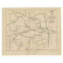
Map Title: Map, No. 3, Showing Continuation of Details of Fort Smith and Santa Fe Route, from Mounds Near the 100½ Degree of W. Longitude to Tucumcari Creek
Cartographer: James H. Simpson (Lt. Col.)
Subject: Oklahoma & Texas, Canadian River
Date: 1849 (dated)
Publication: Sen. Ex. Doc. 12, 31st Congress, 1st Session
Color: Hand-colored
Map Size: 20.1 x 12.4 inches (51.1 x 31.5 cm)
This map is the third sheet of a four-part map that outlines Lt. Simpson’s route through Oklahoma and the Texas panhandle, following the Canadian River. It offers precise details on emigrant routes, trails, and campsites, with special attention to the area south of the Canadian River, which is noted as inhabited by Comanche and Kioway Indians. The scale of the map is 10 miles per inch, and it includes a table of distances from Fort Smith.
The route along the Canadian River, depicted in this 1849 map, traverses areas that are now part of Oklahoma and the Texas Panhandle. In the mid-19th century, this region was quite remote, largely undeveloped, and sparsely populated by Euro-American settlers. It was primarily inhabited by Indigenous groups like the Comanche and Kiowa, who were known for their dominance of the Southern Plains. These tribes were skilled horsemen and had a long history of resisting encroachment on their lands, which made this route potentially dangerous for emigrants and military expeditions.
Travelers on this trail faced numerous risks, including the threat of attack by Native American groups, particularly during periods of tension or conflict. The harsh landscape itself presented challenges: the dry, open plains of the Llano Estacado ("Staked Plain") had little water and few landmarks, making navigation difficult and survival precarious. Additionally, emigrants risked encountering severe weather, including storms and extreme heat, as well as wildlife hazards.
Today, much of this area is part of modern Oklahoma and Texas, with places like Amarillo, Texas, and parts of the Oklahoma Panhandle covering the region once crossed by Simpson’s route. The Llano Estacado still exists as a vast plateau, and the Canadian River continues to run through portions of these states, though the area is far more settled and developed than it was in the 19th century. Towns like Tucumcari, New Mexico, which is mentioned in the map, still exist as small communities today.
As for the Indigenous tribes mentioned in the map—Comanche and Kiowa—both were eventually forced to leave their traditional lands due to U.S. military campaigns and government policies. By the late 19th century, after enduring the Texas-Indian Wars and other conflicts, the Comanche were relocated to reservations in Oklahoma, specifically to the area around Fort Sill. The Kiowa also faced similar pressures and were moved to reservations in western Oklahoma, where they share lands with the Comanche and Apache. The forced relocation, part of the broader pattern of Indian Removal, drastically altered the lives of these tribes, curtailing their nomadic ways and confining them to smaller territories.
- Dimensions:Height: 12.41 in (31.5 cm)Width: 20.12 in (51.1 cm)Depth: 0 in (0.02 mm)
- Materials and Techniques:
- Period:
- Date of Manufacture:1849
- Condition:Good Condition. Issued folding, now flat, with light scattered foxing and a few tiny separations along the folds.
- Seller Location:Langweer, NL
- Reference Number:Seller: BG-138661stDibs: LU3054341866992
About the Seller
5.0
Recognized Seller
These prestigious sellers are industry leaders and represent the highest echelon for item quality and design.
Platinum Seller
Premium sellers with a 4.7+ rating and 24-hour response times
Established in 2009
1stDibs seller since 2017
2,508 sales on 1stDibs
Typical response time: <1 hour
- ShippingRetrieving quote...Shipping from: Langweer, Netherlands
- Return Policy
Authenticity Guarantee
In the unlikely event there’s an issue with an item’s authenticity, contact us within 1 year for a full refund. DetailsMoney-Back Guarantee
If your item is not as described, is damaged in transit, or does not arrive, contact us within 7 days for a full refund. Details24-Hour Cancellation
You have a 24-hour grace period in which to reconsider your purchase, with no questions asked.Vetted Professional Sellers
Our world-class sellers must adhere to strict standards for service and quality, maintaining the integrity of our listings.Price-Match Guarantee
If you find that a seller listed the same item for a lower price elsewhere, we’ll match it.Trusted Global Delivery
Our best-in-class carrier network provides specialized shipping options worldwide, including custom delivery.More From This Seller
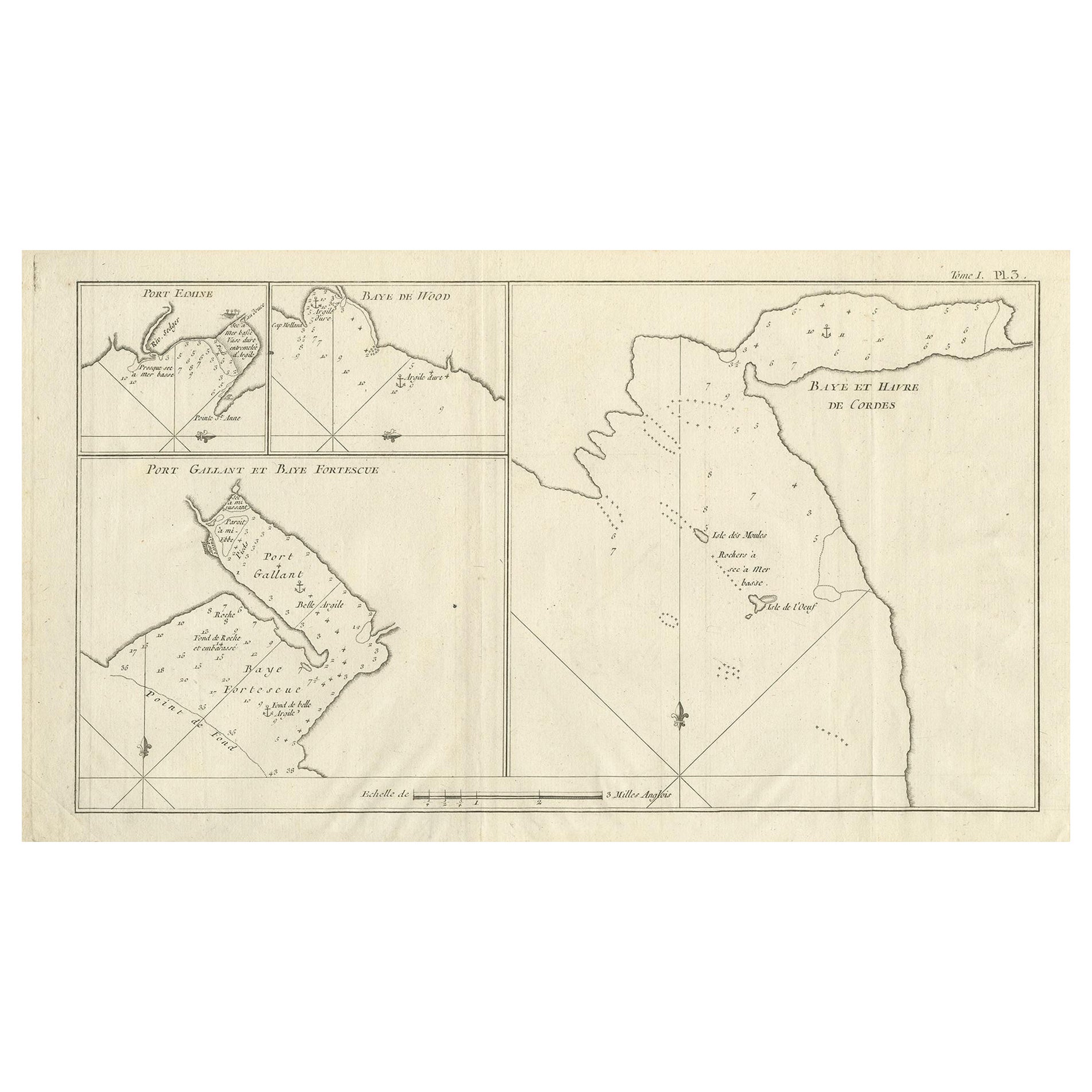
View AllAntique Map of Cordes Bay, Port Famine, Woods Bay and Surroundings
Located in Langweer, NL
Antique map titled 'Baye et Havre de Cordes (..)'. Four maps on the one sheet of; Cordes Bay, Port Famine, Woods Bay, Port Gallant, Fortescue Bay, Chile based on the voyage of John B...
Category
Antique Late 18th Century Maps
Materials
Paper
$316 Sale Price
20% Off
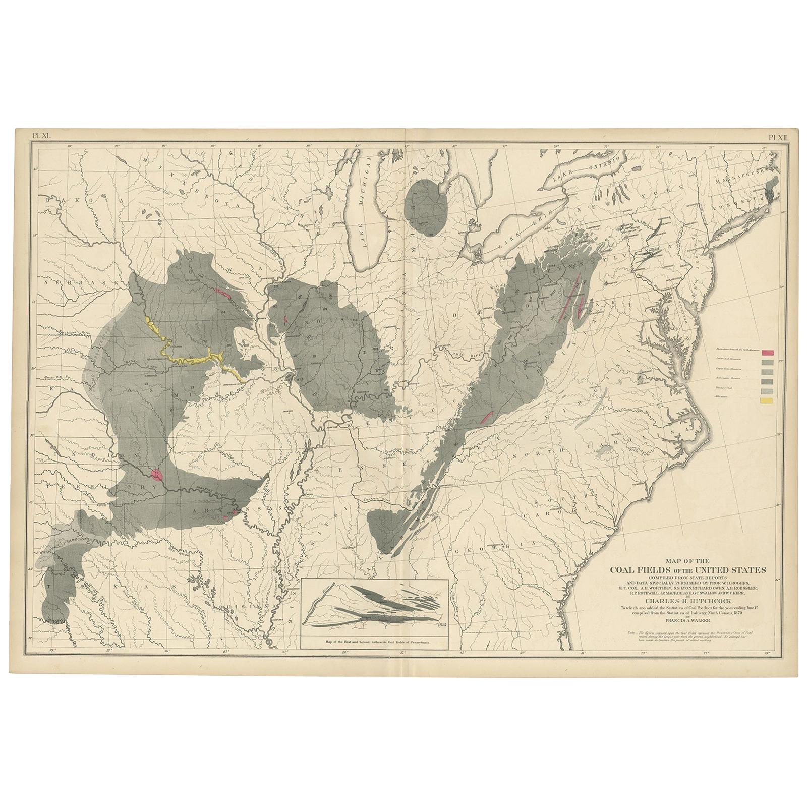
Antique Map of the Coal Fields of the United States by Walker '1874'
Located in Langweer, NL
Antique map titled 'Map of the coal fields of the United States, compiled from state reports and data specially furnished by Prof. W.B. Rogers, E.T. Cox, A.H. Worthen, S.S. Lyon, Ric...
Category
Antique Late 19th Century Maps
Materials
Paper
$718 Sale Price
20% Off
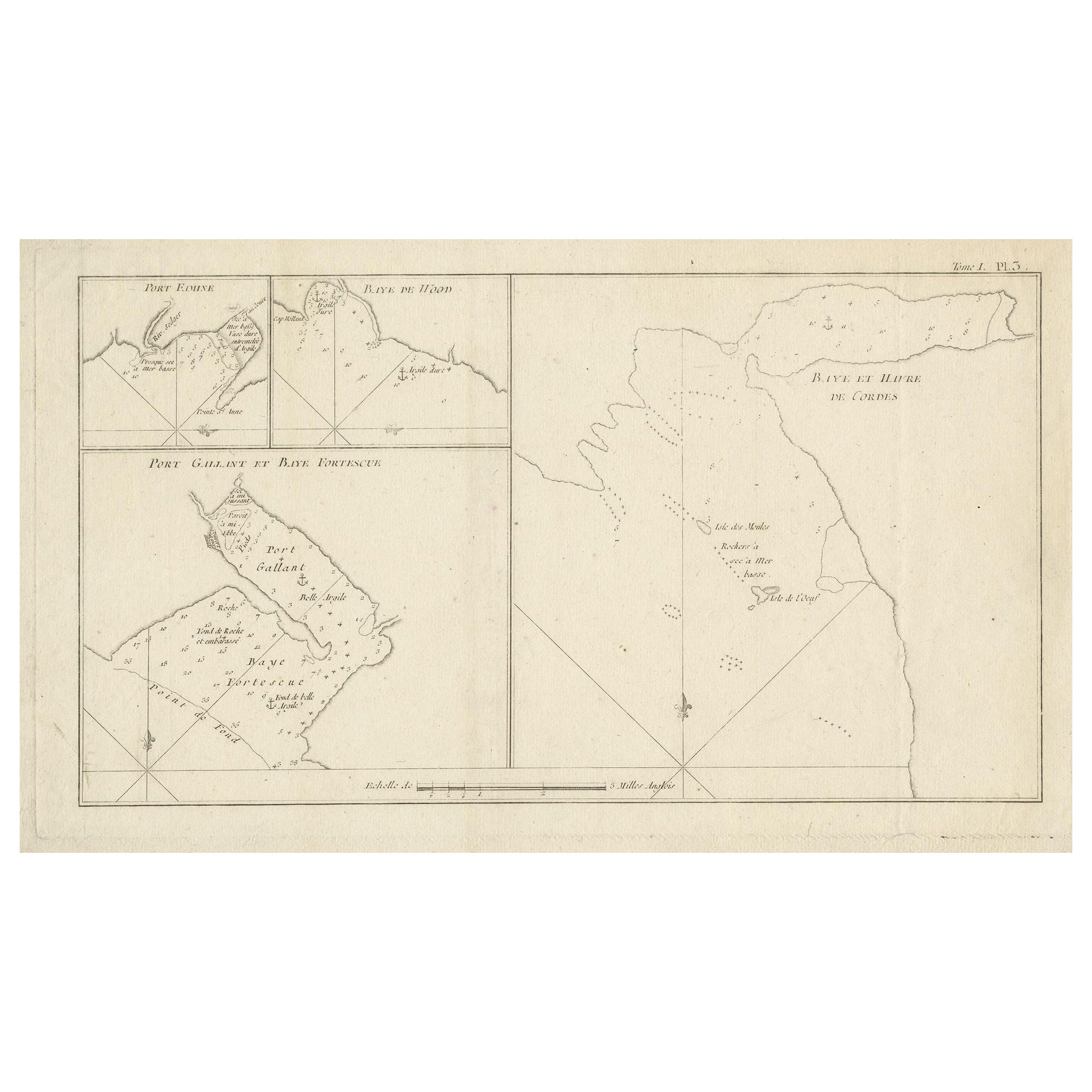
Antique Map of Cordes Bay and Surroundings
Located in Langweer, NL
Antique map titled 'Baye et Havre de Cordes (..)'. Four maps on the one sheet of; Cordes Bay, Port Famine, Woods Pay, Port Gallant, Fortescue Bay, Chile based on the voyage of John B...
Category
Antique Late 18th Century Maps
Materials
Paper
$249 Sale Price
20% Off
Old Map of Cook's Discovery and Charting of the East Coast of Australia, 1803
Located in Langweer, NL
Antique map titled 'Kaart van Nieuw Zuid Wales of de Oostlyke Kust van Nieuw Holland ontdekt en onderzogt door den Luitenant J. Cook met het Schip de Endeavour in het Jaar 1770'.
...
Category
Antique Early 1800s Maps
Materials
Paper

$1,677 Sale Price
20% Off
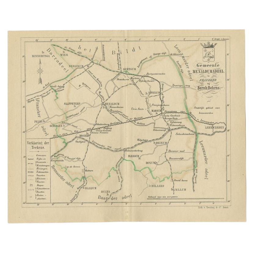
Antique Map of the Menaldumadeel Township by Behrns, 1861
Located in Langweer, NL
Antique map titled 'Gemeente Menaldumadeel'. Old map depicting the Menaldumadeel township including cities and villages like Berlikum, Wier, Menaldum, Dronrijp, Marsum, Engelum, Dein...
Category
Antique 19th Century Maps
Materials
Paper
$85 Sale Price
20% Off
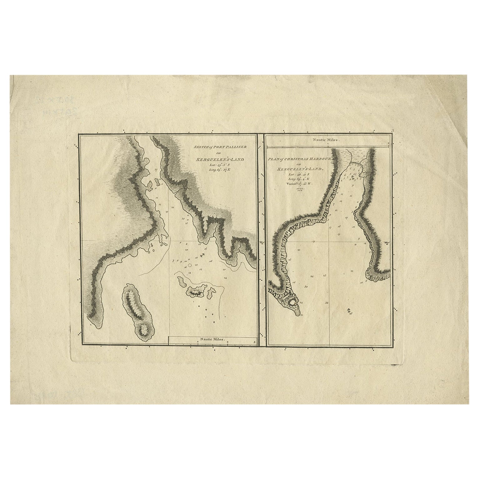
Antique Map of Port Pallisers & Kersmis by Cook, 1784
Located in Langweer, NL
Antique map Kerguelen titled 'Sketch of Port Palliser on Kerguelen's Land (..)'. Antique map of Port Pallisers & Kersmis, Kerguelen or Desolation Islands. Originates from an edition ...
Category
Antique 18th Century Maps
Materials
Paper
$210 Sale Price
20% Off
You May Also Like
1864 Map of North America, Antique Hand-Colored Map, by Adolphe Hippolyte Dufour
Located in Colorado Springs, CO
Offered is a map of North America entitled Amerique du Nord from 1864. This rare, separately published wall map was produced by Adolphe Hippolyte Dufour. This map includes vibrant an...
Category
Antique 1860s French Maps
Materials
Paper

Rare 18th C. Newport Map
Located in Sandwich, MA
Rare 18th C, Map titled "A plan of the town of Newport in the province of Rhode Island". Earliest printed plan of Newport, published for the use of the British just prior to their o...
Category
Antique 1770s American Maps
Materials
Paper

$19,500 / item
Wychmere Harbor Allens Harbor Map Circa 1890
Located in Norwell, MA
Map of Harwich Mass showing Wychmere Harbor, Doane's Creek, Allens Harbor, Herring River, Pleasant Lake, Grassy Pond, Paddocks Pond, Hinkleys Pond, etc., This is an original period m...
Category
Antique 1890s North American Maps
Materials
Paper
English Engraved Hand Colored Map of the North Eastern United States, circa 1817
Located in Charleston, SC
English copper engraved hand colored map of the North Eastern United States matted under glass in a gilt frame, Early 19th Century. Drawn and Engraved for Thomson's New General Atlas...
Category
Antique 1810s English George III Maps
Materials
Glass, Giltwood, Paint, Paper

Original Antique Map of the American State of Colorado, 1903
Located in St Annes, Lancashire
Antique map of Colorado
Published By A & C Black. 1903
Original colour
Good condition
Unframed.
Free shipping
Category
Antique Early 1900s English Maps
Materials
Paper

1839 Map of Karte Des "Russischen Reiches in Europa Und Asien" Ric.R0013
Located in Norton, MA
1839 map of Karte Des
"Russischen Reiches in Europa and Asien"
Ric.r013
Map of the European and Asian parts of Russian Empire. Karte der Russischen Reiches in Europa und Asien...
Category
Antique 19th Century Unknown Maps
Materials
Paper

More Ways To Browse
Santa Fe Furniture
Antique Furniture Oklahoma
Antique Table Plateau
19th Century Campaign Table
Antique Mexican Table
Coffee Tables Europe
Marble Top Dining Tables
Nordiska Argentina
Pink And Black Rug
Black Wooden Chair
Orrefors Embassy
Black Ebonized
Elios Chair
Panache Designs
Plata Lappas
Red Retro Dining Set
Antique Bouquet
Antique Silver Glasses Case