Items Similar to 1852 Map of Haut-Rhin: An Illustrated Gateway to Alsace's Viticultural Splendors

Want more images or videos?
Request additional images or videos from the seller
1 of 8
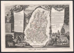
1852 Map of Haut-Rhin: An Illustrated Gateway to Alsace's Viticultural Splendors
$325.90
$407.3720% Off
£242.56
£303.2020% Off
€272
€34020% Off
CA$446.39
CA$557.9920% Off
A$496.49
A$620.6120% Off
CHF 259.25
CHF 324.0620% Off
MX$6,041.74
MX$7,552.1720% Off
NOK 3,311.03
NOK 4,138.7920% Off
SEK 3,105.16
SEK 3,881.4520% Off
DKK 2,070.64
DKK 2,588.3020% Off
Shipping
Retrieving quote...The 1stDibs Promise:
Authenticity Guarantee,
Money-Back Guarantee,
24-Hour Cancellation
About the Item
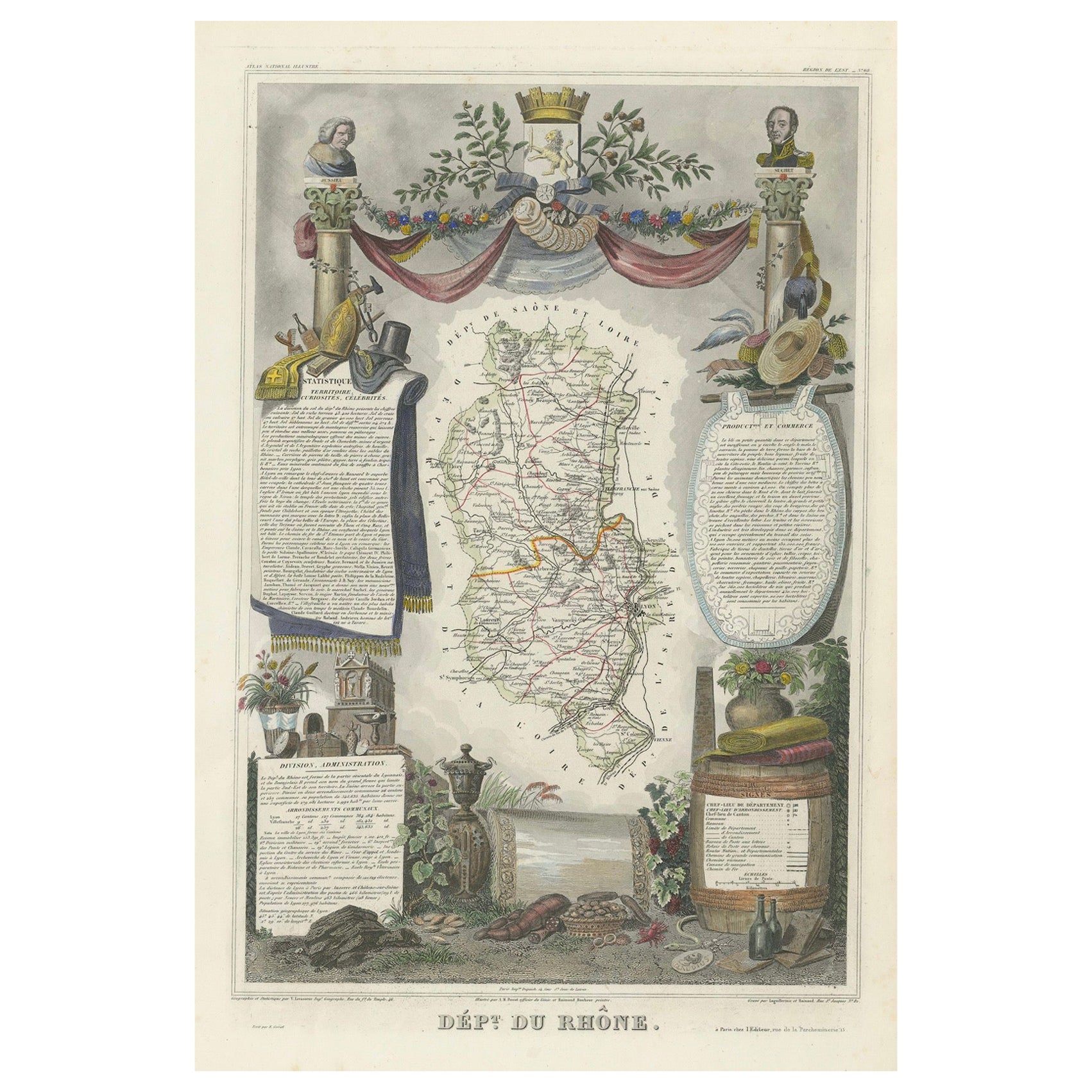
This original hand-colored map is from the "Atlas National Illustré," a work by Victor Levasseur, a French geographer and cartographer known for his richly illustrated maps.
The map is a steel engraving, which was a common and precise method for creating maps at the time. The inclusion of the publisher's name, A. Combette from Paris, and the addresses of the various contributors to the map's creation, like the engravers Laguillermie and Rainaud, adds to the historical context of the piece.
The margins of the map are adorned with detailed illustrations that serve as a visual encyclopedic reference to the region's geography, economy, and notable figures. The use of color along the boundaries makes the map not only a tool for navigation but also an educational resource, providing insights into the department's landscape, economy, and cultural significance.
The text included in the map's design provides statistical information, a map legend, and discussions about the land, local curiosities, notable personalities, products, and commerce, which would have been invaluable for education and reference at the time.
The 'Atlas National Illustré' is celebrated for its combination of cartographic detail and artistic embellishment, making it a valuable cultural artifact. It represents the height of decorative map-making in the 19th century, alongside the works of John Tallis and Archibald Fullarton.
This particular map is an illustrated map of the 'Département de Vaucluse,' located in the Provence-Alpes-Côte d'Azur region of southeastern France.
The title 'Dépt. de Vaucluse' is displayed at the top of the map. The map itself is surrounded by elaborate margin illustrations that likely represent the local heritage, economy, and cultural symbols of Vaucluse. These typically include images of local produce, historical figures, landscapes, traditional clothing, and the coat of arms.
Key places and features of the Vaucluse department that are historically significant and may be highlighted on the map include:
1. **Avignon**: Known for the Palais des Papes (Papal Palace), where several popes and antipopes lived during the 14th century, and its well-preserved medieval city center.
2. **Orange**: Famous for its Roman theatre and the Triumphal Arch, both of which are UNESCO World Heritage Sites.
3. **Mont Ventoux**: A prominent mountain in the region, known as the "Giant of Provence" and famed for its challenging stage in the Tour de France bicycle race.
4. **Fontaine-de-Vaucluse**: The source of the Sorgue river, a spring that is the largest in France and the fifth largest in the world.
5. **The Luberon**: A massif in central Vaucluse that is part of the Parc Naturel Régional du Luberon, known for its picturesque villages like Gordes and Roussillon.
6. **Carpentras**: This town is known for its historical sites and as the former capital of the Comtat Venaissin.
7. **The Côtes du Rhône wine region**: Vaucluse is home to famous vineyards, including Châteauneuf-du-Pape.
8. **The Ochre of Roussillon**: The ochre sands and cliffs around the village of Roussillon are a notable tourist attraction.
The map would have served both as a practical guide to the department and as an educational tool, showcasing the riches and points of interest of the Vaucluse area. The inclusion of local statistics and discussions about the land, curiosities, personages, products, and commerce in the text around the map would have provided 19th-century map readers with a comprehensive view of the region.
- Dimensions:Height: 14.18 in (36 cm)Width: 20.75 in (52.7 cm)Depth: 0 in (0.02 mm)
- Materials and Techniques:
- Period:
- Date of Manufacture:1852
- Condition:Good. Very decoartive and in excellent hand-coloring. A very light brown hue around the edges, adding to its patina. Study the images carefully.
- Seller Location:Langweer, NL
- Reference Number:Seller: BG-13703-51stDibs: LU3054338227872
About the Seller
5.0
Recognized Seller
These prestigious sellers are industry leaders and represent the highest echelon for item quality and design.
Platinum Seller
Premium sellers with a 4.7+ rating and 24-hour response times
Established in 2009
1stDibs seller since 2017
2,502 sales on 1stDibs
Typical response time: <1 hour
- ShippingRetrieving quote...Shipping from: Langweer, Netherlands
- Return Policy
Authenticity Guarantee
In the unlikely event there’s an issue with an item’s authenticity, contact us within 1 year for a full refund. DetailsMoney-Back Guarantee
If your item is not as described, is damaged in transit, or does not arrive, contact us within 7 days for a full refund. Details24-Hour Cancellation
You have a 24-hour grace period in which to reconsider your purchase, with no questions asked.Vetted Professional Sellers
Our world-class sellers must adhere to strict standards for service and quality, maintaining the integrity of our listings.Price-Match Guarantee
If you find that a seller listed the same item for a lower price elsewhere, we’ll match it.Trusted Global Delivery
Our best-in-class carrier network provides specialized shipping options worldwide, including custom delivery.More From This Seller
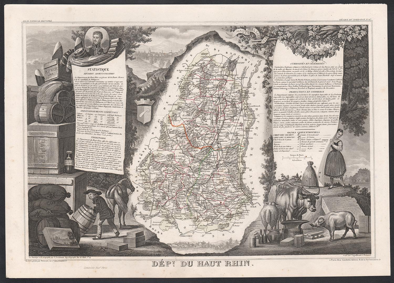
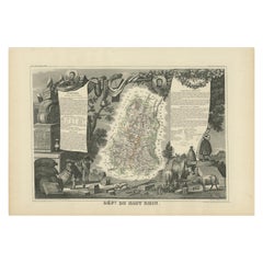
View AllAntique Map of Haut-Rhin, France by V. Levasseur, 1854
By Victor Levasseur
Located in Langweer, NL
Antique map titled 'Dépt. du Haut Rhin'. Map of the French department of Haut-Rhin, France. This mountainous area is part of the Alsace wine region and is known for its production of...
Category
Antique Mid-19th Century Maps
Materials
Paper
$143 Sale Price
20% Off
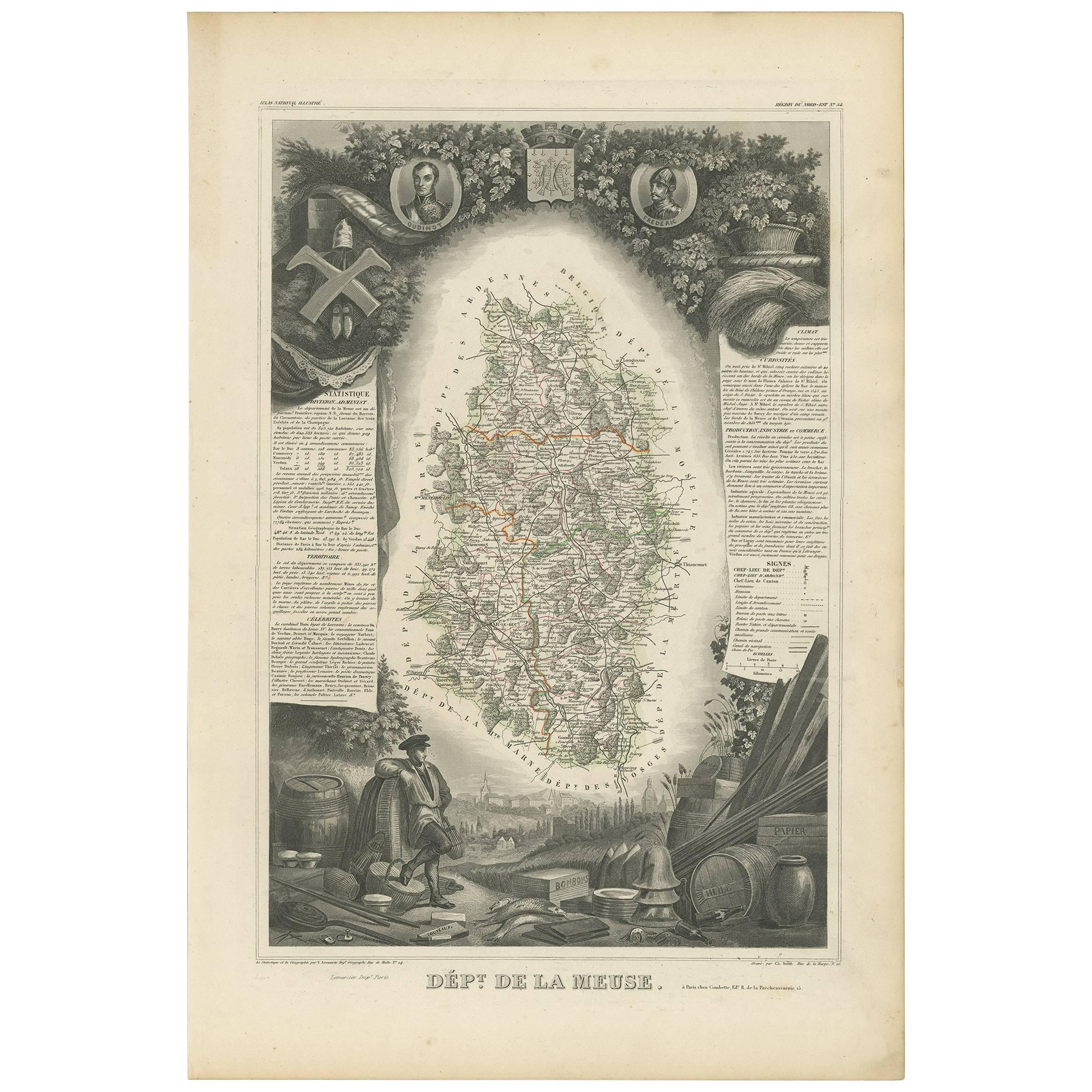
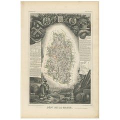
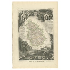
Antique Map of Meuse ‘France’ by V. Levasseur, 1854
Located in Langweer, NL
Antique map titled 'Dépt. de la Meuse'. Map of the French department of Meuse, France. This area part of the Lorraine or Alsace-Lorraine wine regions. It is also known for its produc...
Category
Antique Mid-19th Century Maps
Materials
Paper
$172 Sale Price
20% Off
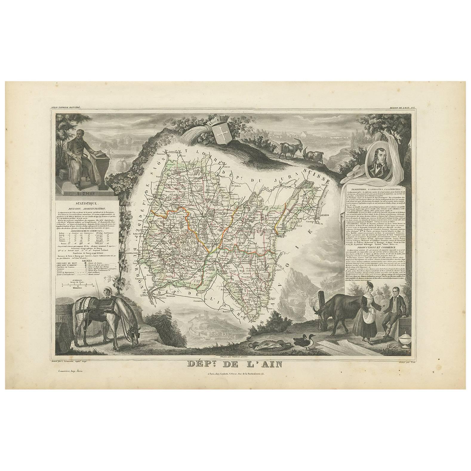
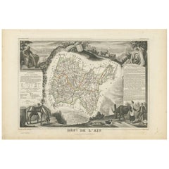
Antique Map of Ain ‘France’ by V. Levasseur, 1854
By Victor Levasseur
Located in Langweer, NL
Antique map titled 'Dépt. de l'Ain'. Map of the French department of l'Ain, France. This area of France is known for its Bugey wines, which are generally aromatic and white. It is al...
Category
Antique Mid-19th Century Maps
Materials
Paper
$172 Sale Price
20% Off
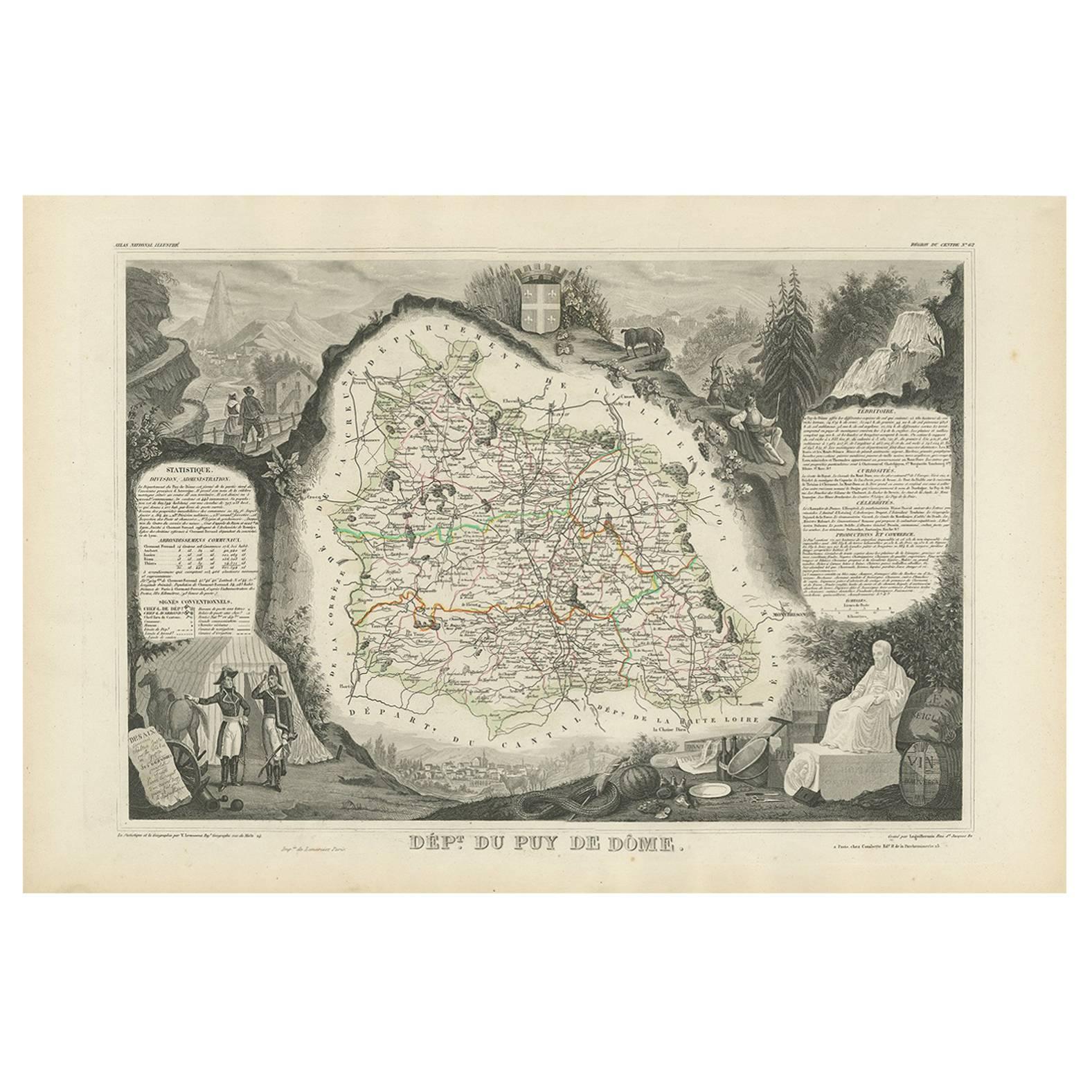
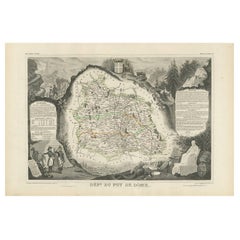
Antique Map of Puy de Dôme ‘France’ by V. Levasseur, 1854
By Victor Levasseur
Located in Langweer, NL
Antique map titled 'Dépt. du Puy de Dôme'. Map of the French department of Puy De Dome, France. This mountainous department includes Auvergne, one of the l...
Category
Antique Mid-19th Century Maps
Materials
Paper
$172 Sale Price
20% Off
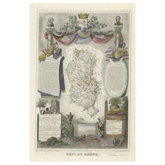
Map of Rhône: Culture and Commerce in Lyon's Silk and Wine Legacy, 1852
Located in Langweer, NL
This original hand-colored map is from the "Atlas National Illustré," a work by Victor Levasseur, a French geographer and cartographer known for his richly illustrated maps.
The map...
Category
Antique 1850s Maps
Materials
Paper
$325 Sale Price
20% Off
Antique Map of Haute Marne ‘France’ by V. Levasseur, 1854
Located in Langweer, NL
Antique map titled 'Dépt. de la Hte. Marne'. Map of the French department of Haute Marne, France. This department is part of the Champagne region, where the world-famous sparkling wi...
Category
Antique Mid-19th Century Maps
Materials
Paper
$172 Sale Price
20% Off
You May Also Like
Haut Rhin, France. Antique map of a French department, 1856
By Victor Levasseur
Located in Melbourne, Victoria
'Dept. du Bas Rhin', steel engraving with original outline hand-colouring., 1856, from Levasseur's Atlas National Illustre.
This mountainous area is part of the Alsace wine region ...
Category
19th Century Naturalistic Landscape Prints
Materials
Engraving
Bas Rhin, France. Antique map of a French department, 1856
By Victor Levasseur
Located in Melbourne, Victoria
'Dept. du Bas Rhin', steel engraving with original outline hand-colouring., 1856, from Levasseur's Atlas National Illustre.
Part of the Alsace wine region surrounding Strasbourg. T...
Category
19th Century Naturalistic Landscape Prints
Materials
Engraving

Jura, France. Antique map of a French department, 1856
By Victor Levasseur
Located in Melbourne, Victoria
'Dept. du Jura', steel engraving with original outline hand-colouring., 1856, from Levasseur's 'Atlas National Illustre'.
The Jura wines are very distinctive and unusual, such as V...
Category
19th Century Naturalistic Landscape Prints
Materials
Engraving

Fine French Antique 1856 Hand Watercolour Map of Dept Des Hautes Pyrenees
Located in West Sussex, Pulborough
We are delighted to offer for sale this stunning 1856 hand watercolour map of the Austrian Alps titled Dept Des Hautes Pyrenees taken from the Atlas Nat...
Category
Antique 1850s French Early Victorian Maps
Materials
Paper

Fine Antique 1856 Hand Watercolour Map of Dept Des Hautes Alpes by Levasseur's
Located in West Sussex, Pulborough
We are delighted to offer for sale this stunning 1856 hand watercolour map of the Austrian Alps titled Dept Des Hautes Alpes taken from the Atlas National...
Category
Antique 1850s French Early Victorian Maps
Materials
Paper

1839 Map of Karte Des "Russischen Reiches in Europa Und Asien" Ric.R0013
Located in Norton, MA
1839 map of Karte Des
"Russischen Reiches in Europa and Asien"
Ric.r013
Map of the European and Asian parts of Russian Empire. Karte der Russischen Reiches in Europa und Asien...
Category
Antique 19th Century Unknown Maps
Materials
Paper

More Ways To Browse
French Wine Map
Chateauneuf Du Pape
Early American Chairs
Hans Muller
Vintage Wood Table With Glass Top
19th Century Square Table
Antonio Bonet
Galle Chairs
Large Chinese Rug
1940s Vintage French Art Deco
20th Century Spanish Table
Antonio Bellini
Retro Fiberglass Furniture
Shipping Crate
Antique Oushak Carpets
Blue Coffee Tables
German Bauhaus Posters
1945 Chair Juhl