Items Similar to Fine Antique 1856 Hand Watercolour Map of Dept Des Hautes Alpes by Levasseur's

Want more images or videos?
Request additional images or videos from the seller
1 of 21
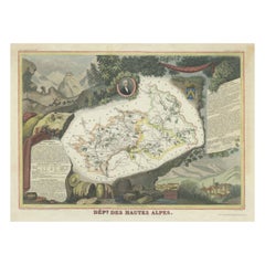
Fine Antique 1856 Hand Watercolour Map of Dept Des Hautes Alpes by Levasseur's
About the Item
We are delighted to offer for sale this stunning 1856 hand watercolour map of the Austrian Alps titled Dept Des Hautes Alpes taken from the Atlas National Illustre y Victor Levasseur
It was published in Paris by A. Combette in 1856. This hand-colored map is in good condition with minor age toning.
It contains a central map and has flanking text and elaborate borders of engravings from the region.
The condition is excellent so far as I can see, there will naturally be age related patina
Dimensions
Height:- 41.5cm
Width:- 54.5cm
Depth:- 2.5cm
Please note all measurements are taken at the widest point
This item is available for collection from our Pulborough warehouses
Condition
Please view the very detailed pictures as they form part of the description pertaining to the condition.
Please note vintage period and original items such as leather seating will always have natural patina in the form of creasing and wear, we recommend annual waxing to ensure no moisture is lost, also hand dyed leather is not recommended to sit in direct sunlight for prolonged periods of time as it will dry out and fade.
- Dimensions:Height: 16.34 in (41.5 cm)Width: 21.46 in (54.5 cm)Depth: 0.99 in (2.5 cm)
- Style:Early Victorian (Of the Period)
- Materials and Techniques:
- Place of Origin:
- Period:
- Date of Manufacture:1856
- Condition:Wear consistent with age and use. Minor fading.
- Seller Location:GB
- Reference Number:1stDibs: LU2823329915692
About the Seller
4.6
Gold Seller
These expertly vetted sellers are highly rated and consistently exceed customer expectations.
Established in 2012
1stDibs seller since 2017
1,722 sales on 1stDibs
Typical response time: 1 hour
- ShippingRetrieving quote...Ships From: United Kingdom
- Return PolicyA return for this item may be initiated within 14 days of delivery.
More From This SellerView All
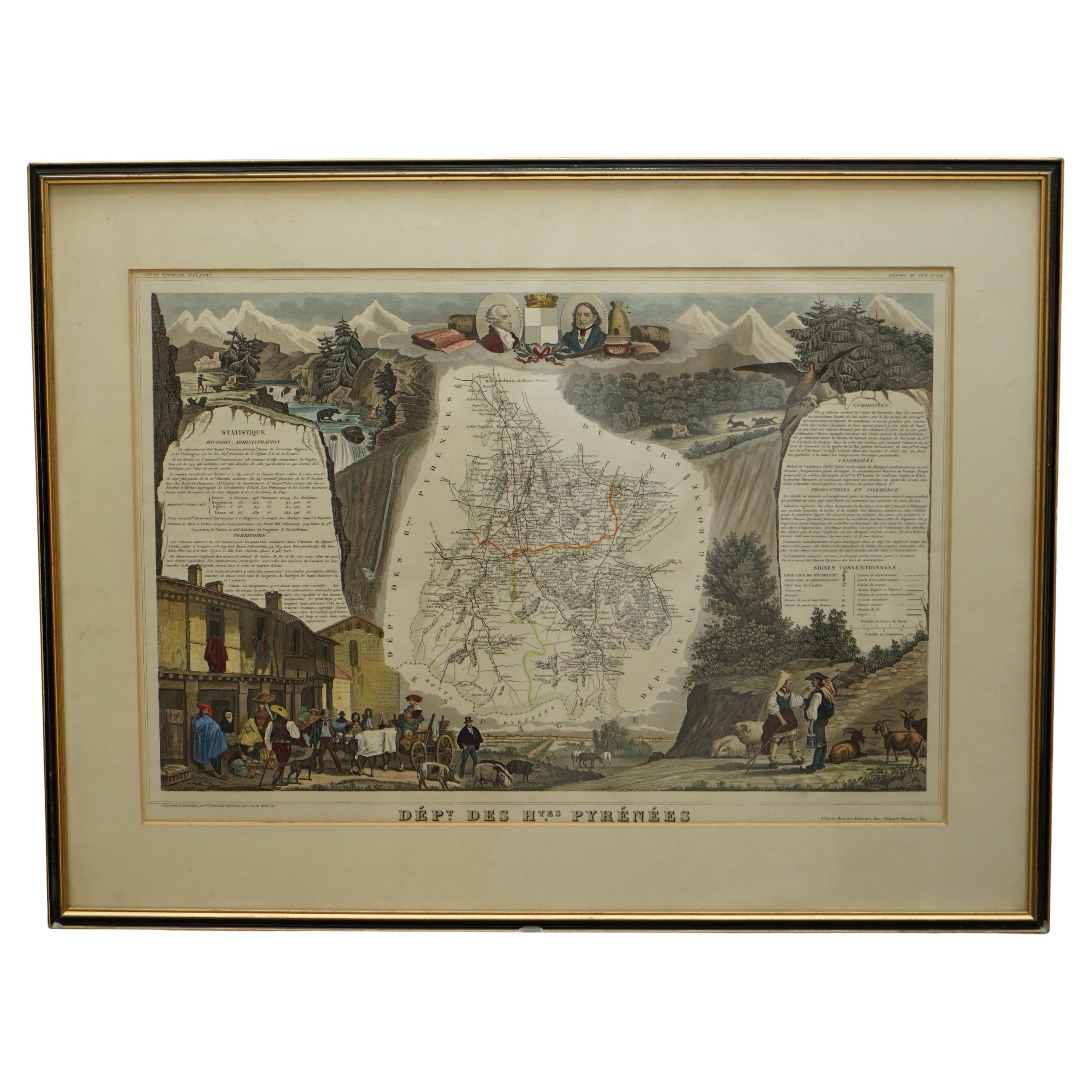
- Fine French Antique 1856 Hand Watercolour Map of Dept Des Hautes PyreneesLocated in GBWe are delighted to offer for sale this stunning 1856 hand watercolour map of the Austrian Alps titled Dept Des Hautes Pyrenees taken from the Atlas Nat...Category
Antique 1850s French Early Victorian Maps
MaterialsPaper
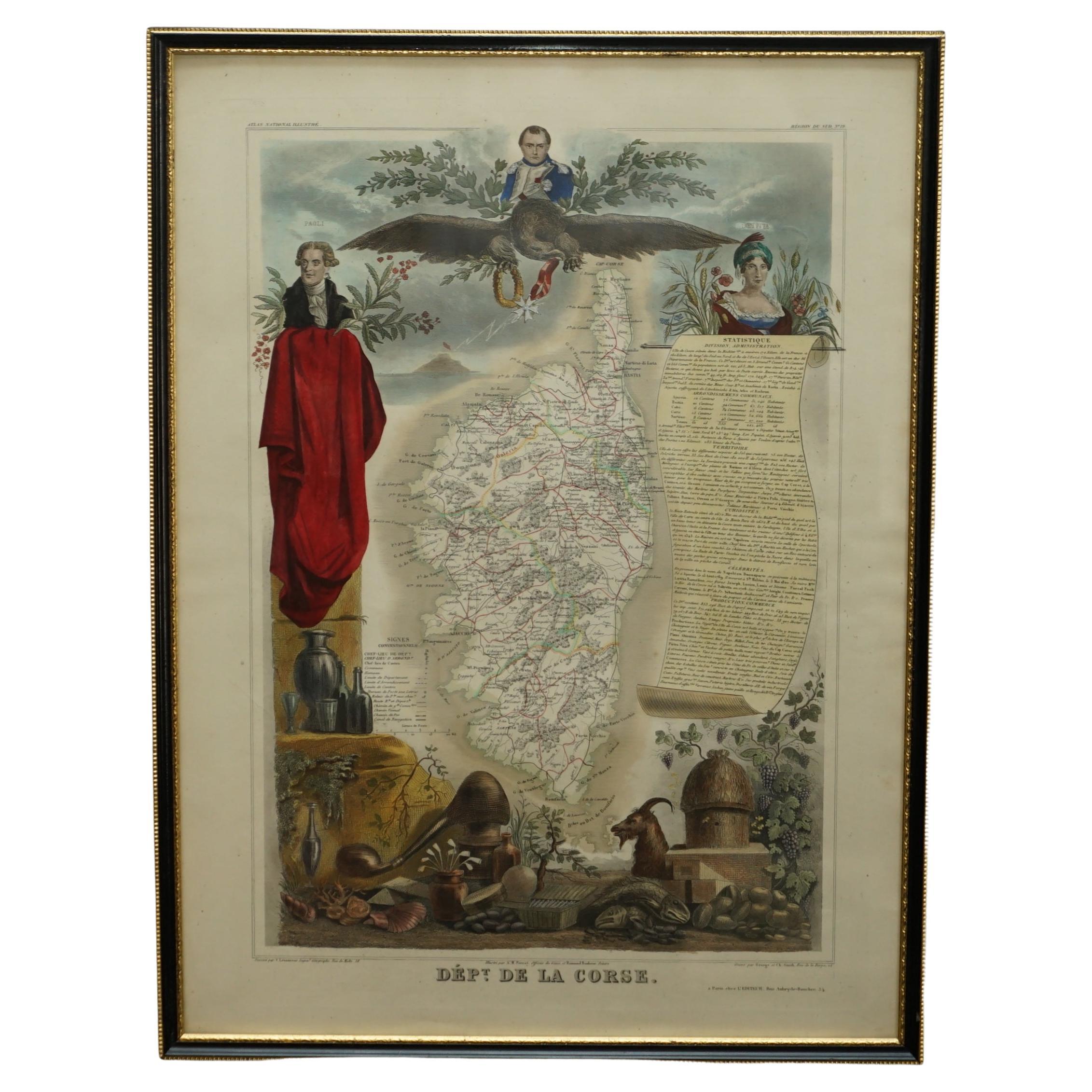
- Beautiful Colour French Antique 1856 Hand Watercolour Map of Dept Des La CorseLocated in GBWe are delighted to offer for sale this stunning 1856 hand watercolour map of the Austrian Alps titled Dept Des La Course taken from the Atlas National ...Category
Antique 1850s French Early Victorian Maps
MaterialsPaper
- London 1744 Published Watercolour Antique Map of East Africa by Eman BowenLocated in GBWe are delighted to offer for sale this New and Accurate Map of Nubia & Abissinia, together with all the Kingdoms Tributary Thereto, and bordering upon them published in 1744 by Emanuel Bowen This is a decorative antique engraved map of East Africa...Category
Antique 1740s English George III Maps
MaterialsPaper
- Staffordshire 1645 Hand Colored Antique Print Staffordiensis Comitatvs MapLocated in GBWe are delighted to offer for sale this lovely antique Atlas page map of Staffordshire printed in 1645 Amsterdam Staffordiensis Comitatvs Vulgo This o...Category
Antique Early 1800s English Georgian Maps
MaterialsPaper
- Greece 1660 Jan Jansson Watercolour Map Peloponesus Sive Morea I LaurenbergioLocated in GBWe are delighted to offer for sale this Jan Jansson Date: 1660 (published) Amsterdam map of Greece. This is an authentic antique map of Peloponnese or...Category
Antique 1660s Danish Dutch Colonial Maps
MaterialsCopper
- Double Sided Northamptonshire 1645 Hand Colored Antique Print Map Rare FindLocated in GBWe are delighted to this lovely antique Atlas page map of Northamptonshire printed in 1645 Amsterdam Staffordiensis Comitatvs Vulgo I have three of th...Category
Antique Early 1800s English Georgian Maps
MaterialsPaper


You May Also Like
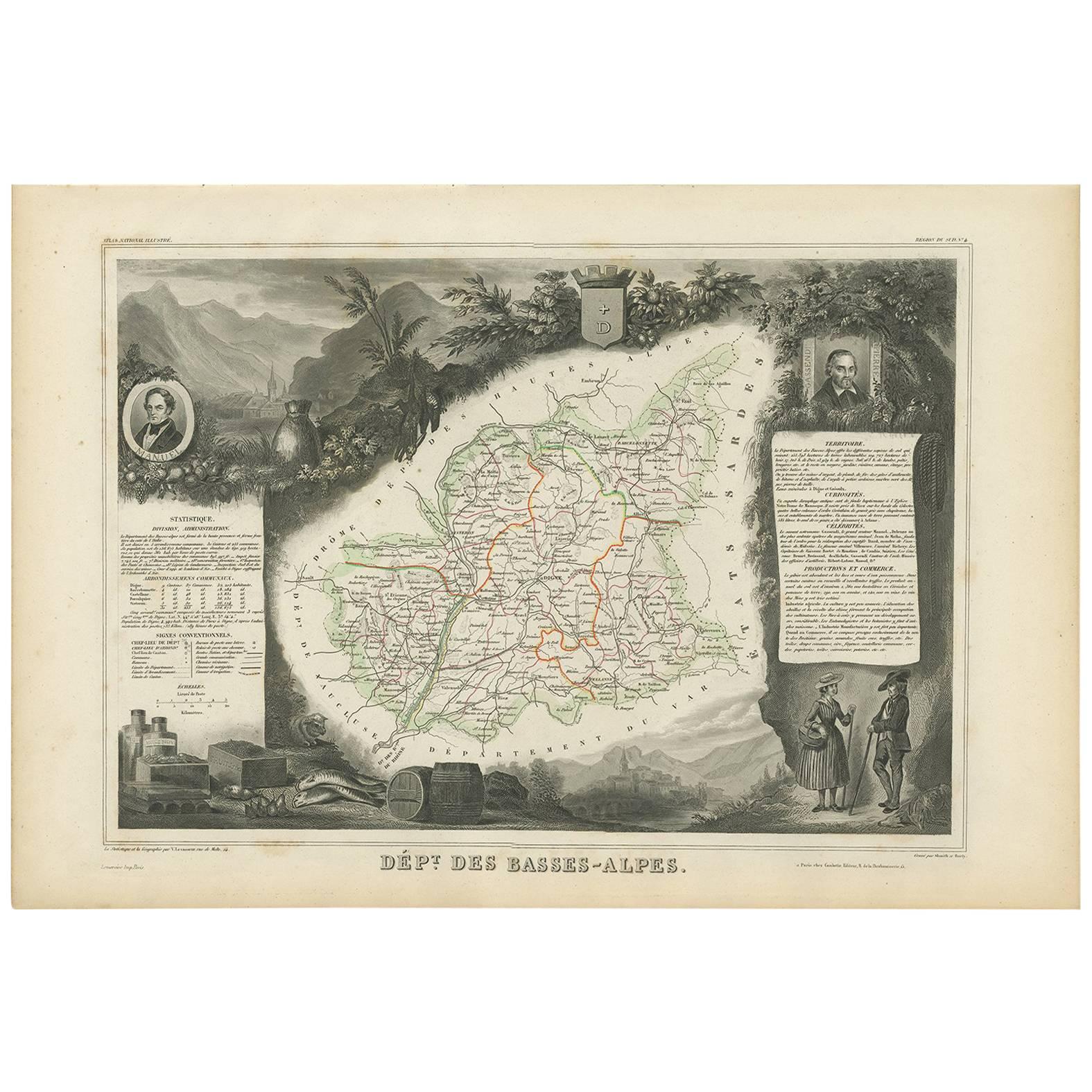
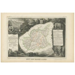
- Antique Map of Basses-Alpes ‘France’ by V. Levasseur, 1854By Victor LevasseurLocated in Langweer, NLAntique map titled 'Dépt. des Basses-Alpes'. Map of the French department of Basses-Alpes, France. The whole is surrounded by elaborate decorative engravings designed to illustrate b...Category
Antique Mid-19th Century Maps
MaterialsPaper
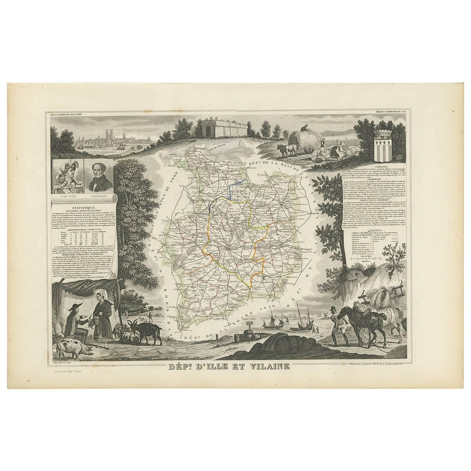
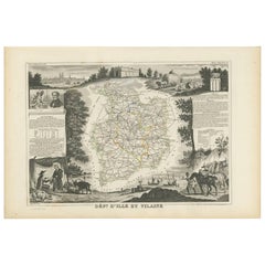
- Antique Map of Ille et Vilaine ‘France’ by V. Levasseur, 1854Located in Langweer, NLAntique map titled 'Dépt. d'Ille et Vilaine'. Map of the French department of Ille et Vilaine. France. Its coastal area is famous for its seafood, and especially its oysters. The reg...Category
Antique Mid-19th Century Maps
MaterialsPaper
- Hand Colored Antique Map of the department of Hautes Alpes, FranceBy Victor LevasseurLocated in Langweer, NLAntique map titled 'Dépt. des Hautes Alpes'. Map of the French department of Hautes Alpes, France. This area of France is known for its production of Cote...Category
Antique Mid-19th Century Maps
MaterialsPaper
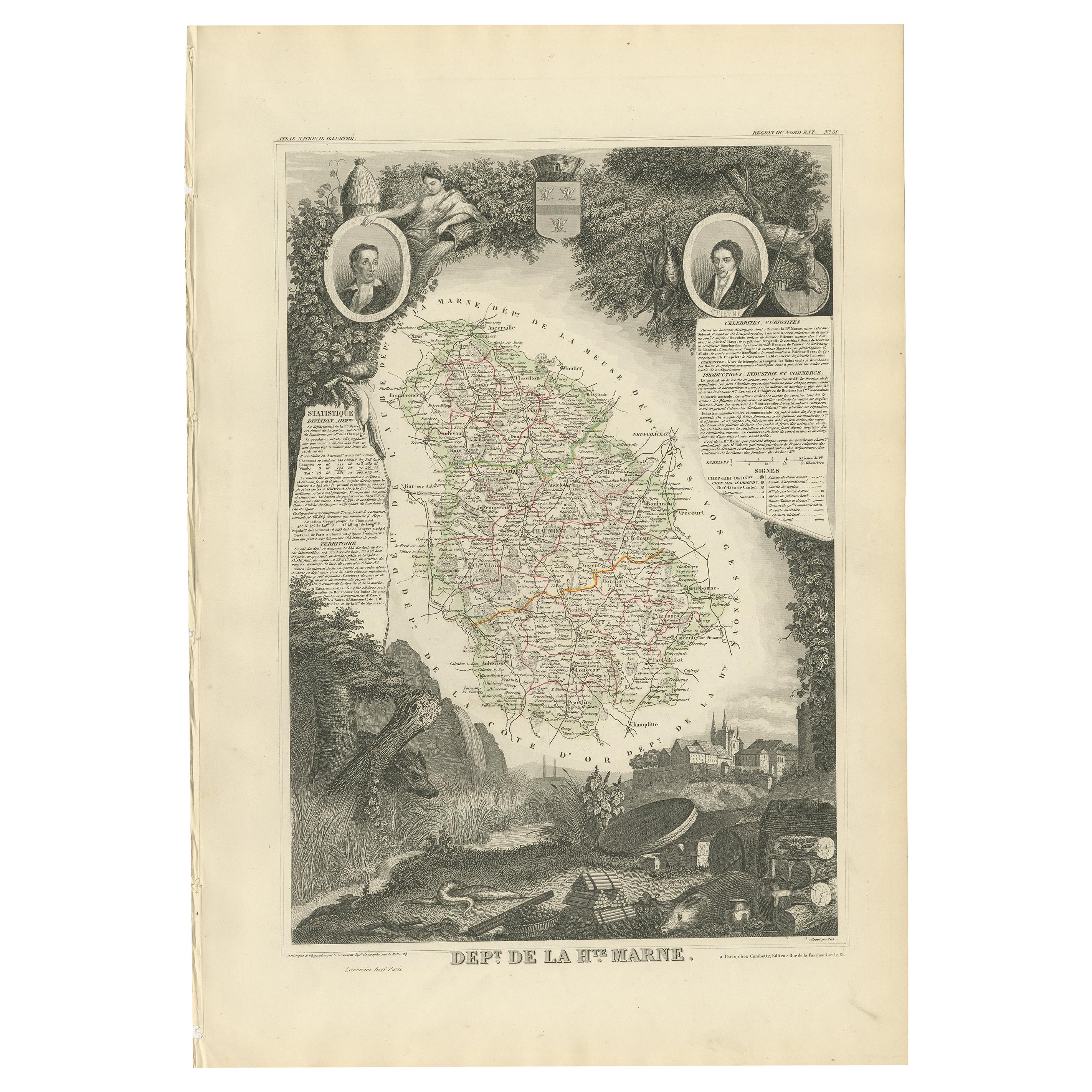
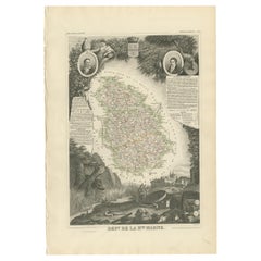
- Antique Map of Haute Marne ‘France’ by V. Levasseur, 1854Located in Langweer, NLAntique map titled 'Dépt. de la Hte. Marne'. Map of the French department of Haute Marne, France. This department is part of the Champagne region, where the world-famous sparkling wi...Category
Antique Mid-19th Century Maps
MaterialsPaper
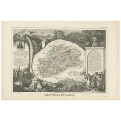
- Antique Map of Haute-Saone, France by V. Levasseur, 1854By Victor LevasseurLocated in Langweer, NLAntique map titled 'Dépt. de la Hte. Saône'. Map of the French department of Haute-Saone, France. Part of France's important Burgundy or Bourgogne Wine Region. This area is home to t...Category
Antique Mid-19th Century Maps
MaterialsPaper
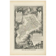
- Antique Map of Haute-Garonne ‘France’ by V. Levasseur, 1854Located in Langweer, NLAntique map titled 'Dépt. de la Hte. Garonne'. Map of the French department of Haute-Garonne, France. This area of France produces the delicious but lesser known Buzet wines, and ten...Category
Antique Mid-19th Century Maps
MaterialsPaper
Recently Viewed
View AllMore Ways To Browse
Vintage Antique And Collectible Items
Original Vintage Maps
Antique And Vintage Collectibles And Curiosities
Haute Antique
Antique French Watercolor
Antique French Watercolour
Austrian Alps
Austria Alps
Vintage French Map
Vintage Maps France
Austrian Vintage Antique
Alpes Furniture
Antique Map Of Austria
Vintage Map Paris
Vintage Map Of Paris France
Map Alps
Map Of Alps
Hand Painted Antique Map