Items Similar to London 1744 Published Watercolour Antique Map of East Africa by Eman Bowen

Want more images or videos?
Request additional images or videos from the seller
1 of 19
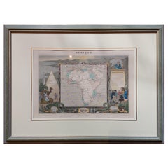
London 1744 Published Watercolour Antique Map of East Africa by Eman Bowen
$1,065.58
$1,331.9820% Off
£760
£95020% Off
€903
€1,128.7520% Off
CA$1,454.22
CA$1,817.7720% Off
A$1,619.40
A$2,024.2520% Off
CHF 842.81
CHF 1,053.5120% Off
MX$19,967
MX$24,958.7520% Off
NOK 10,733.81
NOK 13,417.2620% Off
SEK 10,088.74
SEK 12,610.9220% Off
DKK 6,737.51
DKK 8,421.8920% Off
Shipping
Retrieving quote...The 1stDibs Promise:
Authenticity Guarantee,
Money-Back Guarantee,
24-Hour Cancellation
About the Item
We are delighted to offer for sale this New and Accurate Map of Nubia & Abissinia, together with all the Kingdoms Tributary Thereto, and bordering upon them published in 1744 by Emanuel Bowen
This is a decorative antique engraved map of East Africa, colored by kingdoms and provinces.
The map is highly embellished, including a cartouche showing a wildebeest and a compass rose. The map extends from the Gulf of Adan and part of the Saudi Peninsula to Biafra, Medra, Bournou, and Berdoa, showing Medin. The map centres on Nubia and Ethiopia, it is very detailed, with lots of annotations in English. These describe the history, politics, and geography of the region.
Emanuel Bowen Biography
Emanuel Bowen (1694?-1767) was a British engraver and print seller. He was most well-known for his atlases and county maps. Although he died in poverty, he was widely acknowledged for his expertise and was appointed as mapmaker to both George II of England and Louis XV of France.
His business was carried on by his son, Thomas Bowen. He also trained many apprentices, two of whom became prominent mapmakers, Thomas Kitchin and Thomas Jeffreys.
The condition is excellent so far as I can see, there will naturally be age related patina, it looks to be a hand watercolour piece
Dimensions
Height:- 44.5cm
Width:- 53.5cm
Depth:- 2cm
Please note all measurements are taken at the widest point.
This item is available for collection from our Pulborough warehouses.
CONDITION
Please view the very detailed pictures as they form part of the description pertaining to the condition.
Please note vintage period and original items such as leather seating will always have natural patina in the form of creasing and wear, we recommend annual waxing to ensure no moisture is lost, also hand dyed leather is not recommended to sit in direct sunlight for prolonged periods of time as it will dry out and fade.
- Dimensions:Height: 17.52 in (44.5 cm)Width: 21.07 in (53.5 cm)Depth: 0.79 in (2 cm)
- Style:George III (Of the Period)
- Materials and Techniques:
- Place of Origin:
- Period:1740-1749
- Date of Manufacture:1744
- Condition:Wear consistent with age and use. Minor fading.
- Seller Location:West Sussex, GB
- Reference Number:1stDibs: LU2823329915242
About the Seller
4.7
Platinum Seller
Premium sellers with a 4.7+ rating and 24-hour response times
Established in 2012
1stDibs seller since 2017
1,984 sales on 1stDibs
Typical response time: 1 hour
- ShippingRetrieving quote...Shipping from: West Sussex, United Kingdom
- Return Policy
Authenticity Guarantee
In the unlikely event there’s an issue with an item’s authenticity, contact us within 1 year for a full refund. DetailsMoney-Back Guarantee
If your item is not as described, is damaged in transit, or does not arrive, contact us within 7 days for a full refund. Details24-Hour Cancellation
You have a 24-hour grace period in which to reconsider your purchase, with no questions asked.Vetted Professional Sellers
Our world-class sellers must adhere to strict standards for service and quality, maintaining the integrity of our listings.Price-Match Guarantee
If you find that a seller listed the same item for a lower price elsewhere, we’ll match it.Trusted Global Delivery
Our best-in-class carrier network provides specialized shipping options worldwide, including custom delivery.More From This Seller
View AllGreece 1660 Jan Jansson Watercolour Map Peloponesus Sive Morea I Laurenbergio
Located in West Sussex, Pulborough
We are delighted to offer for sale this Jan Jansson Date: 1660 (published) Amsterdam map of Greece.
This is an authentic antique map of Peloponnese or...
Category
Antique 1660s Danish Dutch Colonial Maps
Materials
Copper

$841 Sale Price
20% Off
Fine Antique 1856 Hand Watercolour Map of Dept Des Hautes Alpes by Levasseur's
Located in West Sussex, Pulborough
We are delighted to offer for sale this stunning 1856 hand watercolour map of the Austrian Alps titled Dept Des Hautes Alpes taken from the Atlas National...
Category
Antique 1850s French Early Victorian Maps
Materials
Paper

$841 Sale Price
20% Off
Double Sided and Glazed Cheshire 1645 Hand Colored Antique Print Map Rare Find
Located in West Sussex, Pulborough
We are delighted to offer for sale this lovely antique Atlas page map of Cheshire printed in 1645 Amsterdam Staffordiensis Comitatvs Vulgo
I have thre...
Category
Antique Early 1800s English Georgian Maps
Materials
Paper
$504 Sale Price
20% Off
Staffordshire 1645 Hand Colored Antique Print Staffordiensis Comitatvs Map
Located in West Sussex, Pulborough
We are delighted to offer for sale this lovely antique Atlas page map of Staffordshire printed in 1645 Amsterdam Staffordiensis Comitatvs Vulgo
This o...
Category
Antique Early 1800s English Georgian Maps
Materials
Paper

$504 Sale Price
20% Off
Antique Elizabeth Mason Signed 1789 George II Needlework Sampler Map of England
Located in West Sussex, Pulborough
We are delighted to offer for sale this rather stunning, 1789 dated needlework sampler signed by Elizabeth Mason and dated 1789
I have three other versions of these samplers for ...
Category
Antique 1780s English George II Tapestries
Materials
Cotton
$3,196 Sale Price
20% Off
Double Sided Northamptonshire 1645 Hand Colored Antique Print Map Rare Find
Located in West Sussex, Pulborough
We are delighted to this lovely antique Atlas page map of Northamptonshire printed in 1645 Amsterdam Staffordiensis Comitatvs Vulgo
I have three of th...
Category
Antique Early 1800s English Georgian Maps
Materials
Paper

$504 Sale Price
20% Off
You May Also Like
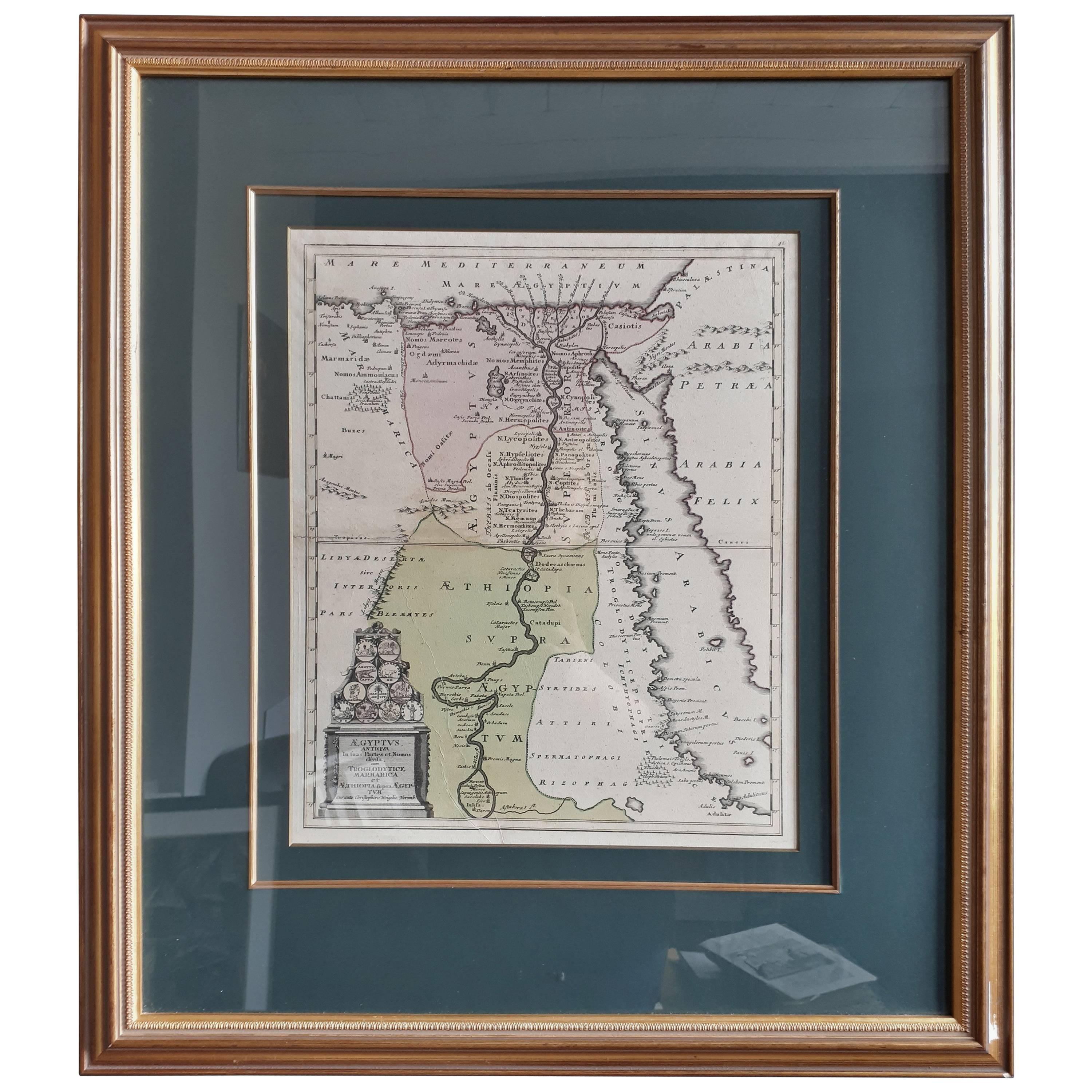
Original Antique Map of Egypt in Frame by C. Weigel, circa 1720
Located in Langweer, NL
The map is an antique depiction of ancient Egypt, divided into its regions and nomes, also including areas like Troglodytica, Marmarica, and Ethiopia above Egypt. Christophorus Weige...
Category
Antique Early 18th Century Maps
Materials
Paper
$938 Sale Price
20% Off
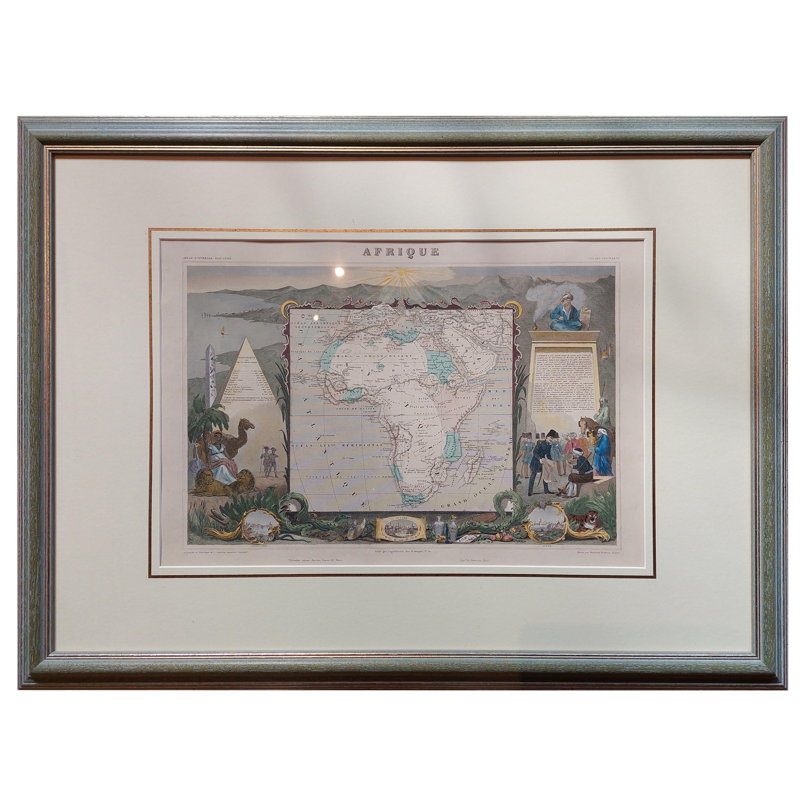
Antique Map of Africa by Levasseur 'c.1840'
Located in Langweer, NL
Antique map titled 'Afrique'. Original antique map of Africa. Decorative map of the continent surrounded by allegorical vignettes. Engraved by Raimond Bonheur, father of the famous F...
Category
Antique Mid-19th Century Maps
Materials
Paper
$481 Sale Price
20% Off
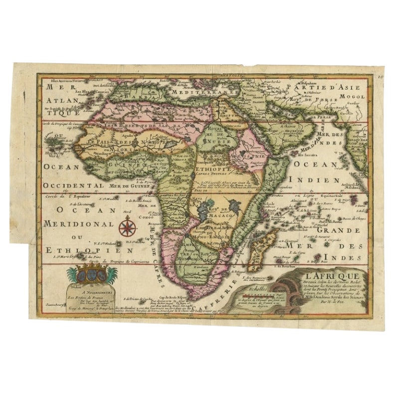
Antique Map of Africa with a Decorative Dedication to the Dauphin, 1717
Located in Langweer, NL
Antique map titled 'L'Afrique, Dressée Selon les Dernieres Relat. et Suivant les Nouvelles Decouvertes (..).'
This map is a reduced derivative of De Fer's wall map of Africa (1696-98) with its characteristic thickened west coast. Unusual islands appear in the Atlantic and Indian Oceans including a mythical second island of St. Helena. Monomotapa is shown in the south and the southwest coastline is distorted and there is an incorrect placement and shape of the Cape of Good Hope. In Central Africa is a paragraph concerning the origin of the Nile in Abyssinia, however, the two sub-equatorial Ptolemaic lakes are still shown on the map. The map is graced with a decorative dedication to the Dauphin and a title cartouche featuring lime kilns. The map was first published in 1700. This scarse map originates from: 'Introduction a la geographie - avec unde description historique sur toutes...
Category
Antique 18th Century Maps
Materials
Paper
$677 Sale Price
25% Off
Antique Lithography Map, West Africa, English, Framed, Cartography, Victorian
Located in Hele, Devon, GB
This is an antique lithography map of Western Africa. An English, framed atlas engraving of cartographic interest by John Rapkin, dating to the early Victorian period and later, circ...
Category
Antique Mid-19th Century British Early Victorian Maps
Materials
Wood

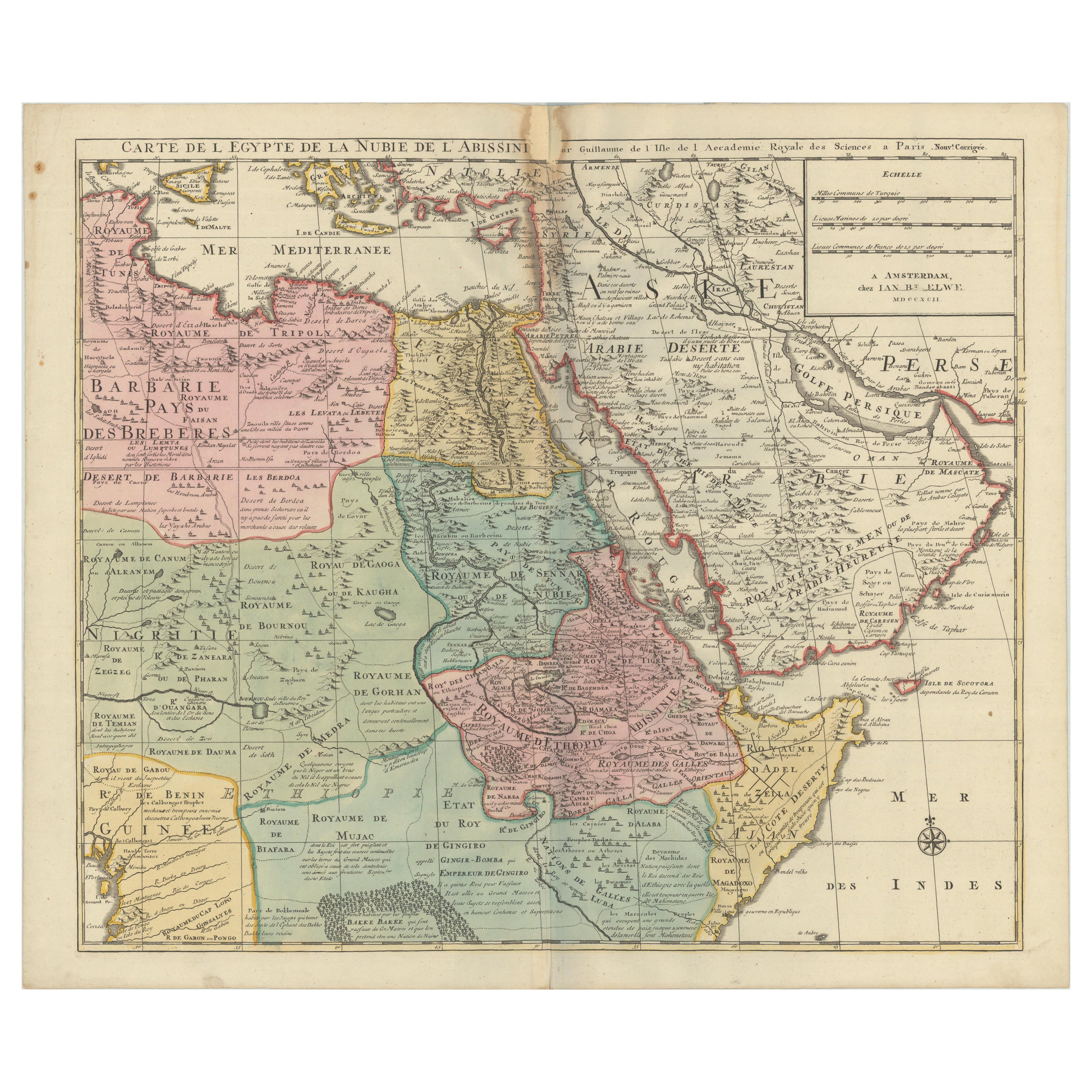
1792 Map of Eastern Africa and the Arabian Peninsula by Delisle/Elwe
Located in Langweer, NL
1792 Map of Eastern Africa and the Arabian Peninsula by Delisle/Elwe
This detailed 1792 map, created by Delisle and published by Elwe, depicts northeastern Africa, including Egypt, ...
Category
Antique 1790s Maps
Materials
Paper
$635 Sale Price
20% Off
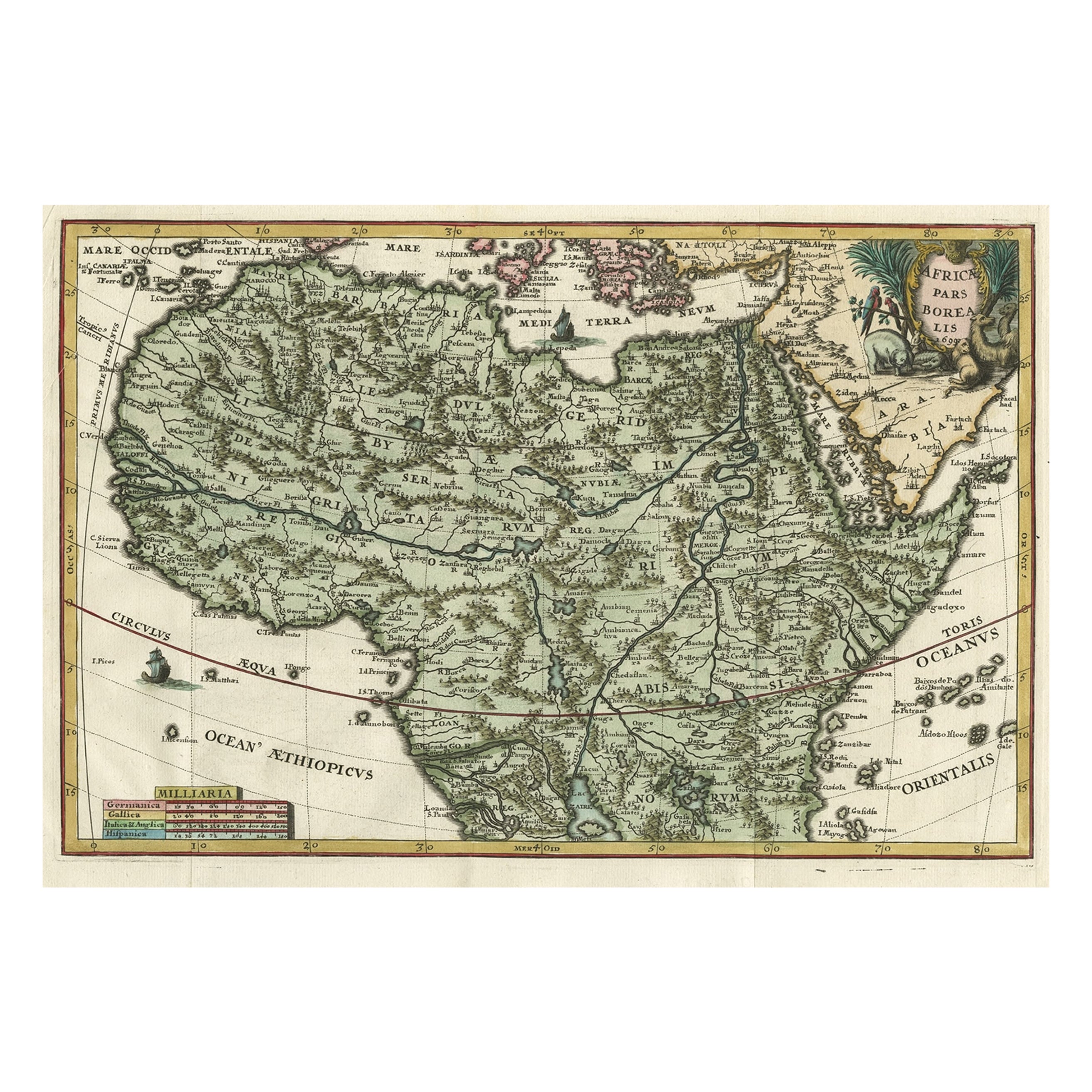
Very Decorative Rare Antique Map of the Northern Part of Africa, 1702
Located in Langweer, NL
Antique map titled 'Africae Pars Borealis.'
Very decorative antique map of the northern part of Africa by Heinrich Scherer. The map is full of the spurious geography of the perio...
Category
Antique Early 1700s Maps
Materials
Paper

$953 Sale Price
20% Off
More Ways To Browse
Pig Bench
Pineapple Chair
Pineapple Wallpaper
Pink Goblets
Pk9 Chairs
Polished Aluminum Counter Stools
Porcelain Coffee Mug
Porcelain Girl Basket Flowers
Porcelain Handle Knives
Porcelain Toucan
Porcelaine Empire
Porsgrund Norway
Portland Furniture Manufacturing Company
Postmodern Barrel Chairs
Pottery Goblet
Poul Kjaerholm Pk9 Chairs
Powder Jars
Prelude International Sterling