Items Similar to 1891 Map of Plymouth County Mass

Want more images or videos?
Request additional images or videos from the seller
1 of 11
1891 Map of Plymouth County Mass
$595
£451.47
€516.22
CA$831.05
A$924.02
CHF 482.47
MX$11,247.56
NOK 6,156.13
SEK 5,768
DKK 3,852.63
Shipping
Retrieving quote...The 1stDibs Promise:
Authenticity Guarantee,
Money-Back Guarantee,
24-Hour Cancellation
About the Item
Original 1891 map showing Sandwich, Bourne, Plymouth Carver, Middleborough, Plympton and Kingston. Showing Long Beach in Plymouth also as well as all shore points. Cape Cod Bay is marked on the map, marked George Walker 1891. This is Atlas Plate no. 7. Not a copy.
Weight: 8 lbs.
Overall Dimensions: 23"H x 31"W
Made: American
Material: Paper
Date: 1891
- Dimensions:Height: 23 in (58.42 cm)Width: 31 in (78.74 cm)Depth: 2 in (5.08 cm)
- Materials and Techniques:
- Place of Origin:
- Period:
- Date of Manufacture:1891
- Condition:
- Seller Location:Norwell, MA
- Reference Number:Seller: 81821stDibs: LU1741235627462
About the Seller
5.0
Vetted Professional Seller
Every seller passes strict standards for authenticity and reliability
Established in 1967
1stDibs seller since 2015
407 sales on 1stDibs
Typical response time: 3 hours
- ShippingRetrieving quote...Shipping from: Norwell, MA
- Return Policy
Authenticity Guarantee
In the unlikely event there’s an issue with an item’s authenticity, contact us within 1 year for a full refund. DetailsMoney-Back Guarantee
If your item is not as described, is damaged in transit, or does not arrive, contact us within 7 days for a full refund. Details24-Hour Cancellation
You have a 24-hour grace period in which to reconsider your purchase, with no questions asked.Vetted Professional Sellers
Our world-class sellers must adhere to strict standards for service and quality, maintaining the integrity of our listings.Price-Match Guarantee
If you find that a seller listed the same item for a lower price elsewhere, we’ll match it.Trusted Global Delivery
Our best-in-class carrier network provides specialized shipping options worldwide, including custom delivery.More From This Seller
View All1891 Map of Norfolk County Massachusetts
Located in Norwell, MA
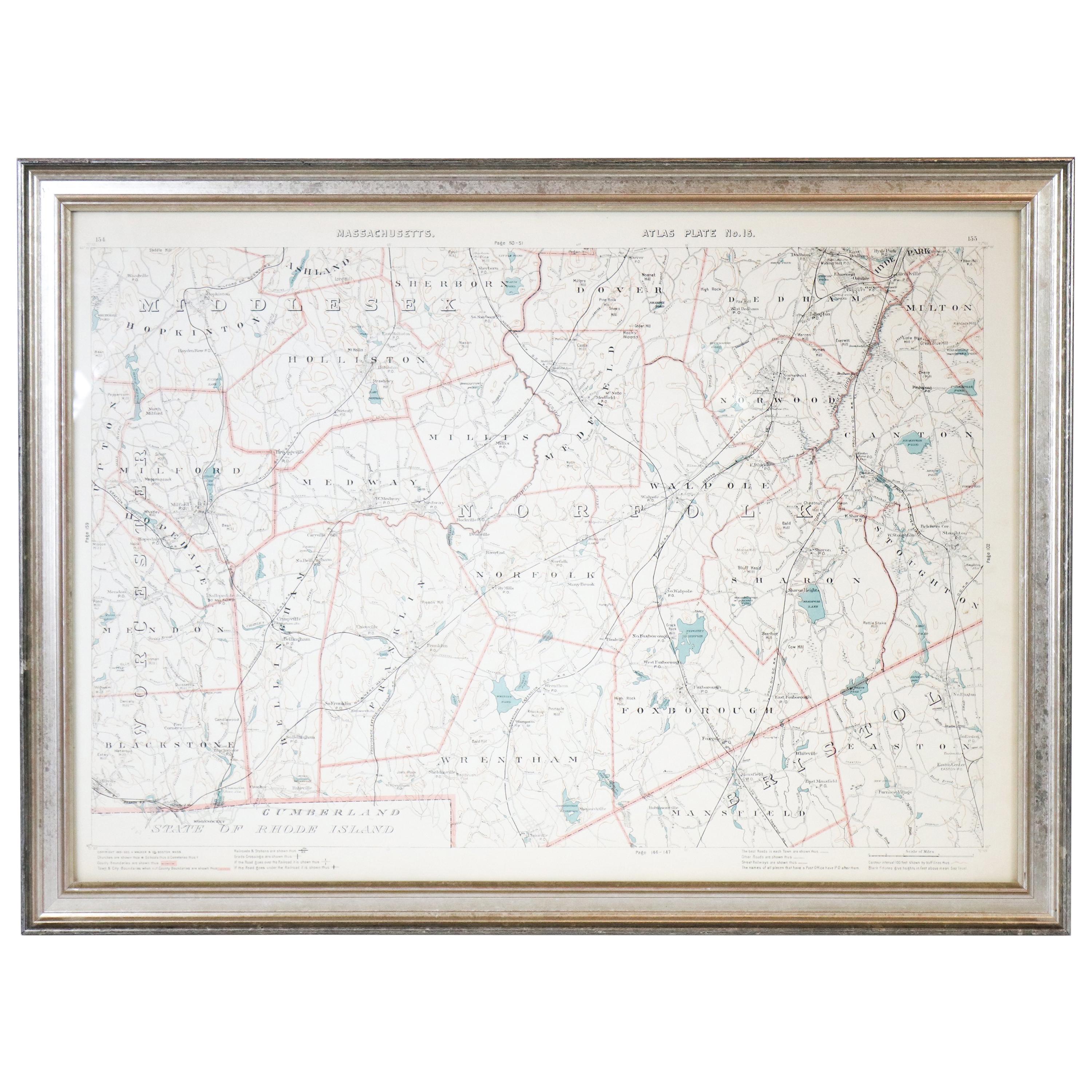
1891 map of Norfolk county Massachusetts including the towns of Wrentham, Franklin, Medfield, Sherborn, Norwood etc., measures: 23 x 31.
Category
Antique 19th Century Maps

1891 Map of South Shore of Boston
Located in Norwell, MA
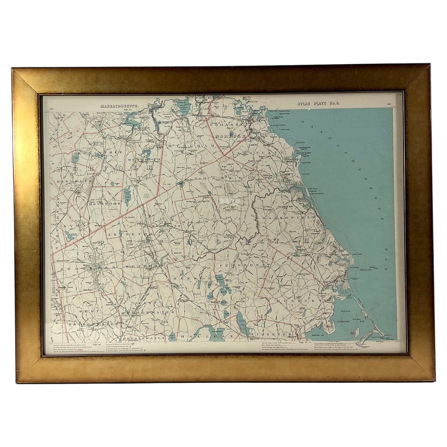
Original 1891 map showing Cohasset, Scituate, Marshfield, Duxbury, Kingston, Norwell, Hanover, Hingham, Hull, Holbrook, Weymouth, Hanson, Pembroke, etc. Framed with glass. Circa 1891.
Category
Antique 1890s North American Prints
Materials
Paper
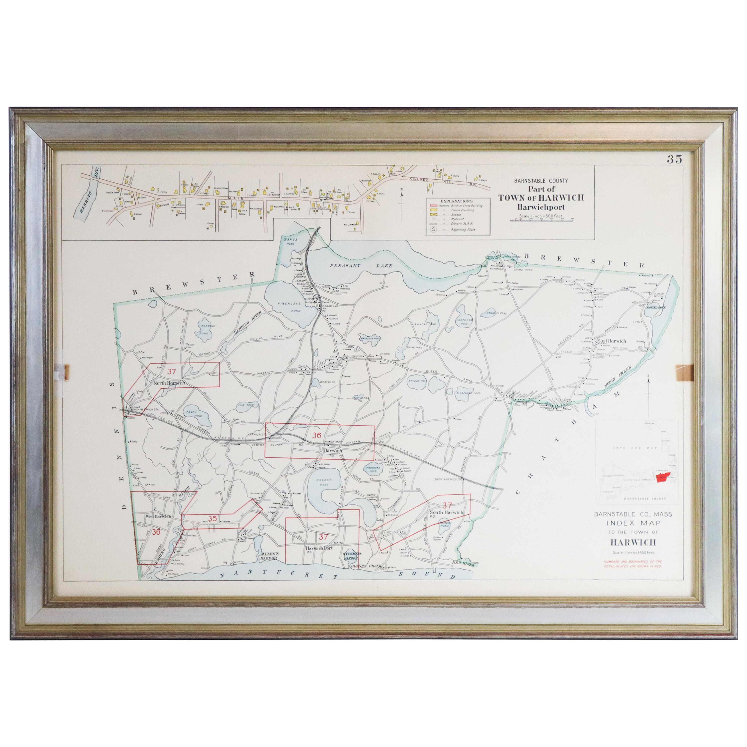
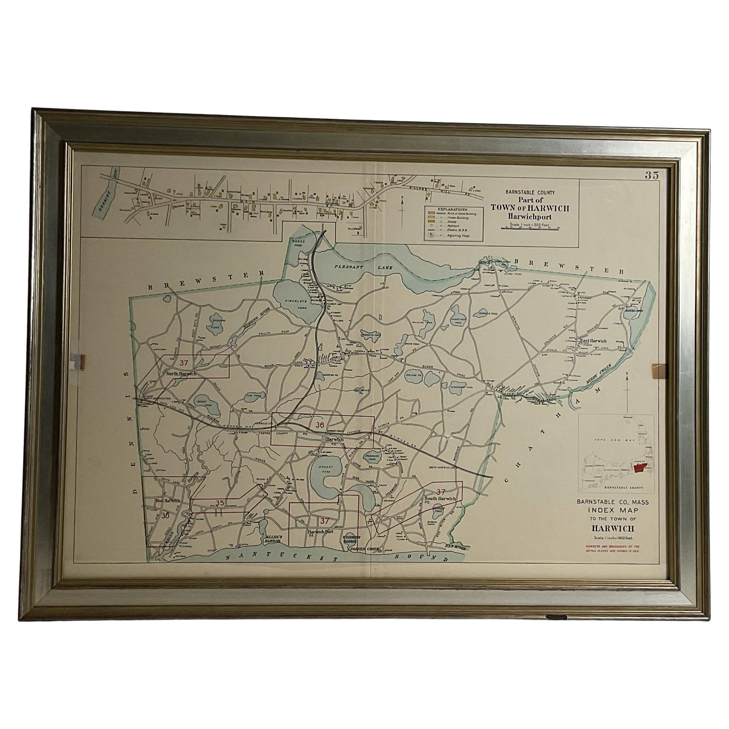
Map of Harwich, Massachusetts
Located in Norwell, MA
Turn of the century map of Harwich, Massachusetts. Plate from a Cape Cod County Map book showing the Barnstable county town of Harwich including Allens Harbor, Pleasant Lake, Harwich...
Category
20th Century Maps

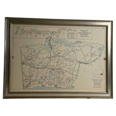
Wychmere Harbor Allens Harbor Map Circa 1890
Located in Norwell, MA
Map of Harwich Mass showing Wychmere Harbor, Doane's Creek, Allens Harbor, Herring River, Pleasant Lake, Grassy Pond, Paddocks Pond, Hinkleys Pond, etc., This is an original period m...
Category
Antique 1890s North American Maps
Materials
Paper
Original 1891 Walker Map
Located in Norwell, MA
Original 1891 map of Massachusetts by Walker. Towns include Cambridge, Boston, Dedham, Ashland, Brookline, Newton etc... burl wood frame. Measures...
Category
Antique 19th Century Maps

1873 Martha's Vineyard and Nantucket Chart
Located in Norwell, MA
Original chart of Nantucket and Martha's Vineyard by George Eldridge, Cartographer, 125 State Street, Boston. Dated 1873. Mounted to canvas. Also showing the coast of Cape Cod includ...
Category
Antique 1870s North American Maps
Materials
Paper

You May Also Like
Original Antique Map of the American State of Massachusetts, 1903
Located in St Annes, Lancashire
Antique map of Vermont and New Hampshire
Published By A & C Black. 1903
Original colour
Good condition
Unframed.
Free shipping
Category
Antique Early 1900s English Maps
Materials
Paper

Large Original Antique Map of Massachusetts, USA, circa 1900
Located in St Annes, Lancashire
Fabulous map of Massachusetts
In 2 sheets. They can be joined but I have not done it
Original color
Engraved and printed by the George F. Cram ...
Category
Antique 1890s American Maps
Materials
Paper

Original Antique Map of the American State of Connecticut & Rhode Island, 1903
Located in St Annes, Lancashire
Antique map of Connecticut and Rhode Island
Published By A & C Black. 1903
Original colour
Good condition
Unframed.
Free shipping
Category
Antique Early 1900s English Maps
Materials
Paper

1854 Map of Massachusetts, Connecticut and Rhode Island, Antique Wall Map
Located in Colorado Springs, CO
This striking wall map was published in 1854 by Ensign, Bridgman & Fanning and has both full original hand-coloring and original hardware. This impression is both informative and highly decorative.
The states are divided into counties, outlined in red, green, and black, and subdivided into towns. Roads, canals, and railroad lines are prominently depicted, although they are not all labeled. The mapmakers also marked lighthouses, banks, churches, and prominent buildings, with a key at right. The map is an informative and comprehensive overview of the infrastructural development of New England prior to the Civil War. Physical geographies depicted include elevation, conveyed with hachure marks, rivers and lakes. The impression features an inset map of Boston...
Category
Antique 19th Century American Maps
Materials
Paper

1872 Map of Hudson, Union and Essex Counties, New Jersey
Located in Savannah, GA
A hand-colored topographical map of New Jersey’s Hudson, Union and Essex Counties from the Atlas of New Jersey by F.W. Beers, published in 1872.
sight 15 by 22½ inches
frame 20 by...
Category
Antique 1870s American Prints
Materials
Glass, Wood, Paper

Large Original Antique Map of New York State( Southern ), USA, C.1900
Located in St Annes, Lancashire
Fabulous map of Southern New York . With a vignette of Lower Manhattan
Original color.
Engraved and printed by the George F. Cram Company, Indianapolis.
Published, C.1900.
Unfram...
Category
Antique 1890s American Maps
Materials
Paper

More Ways To Browse
Used Furniture North Bay
Used Furniture Cape Cod
Used Furniture Plymouth
Antique Sandwich Plates
Playful Chair
Giacometti Chairs
Antique Rug Wool Navy Blue Red
Bauhaus Flower Stand
French Table With Drawers
North Carolina Furniture
Antique Silver Platter
Boat Blueprint
Cream Plates
Vintage Art Deco Rugs
Vintage Serving Forks
Brewery Signs
Herati Rug
Venice Wood