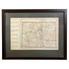
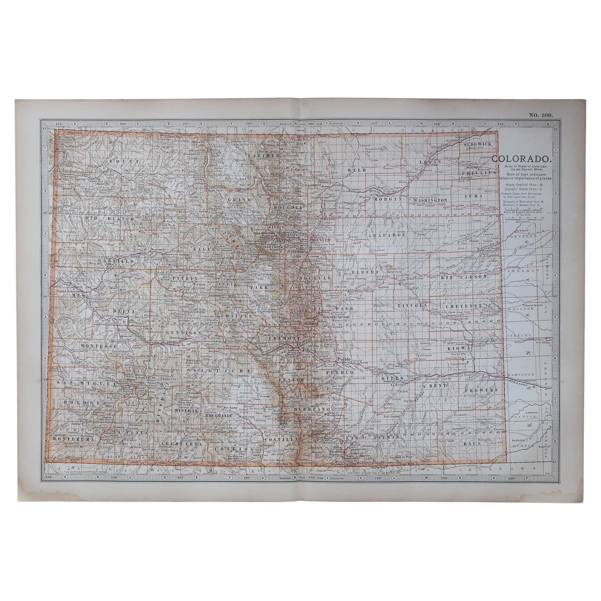
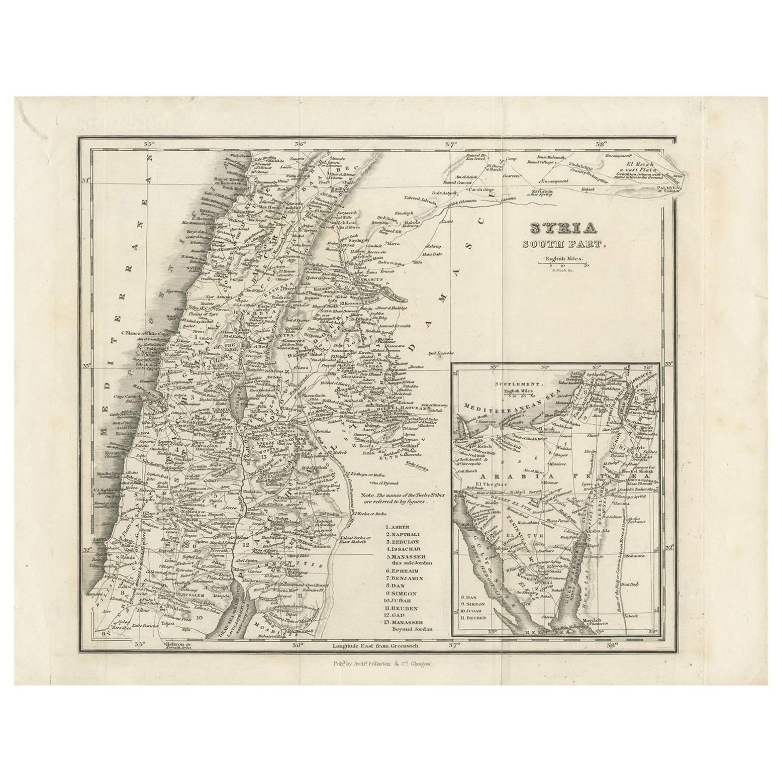
1925 "Colorado" Map by L. L. Poates Eng. Co.
View Similar Items


Want more images or videos?
Request additional images or videos from the seller
1 of 6
1925 "Colorado" Map by L. L. Poates Eng. Co.
Price:$850
About the Item
- Dimensions:Height: 14.25 in (36.2 cm)Width: 18.25 in (46.36 cm)Depth: 0.75 in (1.91 cm)
- Style:Arts and Crafts (Of the Period)
- Materials and Techniques:
- Place of Origin:
- Period:
- Date of Manufacture:1925
- Condition:Additions or alterations made to the original: Framed by Rio Grande Custom Framing in Colorado Springs, CO, in December of 2024. Wear consistent with age and use.
- Seller Location:Colorado Springs, CO
- Reference Number:Seller: M3711stDibs: LU909742864232
About the Seller
4.9
Platinum Seller
Premium sellers with a 4.7+ rating and 24-hour response times
Established in 2010
1stDibs seller since 2011
463 sales on 1stDibs
Authenticity Guarantee
In the unlikely event there’s an issue with an item’s authenticity, contact us within 1 year for a full refund. DetailsMoney-Back Guarantee
If your item is not as described, is damaged in transit, or does not arrive, contact us within 7 days for a full refund. Details24-Hour Cancellation
You have a 24-hour grace period in which to reconsider your purchase, with no questions asked.Vetted Professional Sellers
Our world-class sellers must adhere to strict standards for service and quality, maintaining the integrity of our listings.Price-Match Guarantee
If you find that a seller listed the same item for a lower price elsewhere, we’ll match it.Trusted Global Delivery
Our best-in-class carrier network provides specialized shipping options worldwide, including custom delivery.More From This Seller
View All1904 "Nell's Topographical Map of the State of Colorado"
Located in Colorado Springs, CO
This highly detailed pocket map is a topographical map of the state of Colorado by Louis Nell from 1904. The map "has been compiled from all available...
Category
Antique Early 1900s American Maps
Materials
Leather, Paper

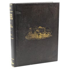
The Flag of the United States by Harrison S. Kerrick, First Edition, 1925
Located in Colorado Springs, CO
Kerrick, Harrison S. The Flag of the United States: Your Flag and Mine. Columbus: The Champlin Printing Co., 1925. First Edition, Second Printing. In original blue cloth boards, with gilt embossed title to the front board. New archival cloth slipcase.
Presented is a first edition, second printing of The Flag of the United States: Your Flag and Mine by Harrison S. Kerrick. This book was published by The Champlin Printing Co. in Columbus, Ohio. The first edition, first printing of this title was issued in February of 1925; this second printing was issued in April of 1925.
This book is a culmination of lifelong passion and respect for the American flag by the author Harrison S. Kerrick. The book begins by detailing the acts of continental and national Congresses, presidential proclamations, and Executive Orders that established the United States flag and Great Seal. He discusses the state laws pertaining to the American flag and argues the importance of a national flag code. Kerrick delves into the past history of flag design, including which European flags were popular in the early colonies, the early banners of the colonies, and the design elements that make up the stars and stripes as we know it today. He spends two chapters covering the facts and fictional myths surrounding our national flag. He then details how best to use the flag for personal and public use, inclduding how to create a flag, care for a flag, and the codes of conduct surrounding the proper display of the flag.
Lieutenant colonel Harrison Summers Kerrick (1873 – 1939) was an United States Army officer, teacher, and author. Kerrick was born in 1873 in Bloomington, Illinois, and attended Illinois Wesleyan University. In 1898, he enlisted in Company C of the 2nd Illinois Volunteer Infantry, serving in the Spanish–American War, during which he was promoted to captain. He served as a field artillery officer in the Philippine–American War and in WWI, he served in the U.S. Army Coast Artillery Corps from December 1917 to February 1918.
A lecturer and teacher, Kerrick was also the author of two books, Military and Naval America and The Flag of the United States. Passionate about American history and the symbolism of the American flag, Kerrick created the code of conduct on the proper handling and display of the United States flag, which was later adopted by the United States Congress...
Category
Vintage 1920s American Arts and Crafts Books
Materials
Paper
1812 United States Map, by Pierre Tardieu, Antique French Map Depicting the U.S.
By Pierre François Tardieu
Located in Colorado Springs, CO
1812 "United States of Nth America -- Carte des Etats-Unis De L'Amerique Septentrionale" Two-Sheet Map by Tardieu
This attractive map, published in Paris in 1812, is one of the most rare large format maps from the period. It features a view of the East Coast of the U.S. from Maryland to just below South Carolina. Additionally, Ellicott’s plan for the City of Washington D.C. is included at the top right and an illustration of Niagara Falls is shown at the bottom right with a description in both French and English. This extremely detailed map not only depicts the mountainous regions of the southeastern U.S., but also includes names of regions, rivers, and towns.
Based on the first state of Arrowsmith’s 4-sheet map of the United States, this map is completely engraved by Tardieu in Paris and showcases high quality engravings. This detailed map of the recently independent United States includes one of the largest and earliest examples of the Ellicott plan of Washington DC.
The artist, Pierre François Tardieu (PF Tardieu) was a very well-known map engraver, geographer, and illustrator. Awarded a bronze medal by King Louis-Phillipe for the accuracy and beauty of his map-making, Tardieu produced many fine works including maps of Louisiana...
Category
Antique 1810s French Maps
Materials
Paper

1846 "North America" Map, Engraved by I. Dower
Located in Colorado Springs, CO
Presented is an original 1846 map of “North America.” The map was drawn and engraved by I. Dower and published in London by Orr & Company. The map depicts North America, to include G...
Category
Antique 1840s English Victorian Maps
Materials
Paper

1864 Map of North America, Antique Hand-Colored Map, by Adolphe Hippolyte Dufour
Located in Colorado Springs, CO
Offered is a map of North America entitled Amerique du Nord from 1864. This rare, separately published wall map was produced by Adolphe Hippolyte Dufour. This map includes vibrant an...
Category
Antique 1860s French Maps
Materials
Paper

Report upon the Colorado River of the West by Joseph Ives, First Edition, 1861
Located in Colorado Springs, CO
Ives, Joseph Christmas. Report upon the Colorado River of the West. Washington: Government Printing Office, 1861. First Edition, Senate Issue. Extensively illustrated with maps, engr...
Category
Antique 1860s American Books
Materials
Fabric, Paper
You May Also Like
Original Antique Map of the American State of Colorado, 1903
Located in St Annes, Lancashire
Antique map of Colorado
Published By A & C Black. 1903
Original colour
Good condition
Unframed.
Free shipping
Category
Antique Early 1900s English Maps
Materials
Paper

Antique Map of California, Utah, Nevada, Colorado, New Mexico & Arizona '1872'
Located in Langweer, NL
Antique map titled 'Johnson's California (..)'. Original map of California, Utah, Nevada, Colorado, New Mexico and Arizona. This map originates from ...
Category
Antique Late 19th Century Maps
Materials
Paper

$238 Sale Price
20% Off
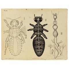
Zoological Lithograph of a Cockroach 1925 Cardboard by H Aschehoug & Co Norway
Located in Milan, IT
Zoological didactic plate n. 64 lithograph on cardboard made in 1925 depicting an enlarged cockroach with the digestive and reproductive system. Dybdhals Zoologiske Plancher P.M.Bye ...
Category
Vintage 1920s Norwegian Prints
Materials
Paper
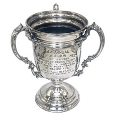
Thomas F. Garvin Trophy, 1925 Aviation Trophy, by Wilcox Silver Plate Co.
By Wilcox Silver Plate Co.
Located in West Palm Beach, FL
Thomas F. Garvin Trophy, 1925 Aviation Trophy, by Wilcox Silver Plate Co.
Measuring approximately 14 inches high by 11 inches wide and 11 inches deep, this silver-plated trophy stands...
Category
Early 20th Century American Neoclassical Historical Memorabilia
Materials
Silver Plate
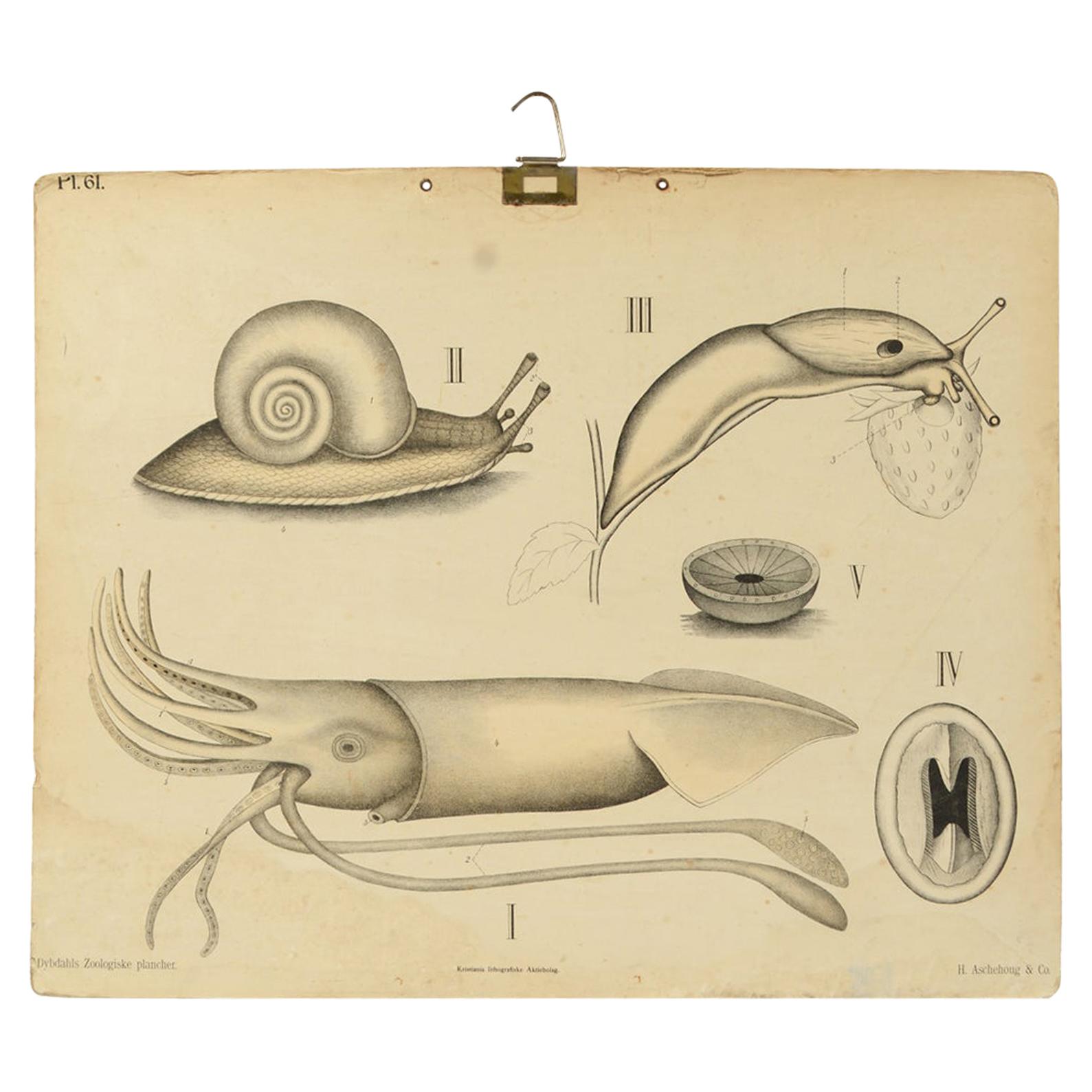
Zoological Lithograph of molluscs 1925 on Cardboard by H Aschehoug & Co, Norway
Located in Milan, IT
Zoological didactic plate Pl 61, colored lithograph on cardboard made in 1925 depicting molluscs. Dybdhals Zoologiske Plancher Kristiania lithografiske aktielbolag. Made by H Ascheho...
Category
Vintage 1910s Norwegian Prints
Materials
Paper
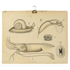
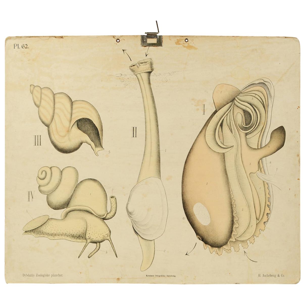
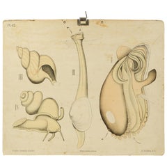
Zoological Lithograph of Molluscs 1925 on Cardboard by H Aschehoug & Co Norway
Located in Milan, IT
Zoological didactic plate n. 62 lithograph on cardboard made in 1925 depicting molluscs. Dybdhals Zoologiske Plancher P.M.Bye & Co Oslo. Made by H Aschehoug & Co. Good condition. Mea...
Category
Vintage 1920s Norwegian Prints
Materials
Paper
Recently Viewed
View AllMore Ways To Browse
American Indian Statue
Indian Reverse Glass
Atlas Statue
Wooden Indian Statue
Antique Wooden Indian Statues
Red Retro Dining Set
Antique Silver Glasses Case
Carlo Scarpa 1934 Chairs
Christofle Marly
1900 Antique Chairs
Glass Table Italian Round
Mid Century Colonial
Alvar Aalto Poster
Geometric Metal Table
Post Modern High Chairs
United Nations
Vintage Vine Rug
Cancel An Order