Items Similar to 1927 "Texas" Map by C.S. Hammond

Want more images or videos?
Request additional images or videos from the seller
1 of 9
1927 "Texas" Map by C.S. Hammond
$950
£729.56
€836.07
CA$1,337.37
A$1,498.14
CHF 779.22
MX$18,274.27
NOK 9,920.53
SEK 9,354.35
DKK 6,240.17
About the Item
Presented is a very detailed map of Texas, printed in 1927. The map was featured in The Literary Digest Atlas of the World and Gazetteer, published by Funk & Wagnalls. The map is small but comprehensive, colored in yellow and outlined in green. The map shows the rivers, cities, towns, and settlements throughout Texas. It also details the roads and completed railroads that cross through the area. An inset map of the western portion of Texas appears on the lower left corner.
The population of Texas grew rapidly at the end of the 19th century into the early 20th century, from 1,591,749 in 1880 to 2,235,527 by 1890, 3,048,710 in 1900 and reached approximately 5,577,000 in 1927, when this map was published. The expanding population spread westward to complete settlement of the state by establishing communities on the South Plains, in the Panhandle, and beyond the Pecos River. The growth was stimulated by the development of ranching and commercial farming, which was aided by the new network of railroads criss-crossing the state.
Looking at the county configurations is very telling of the burgeoning development in Texas at the time. For example, Tom Green County, once larger than the state of Massachusetts and Connecticut combined, is shown fully divided into much smaller counties like Loving, Winkler, Ector, Ward, Crane, Upton, Midland, and Glasscock, Coke, and Sterling. Smaller towns and cities now fill in the panhandle of Texas and railroads continue all the way to El Paso, with many stops along the way. This map also shows bordering Oklahoma as a state, rather than Indian Territory.
CONDITION:
Very good condition. Printed color. Clean and bright paper, with narrow margins. Issued originally in an atlas.
Framed Dimensions: 12 1/2"H x 10"W x 3/4"D.
Accompanied by our company's letter of authenticity.
- Dimensions:Height: 12.5 in (31.75 cm)Width: 10 in (25.4 cm)Depth: 0.75 in (1.91 cm)
- Materials and Techniques:
- Place of Origin:
- Period:
- Date of Manufacture:1927
- Condition:Additions or alterations made to the original: Archival framing by Artem Art Services in Colorado Springs, CO, in July of 2025. Wear consistent with age and use.
- Seller Location:Colorado Springs, CO
- Reference Number:Seller: M3721stDibs: LU909746082952
About the Seller
4.9
Platinum Seller
Premium sellers with a 4.7+ rating and 24-hour response times
Established in 2010
1stDibs seller since 2011
462 sales on 1stDibs
- ShippingRetrieving quote...Shipping from: Colorado Springs, CO
- Return Policy
Authenticity Guarantee
In the unlikely event there’s an issue with an item’s authenticity, contact us within 1 year for a full refund. DetailsMoney-Back Guarantee
If your item is not as described, is damaged in transit, or does not arrive, contact us within 7 days for a full refund. Details24-Hour Cancellation
You have a 24-hour grace period in which to reconsider your purchase, with no questions asked.Vetted Professional Sellers
Our world-class sellers must adhere to strict standards for service and quality, maintaining the integrity of our listings.Price-Match Guarantee
If you find that a seller listed the same item for a lower price elsewhere, we’ll match it.Trusted Global Delivery
Our best-in-class carrier network provides specialized shipping options worldwide, including custom delivery.More From This Seller
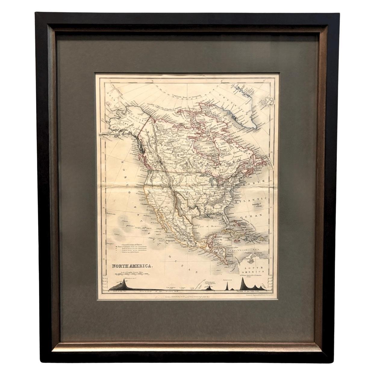
View All1846 "North America" Map, Engraved by I. Dower
Located in Colorado Springs, CO
Presented is an original 1846 map of “North America.” The map was drawn and engraved by I. Dower and published in London by Orr & Company. The map depicts North America, to include G...
Category
Antique 1840s English Victorian Maps
Materials
Paper

1864 Map of North America, Antique Hand-Colored Map, by Adolphe Hippolyte Dufour
Located in Colorado Springs, CO
Offered is a map of North America entitled Amerique du Nord from 1864. This rare, separately published wall map was produced by Adolphe Hippolyte Dufour. This map includes vibrant an...
Category
Antique 1860s French Maps
Materials
Paper

1890 "Map of Oregon, Kansas, California, and the Territories" by S. A. Mitchell
By Samuel Augustus Mitchell 1
Located in Colorado Springs, CO
Presented is an 1890 map "Map of Oregon, Kansas, California, and the Territories" by S. A. Mitchell Jr. The map was issued in the atlas “Mitchell's New Intermediate Geography” publis...
Category
Antique 1890s American Victorian Maps
Materials
Paper

1859 "Map of the United States of America..." by J. H. Colton
By J.H. Colton
Located in Colorado Springs, CO
Presented is an 1859 “Map of the United States of America, the British Provinces, Mexico, the West Indies and Central America with Part of...
Category
Antique 1850s American Maps
Materials
Paper

1847 Antique Map of Mexico, Texas and California by Samuel Augustus Mitchell
By Samuel Augustus Mitchell 1
Located in Colorado Springs, CO
Presented is the second edition of Samuel Augustus Mitchell's Map of Mexico, Including Yucatan & Upper California, an important map showing the progress of the Mexican-American War. ...
Category
Antique 1840s American Maps
Materials
Paper

1939 "A Good-Natured Map of the United States" by Greyhound
Located in Colorado Springs, CO
Presented is an original 1939 map, titled “A Good-Natured Map of the United States Setting Forth the Services of the Greyhound Lines and a Few Principal Connecting Bus Lines.” This brightly colored pictographic map was one of several similar United States maps...
Category
Vintage 1930s American Art Deco Maps
Materials
Paper

You May Also Like
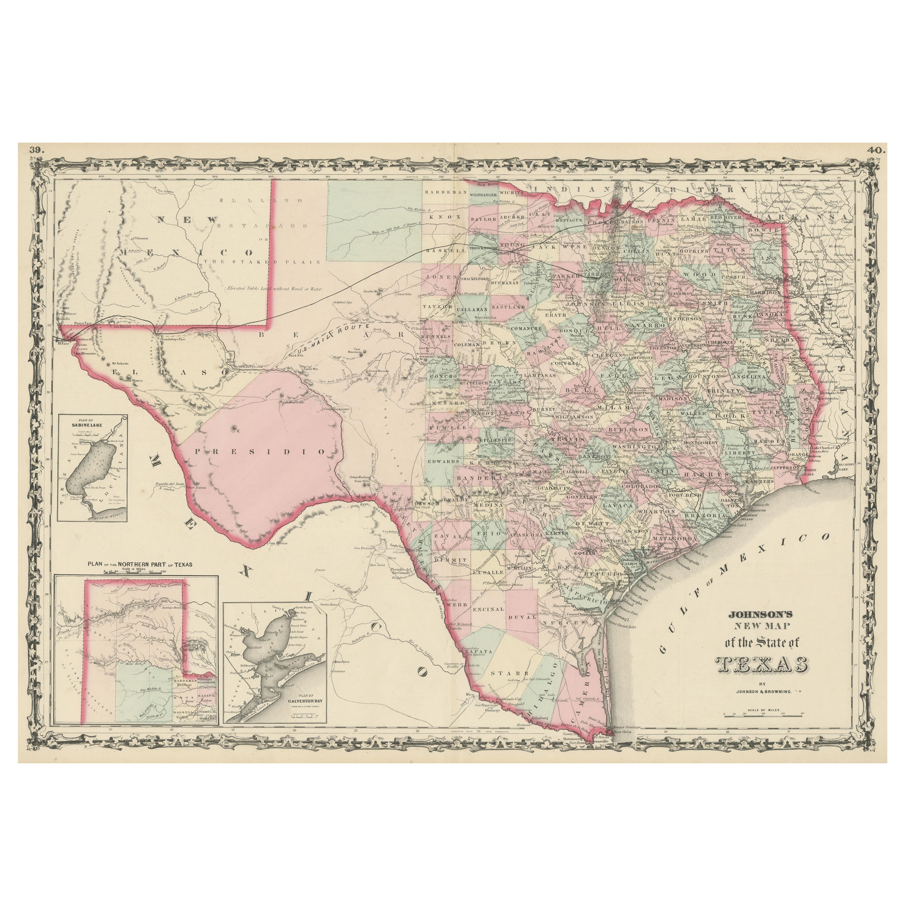
Large Antique Map of the State of Texas, 1861
Located in Langweer, NL
Antique map titled 'Johnson's New Map of the State of Texas' Large map of Texas, shows railroads, wagon roads, the U.S. Mail Route, rivers, ports, ...
Category
Antique Mid-19th Century American Maps
Materials
Paper

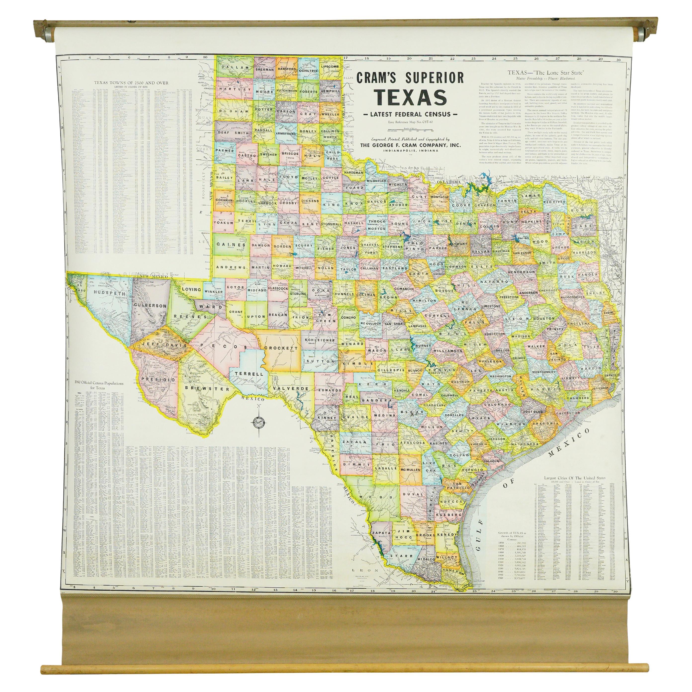
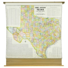
1850-1960 Cram's Superior Latest Federal Census Texas Map
By G. F. Cram Company
Located in New York, NY
The 1850-1960 Cram's Superior Latest Federal Census Texas Map, crafted from pine wood, steel, and canvas, is a valuable historical cartographic piece. Publi...
Category
Vintage 1910s American Maps
Materials
Canvas
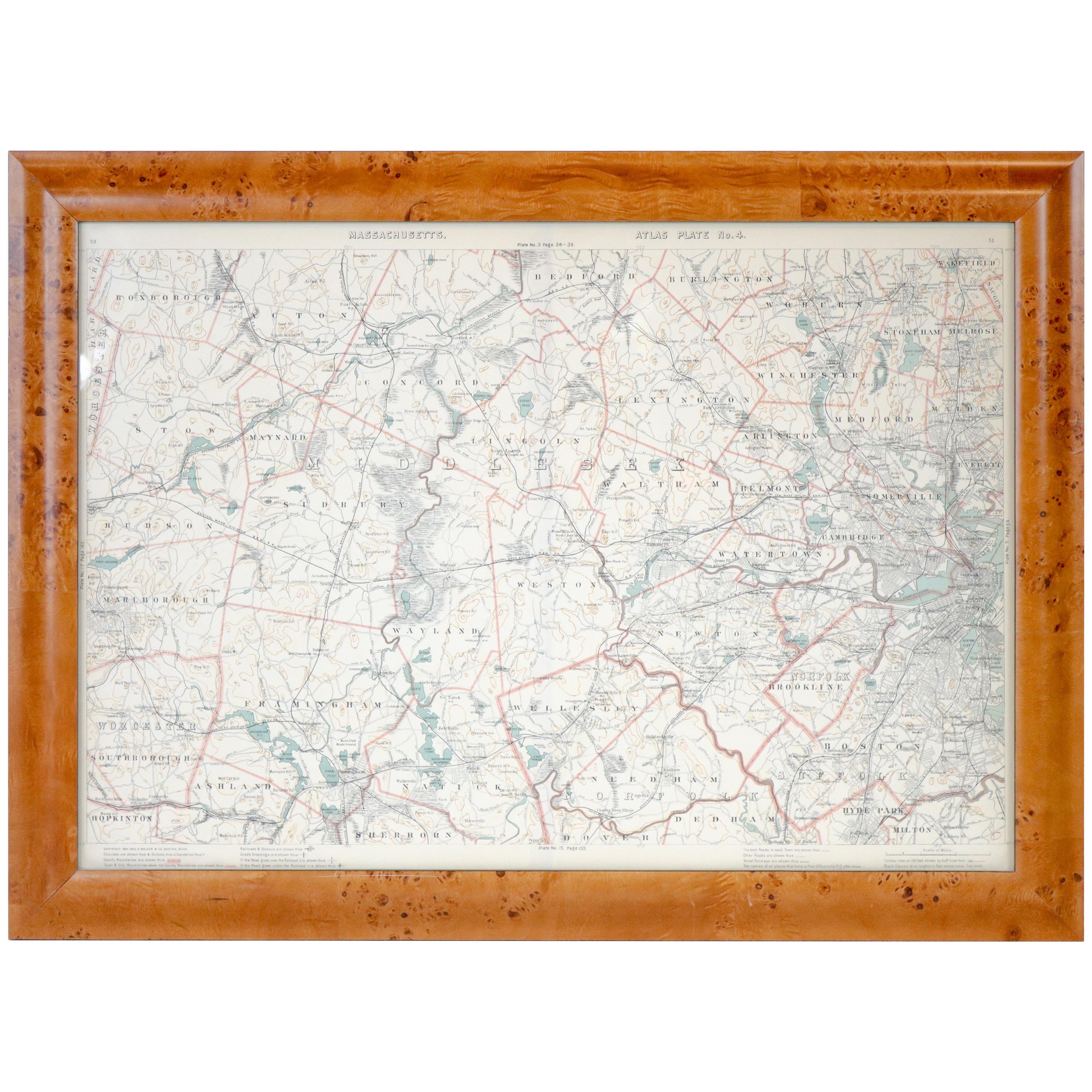
Original 1891 Walker Map
Located in Norwell, MA
Original 1891 map of Massachusetts by Walker. Towns include Cambridge, Boston, Dedham, Ashland, Brookline, Newton etc... burl wood frame. Measures...
Category
Antique 19th Century Maps

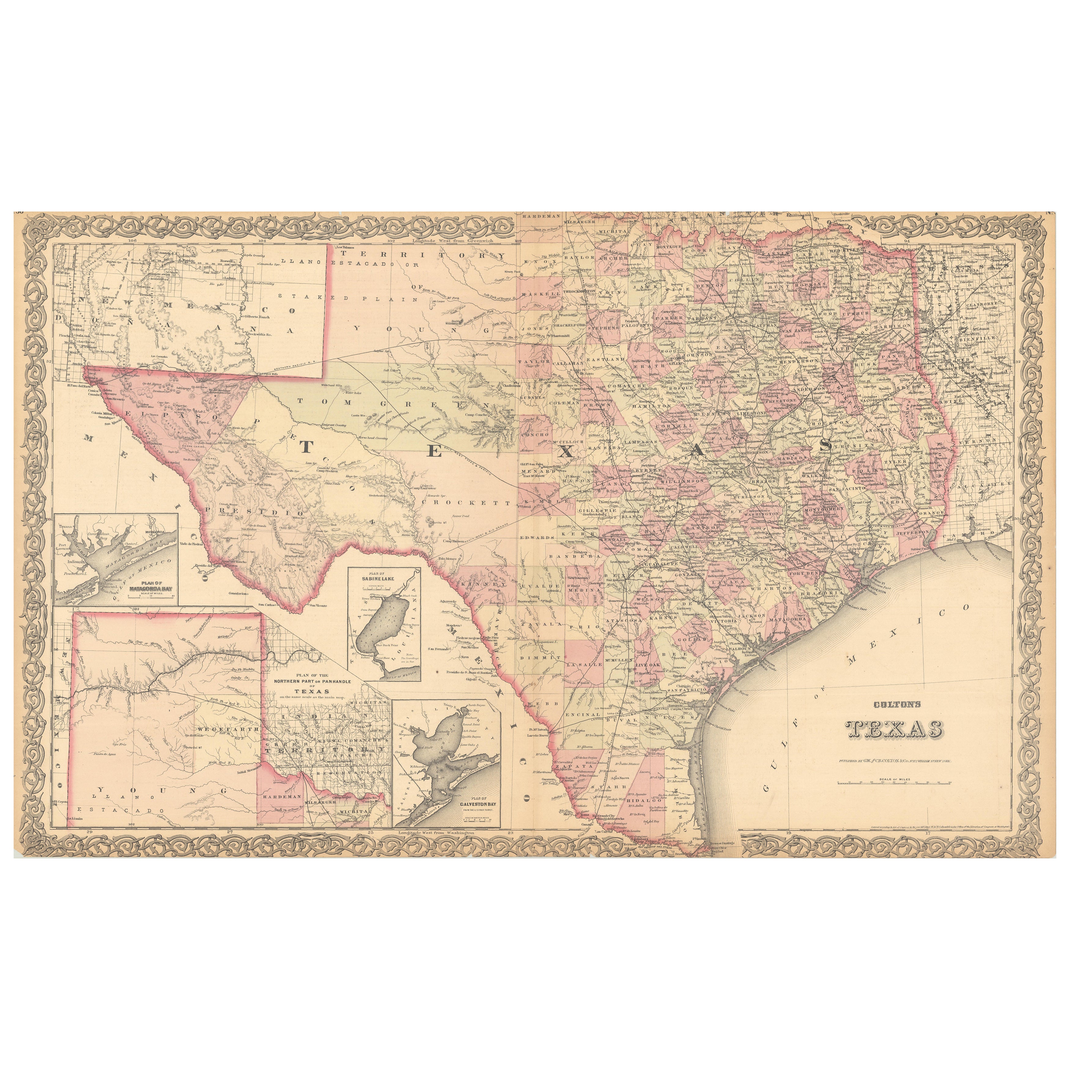
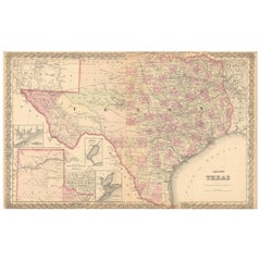
Large Antique Map of Texas with Panhandle & Bay Inset Maps, Colton, 1873
Located in Langweer, NL
Large Antique Map of Texas with Panhandle & Bay Inset Maps, Colton, 1873
This richly detailed and visually striking antique map of Texas was pub...
Category
Antique 1870s Maps
Materials
Paper
Vintage Framed United States Map
Located in Queens, NY
Vintage aged paper map of the United States mounted on particle board and framed in a simple wooden frame.
Category
20th Century American Mid-Century Modern Maps
Materials
Wood, Paper

Antique Map of the Eastern United States with Inset Map of Texas
Located in Langweer, NL
Antique map titled 'Verein-Staaten von Nord-America mit Ausnahme Florida's und der Westlichen Territorien'. This map extends as far west as Louisiana and only includes the northern p...
Category
Antique Mid-19th Century Maps
Materials
Paper

$510 Sale Price
20% Off