Items Similar to 1859 "Map of the United States of America..." by J. H. Colton


Video Loading
Want more images or videos?
Request additional images or videos from the seller
1 of 6
1859 "Map of the United States of America..." by J. H. Colton
About the Item
Presented is an 1859 “Map of the United States of America, the British Provinces, Mexico, the West Indies and Central America with Part of New Granada and Venezuela” by John Hutchinson Colton. First published in 1848, this map was updated in 1859 and shows the progress of the years since its earlier issues. The large hand-colored engraved case map depicts the United States in the mid-19th century, before the Civil War.
The map has an elaborate and decorative pictorial border, with scenes of the “US Capitol,” “Entrance of a Port,” “Mexicans Catching Wild Cattle,” “Cathedral City of Mexico,” “Willamette Falls, Oregon,” “Astoria, Oregon,” “Saratoga Lake, New York”, “Valley of the Connecticut,” as well as four monuments, inset into the border. The intertwined grapevine border is dotted with scenes of fishing, farming, and beautiful vistas across the top of the map. The bottom vignettes show ranching and shipping.
A dramatic, emblematic title vignette features an American bald eagle, atop a patriotic shield. With an olive branch in one talon and arrows in the other, the eagle is flanked on its left by a cornucopia overflowing with fruits and vegetables. Farming equipment is engraved behind. On its right are tools of navigation, exploration, shipping, and trade. The background is a large port city connected by steam railroad and steam-powered paddleboat, highlighting the many possibilities for interior trade along railways, canals, and rivers.
Emphasizing the commercial prosperity of the Americas, there are several ships shown on the waterways. Additionally, there appears a “Table of Distances” to major ports in North America, as well as across the Caribbean and South America. A large inset map on the lower left shows the Atlantic Ocean and its bordering continents, serving to illustrate the booming transatlantic commerce.
This map was published in 1859; after the Mexican-American War and during the height of gold prospecting and mining in the west and the influx of new settlers. Texas’ borders are updated to reflect both the Adams-Onís Treaty of 1819 and the Compromise of 1850. Roads between major cities, as well as exploration and travel routes, crisscross the state. Captain Randolph Marcy’s 1849 route from Arkansas to New Mexico then back across Texas appears on the map, as well as the Comanche Trail south into the Mexican State of Coahuila. The southern borders of Arizona and New Mexico reflect the recent Gadsden Purchase. The map also includes the Washington Territory, Kansas Territory, and the new state of Minnesota. The map was updated from Colton's earlier editions to reflect the best available information from the western portion of the country.
The Colton family led the market in the American map trade during the nineteenth century. The business was founded by Joseph Hutchins Colton (1800-1893). By the 1850's, their output expanded to include original maps, guidebooks, atlases, and railroad maps. Joseph was succeeded by his sons, George Woolworth (1827-1901) and Charles B. Colton (1831-1916), at which time the firm was renamed G. W. & C. B. Colton.
CONDITION:
Map in good condition. Map is dissected into its 32 segments and mounted to linen, with silk selvage and original marbled self-wrappers. A lithographed date label pasted below imprint. Small repairs were made by the previous owner. The map retains a nice aged patina. Map Dimensions: 35” H x 45” W .
Map has been archivally framed in a custom-built black and gold frame, with golden spandrels, UV plexiglas, and a custom plaque. Framed Dimensions: 49"H x 59"W x 4 1/4" D.
- Creator:J.H. Colton (Artist)
- Dimensions:Height: 49 in (124.46 cm)Width: 59 in (149.86 cm)Depth: 4.25 in (10.8 cm)
- Materials and Techniques:Paper,Engraved
- Place of Origin:
- Period:
- Date of Manufacture:1859
- Condition:Repaired: Small repairs were made by the previous owner. Additions or alterations made to the original: Mounted and framed to the highest archival standards by Art Source International in Boulder, CO in 2022. Wear consistent with age and use. Minor fading.
- Seller Location:Colorado Springs, CO
- Reference Number:
About the Seller
4.9
Platinum Seller
These expertly vetted sellers are 1stDibs' most experienced sellers and are rated highest by our customers.
Established in 2010
1stDibs seller since 2011
400 sales on 1stDibs
Typical response time: <1 hour
- ShippingRetrieving quote...Ships From: Colorado Springs, CO
- Return PolicyA return for this item may be initiated within 10 days of delivery.
More From This SellerView All
- 1859 "Colton's New Map of the State of Texas..." by Johnson & BrowningLocated in Colorado Springs, COPresented is "Colton's New Map of the State of Texas Compiled from De Cordova's Large Map", published in Alivin J. Johnson’s “New Illustrated Family Atlas.” The map was published in ...Category
Antique 1850s American Maps
MaterialsPaper
- 1847 Ornamental Map of the United States & Mexico by H. PhelpsLocated in Colorado Springs, COOffered is an original 1847 ornamental map of the U.S. entitled "Ornamental Map of the United States & Mexico" by Humphrey Phelps. The map was issued as an act of Congress by Phelps on Fulton Street, New York. The broadside is elaborately hand-colored. This is a very detailed and graphic propaganda map of the United States expressing U.S. dominance of the North American continent. The hand-colored map proclaims the Manifest Destiny, with the recent acquisition of Upper California and Texas at the conclusion of the Mexican-American War. The newly acquired land is boldly colored, standing in stark contrast to the rest of the U.S. The map details a potential route for a railroad running from New York City, to Buffalo, to Chicago, then west along the Oregon Trail to Oregon City. This route anticipates the construction of the transcontinental railroad by nearly 20 years. The map includes elaborately detailed renderings of George Washington, Hernan Cortez, and Montezuma at top to represent European expansion to the Americas. At bottom are four inset designs with text showing the following: a chronological history of the U.S. beginning from settlement to the U.S. victory in the Mexican-American war; an illustration of General Zachary Taylor with details on the Oregon Territory; an illustration of the Aztec Temple of the Sun in Tenochtitlan and a chronology of the Conquest of the Aztec Empire under Cortez; a portrait of General Antonio Lopez de Santa Anna...Category
Antique 1840s American Maps
MaterialsPaper
- 1842 Wall Map of the United States by J. H. Young, Published by S. A. MitchellLocated in Colorado Springs, COPresented is an 1842 hanging “Map of the United States,” engraved by J. H. Young and published by Samuel Augustus Mitchell, Philadelphia. This is a beautiful example of the rare 1842...Category
Antique 1840s American Maps
MaterialsPaper
- 1866 Ensign & Bridgman's Rail Road Map of the United StatesLocated in Colorado Springs, COPresented is an 1866 issue of “Ensign & Bridgeman’s Rail Road Map of the United States, showing Depots & Stations.” First published in 1856, this is the third edition, following anot...Category
Antique 1860s American Late Victorian Maps
MaterialsPaper
- 1812 United States Map, by Pierre Tardieu, Antique French Map Depicting the U.S.By Pierre François TardieuLocated in Colorado Springs, CO1812 "United States of Nth America -- Carte des Etats-Unis De L'Amerique Septentrionale" Two-Sheet Map by Tardieu This attractive map, published in Paris in 1812, is one of the most rare large format maps from the period. It features a view of the East Coast of the U.S. from Maryland to just below South Carolina. Additionally, Ellicott’s plan for the City of Washington D.C. is included at the top right and an illustration of Niagara Falls is shown at the bottom right with a description in both French and English. This extremely detailed map not only depicts the mountainous regions of the southeastern U.S., but also includes names of regions, rivers, and towns. Based on the first state of Arrowsmith’s 4-sheet map of the United States, this map is completely engraved by Tardieu in Paris and showcases high quality engravings. This detailed map of the recently independent United States includes one of the largest and earliest examples of the Ellicott plan of Washington DC. The artist, Pierre François Tardieu (PF Tardieu) was a very well-known map engraver, geographer, and illustrator. Awarded a bronze medal by King Louis-Phillipe for the accuracy and beauty of his map-making, Tardieu produced many fine works including maps of Louisiana...Category
Antique 1810s French Maps
MaterialsPaper
- "The United States from the Latest Authorities" Antique Wall Map, 1835Located in Colorado Springs, COThis is a 1835 map of “The United States from the Latest Authorities” by Ezra Strong. A hand-colored engraved wall map of the eastern half of the United States, this map has a large inset of the "Oregon District" and several engraved city views and two portraits. The primary map extends to Mexico Texas and the Missouri Territory, showing the course of the Missouri River to Ft. Mandan and Old Ft. Mandan, and noting many forts along the river. The territories to the east of Missouri Territory are separately delineated as Sioux District and Huron District. The western details of the map are very good for a map of this time period, with many Native American settlements, villages, forts and other details noted. The map is bordered with vignettes of Boston, New York, Philadelphia, Hartford, Cincinnati, and Baltimore. Each vignette notes the date settled, primary settler, and the population as of 1830. Two portraits of LaFayette and George Washington are presented in full length with related biographical information. A large inset map at lower right shows the Oregon District, centered on the Columbia River and extending to the Rocky Mountains. This is one of the earliest commercial appearances of a separate map of Oregon...Category
Antique 1830s American Maps
MaterialsPaper


You May Also Like
- Antique Map Colton's United States of AmericaLocated in Langweer, NLAntique map titled 'Colton's United States of America'. Show railroads, canals, state capitals, major cities and towns, military posts, historic trails, Pony Express and U.S. mail routes; Dakota [Territory] extending deep into Nebraska, and Idaho [Territory] encompassing [modern day] Montana and Wyoming; Indian Territory...Category
Antique Mid-19th Century Maps
MaterialsPaper
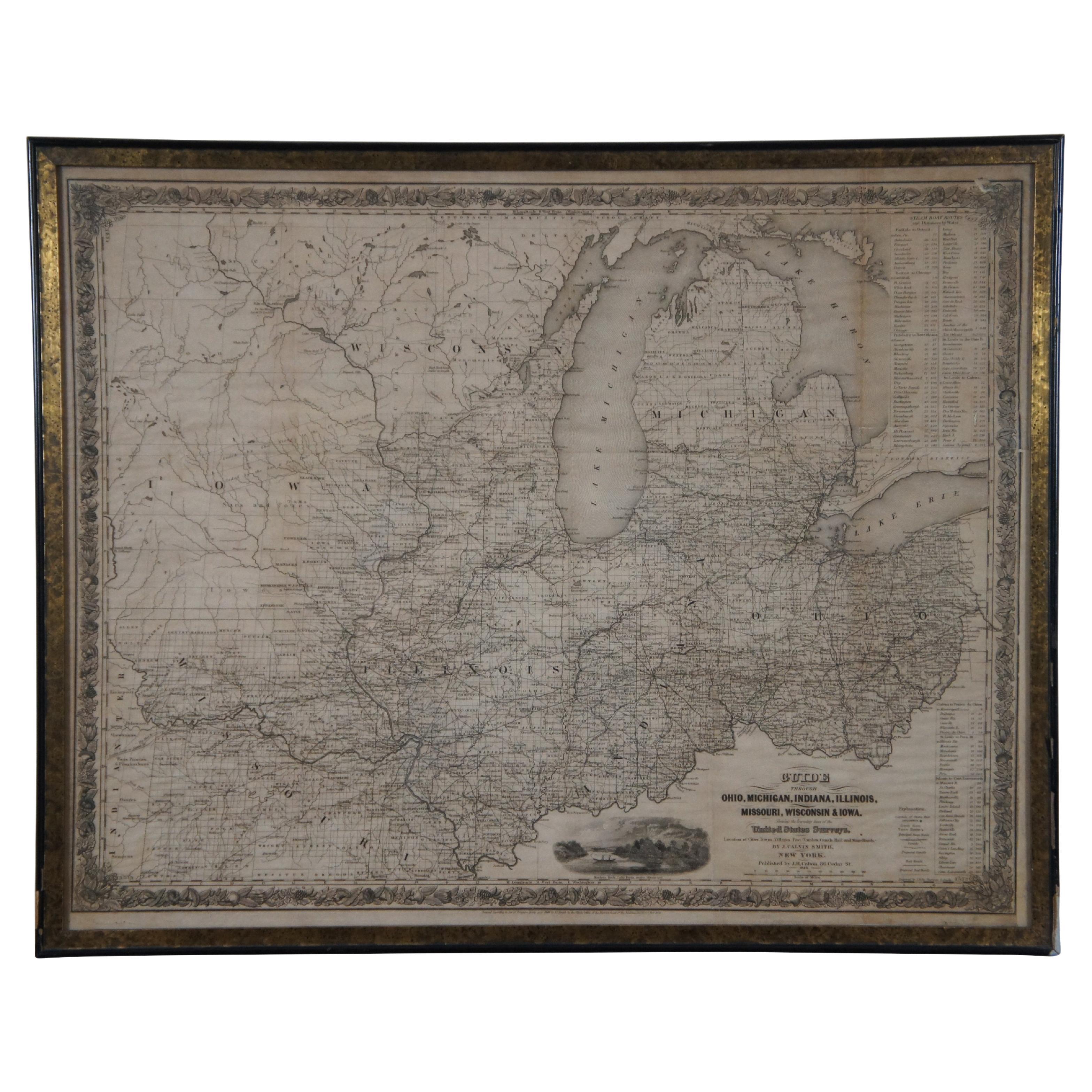
- Antique 1844 J Calvin Smith JH Colton Midwest United States Survey Map 27"By J.H. ColtonLocated in Dayton, OHAntique framed black and white map of seven Midwestern American states. Guide Through Ohio, Michigan, Indiana, Illinois, Missouri, Wisco...Category
Antique 1840s Maps
MaterialsPaper
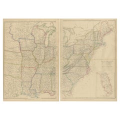
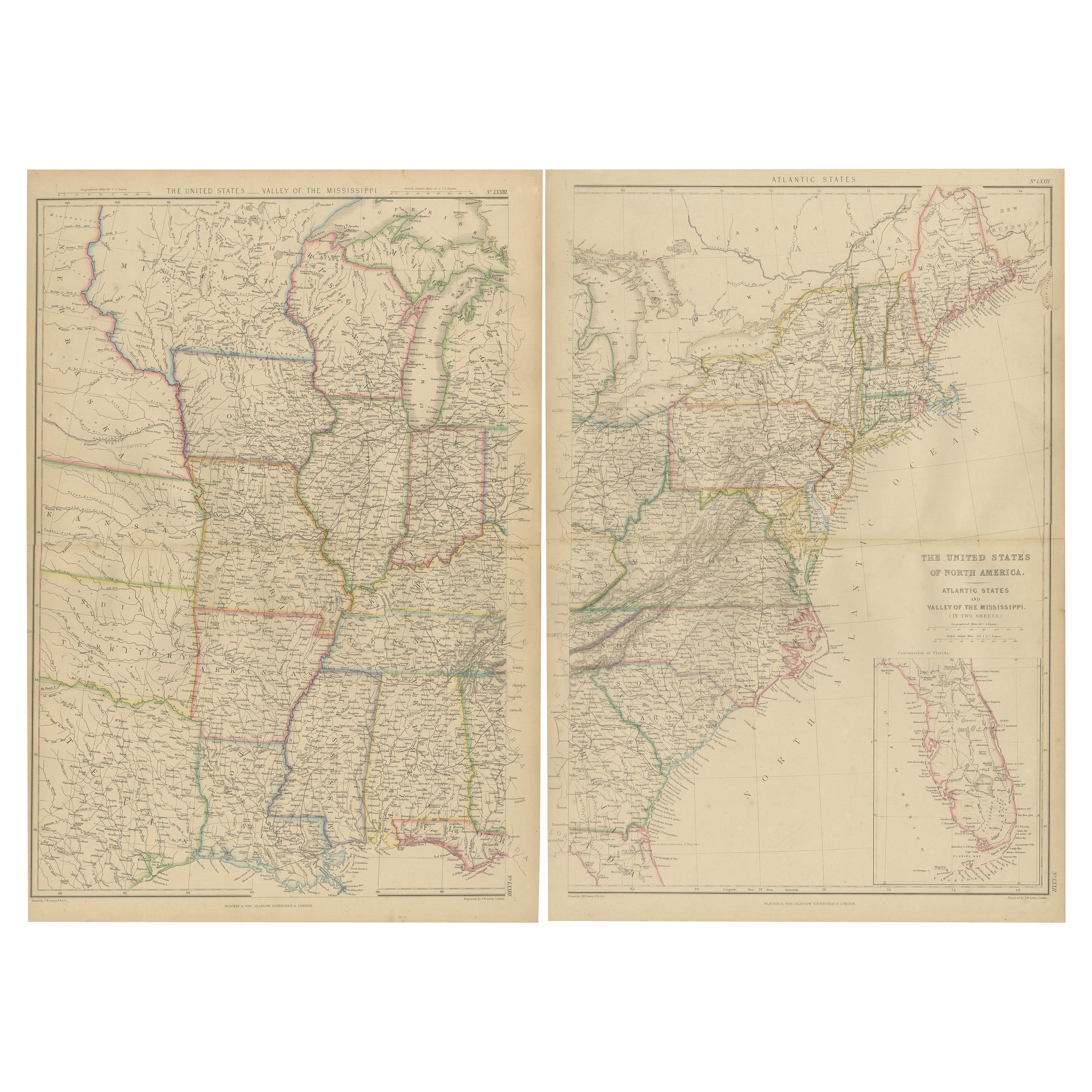
- Set of 2 Antique Maps of the United States by W. G. Blackie, 1859Located in Langweer, NLAntique map titled 'The United States of North America, Atlantic States and Valley of the Mississippi'. Original antique map of the United States of North America, Atlantic States an...Category
Antique Mid-19th Century Maps
MaterialsPaper
- Antique Map of The United States of North America, Pacific States, 1882Located in Langweer, NLThe map is from the same 1882 Blackie Atlas and focuses on the Pacific States of the United States of America during that period. Here are some details and historical context about t...Category
Antique 1880s Maps
MaterialsPaper
- Antique Map of the United States of America by Lapie '1842'Located in Langweer, NLAntique map titled 'Carte des États-Unis d'Amérique'. Map of the United States of America (USA). This map originates from 'Atlas universel...Category
Antique Mid-19th Century Maps
MaterialsPaper
- Small Map of the United StatesLocated in Langweer, NLAntique map titled 'Amérique septe. Physique'. Small map of the United States. lithographed by C. Callewaert brothers in Brussels circa 1870.Category
Antique Mid-19th Century Maps
MaterialsPaper