
J.H. Colton Furniture

to
3
3
1
3
3
2
2
3
3
3
1
12,528
3,602
2,602
2,296
Creator: J.H. Colton
1857 "Nebraska and Kanzas" Map Published by J. H. Colton

1857 "Nebraska and Kanzas" Map Published by J. H. Colton

By J.H. Colton

Located in Colorado Springs, CO

Presented is an original 1857 printing of J. H. Colton's map of Nebraska and Kansas. First published in 1855, this is a later 1857 printing, issued as page number 50 in Colton’s Atla...

Category

1850s American Victorian Antique J.H. Colton Furniture

Materials

Paper

Related Items
Small Map of the United States, circa 1870

Small Map of the United States, circa 1870

$88

H 6.82 in W 7.37 in D 0.02 in

Small Map of the United States, circa 1870

Located in Langweer, NL

Antique map titled 'Amérique septe. Physique'. Small map of the United States. lithographed by C. Callewaert brothers in Brussels circa 1870.

Category

Mid-19th Century Belgian Antique J.H. Colton Furniture

Materials

Paper

Antique Map of North America, Canada, United States and Mexico, 1860

Antique Map of North America, Canada, United States and Mexico, 1860

Located in Langweer, NL

Antique Map of North America, Canada, United States and Mexico, 1860 This impressive nineteenth-century map of North America was published by W. G. Blackie of Scotland around 1860 a...

Category

Mid-19th Century British Antique J.H. Colton Furniture

Materials

Paper

"The United States from the Latest Authorities" Antique Wall Map, 1835

"The United States from the Latest Authorities" Antique Wall Map, 1835

Located in Colorado Springs, CO

This is a 1835 map of “The United States from the Latest Authorities” by Ezra Strong. A hand-colored engraved wall map of the eastern half of the United States, this map has a large inset of the "Oregon District" and several engraved city views and two portraits. The primary map extends to Mexico Texas and the Missouri Territory, showing the course of the Missouri River to Ft. Mandan and Old Ft. Mandan, and noting many forts along the river. The territories to the east of Missouri Territory are separately delineated as Sioux District and Huron District. The western details of the map are very good for a map of this time period, with many Native American settlements, villages, forts and other details noted. The map is bordered with vignettes of Boston, New York, Philadelphia, Hartford, Cincinnati, and Baltimore. Each vignette notes the date settled, primary settler, and the population as of 1830. Two portraits of LaFayette and George Washington are presented in full length with related biographical information. A large inset map at lower right shows the Oregon District, centered on the Columbia River and extending to the Rocky Mountains. This is one of the earliest commercial appearances of a separate map of Oregon...

Category

1830s American Antique J.H. Colton Furniture

Materials

Paper

Vintage Framed United States Map

Vintage Framed United States Map

$2,550

H 23.5 in W 35.75 in D 0.5 in

Vintage Framed United States Map

Located in Queens, NY

Vintage aged paper map of the United States mounted on particle board and framed in a simple wooden frame.

Category

20th Century American Mid-Century Modern J.H. Colton Furniture

Materials

Wood, Paper

Antique Map of The United States of North America, 1882

Antique Map of The United States of North America, 1882

Located in Langweer, NL

This is a historical map titled "The United States of North America, Central Part" from the 1882 Blackie Atlas. It depicts the continental United States with a high level of detail, ...

Category

1880s British Antique J.H. Colton Furniture

Materials

Paper

Antique Northeastern United States Map — New England & Mid-Atlantic, Bonne, 1780

Antique Northeastern United States Map — New England & Mid-Atlantic, Bonne, 1780

Located in Langweer, NL

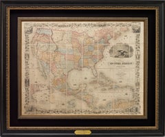
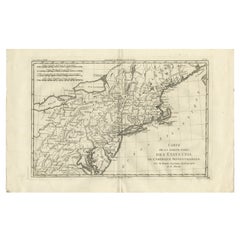
Antique Northeastern United States Map — New England & Mid-Atlantic, Bonne c.1780 This finely engraved eighteenth-century map by Rigobert Bonne presents a detailed depiction of the northern United States and adjacent regions of North America during the Enlightenment period. Engraved circa 1780, the map reflects Bonne’s influential role as Ingénieur-Hydrographe de la Marine and chief cartographer at the Dépôt de la Marine in Paris, where he succeeded Jacques-Nicolas Bellin and advanced a more scientific and systematic approach to cartography. Bonne’s work is recognized for its clarity, precision, and restrained aesthetic, marking a shift away from ornate decorative traditions toward geographic accuracy and legibility. 
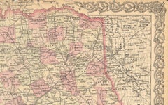
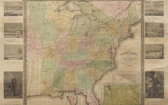
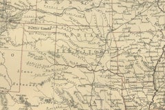
Titled “Carte de la Partie Nord, des États Unis de l’Amérique Septentrionale,” the composition captures the northeastern United States and surrounding territories, including New England, New York, Pennsylvania, New Jersey, and the Mid-Atlantic region, extending inland toward the Great Lakes and westward frontier territories. Prominent geographic features such as Lake Erie and Lake Ontario, the Hudson River, Long Island, and the Chesapeake Bay are carefully rendered, while numerous towns, settlements, and colonial boundaries reflect contemporary European understanding of the newly formed United States following the American Revolutionary period. The detailed coastal delineation underscores the importance of maritime navigation and trade along the Atlantic seaboard. Bonne’s restrained engraving style enhances both readability and visual elegance. Delicate hachuring suggests relief, while grid lines and refined typography emphasize the scientific structure characteristic of Enlightenment cartography. The balanced horizontal composition provides a comprehensive geographic overview, making the map historically informative while maintaining strong decorative appeal. Produced during a transformative moment in North American history, this map offers insight into European perspectives on the early United States and its evolving territorial identity. Today, Bonne’s maps are highly sought after by collectors for their historical significance, clean engraving style, and versatility as decorative wall pieces suitable for both traditional and contemporary interiors. Condition report: Good antique condition with age-related toning, visible central fold as issued, light scattered spotting, and minor handling wear consistent with eighteenth-century paper; margins remain suitable for framing. Framing tips: Particularly effective in a dark walnut or black frame with an ivory or warm off-white mat; the wide horizontal format works well above desks or consoles and pairs nicely with other Bonne maps for a cohesive historical display. Technique: Copperplate engraving Maker: Rigobert Bonne, France, circa 1780 Keyword block: United States antique map, New England antique map, Rigobert Bonne map, early USA cartography, Enlightenment era map America, Dépôt de la Marine map, Lake Erie Lake Ontario antique map, New York Pennsylvania antique...

Category

Late 18th Century French Antique J.H. Colton Furniture

Materials

Paper

Antique Map of the United States 'North West' by Johnston, '1909'

Antique Map of the United States 'North West' by Johnston, '1909'

$236Sale Price|20% Off

H 19.49 in W 24.41 in D 0.02 in

Antique Map of the United States 'North West' by Johnston, '1909'

Located in Langweer, NL

Antique map titled 'United States of North America'. Original antique map of the United States of North America ( North West ). This map originates from the ‘Royal Atlas of Modern Ge...

Category

Early 20th Century J.H. Colton Furniture

Materials

Paper

Antique Map of the Eastern United States with Inset Map of Texas

Antique Map of the Eastern United States with Inset Map of Texas

$511Sale Price|20% Off

H 14.65 in W 17.84 in D 0.02 in

Antique Map of the Eastern United States with Inset Map of Texas

Located in Langweer, NL

Antique map titled 'Verein-Staaten von Nord-America mit Ausnahme Florida's und der Westlichen Territorien'. This map extends as far west as Louisiana and only includes the northern p...

Category

Mid-19th Century Antique J.H. Colton Furniture

Materials

Paper

Antique Map of The United States Southern Section by A & C. Black, 1870

Antique Map of The United States Southern Section by A & C. Black, 1870

$236Sale Price|20% Off

H 17.52 in W 23.63 in D 0.02 in

Antique Map of The United States Southern Section by A & C. Black, 1870

Located in Langweer, NL

Antique map titled 'United States Southern Section'. Original antique map of Map of The United States Southern Section. This map originates from ‘Black's General Atlas of The World’....

Category

Late 19th Century Antique J.H. Colton Furniture

Materials

Paper

Antique Map of Colton's United States, Paper, Mid-19th Century, 1855

Antique Map of Colton's United States, Paper, Mid-19th Century, 1855

$843Sale Price|20% Off

H 17.45 in W 27.45 in D 0.02 in

Antique Map of Colton's United States, Paper, Mid-19th Century, 1855

Located in Langweer, NL

Antique map titled 'Colton's United States of America'. Show railroads, canals, state capitals, major cities and towns, military posts, historic trails, Pony Express and U.S. mail routes; Dakota [Territory] extending deep into Nebraska, and Idaho [Territory] encompassing [modern day] Montana and Wyoming; Indian Territory...

Category

Mid-19th Century Antique J.H. Colton Furniture

Materials

Paper

Previously Available Items
1855 "The United States of America" by J. H. Colton

1855 "The United States of America" by J. H. Colton

By J.H. Colton

Located in Colorado Springs, CO

This is an attractive 19th century map of the United States. Published in 1855 by Joseph H. Colton in New York, this map details the area from the southern border of Canada, labeled ...

Category

1850s American Victorian Antique J.H. Colton Furniture

Materials

Paper

Framed 19th Century Colton Map of Mexico, Texas, California and US Territories

Framed 19th Century Colton Map of Mexico, Texas, California and US Territories

By J.H. Colton

Located in Alamo, CA

This framed 19th century map of the southern portions of North America by J. H. Colton, published in New York in 1855 in his General Atlas of the World on page No. 54 in volume 1. Th...

Category

Mid-19th Century American Other Antique J.H. Colton Furniture

Materials

Paper

J.h. Colton furniture for sale on 1stDibs.

J.H. Colton furniture are available for sale on 1stDibs. These distinctive items are frequently made of paper and are designed with extraordinary care. There are many options to choose from in our collection of J.H. Colton furniture, although brown editions of this piece are particularly popular. If you’re looking for additional options, many customers also consider furniture by Sioux Indian Art, Barry Kieselstein-Cord, and Francesco Scavullo. Prices for J.H. Colton furniture can differ depending upon size, time period and other attributes — on 1stDibs, these items begin at $1,175 and can go as high as $13,500, while a piece like these, on average, fetch $7,338.