Items Similar to Ancient Gaul: A Cartographic Overview of Gallic Tribes and Roman Provinces, 1880
Want more images or videos?
Request additional images or videos from the seller
1 of 9
Ancient Gaul: A Cartographic Overview of Gallic Tribes and Roman Provinces, 1880
$356.19
$445.2420% Off
£263.71
£329.6320% Off
€296
€37020% Off
CA$493.17
CA$616.4620% Off
A$538.42
A$673.0320% Off
CHF 282.27
CHF 352.8420% Off
MX$6,539.37
MX$8,174.2220% Off
NOK 3,525.14
NOK 4,406.4320% Off
SEK 3,328.67
SEK 4,160.8420% Off
DKK 2,253.51
DKK 2,816.8920% Off
About the Item
The print titled "GALLIA," is a historical map of ancient Gaul, which corresponds to modern-day France and parts of its surrounding countries. Here are the features and details noted in the print:
1. **Regional Divisions**: The map is color-coded to delineate the various tribes or administrative divisions within Gaul during ancient times. The regions are probably labeled with the names they were known by during the Roman era.
2. **Topography**: It shows detailed physical features such as mountain ranges, including the Alps (notably marked as "ALPES COTTIAE, MARITIMAE, NARBONENSIS V. VIENNENSIS"), river systems like the Rhine and Rhône, and other geographic features of the landscape.
3. **Inset Maps**: The map includes inset maps focusing on specific areas:
- The top left inset is labeled "INSULA BATAVORUM," which likely depicts the Batavian Island area near the Rhine, inhabited by the Batavi tribe.
- The bottom left inset shows a detailed map of the alpine regions, possibly providing a closer look at the topography and settlements in these areas during Roman times.
4. **Cities and Settlements**: Symbols and labels indicate the locations of important cities, towns, and possibly Roman outposts or colonies. These locations may include significant Gallic settlements and Roman cities such as Lugdunum (Lyon) and Lutetia (Paris).
5. **Road Networks**: Lines may represent the Roman road network, which facilitated military, trade, and administrative connectivity across the vast province.
6. **Latin Labels**: Names and descriptions are provided in Latin, which was the lingua franca of the Roman Empire and commonly used in academic works of the 19th century.
7. **Bordering Territories**: The map also shows the adjacent regions and territories at the time, which could include parts of the Roman provinces Germania, Belgica, and others.
8. **Legend and Scale**: A legend is present, explaining the symbols and color codes used throughout the map, along with a scale for distance measurement.
This map would be an invaluable tool for historical and educational purposes, offering a snapshot of the geographical and political landscape of ancient Gaul during the Roman era. It is a testament to the cartographic and historical knowledge of the 19th century, reflecting the scholarly efforts to understand and visualize the past.
This map is intriguing for several reasons:
1. **Historical Coverage**: It represents ancient Gaul, a region that was crucial in the history of the Roman Empire and the subsequent formation of Europe. It provides a visual representation of the Roman province before the fall of the Roman Empire.
2. **Rich Detail**: The map includes detailed depictions of geographical features, settlements, and the extensive network of Roman roads, showcasing the advanced state of Roman surveying and infrastructure.
3. **Cultural Significance**: Gaul was the site of significant historical events, including the Gallic Wars led by Julius Caesar and the later cultural and political developments that laid the groundwork for the medieval kingdoms of Europe.
4. **Roman Influence**: The map illustrates the extent of Roman influence in Gaul, including the spread of Roman towns and the Romanization of indigenous Celtic tribes.
5. **Linguistic Heritage**: The use of Latin nomenclature reflects the linguistic heritage left by the Romans, many of which influence modern French and other Romance languages.
6. **Inset Maps**: The additional detailed maps of specific areas, such as the Batavian Island and the Alpine regions, offer a closer look at these important sub-regions within Gaul.
7. **Educational Value**: For historians, scholars, and enthusiasts of ancient history, this map serves as an educational resource for understanding the complexities of ancient Gaul and its integration into the Roman Empire.
The period depicted on the map is likely to be during the Roman occupation of Gaul, which lasted from the 1st century BC, following the Gallic Wars, until the fall of the Western Roman Empire in the 5th century AD. The precise period could be more specifically identified by analyzing the names of the tribes, the designation of the Roman provinces, and the status of the road networks shown on the map.
- Dimensions:Height: 15.56 in (39.5 cm)Width: 18.51 in (47 cm)Depth: 0 in (0.02 mm)
- Materials and Techniques:
- Period:
- Date of Manufacture:1880
- Condition:Good, given age. General age-related toning, especially around the edges. Vertical folding line as issued. Please study scan carefully.
- Seller Location:Langweer, NL
- Reference Number:Seller: BG-13686-2-111stDibs: LU3054338540252
About the Seller
5.0
Recognized Seller
These prestigious sellers are industry leaders and represent the highest echelon for item quality and design.
Platinum Seller
Premium sellers with a 4.7+ rating and 24-hour response times
Established in 2009
1stDibs seller since 2017
2,641 sales on 1stDibs
Typical response time: <1 hour
- ShippingRetrieving quote...Shipping from: Langweer, Netherlands
- Return Policy
Authenticity Guarantee
In the unlikely event there’s an issue with an item’s authenticity, contact us within 1 year for a full refund. DetailsMoney-Back Guarantee
If your item is not as described, is damaged in transit, or does not arrive, contact us within 7 days for a full refund. Details24-Hour Cancellation
You have a 24-hour grace period in which to reconsider your purchase, with no questions asked.Vetted Professional Sellers
Our world-class sellers must adhere to strict standards for service and quality, maintaining the integrity of our listings.Price-Match Guarantee
If you find that a seller listed the same item for a lower price elsewhere, we’ll match it.Trusted Global Delivery
Our best-in-class carrier network provides specialized shipping options worldwide, including custom delivery.More From This Seller
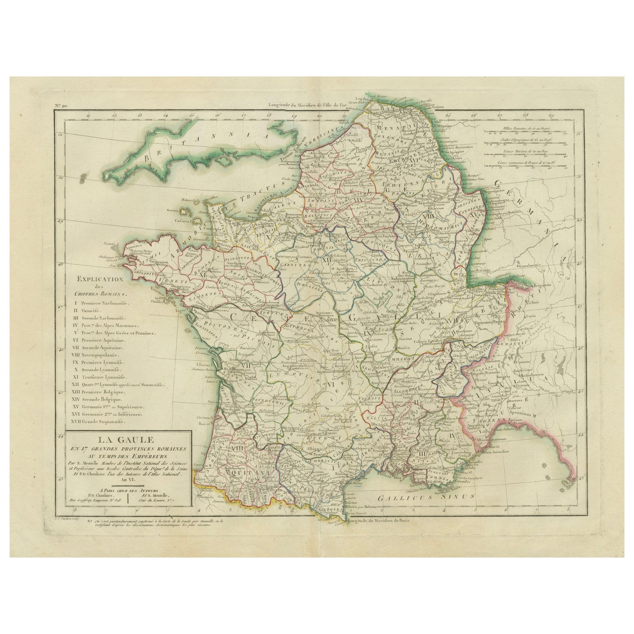
View AllMap of Ancient Gaul & Roman Provinces: Early 19th Century - 1802 Tardieu Atlas
Located in Langweer, NL
### Antique Map Description
**Title:** La Gaule et Ses Grandes Dignités Romaines au Temps des Empereurs
**Publication Details:**
- **Atlas Title:** Nouvel Atlas Universel de Géogra...
Category
Antique Early 1800s Maps
Materials
Paper
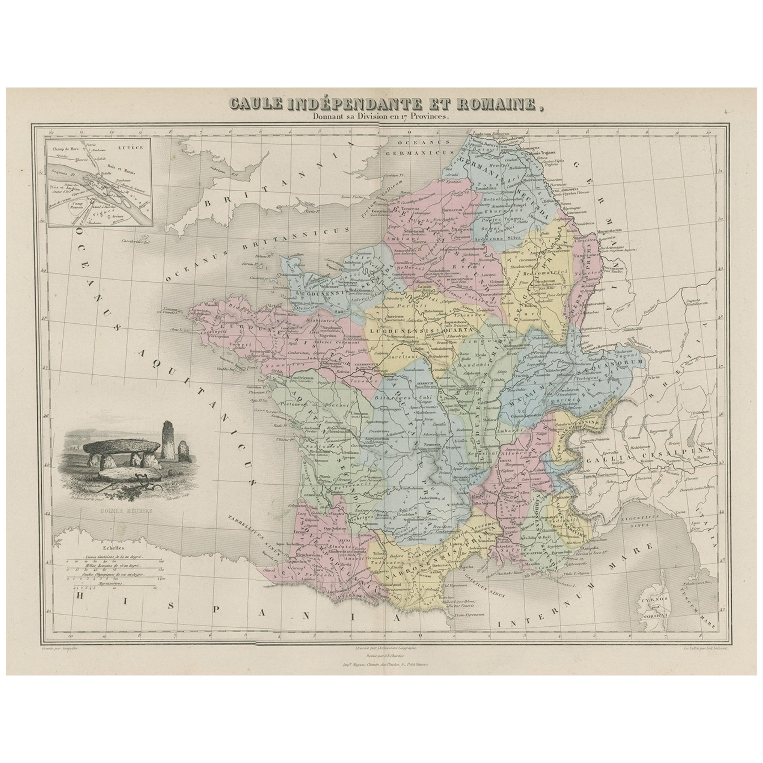
Antique Map of France in Ancient Roman Times, 1880
Located in Langweer, NL
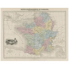
Antique map titled 'Gaule indépendante et Romaine'.
Old map of Gaul or France in ancient Roman times. The map covers from the southern part of England (Britannia) to the north of S...
Category
Antique 19th Century Maps
Materials
Paper
$182 Sale Price
20% Off
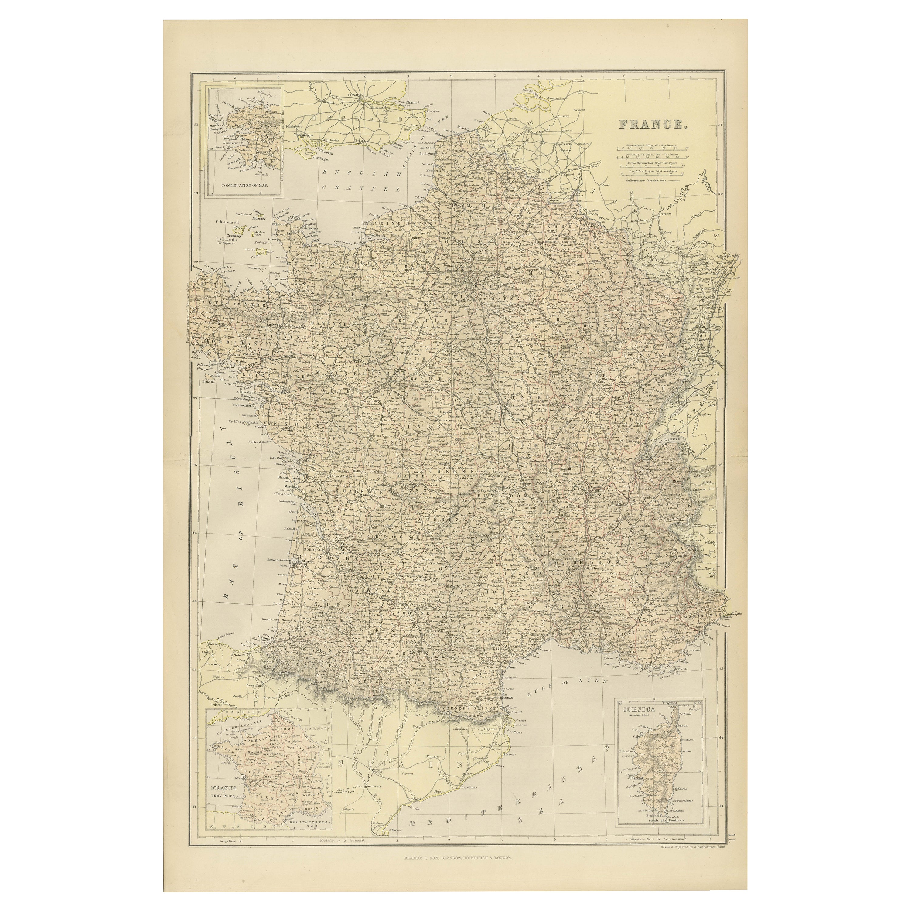
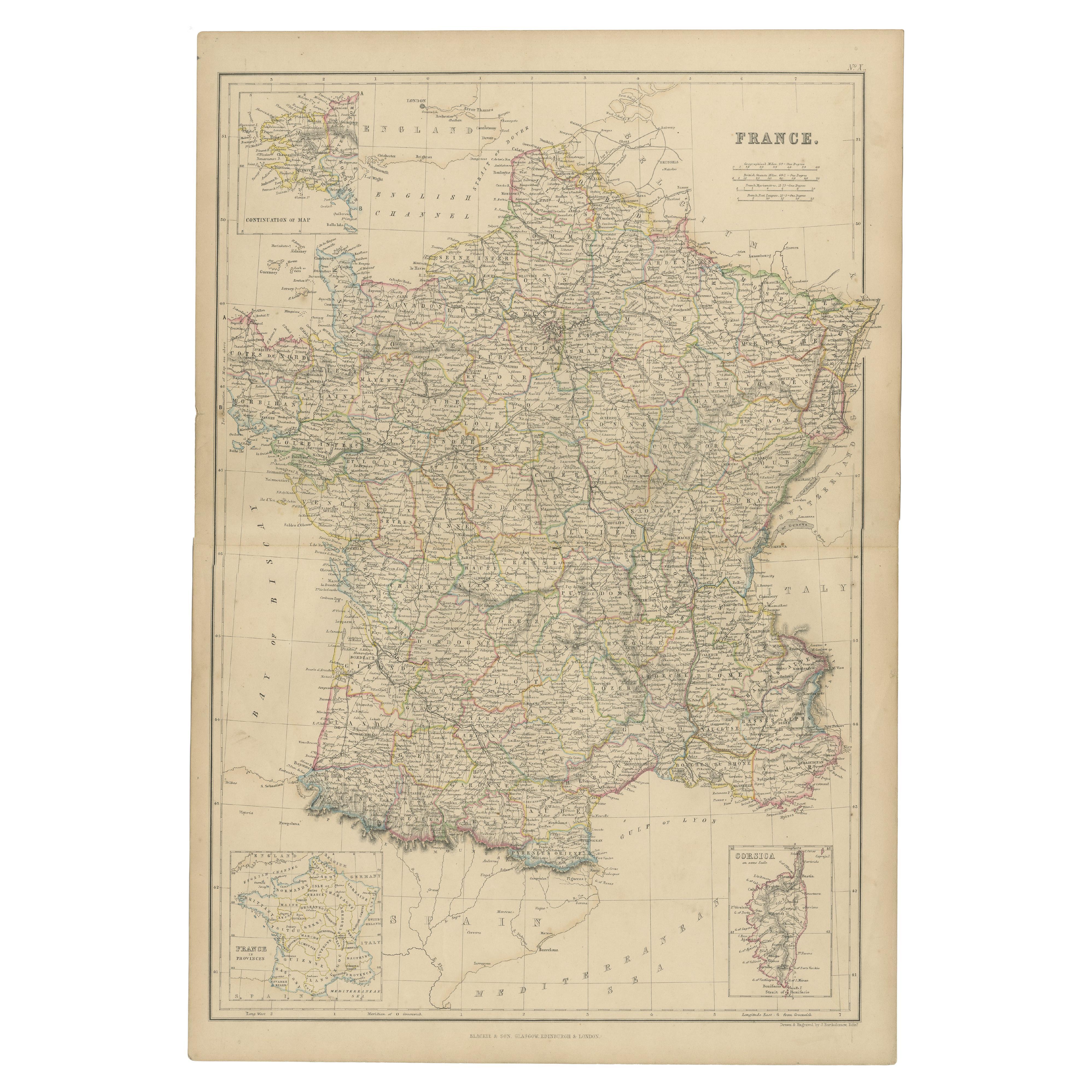
1882 Map of France Highlighting Political Boundaries, Cities, Insets of Corsica
Located in Langweer, NL
This 1882 map of France, published by Blackie and Son as part of the 'Comprehensive Atlas and Geography of the World,' offers a detailed depiction of the country during the late 19th...
Category
Antique 1880s Maps
Materials
Paper

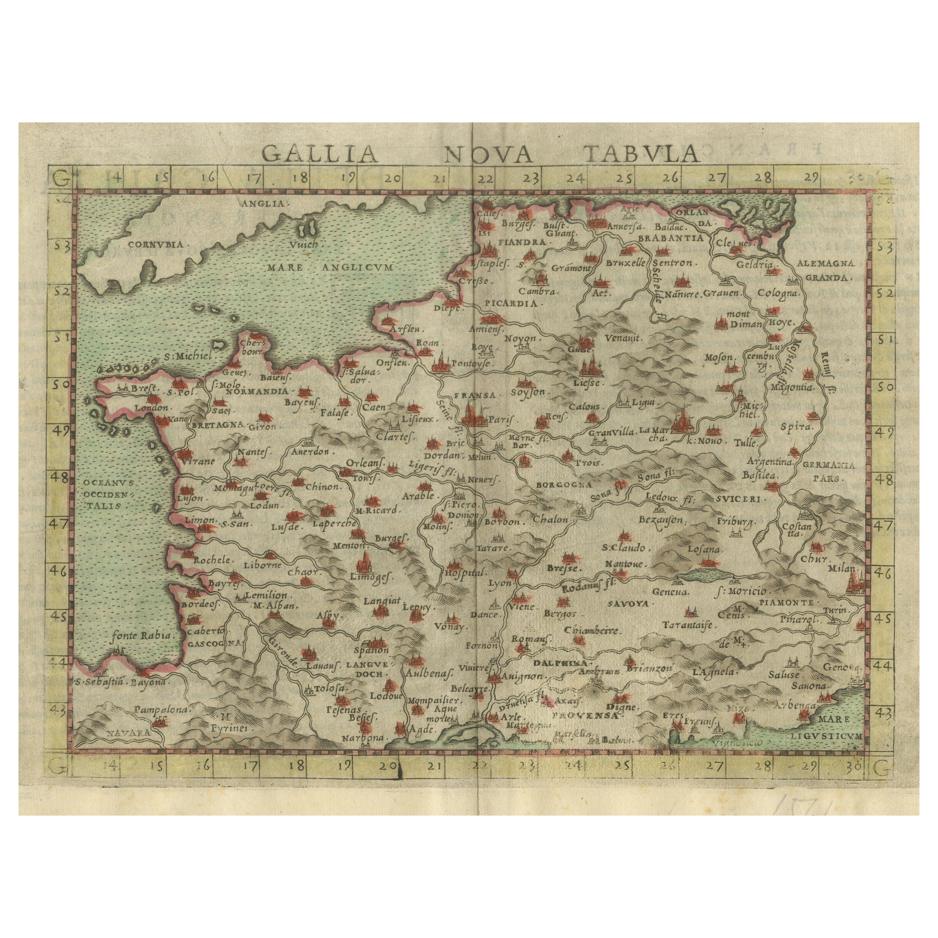
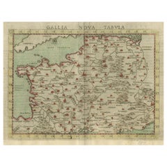
Antique Map of France, based on the work of Ptolemy
Located in Langweer, NL
Antique map titled 'Gallia Nova Tabula'. Ruscelli's map of France. This map originates from 'Espositione & introduttioni universali di Gir. Ruscelli sopra tutta la Geografia di Tolomeo (..)' published by Girolamo Ruscelli, 1561.
Girolamo Ruscelli (1500-1566) was a cartographer, humanist, and scholar from Tuscany. Ruscelli was a prominent writer and editor in his time, writing about a wide variety of topics including the works of Giovanni Boccaccio and Francesco Petrarch, Italian language, Italian poetry, medicine, alchemy, and militia. One of his most notable works was a translation of Ptolemy’s Geographia...
Category
Antique 16th Century Maps
Materials
Paper
$365 Sale Price
20% Off
1859 Classic Map of France: Blackie's Imperial Geographic Masterpiece
Located in Langweer, NL
The "Antique Map of France" from 'The Imperial Atlas of Modern Geography', published in 1859 by W. G. Blackie, is a historically valuable cartographic work that offers a comprehensiv...
Category
Antique Mid-19th Century Maps
Materials
Paper

$225 Sale Price
25% Off
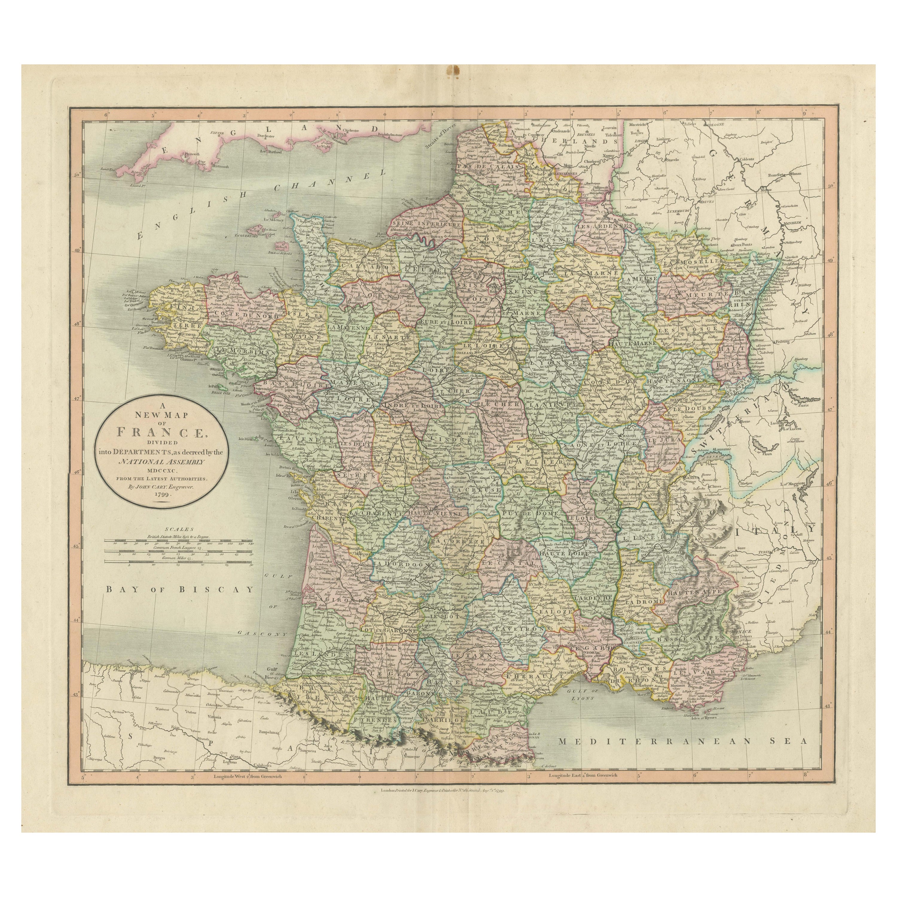
Antique Map of France Divided into Departments, with Original Hand Coloring
Located in Langweer, NL
Antique map titled 'A New Map of France (..)'. Original old map of France, divided into departments. With original/contemporary hand coloring. Published by John Cary, 1799. John Cary was an important and prolific London map seller...
Category
Antique Late 18th Century Maps
Materials
Paper
$423 Sale Price
20% Off
You May Also Like
France, Northern Part. Century Atlas antique map
Located in Melbourne, Victoria
'The Century Atlas. France, Northern Part.'
Original antique map, 1903.
Inset maps of 'France in Provinces' and 'Paris and Vicinity'.
Central fold as issued. Map name and number pr...
Category
Early 20th Century Victorian More Prints
Materials
Lithograph

Ancient National Atlas of France with Marengo
Located in Alessandria, Piemonte
Ancient National Atlas of France with the department of Marengo: a rare French etching dated 1806.
ST/178.
Category
Antique Early 19th Century French Other Prints
Materials
Paper

Large 19th Century Map of France
Located in Pease pottage, West Sussex
Large 19th Century Map of France.
Remarkable condition, with a pleasing age worn patina.
Recently framed.
France Circa 1874.
Category
Antique Late 19th Century French Maps
Materials
Linen, Paper

Antique Map of France
Located in Dallas, TX
Nice antique map of France in wood frame. This would make a great gift for a collector. A wonderful accessory!
Category
Early 20th Century Decorative Art
Materials
Glass, Wood, Paper

$1,760
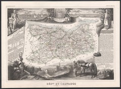
Calvados, France. Antique map of a French department, 1856
By Victor Levasseur
Located in Melbourne, Victoria
'Dept. du Calvados', steel engraving with original outline hand-colouring., 1856, from Levasseur's 'Atlas National Illustre'.
This area of France is known for its production of Cal...
Category
19th Century Naturalistic Landscape Prints
Materials
Engraving
Antique Colored Belgium Map Flandria Gallica Flanders Henricus Hondius
Located in Dayton, OH
Antique hand colored map of Flanders, Belgium, engraved by Henricus Hondius.
Sans frame - 21.25” x 18”.
Category
Antique 19th Century Renaissance Maps
Materials
Paper

$280 Sale Price
20% Off
More Ways To Browse
Antique Gallia
19th Century Round Dining Table
Carved Chinese Tables
Mid Century Modern Danish Teak Dining Tables
Long Rug Runners
Pair Arm Chairs
Sterling Silver Dinner Sets
United Chair Company
British Antiques
Italian Beech Chairs
Shirvan Rugs
Spain Marble
Vintage Brown Bottles
Vintage Danish Tables And Chairs
1960s Glass Top Coffee Table
Black Glass Coffee Tables
Burnt Wood
Mid Century Wrought Iron Chairs