Items Similar to Antique 1830 Map of Ulster, Ireland with Armagh, Down, Antrim, Donegal, Tyrone


Want more images or videos?
Request additional images or videos from the seller
1 of 8
Antique 1830 Map of Ulster, Ireland with Armagh, Down, Antrim, Donegal, Tyrone
$407.37
£303.20
€340
CA$557.99
A$620.61
CHF 324.06
MX$7,552.17
NOK 4,138.79
SEK 3,881.45
DKK 2,588.30
Shipping
Retrieving quote...The 1stDibs Promise:
Authenticity Guarantee,
Money-Back Guarantee,
24-Hour Cancellation
About the Item
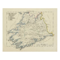
Title: Antique 1830 Map of Ulster, Ireland with Armagh, Down, Antrim, Donegal, and Tyrone
Description: This 1830 German-language map, titled Britisches Reich – C. Kon: Ireland, focuses on the province of Ulster in northern Ireland, highlighting the counties of Armagh, Down, Antrim, Londonderry, Donegal, Tyrone, Fermanagh, Monaghan, and Cavan. The map was published in Leipzig by Georg Joachim Goschen as part of the Atlas von Europa nebst den Kolonien, designed for businesspeople, newspaper readers, and owners of the Conversations-Lexicon. It was lithographed by O. Hermann and edited by W. E. A. von Schlieben.
The counties are outlined in hand-applied color, with major towns, roads, and natural features such as rivers and coastlines meticulously detailed. The Atlantic Ocean, Irish Sea, and North Channel are labeled, along with prominent cities such as Londonderry, Belfast, and Armagh. This map reflects the high level of precision characteristic of early 19th-century German cartography.
Condition Report:
Paper Quality: 19th-century laid paper with natural toning.
Engraving: Crisp lithographic print with sharp details.
Coloring: Original hand-applied outline coloring, well-preserved.
Margins: Wide margins with light foxing and minor discoloration.
Overall Condition: Very good, with no significant tears or defects.
Framing Tips:
Matting: Use an acid-free off-white mat to highlight the map’s aged character.
Glass: Museum-grade UV-protective glass to prevent fading.
Frame Style: A simple dark wood or gilt frame complements its antique style.
Mounting: Archival backing for long-term preservation.
This is a fine example of German-published 19th-century cartography, ideal for collectors of Irish and European maps.
- Dimensions:Height: 10.44 in (26.5 cm)Width: 12.88 in (32.7 cm)Depth: 0.01 in (0.2 mm)
- Materials and Techniques:Paper,Engraved
- Period:
- Date of Manufacture:1830
- Condition:Overall Condition: Very good, with no significant tears or defects. Wide margins with some foxing spots and minor discoloration.
- Seller Location:Langweer, NL
- Reference Number:Seller: BG-13711-81stDibs: LU3054343840602
About the Seller
5.0
Recognized Seller
These prestigious sellers are industry leaders and represent the highest echelon for item quality and design.
Platinum Seller
Premium sellers with a 4.7+ rating and 24-hour response times
Established in 2009
1stDibs seller since 2017
2,508 sales on 1stDibs
Typical response time: <1 hour
- ShippingRetrieving quote...Shipping from: Langweer, Netherlands
- Return Policy
Authenticity Guarantee
In the unlikely event there’s an issue with an item’s authenticity, contact us within 1 year for a full refund. DetailsMoney-Back Guarantee
If your item is not as described, is damaged in transit, or does not arrive, contact us within 7 days for a full refund. Details24-Hour Cancellation
You have a 24-hour grace period in which to reconsider your purchase, with no questions asked.Vetted Professional Sellers
Our world-class sellers must adhere to strict standards for service and quality, maintaining the integrity of our listings.Price-Match Guarantee
If you find that a seller listed the same item for a lower price elsewhere, we’ll match it.Trusted Global Delivery
Our best-in-class carrier network provides specialized shipping options worldwide, including custom delivery.More From This Seller
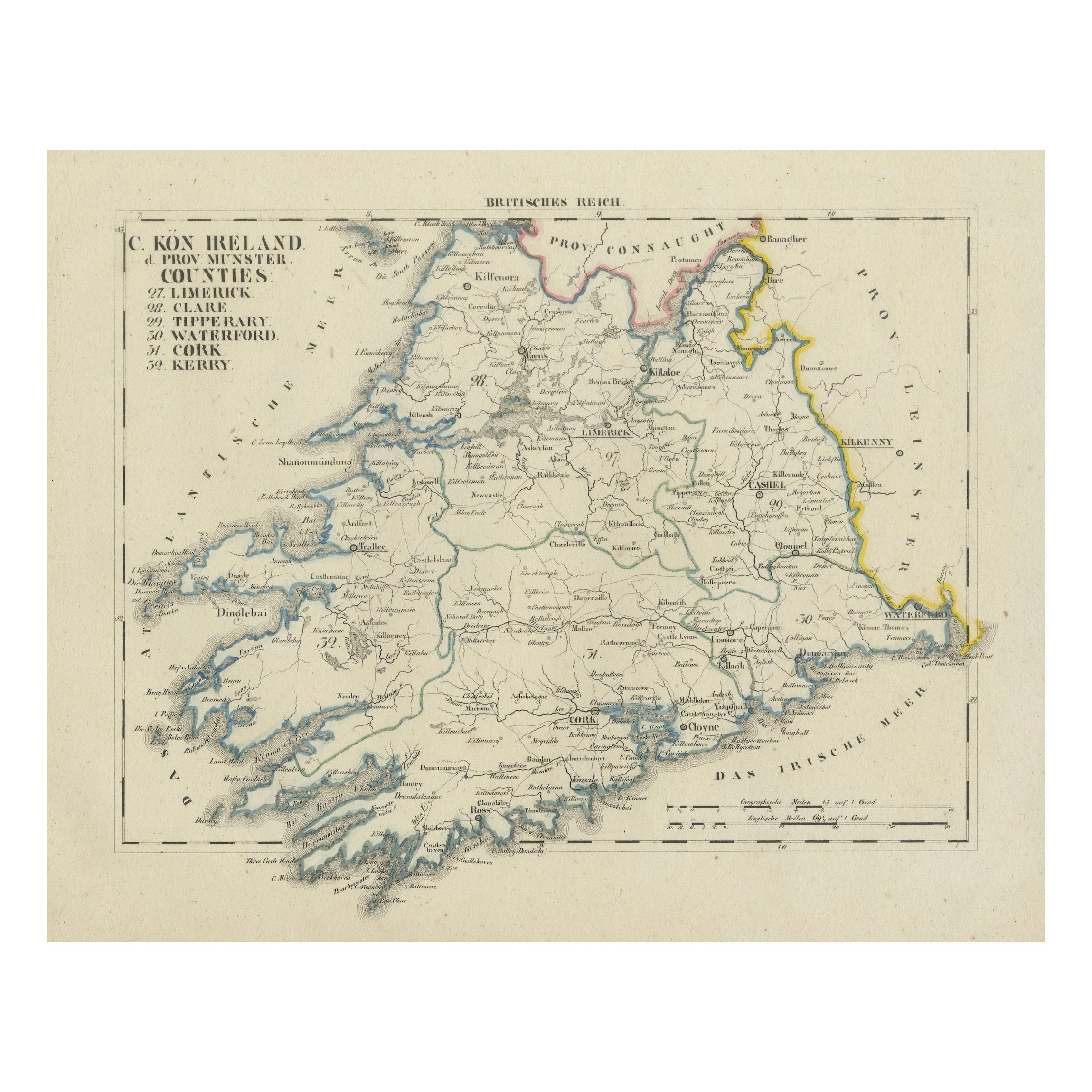
View AllAntique 1830 Map of Munster, Ireland with Limerick, Cork, Kerry and Tipperary
Located in Langweer, NL
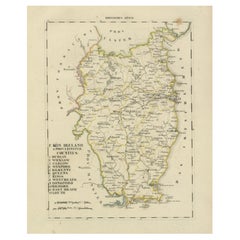
Title: Antique 1830 Map of Munster, Ireland with Limerick, Cork, Kerry, and Tipperary
Description: This 1830 German-language map, titled Britisches Reich – C. Kon: Ireland, focu...
Category
Antique 1830s Maps
Materials
Paper
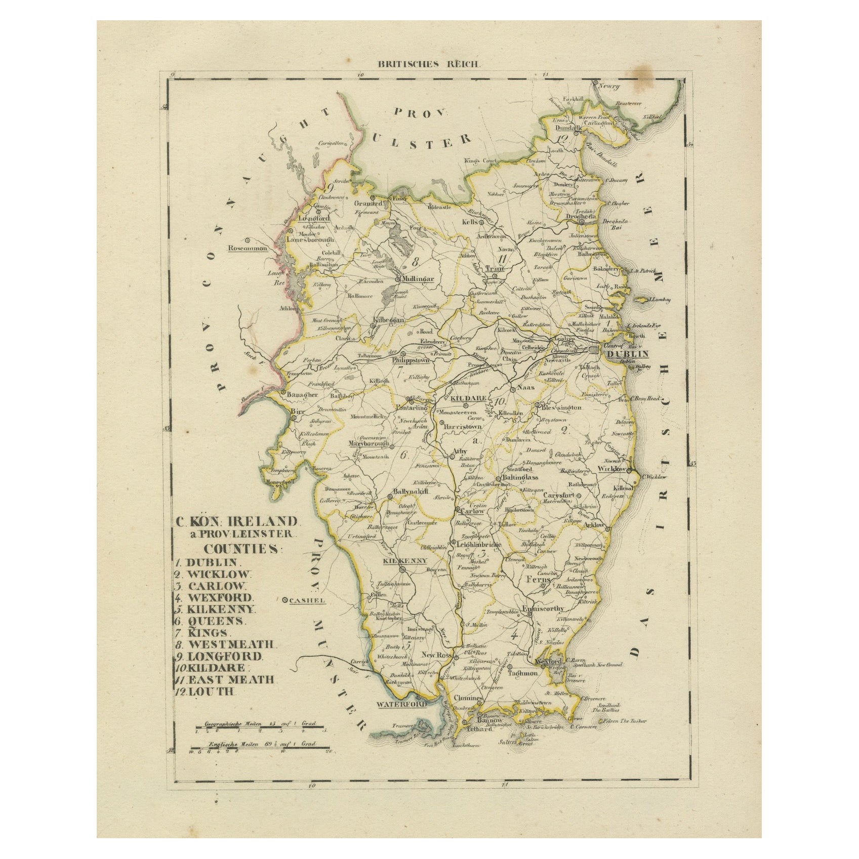
Antique 1830 Map of Leinster, Ireland with Dublin, Kilkenny, Wexford and Kildare
Located in Langweer, NL
Title: Antique 1830 Map of Leinster, Ireland with Dublin, Kilkenny, Wexford, and Kildare
Description: This 1830 German-language map, titled Britisches Reich – C. Kon: Ireland, f...
Category
Antique 1830s Maps
Materials
Paper
Map of Ireland: Early 19th Century - from the 1802 Tardieu Atlas
Located in Langweer, NL
Antique Map Description
**Title:** Carte d'Irlande
**Publication Details:**
- **Atlas Title:** Nouvel Atlas Universel de Géographie Ancienne et Moderne
- **Purpose:** For the Nouve...
Category
Antique Early 1800s Maps
Materials
Paper

$421 Sale Price
20% Off
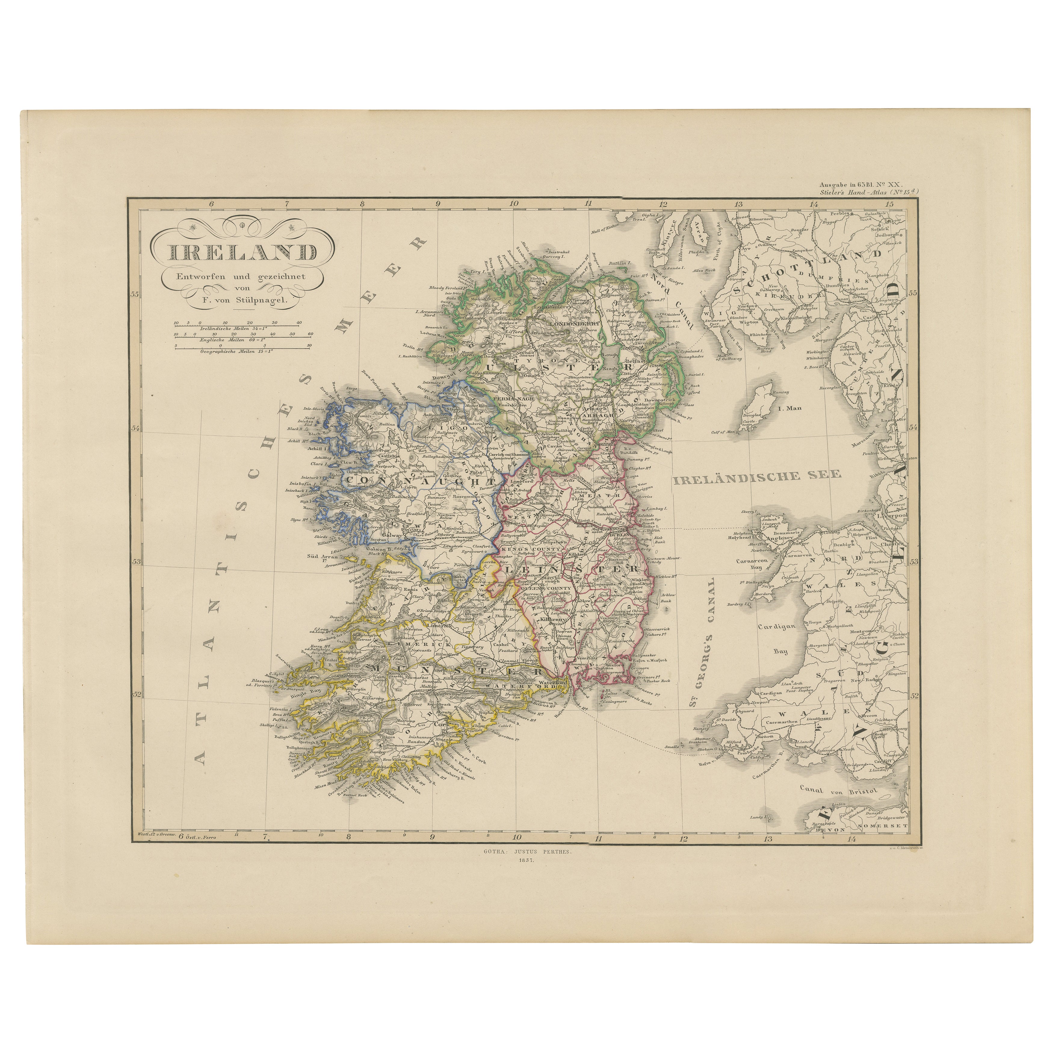
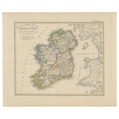
Ireland Map – Provincial and County Divisions 1851
Located in Langweer, NL
Ireland Map – Provincial and County Divisions 1851
This fine antique print shows Ireland titled simply “Ireland,” published in 1851 by Justus Perthes in Gotha as part of Adolf Stiel...
Category
Antique Mid-19th Century German Maps
Materials
Paper
Antique Map of Ireland, 1903, with Intricate County Boundaries & Coastal Details
Located in Langweer, NL
Title: Antique Map of Ireland, 1903, with Intricate County Boundaries and Coastal Detail
Description:
This antique map of Ireland, engraved and published in 1903 by the esteemed W. ...
Category
Early 20th Century Maps
Materials
Paper

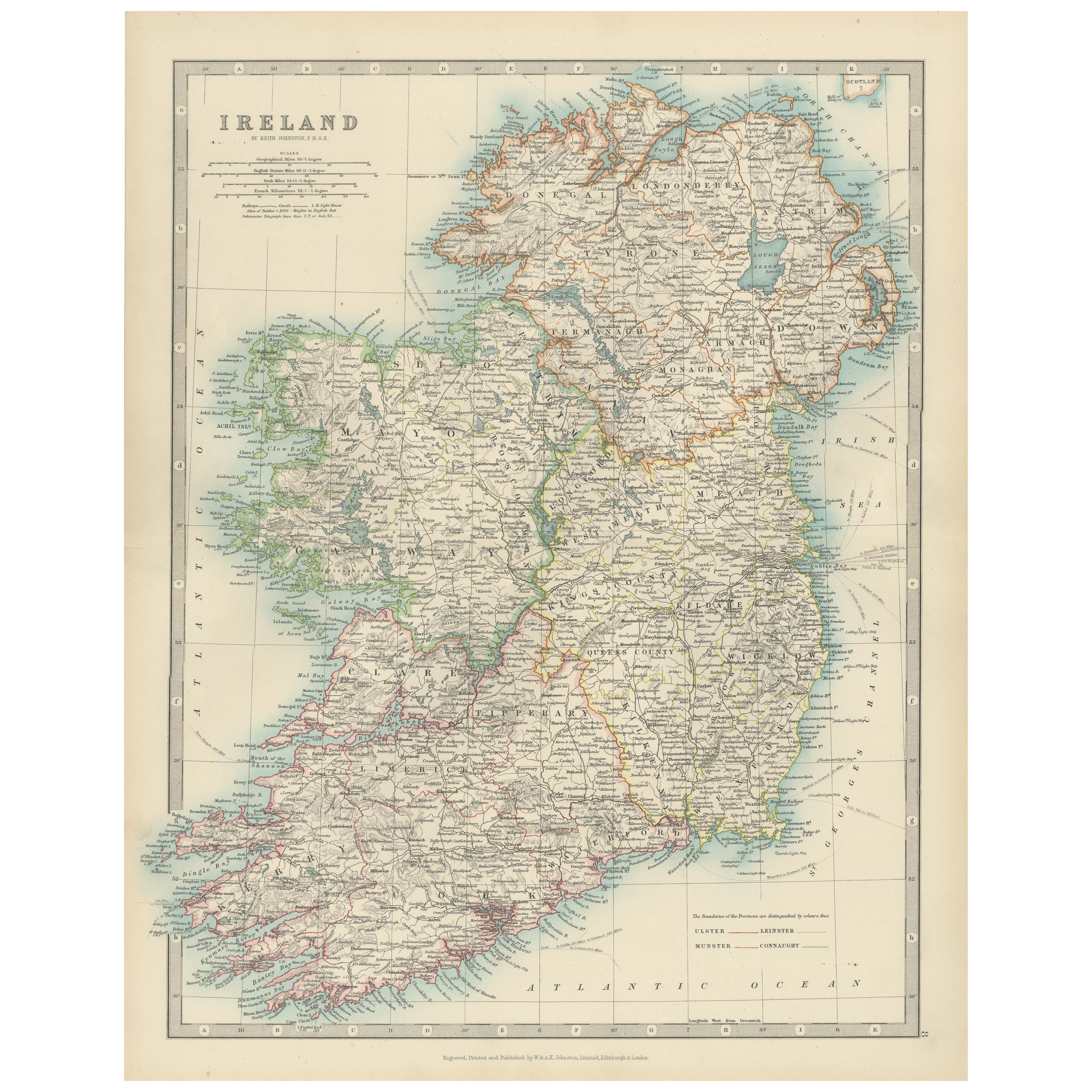
Antique Map of the United Kingdom and Ireland, 1852
Located in Langweer, NL
Antique map titled 'Groot-Brittanje en Ierland'. Map of the United Kingdom and Ireland. This map originates from 'School-Atlas van alle deelen der Aarde' by Otto Petri.
Artists a...
Category
Antique 19th Century Maps
Materials
Paper

$124 Sale Price
20% Off
You May Also Like
Large Original Antique Map of Ireland. C.1900
Located in St Annes, Lancashire
Fabulous map of Ireland
Original color.
Engraved and printed by the George F. Cram Company, Indianapolis.
Published, C.1900.
Unframed.
Free shipping.
Category
Antique 1890s American Maps
Materials
Paper

Original Antique Map of Ireland- Kerry. C.1840
Located in St Annes, Lancashire
Great map of Kerry
Steel engraving
Drawn under the direction of A.Adlard
Published by How and Parsons, C.1840
Unframed.
Category
Antique 1840s English Maps
Materials
Paper

Original Antique Map of Ireland- Tipperary and Waterford. C.1840
Located in St Annes, Lancashire
Great map of Tipperary and Waterford
Steel engraving
Drawn under the direction of A.Adlard
Published by How and Parsons, C.1840
Unframed.
Category
Antique 1840s English Maps
Materials
Paper

England, Scotland & Ireland: A Hand Colored Map of Great Britain by Tirion
By Isaak Tirion
Located in Alamo, CA
This is a hand-colored double page copperplate map of Great Britain entitled "Nieuwe Kaart van de Eilanden van Groot Brittannien Behelzende de Kon...
Category
Antique Mid-18th Century Dutch Maps
Materials
Paper

Southeastern Ireland: A 17th Century Hand Colored Map by Mercator and Hondius
By Gerard Mercator
Located in Alamo, CA
A 17th century copperplate hand-colored map entitled "The Second Table of Ireland, Udrone" by Gerard Mercator and Jodocus Hondius, published in Amsterdam in 1635 in 'Cosmographicall ...
Category
Antique Mid-17th Century Dutch Maps
Materials
Paper

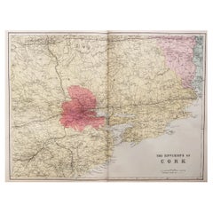
Large Original Antique Map of the Environs of Cork, Ireland, circa 1880
Located in St Annes, Lancashire
Great map of The Environs of Cork
Published circa 1880
Unframed
Free shipping.
Category
Antique 1880s Scottish Maps
Materials
Paper
More Ways To Browse
Northern Ireland
Irish Donegal
Antique Furniture Northern Ireland
Used Furniture Belfast
Vintage Scandanavian Chairs
19th Century Red Glass
Antique French Console Table Tables
Silver Bowl Large
Antique French Silk
Down Couch
Used Lighter Art
Blue Edge Glass
Mahogany 1950s Furniture
Solid Mahogany Table
Dessert Glasses
Geometric Glass Table
Mid Century Pin
6x10 Rug