Items Similar to Southeastern Ireland: A 17th Century Hand Colored Map by Mercator and Hondius


Want more images or videos?
Request additional images or videos from the seller
1 of 8
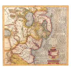
Southeastern Ireland: A 17th Century Hand Colored Map by Mercator and Hondius
About the Item
A 17th century copperplate hand-colored map entitled "The Second Table of Ireland, Udrone" by Gerard Mercator and Jodocus Hondius, published in Amsterdam in 1635 in 'Cosmographicall Description of the Fabricke & Figure of the World with new Mappes and Tables; By the studious industry of Jodocus Hondy', the first English edition of their 'Atlas Minor'. It is focused on a region of Ireland depicting present day County Carlow in Leinster Province and the city of Catherlaugh, which is now the city of Carlow. This region has an interesting history which led to Mercator producing a map focused on it. When Queen Elizabeth I forced Earl of Desmond, Gerald Fitzgerald, to renounce all his rights to family lands in Munster, Peter Carew claimed much of these land holdings in Ireland. Carew made his case to the English at Dublin Castle and was awarded title to the Barony of Udrone. He subsequently claimed title to one half the Kingdom of Cork, as well as other Irish lands.
The map is embellished with a strap work cartouche containing the name of the region. The map is beautifully hand colored with wide margins. It is presented in an archival cream colored mat measuring 14' wide x 12" high and the map sheet measures 11.25" wide x 7" high. There is English text on the verso. The map is in excellent condition.
Gerard Mercator (1512-1594) is one of the most famous cartographers of all time. He was born in Flanders and moved to Duisburg from Leuven in the Netherlands, where he lived and worked for the rest of his life. In addition to producing important maps and globes, he invented a projection on maps that presented all parallels and meridians at right angles to each other, with the distance between the parallels extending towards the poles, allowing accurate latitude and longitude calculation and navigational routes to be drawn using straight lines. This was an important technological advance for navigation at sea, as this allowed seafarers to plot their course without having to adjust their course based on frequent compass readings. This has become known as Mercator projection on maps produced by subsequent cartographers to this day. He is also the first to use the term “atlas”, which was first used to describe his collection of maps gathered in one volume. The Mercator atlas was published in 1595, a year after Mercator’s death by his heirs.
Jodocus Hondius (1563-1612) was a prominent globe maker and map engraver from Ghent (Flanders). After spending some time in London, he established his business in Amsterdam in 1593. Hondius bought the plates of Gerard Mercator in 1604 and added around 40 of his own maps in an atlas that he first published in 1606, preserving Mercator's name. After his death in 1612 in Amsterdam, the business was continued by his sons Jodocus II and Henricus, who published the English edition of the Mercator and Hondius Atlas Minor in 1635 that contained this map.
- Creator:Gerard Mercator (Artist)
- Dimensions:Height: 12 in (30.48 cm)Width: 14 in (35.56 cm)Depth: 0.13 in (3.31 mm)
- Materials and Techniques:Paper,Engraved
- Place of Origin:
- Period:Mid-17th Century
- Date of Manufacture:1635
- Condition:Wear consistent with age and use.
- Seller Location:Alamo, CA
- Reference Number:
Gerard Mercator
Gerard Mercator (1512-1594) was one of the most famous cartographers of the 16th century and, in fact, of all time. Mercator was known for his strict adherence to scientific methods of the day. He was responsible for advancing the technology of map making. For example his method of representing land masses in a cylindrical projection with north up and south down, first described in 1569, became the standard map projection for navigation. It is still referred to as The Mercator projection.
About the Seller
5.0
Vetted Seller
These experienced sellers undergo a comprehensive evaluation by our team of in-house experts.
1stDibs seller since 2020
12 sales on 1stDibs
- ShippingRetrieving quote...Ships From: Alamo, CA
- Return PolicyA return for this item may be initiated within 7 days of delivery.
More From This SellerView All
- 17th Century Hand-Colored Map of Southeastern England by Mercator and HondiusBy Gerard MercatorLocated in Alamo, CAA 17th century copperplate hand-colored map entitled "The Sixt Table of England" by Gerard Mercator and Jodocus Hondius, published in Amsterdam in 1635 in 'Cosmographicall Descriptio...Category
Antique Mid-17th Century Dutch Maps
MaterialsPaper
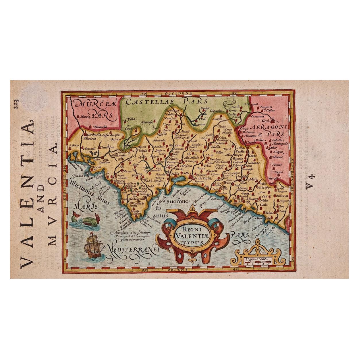
- 17th Century Hand-Colored Map of Valencia and Murcia, Spain by Mercator/HondiusBy Gerard MercatorLocated in Alamo, CAA 17th century hand-colored map entitled "Regni Valentiae Typus, Valentia and Murcia" by Gerard Mercator and Joducus Hondius, published in Amsterdam in 1635 in 'Cosmographicall Descr...Category
Antique Mid-17th Century Dutch Maps
MaterialsPaper
- Northern Scotland: A 17th Century Hand-colored Map by MercatorBy Gerard MercatorLocated in Alamo, CAThis is a framed hand-colored 17th century map of Northern Scotland by Gerard Mercator entitled "Scotiae pars Septentrionalis", published in Amsterdam in 1636. It is a highly detailed map of the northern part of Scotland, with the northwest Highlands and the cities Inverness and Aberdeen, as well as the Orkney Islands and the Hebrides. There is a decorative title cartouche in the upper left corner. The map is presented in an antiqued brown wood...Category
Antique 1630s Dutch Maps
MaterialsPaper
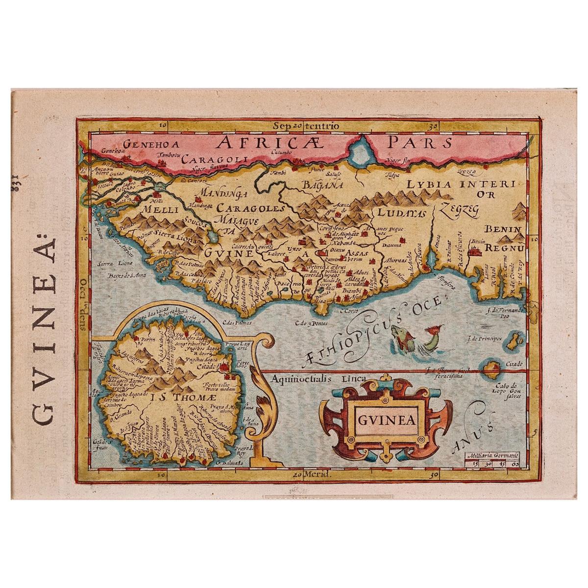
- 17th Century Hand-Colored Map of West Africa by Mercator/HondiusLocated in Alamo, CAA 17th century hand-colored map entitled "Guineae Nova Descriptio" by Gerard Mercator and Jodocus Hondius, published in their 'Atlas Minor' in Amsterdam in 1635. It is focused on the...Category
Antique Mid-17th Century Dutch Maps
MaterialsPaper
- Northern Scotland: A 16th Century Hand-colored Map by MercatorBy Gerard MercatorLocated in Alamo, CAA framed hand-colored 16th century map of Northern Scotland by Gerard Mercator entitled "Scotiae pars Septentrionalis", published in Amsterdam in 1636. It is a highly detailed map of the northern part of Scotland, with the northwest Highlands and the cities Inverness and Aberdeen, as well as the Orkney Islands and the Hebrides. There is a decorative title cartouche in the upper left corner. The map is presented in an antiqued brown wood...Category
Antique 16th Century Dutch Maps
MaterialsPaper
- "Africa Vetus": a 17th Century Hand-Colored Map by SansonBy Nicolas SansonLocated in Alamo, CAThis original hand-colored copperplate engraved map of Africa entitled "Africa Vetus, Nicolai Sanson Christianiss Galliar Regis Geographi" was originally created by Nicholas Sanson d...Category
Antique Late 17th Century French Maps
MaterialsPaper


You May Also Like
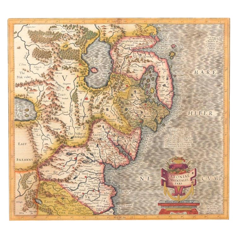
- Antique Map of Northern Ireland by Mercator/Hondius, Early 1600'sLocated in Langweer, NLAntique map titled 'Ultoniae Orientalis Pars'. Original antique map of Northern Ireland. Published by Mercator/Hondius, ca. 1600. Superb early map of the eastern part of Ulster, featuring Down and Antrim Counties in Northern Ireland. Mercator's famous moire pattern in the sea is used. Strong topographical features in the interior and ornamented with a title cartouche incorporating the distance scale. This was one of five Irish maps...Category
Antique 16th Century Maps
MaterialsPaper
- Antique Map of England by Mercator/Hondius, circa 1600Located in Langweer, NLAntique map titled 'Westmorlandia, Lancastria, Caernvan, Denbigh, Flint, Merionidh, Dalopia cum issulis Mania et Anglesey'. Original antique map of England...Category
Antique 16th Century Maps
MaterialsPaper
- Antique Map of Westfalia, Germany by Mercator/Hondius, circa '1620'Located in Langweer, NLAntique map titled 'Westfalia cum dioecelsi Bremensi'. Original antique map of Germany. Published by Mercator/Hondius, circa '1620' 17th Century antique detailled map of Westphali...Category
Antique 16th Century Maps
MaterialsPaper
- Antique Map of the Southern Lorraine Region by Mercator, c.1625By Gerard MercatorLocated in Langweer, NLAntique map titled 'Lotharingiae Ducatus'. Old map of the southern portion of the Lorraine region, France. Lorraine is a cultural and historical region in north-eastern France, now l...Category
Antique 17th Century Maps
MaterialsPaper
- Antique Map of the Area Around Venice in Italy by H. Hondius, circa 1606By Gerard Mercator, Jodocus HondiusLocated in Langweer, NLAttractive and early map of the area around Venice, Italy. With South-Tirol in the North, areas of Krain (Slovenia), Croatia, Ferrara, Modena and Piacenza. In the east with areas aro...Category
Antique Early 17th Century Maps
MaterialsPaper
- 17th Century Nicolas Visscher Map of Southeastern EuropeLocated in Hamilton, OntarioA beautiful, highly detailed map of southeastern Europe by Nicolas Visscher. Includes regions of Northern Italy (showing the cities Bologna, Padua, and Venice), Bohemia, Austria (sho...Category
Antique 17th Century Dutch Maps
MaterialsPaper


Recently Viewed
View AllMore Ways To Browse
Second Hand And Used Furniture
Second Hand Used Office Furniture
Irish History
Maps Colored
Irish Plates
Ireland Plate
Hand Compass
Colored Globes
Antique Hand Router
Mid Century Globe World
Route Map
17th English Table
17th Century World Map
Map Case
17th Century English Table
Compass Map
Antique 17th Century World Map
Hand Drawn Map